The CGS Acadia was a former hydrographic surveying and oceanographic research ship of the Canadian Hydrographic Service. The ship was used in the surveying work used to establish the port of Churchill.
Scope and Content
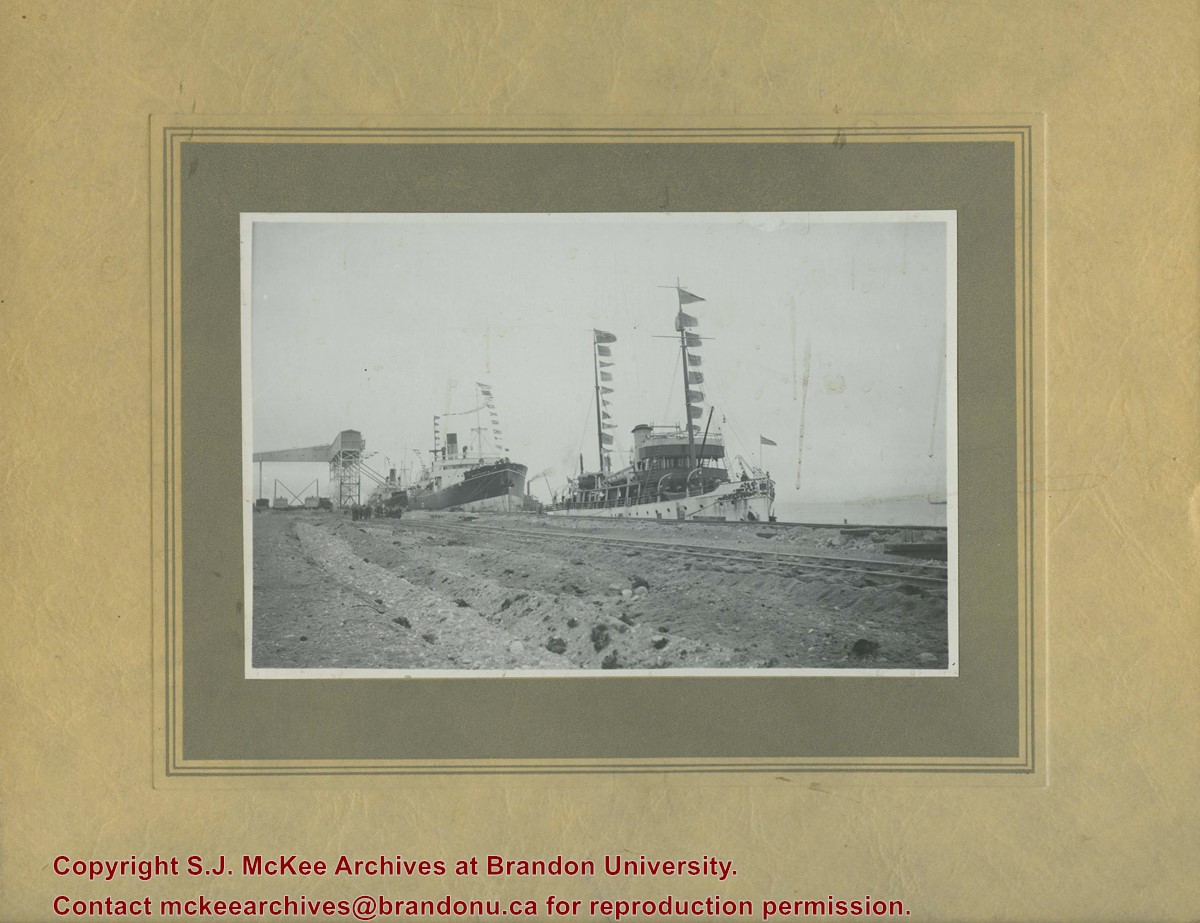
Photograph shows three steam ships docked in a port alongside railway tracks.
Notes
Writing on the back of the photograph reads: Churchill 1931 Sept 16 No. 3. Dr. Marion? Party. C.G.S. Acadia, S.S. Warkworth, S.S. Farnworth.
Marjorie M Wolfe (nee Poersch) was born in 1923 at Brunkild, MB. She attended Winnipeg Normal School and then moved to the Tarbolton area in the RM of Daly in the 1940s to take a job at the local school. While in Tarbolton she met local farmer Edward Emerson Wolfe (1921-2003). Together they had four children: Dwight, Carol, Reed and Warren. Marjorie and Edward lived on the family farm for 55 years, before Edward's health necessitated the couple move to Brandon. During the 1980s and early 1990s, Marjorie wrote the Tarbolton News column for the Rivers Gazette Reporter.
Custodial History
As part of the Westman Oral History Collection, this collection was accessioned by the McKee Archives in 1998. The original tapes from the Westman Oral History project were deposited in the Brandon Public Library. Copies of these originals were made by Margaret Pollex of the Brandon University Language Lab at the request of Eileen McFadden, University Archivist in the early 1990s. These copies compose the collection held in the McKee Archives.
Scope and Content
Item is an audiocassette tape containing an interview with Marjorie Wolfe about growing up int the 1930s and the history of Tarbolton School District. Interviewer is Mrs. K. Cochrane.
Notes
History/bio information from the records Edward Wolfe's obituary and an article in The Producer on the Wolfe farm. Description by Christy Henry.
Audio Tracks
Media missing or recording not available.
An unexpected error occurred.
Update Required
To play the media you will need to update your
browser to a recent version, or update your Flash plugin.
Speeches and addresses given by executives of the Manitoba Wheat Pool and MPE as well as argricultural experts and supporters of the co-operative movement helped to spread and solidify support for the Pools. They also served to educate rural members on a variety of topics. See fonds level description of RG 4 for complete history/bio of MPE.
Scope and Content
Sub-series MPE B.8 consists of speeches made by various important members and executives of Manitoba Pool Elevators. Records include the following:
1a. Addresses 1930 -1946
1b. Addresses 1946 -1954
2. Addresses 1954 -1960
3. Addresses 1969 -1975
4a. Addresses 1972 -1979
4b. Addresses 1972 -1979
5a. F.W. Hamilton Speeches 1967 -1973
5b. F.W. Hamilton Speeches 1962 -1966
5c. F.W. Hamilton Speeches 1960 -1962
5d. F.W. Hamilton Speeches 1949 -1960
6a. W.J. Parker Speeches 1945
6b. W.J. Parker Speeches 1940 -1944
7a. W.J. Parker Speeches 1948 -1950
7b. W.J. Parker Speeches 1946 -1948
8a. W.J. Parker Speeches 1954 -1958
8b. W.J. Parker Speeches 1951 -1954
9a. W.J. Parker Speeches 1968 -1970
9b. W.J. Parker Speeches 1960 -1967
10. F.W. Ransom Addresses 1942 - 1948
11. Miscellaneous Addresses 1948 - 1955; no dates
12. Miscellaneous Addresses 1960; no dates
13. E.S. Russenholt Addresses
14. V. Martens " The Implications of Including Protein in Segregrating Canadian Wheat"
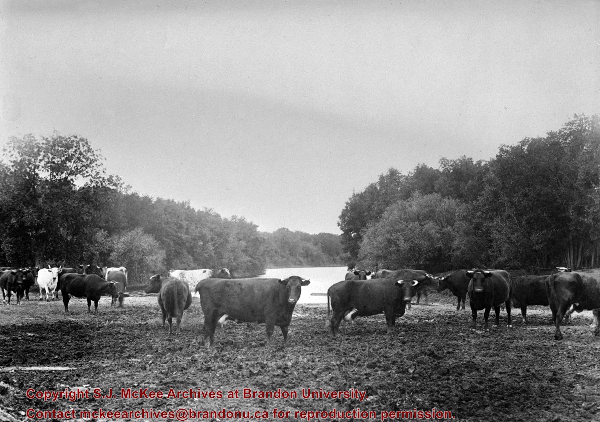
The Snye was a former channel (oxbow lake) of the Assiniboine River. It was located south of the Assiniboine between about 14th and 24th Streets, and during high water in the spring it carried overflow. For many years it was used as a log storage area for Hanbury's Mill. I remember there being bridges over it at 18th & 22nd Streets. It was dammed with a one way flipper valve at 14th Street that allowed water to flow out to the river, but prevented river water backing into it. Water within the Snye became stagnant in summer and formed a breeding area for mosquitoes. It was deemed a health hazard and the river was gradually filled in. LAS.
Custodial History
For custodial history see the collection level description of the Lawrence Stuckey collection.
Scope and Content
Snye River
Notes
[This negative was produced using a previous published image. P.E. 22/07/09]
Additional historical information provided by the Fred McGuinness collection (20-2009).
Due to the increasing volume of long-distance auto traffic in the 1920's, the city designated the block between Hill & Queen's Avenues and 9th & 10th streets as a "Tourist Camp" with a few basic facilities. LAS.
Custodial History
For custodial history see the collection level description of the Lawrence Stuckey collection.
Scope and Content
First Tourist Camp
Notes
Courtesy of the Brandon Sun
[Mr. Stuckey put two negatives in the same envelope, numbered N4 and N4a. We have separated them.]
For custodial history see the collection level description of the Lawrence Stuckey collection.
Scope and Content
Stanley Park from old PC.
Notes
Shows bandstand
[By "PC" Mr. Stuckey likely meant to indicate Park School (built 1904, demolished 1978). Park School was, at the time the photo was taken, located directly across Lorne Avenue from Stanley Park. P.E. 22/07/09]
This wedge-shaped tract of woodland was located west of 34th Street on the south side of the Canadian Pacific Railway. It was formerly owned by the Great Northern Railway, and was acquired by the CPR when the GN line was abandoned in 1936. In 1978 Marathon Realty (CPR) sold this 7 acre property to a developer who planned to build condominiums. However this residential development was objected to for two reasons: [The proposed location] was home to many species of flora & fauna, and it was too close to the CPR mainline. Local residents took out a petition against the development. [Mr. Stuckey] wrote a letter to the editor of the Brandon Sun, [expressing the] attitudes of CPR officials, and read a statement to the Provincial Planning Board suggesting development be refused and the area become an undeveloped park. These efforts would prove successful - see file on same.
Custodial History
For custodial history see the collection level description of the Lawrence Stuckey collection.
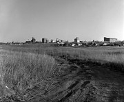
Scope and Content
John Indian's Bush (also known as Bang's Bush)
Notes
Additional historical information provided by the Fred McGuinness collection (20-2009). Stuckey's letter to the editor appears in the July 22, 1978 issue of The Brandon Sun.
This wedge-shaped tract of woodland was located west of 34th Street on the south side of the Canadian Pacific Railway. It was formerly owned by the Great Northern Railway, and was acquired by the CPR when the GN line was abandoned in 1936. In 1978 Marathon Realty (CPR) sold this 7 acre property to a developer who planned to build condominiums. However this residential development was objected to for two reasons: [The proposed location] was home to many species of flora & fauna, and it was too close to the CPR mainline. Local residents took out a petition against the development. [Mr. Stuckey] wrote a letter to the editor of the Brandon Sun, [expressed the] attitudes of CPR officials, and read a statement to the provincial planning board suggesting development be refused and the area become an undeveloped park. These efforts would prove successful - see file on same.
Custodial History
For custodial history see the collection level description of the Lawrence Stuckey collection.
Scope and Content
John Indian's Bush (also known as Bang's Bush).
Notes
Additional historical information provided by the Fred McGuinness collection (20-2009). Stuckey's letter to the editor appears in the July 22, 1978 issue of The Brandon Sun.
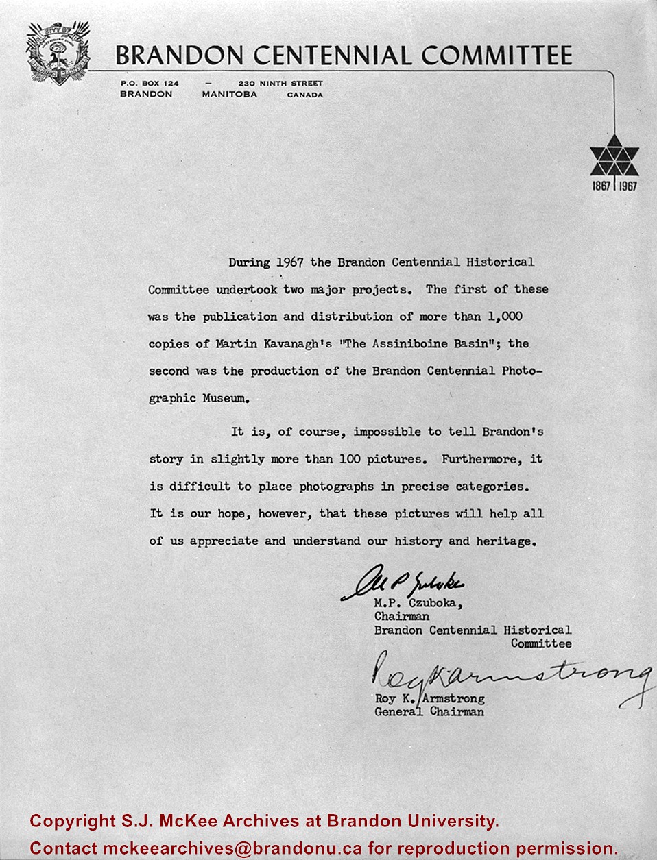
Contract for producing and framing 100 historical photos was awarded to myself as proprietor Clark Smith Studio. This gallery of photos is displayed in Neelin High School. LAS.
Custodial History
For custodial history see the collection level description of the Lawrence Stuckey collection.
Scope and Content
Letter outlining projects of National Centennial Committee of Brandon.
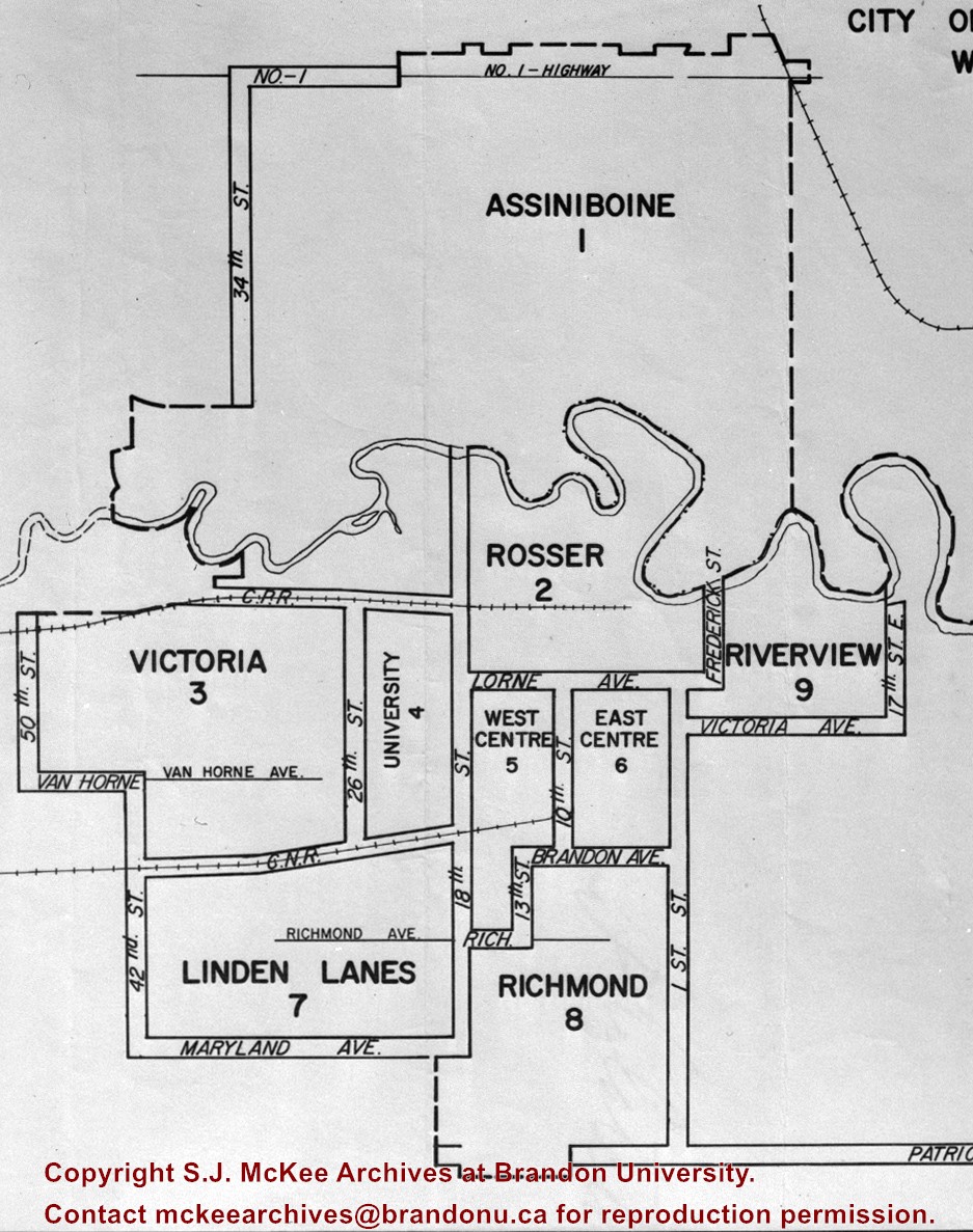
The City of Brandon (by decree of the Province) went to a ward system of government with the civic elections of October of 1971. Ten aldermen, who had to reside in their wards, were elected by the people of their wards. The Mayor was elected by the city at large. The previous committee system was abolished and individual aldermen henceforth had no specific responsibilities.
Custodial History
For custodial history see the collection level description of the Lawrence Stuckey collection.


.jpg?width=1200&404=no-img.jpg&watermark=wmk)
.jpg?width=180&404=no-img.jpg)
.jpg?width=1200&404=no-img.jpg&watermark=wmk)
.jpg?width=180&404=no-img.jpg)
.jpg%3fmaxheight%3d1000%26maxwidth%3d1000%26watermark%3dwmk&description=John+Indian%27s+Bush)
.jpg%3fmaxheight%3d1000%26maxwidth%3d1000%26watermark%3dwmk&description=John+Indian%27s+Bush)