Box contains minutes geenrated by local MPE associations, collected and microfilmed by the central office. Rolls in this box include the following:
Roll 13: Oakbank 1940-51; Oakburn 1940-51; Oak Lake 1928-51; Oakland 1928-51; Oakville 1928-51; Osbourne 1927-51; Rapid City 1926-51; Pierson 1928-51; Pilot Mound 1928-51; Pipestone 1929-51; Poplar Point 1947-51; Portage 1927-51; Purves 1928-51
Roll 14: Rapid City 1926-27; Rathwell 1928-51; Regent 1927-51; Reston 1927-51; Rhodes 1928-48; Riverton 1948-51; Sandy Lake 1943-51; Selkirk 1947-51; Roblin 1926-51; Rossburn 1929-51; Roundthwaite 1928-51; Russell 1940-51; Ste Agathe 1946-51; St Jean 1949-51; Sanford 1927-51; Scrick 1944-51
Roll 15: missing
Roll 16: Starbuck 1927-40; Stonewall 1939-51; Strathclair 1947-51; Swan Lake 1928-51; Teulon 1940-51; Thorn Hill 1926-51; Tilston 1928-51; Treherne 1928-51; Vista 1940-51; Warren 1947-51; Waskada 1925-51; Wawanesa 1927-51; Wood Bay 1937-51; Wood Bay 1926-37; Wood North 1928-51
Roll 17: Side 1 Alexander to Birdtail Oct 1951 – June 1957; Side 2 Birnie to Cartwright Oct 1951 – June 1957
Roll 18: Side 1 Chillon to Ebor Oct 1951 – June 1957; Side 2 Eden to Fork River Oct 1951 – June 1957
Roll 19: Side 1 Forrest to Hamiota Oct 1951 – June 1957; Side 2 Harding to Kronsgart Oct 1951 – June 1957
Roll 20: Side 1 Landseer to Maples Oct 1951 – June 1957; Side 2 Margaret to Napinka Oct 1951 – June 1957
Roll 21: Side 1 Neelin to Purvis Oct 1951 – June 1957; Side 2 Rapid City to Silverton Oct 1951 – June 1957
Roll 22: Side 1 Sinclair to Warren Oct 1951 – June 1957; Side 2 Waskada to Woodnorth Oct 1951 – June 1957
File consists of a request for approval in principle for financial assistance for special capital project to the Universities Grants Commission, correspondence and a copy of the grading design.
Storage Location
RG 6 Brandon University fonds
Series 2: Board of Governors
2.6 Board Projects
Box 1
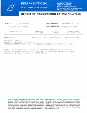
Radiocarbon date reports have been scanned in multi-page PDF files.
History / Biographical
North Lauder Radiocarbon Date report by Beta Analytic Inc. for Flintstone Hill #109900.
Radiocarbon dating
The technique of radiocarbon dating was developed by Willard Libby and his colleagues at the University of Chicago in 1949.
Radiocarbon dating is used to estimate the age of organic remains from archaeological sites. Organic matter has a radioactive form of carbon (C14) that begins to decay upon death. C14 decays at a steady, known rate of a half life of 5,730 years. The technique is useful for material up to 50,000 years. Fluctuations of C14 in the atmosphere can affect results so dates are calibrated against dendrochronology. Radiocarbon dates are calibrated to calendar years.
Dates are reported in radiocarbon years or Before Present. Before Present refers to dates before 1950. The introduction of massive amounts of C14, due to atomic bomb and surface testing of atomic weapons, has widely increased the standard deviation on all dates after A.D. 1700 causing these dates to be unreliable.
Accelerated mass spectrometry can more accurately measure C14 with smaller samples and can date materials to 80,000 years.
Scope and Content
Sub sub series contains radiocarbon dates from: Atkinson site and Flintstone Hill.
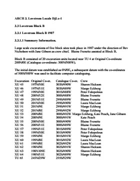
Block B consisted of 20 contiguous 1m2 units excavated to 30 cm below surface. (except unit 58 which was excavated to 35 cm bs to obtain extended soil profile). The block is situated in recent oak and poplar forest at the head of a ravine leading to Jock’s Creek, adjacent to an area cleared for market gardening. As was the case with Block A, the understory is heavily overgrown with hazelnut, chokecherry, saskatoon, and a poison ivy/sarsaparilla ground cover.
The soil levels below the sod in Block B consisted of a black, silty, and gritty loam layer from 5 cm to 23 cm below surface, a yellow and sandy clay from 23 cm to 30 cm below surface, and glacial till at 30 cm below surface. As in Block A, limestone cobbles were found throughout the occupation level around the bone. It is evident that bioturbation – primarily tree roots and rodent burrowing – have significantly altered patterns of original deposition of lithics, ceramics and small bone.
The faunal layer lay close to the surface, situated entirely in the black loam 5 cm – 23 cm below surface. The 23 cm depth also marked the end of the dark silty loam. At 10 cm below surface, a discernible patterning of the bone appeared. Concentrations of bone in narrow rows ran in an irregular pattern from the northwest to the southeast part of the block. This pattern was most apparent in the north end of the block which is the highest point in the block. In the same 1m2 unit, patches of weathered, very poorly preserved bone would be found lying close to patches of well preserved bone. It is believed that this variability in preservation results from uneven rates of burial due to taphic activities of pocket gophers or other agents of bioturbation. The same pattern of uneven preservation occurs over much of the locale but is most evident in Block B.
Diagnostic lithics included eleven projectile points that were predominantly Plains or Prairie Side-notch types, but included two unnotched triangular points. Cord-wrapped impressed rim sherds and body sherds were recovered. The ceramics are variants of the Woodland Blackduck horizon.
RC dates: XU49 – 675/80 BP XU 59 – 705/75BP.
Scope and Content
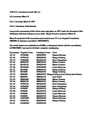
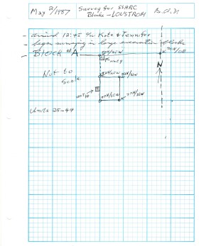
Sub-sub-sub series contains: Summary information of field methology, number and co-ordinates of excavations, personnel and their staff position; Field journals are daily records of recoveries, features and activities at the site; Site records include excavation level and unit summaries, feature sheets, profiles; sample records and maps; Artifact catalogues are lists and identifications of all artifacts recovered; Photographs are of excavation units, features, the landscape and personnel.
Field journals have been scanned in multi-page PDF files. Artifact catalogues are PDF files in spreadsheet format. Photographs are in jpeg format.
History / Biographical
Large scale excavations of five block sites took place in 1987 under the direction of Bev Nicholson with Jane Gibson as crew chief. Block B consisted of 21 excavation units.
Scope and Content
Sub-sub-sub series contains: Summary information of field methology, number and co-ordinates of excavations, personnel and their staff position.
Some of the pages and photographs in the scrapbooks have become loose
History / Biographical
Southwest B "Region" Women's Institute is a regional board within Manitoba Women's Institute.
According to their website, Manitoba Women’s Institute (MWI) operates under an umbrella structure of a provincial board and regional boards as directed in the Constitution and Bylaws. The provincial board serves to co-ordinate the activities of the organization on a provincial scale and link with other provincial, national, and international organizations. Regional boards are responsible for activities within their regions and for assisting with communication between the provincial board and the membership. Local institutes serve members in local communities or local geographic areas.
The Southwest B "Region" Women's Institute covers the area south of the Trans Canada Highway and from Killarney west to the Saskatchewan border. Historically it has encompassed locals from the follwing areas: Bardal, Boissevain, Broomhill, Dand, Deloraine, Dublin, Ebor, Elgin, Elva, Hartney, Kemnay, Lauder, Lyleton, Medora, Melita, Napinka, Pierson, Regent, Souris, Springvale, Tilston, Wakada and Whitewater.
Custodial History
Records were in the possession of the Southwest B Region Women's Institute until thier donation to the McKee Archives in 2014.
Scope and Content
Fonds consists of records created by the Southwest B Region Women's Institute during the course of their activities and operations.
Records include: eight minute books (1926-1997); a small scribbler listing Convention and some Board meeting attendance (2001-2013); and two Treasurer's/cash record books (1940-1944 and 1951-1992). The photographs are portraits of the Women's Institute Leadership Class (1961 and 1962), attendees on stage at the F.W.E.C Convention, Wolfville NS (July 1964) and the Manitoba delegation to Wolfville NS (July 1964).
Notes
History/Bio information was taken from the records and from the Manitoba Women's Instutite webpage (http://www.mbwi.ca/about-mwi/local-institutes/. Accessed January 2017). Description by Christy Henry.
Finding Aid
A detailed list of meeting dates for the minute books was provided by the donor. It is located in the donation file.
Storage Location
2016 accessions
photographs in RG 5 photograph drawer by accession number