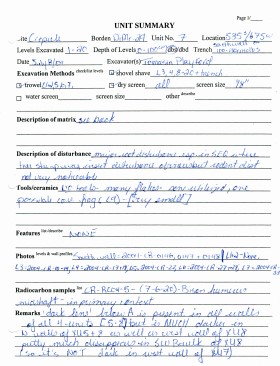
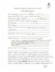
Record of site excavation unit 7at the Crepeele site 2004.
Scope and Content
Site records of excavation units may include: level summaries, floor plans, feature sheets, wall profiles, unit summaries and any other additional information relating to the unit.
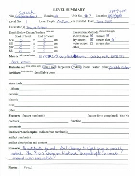
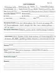
Record of site excavation unit 7at the Sarah site 2003.
Scope and Content
Site records of excavation units may include: level summaries, floor plans, feature sheets, wall profiles, unit summaries and any other additional information relating to the unit.
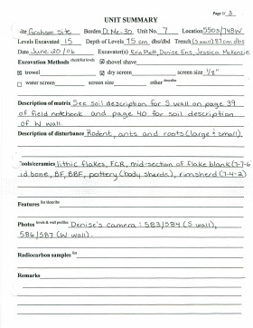
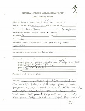
Record of site excavation unit 7 at Graham site 2006.
Scope and Content
Site records of excavation units may include: level summaries, floor plans, feature sheets, wall profiles, unit summaries and any other additional information relating to the unit.
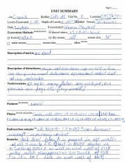
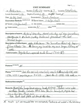
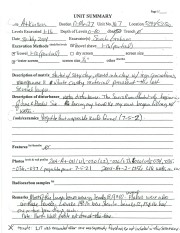
Record of excavation unit 7 at the Atkinson site 2004.
Scope and Content
Site excavation records of excavation units may include: level summaries, floor plans, feature sheets, wall profiles, unit summaries and any other additional information relating to the unit.
Record of site excavation test unit 7 at the Lovstrom survey 1985.
Scope and Content
Site records of excavation units may include: level summaries, floor plans, feature sheets, wall profiles, unit summaries and any other additional information relating to the unit.
The Medicine Hat Exhibition and Stampede Parade Day was held on Thursday, July 19, 1962, at 9:30 a.m. The local newspaper reported that approximately 24,000 people were in attendance to see parade marshall Rod Ashburner leading 175 entries consisting of 90 floats, 75 horses, and 10 bands. There were 19 parade categories eligible for $12,000 in prize money and included: junior and senior cowboys and cowgirls; fancy and Shetland ponies; sulky class open; comic, commercial, industrial and organizational floats; decorated cars; special ranch class; 4-H Clubs; and a non-competitive class.
The parade route started at Second St. and Allowance Ave., from Second St. to Ash Ave., north on Ash to First St. SE., from First St. S.E. to Fourth Ave., south to Second St. to South Railway St., south on South Railway St. to Third St., with a finish at McLeod Trail. A route map was published in the Medicine Hat News the day before the parade.
Aerial photographs of the parade were taken by Medicine Hat News photographer Howard Heid (1930-2005) from the private helicopter of John Bourn. Bourn was a pilot from Woodville, Wisconsin, who chartered his four-seater helicopter for sight-seers at exhibitions and stampedes across the county.
(Sources: Pat Currie, "Let 'Er Go!," Medicine Hat News, 19 July 1962,1; Harald Gunderson, "'Eye in the Sky' Best Parade View," Medicine Hat News, 19 July 1962,1; "Parade Starts at 9:30 Sharp," 18 July 1962)
Scope and Content
Photograph shows an aerial view of the Medicine Hat Exhibition and Stampede Parade route with a focus on the First Street SE and Sixth Avenue intersection. A number of gas stations and garages are visible along this route and include Texaco, Shell, Ford, and B/A. A number of observers can be seen sitting on rooftops.
Notes
This photograph shows the neighbourhood before rezoning and commercial development.
Sub sub series consists of documents relating to various Board projects including the Evans Lecture Theatre, the Library Building, a sanitary trunk sewer, electrical and telephone distribution service and the steam plant extension. There are also files on the Brandon University Chancellor and long range planning consultants. The sub sub series includes correspondence, minutes, blue prints, reports, financial information, statistics, recommendations and other records.
Storage Location
RG 6 Brandon University fonds
Series 2: Board of Governors
2.6 Board Projects
See also fonds level description of RG 4 for history/bio of MPE
Scope and Content
.This sub-series contains the following:
Box 1:
1. Canadian Agricultural Miscellaneous 1967-1972
2. Canadian Agricultural Miscellaneous 1973-1975
3. Canadian Agricultural Miscellaneous 1970-1975
4. Bill C-175 An act respecting grain
5. Bill C-196 Canada Grain Act 1970
Box 2:
6a. Canadian Agricultural Miscellaneous 1971
6b. Canadian Agricultural Miscellaneous 1971
7a. Bill C-41 The Western Grain Stabilization Act 1975
7b. Bill C-41 The Western Grain Stabilization Act 1975
8. General Agricultural Policy
9. Manitoba Agriculture 1936
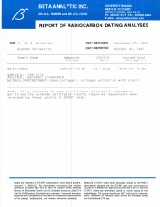
Radiocarbon date reports have been scanned in multi-page PDF files.
History / Biographical
North Lauder Radiocarbon Date report by Beta Analytic Inc. for Flintstone Hill #109900.
Radiocarbon dating
The technique of radiocarbon dating was developed by Willard Libby and his colleagues at the University of Chicago in 1949.
Radiocarbon dating is used to estimate the age of organic remains from archaeological sites. Organic matter has a radioactive form of carbon (C14) that begins to decay upon death. C14 decays at a steady, known rate of a half life of 5,730 years. The technique is useful for material up to 50,000 years. Fluctuations of C14 in the atmosphere can affect results so dates are calibrated against dendrochronology. Radiocarbon dates are calibrated to calendar years.
Dates are reported in radiocarbon years or Before Present. Before Present refers to dates before 1950. The introduction of massive amounts of C14, due to atomic bomb and surface testing of atomic weapons, has widely increased the standard deviation on all dates after A.D. 1700 causing these dates to be unreliable.
Accelerated mass spectrometry can more accurately measure C14 with smaller samples and can date materials to 80,000 years.
Scope and Content
Sub sub series contains radiocarbon dates from: Atkinson site and Flintstone Hill.
In the summer of 1986, faculty members at Brandon University developed a project aimed at identifying the archival records that existed in public and private collections throughout western Manitoba. A grant was secured from the Manitoba Heritage Federation, and reseachers were employed to travel throughout the region to identify and record the wide variety of records. The results of their work was a four volume set of inventories.
Custodial History
W.R. Morrison left the university in 1991. At the time he gave Tom Mitchell copies of volumes 1-3. In 2006, John Everitt provided the archives with a copy of volume 4.
Scope and Content
Fonds consists of four volumes: 1987, 1988, 1989 and 1991. The inventories were generated through extensive research at various centres throughout western Manitoba. Each inventory contains a record of archival materials held by individuals, organizations and/or municipalities throughout the region.


