Jack Stothard was born on February 16, 1932 in Brandon, MB. He attended public schools in the city (Central School, Park School, and Earl Oxford) and graduated from Brandon Collegiate Institute (BCI). Stothard married Velma Pollock in 1957 and together they had two daughters: Debra and Kimberly. Stothard was employed in the plumbing and heating business until 1960, when he joined Manitoba Hydro. In the course of his employment with Manitoba Hydro, he became Station Superintendent of the Brandon Generating Station. Stothard retired in 1995. Stothard was a member of the Canadian Numismatic Association, the Canadian Association of Token Collectors and the Toronto Postcard Club. Jack Stothard died on November 3, 2021 in Brandon, MB.
Custodial History
Accession 1-2003 was in the possession of Stothard until donated to the McKee Archives in 2003. Accession 12-2006 was acquired by Lawrence Stuckey at some point after the photograph was taken. Stuckey later sold a copy of the photograph. This copy was later acquired by Jack Stothard in the course of his collecting of Brandon postcards. Stothard donated the image to the McKee Archives in 2004. Accession 8-2007 was prepared by Jack Stothard in the course of 2007. He provided a copy to the Archives upon its completion. Accession 8-2008 was in the possession of Fred McGuinness until he gave jit to Jack Stothard in February 2008. Stothard donated the records to the McKee Archives on February 12, 2008. Accession 18-2008 was donated to the McKee Archives by Stothard on August 18, 2008. Accession 11-2009 was donated to the McKee Archives by Stothard on February 20, 2009. Accession 4-2012 was donated to the McKee Archives by Stothard on August 24, 2011. Accession 4-2013 was donated to the McKee Archives by Stothard in March 2013. Accession 8-2016 was donated to the McKee Archives by Stothard on January 21, 2015.
Scope and Content
Accession 1-2003 contains brief research reports prepared by Stothard on various topics concerning historical Brandon. These include: a listing of hotels, inns and motels that have operated in Brandon since the 1880s; reports dealing with the Café Aagard, Central United Church, the 1913 Dominion Exhibition, Brandon, the Empire Hotel, Brandon’s Central Steam Heating System, the Post Office and the Clement Block. It also contains one booklet: Facts About Brandon: An Industrial Survey of the City of Brandon. Winnipeg: Department of Industry and Commerce [n.d.]
Accession 12-2006 consists of one photograph of the Great Northern Engine 208, built by Rogers Locomotive Company 1887. Cylinders 18 x 24, Drivers 63". G.N. line Church's Ferry, N.D. to Brandon, Manitoba. Opened 1906, Closed 1936.
Accession 8-2007 consists of a brief typed report entitled "The Day the Lights Went Out in Brandon - Strike of 1919" by Jack Stothard. Document provides an account of the sources and delivery of hydro electric power to Brandon beginning in the early 1900s and the brief power outage at the beginning of the Brandon General Strike May 25, 1919.
Accession 8-2008 consists of "The Brandon Sun Challenge Cup" ledger, which contains two b/w photographs, newspaper clippings and information on the history and first race (1908) of the cup; 3 additional b/w photographs of different races; and the Brandon Old Timers Association record book (c. 1900).
Accession 18-2008 consists of a copy of Stothard's Brandon Postcards index. The index is divided into various sub-headings and consists of colored reproductions of postcards in Stothard's collection. The index contains pages that were discarded by Stothard as he updated his inventory, therefore the index is only up to date as of August 18, 2008.
Accession 11-2009 consists of a typed research report entitled "Brandon Police Department Stations and Locations" by Jack Stothard. The report outlines the location of the Brandon Police Department from 1882 - 2008, and also includes a section on "What the Future Holds."
Accession 4-2012 consists of pages for Stothard's Brandon Postcards index (18-2008) and a photocopy of a Brandon Municipal Railway ticket.
Accession 4-2013 consits of eight binders of handwritten notes/facts about Brandon compiled by Jack Stothard. The notes are a collection of names, places, things, events and items related mostly to the first 100 years of Brandon (1882-1982), although the notes continue into the 2000's. Some notes centre on the late 1930's to early 1950's during the period of Stothard's youth. The information in the binders was taken from a variety of publications, while some notes are Stothard's own comments. A list of sources, as well as a cross reference index for all eight binders, can be found in Book No. 1.
The accession includes: Book No. 1 - Notes of Brandon (A to B); Book No. 2 - Notes of Brandon (C to F); Book No. 3 - Notes of Brandon (G to O); Book No. 4 - Notes of Brandon (P to Z); Book No. 5 - Notes of Brandon: Churches, Hostpitals, Hotels; Book No. 6 - Notes of Brandon: Police Department, Fire Department; Book No. 7 - Notes of Brandon: Brandon City Council, City of Brandon etc.; Book No. 8 - Notes of Brandon: Brandon College/University, Brandon Schools, ACC, Brandon School Board. Accession also includes pages from Stothard's Brandon Postcards index (18-2008).
Accession 6-2016 consists of local history books, pamphlets, bakery tokens, local magazines, one binder containing handwritten notes/facts about Brandon compiled from the Brandon Sun's "Looking Back" column, and an accordian file box containing newspaper clippings about Brandon.
The accession includes the following local history books: Betty Watson's "One Day in Brandon Manitoba 9/9/99" (Brandon, Manitoba: Bart Art Books, 1999); P.N. Breton's "Popular Illustrated Guide to Canadian Coins, Medals, &. &.," (Winnipeg: Canadian Numismatic Publishing Institute, 1963 [reprint]); "Facts About Brandon: An Industrial Survey of the City of Brandon," (Province of Manitoba: Department of Industry and Commerce, [1946]); The Polish Gymnastic Association Sokol's "75th Anniversary: From the Past to the Future!" ([Brandon, Manitoba: Polish Gymnastic Association Sokol, 1988]); and Brandon Kinsmen Club's "'Together...Once Again': A History of the Kinsmen Club of Brandon, Manitoba, 1925-1975 (Brandon, Manitoba: The Historical Committee of the Kinsmen Club of Brandon, 1975).
Pamplets and magazines include: Brandon Generating Station (1957) and (1969), The Brandon Quota Club presents...A Century in Revue (1982), Canadian Rail No. 168/July-August 1965 [featuring Brandon Municipal Railway], Prairie City Issue No. 3/1994, and Prairion May/June 1997.
The binder is titled Book No. 9 - "Year by year: miscellaneous items from 1969 to 2000"; an asterik (*) indicates notes have been made on each subject or item in the other Books. Each section is housed in
The files in the accordian file box have been rehoused and include the following topics: banks, Brandon 125 beer, Behlen Industries, breweries, Brandon Shoppers' Mall, calendars, Canadian Motors Ltd., Canexus/Nexen, Canada Games - Summer and Winter, Canadian Tire, CKX Radio & TV/CKLQ, Corral Centre, flour mills, hospitals, Keystone, Maple Leaf, Fred McGuinness, miscellaneous, A.E. McKenzie, people, railways, Simplot, Westman Recycling (new facility), weather-storms-floods, and extra copies of postcards.
Notes
Description by Christy Henry. Accession 4-2013: Book No. 1 contains a photocopied photograph of Aagaard's Cafe, photographs of the Dominion Bank and Barney's Drive Inn and a photo reproduction of the Bass Building. Book No. 2 contains a photograph of the Provincial Goal. Book No. 3 contains photographs of T. Eaton Company (4 construction photos) and a photo reproduction of tents on the Exhibition grounds (c. 1940). Book No. 4 contains photoraphs of the Oak Theatre and Western Motors. There are also photopied photographs of The Fun Shop.
Field journals have been scanned in multi-page PDF files. Artifact catalogues are PDF files in spreadsheet format. Photographs are in jpeg format.
History / Biographical
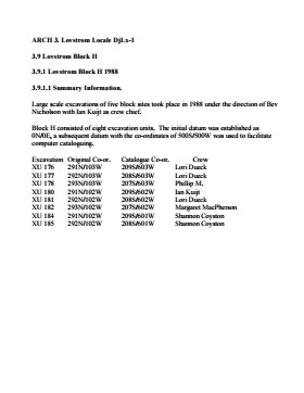
Large scale excavations of four block sites took place in 1988 under the direction of Bev Nicholson with Ian Kuijt as crew chief. Block H consisted of eight excavation units.
Scope and Content
Sub-sub-sub series contains: Summary information of field methology, number and co-ordinates of excavations, personnel and their staff position.
Field journals have been scanned in multi-page PDF files. Artifact catalogues are PDF files in spreadsheet format. Photographs are in jpeg format.
History / Biographical
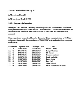
Large scale excavations of two block sites took place in 1988 under the direction of Bev Nicholson with Brett Waddell as crew chief and Theresa Hill as assistant. Block H consisted of nine additional excavation units.
Scope and Content
Sub-sub-sub series contains: Summary information of field methology, number and co-ordinates of excavations, personnel and their staff position.
Radiocarbon date reports have been scanned in multi-page PDF files.
History / Biographical
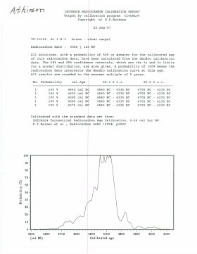
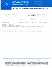
North Lauder Radiocarbon Date report by IsoTrace Laboratory for Atkinson site #TO-10640.
Radiocarbon dating
The technique of radiocarbon dating was developed by Willard Libby and his colleagues at the University of Chicago in 1949.
Radiocarbon dating is used to estimate the age of organic remains from archaeological sites. Organic matter has a radioactive form of carbon (C14) that begins to decay upon death. C14 decays at a steady, known rate of a half life of 5,730 years. The technique is useful for material up to 50,000 years. Fluctuations of C14 in the atmosphere can affect results so dates are calibrated against dendrochronology. Radiocarbon dates are calibrated to calendar years.
Dates are reported in radiocarbon years or Before Present. Before Present refers to dates before 1950. The introduction of massive amounts of C14, due to atomic bomb and surface testing of atomic weapons, has widely increased the standard deviation on all dates after A.D. 1700 causing these dates to be unreliable.
Accelerated mass spectrometry can more accurately measure C14 with smaller samples and can date materials to 80,000 years.
Scope and Content
Sub sub series contains radiocarbon dates from: Atkinson site and Flintstone Hill.
Radiocarbon date reports have been scanned in multi-page PDF files.
History / Biographical
North Lauder Radiocarbon Date report by IsoTrace Laboratory for Atkinson site #TO-13365.
Radiocarbon dating
The technique of radiocarbon dating was developed by Willard Libby and his colleagues at the University of Chicago in 1949.
Radiocarbon dating is used to estimate the age of organic remains from archaeological sites. Organic matter has a radioactive form of carbon (C14) that begins to decay upon death. C14 decays at a steady, known rate of a half life of 5,730 years. The technique is useful for material up to 50,000 years. Fluctuations of C14 in the atmosphere can affect results so dates are calibrated against dendrochronology. Radiocarbon dates are calibrated to calendar years.
Dates are reported in radiocarbon years or Before Present. Before Present refers to dates before 1950. The introduction of massive amounts of C14, due to atomic bomb and surface testing of atomic weapons, has widely increased the standard deviation on all dates after A.D. 1700 causing these dates to be unreliable.
Accelerated mass spectrometry can more accurately measure C14 with smaller samples and can date materials to 80,000 years.
Scope and Content
Sub sub series contains radiocarbon dates from: Atkinson site and Flintstone Hill.
Radiocarbon date reports have been scanned in multi-page PDF files.
History / Biographical
North Lauder Radiocarbon Date report by Beta Analytic Inc. for Flintstone Hill #109529 and #109530.
Radiocarbon dating
The technique of radiocarbon dating was developed by Willard Libby and his colleagues at the University of Chicago in 1949.
Radiocarbon dating is used to estimate the age of organic remains from archaeological sites. Organic matter has a radioactive form of carbon (C14) that begins to decay upon death. C14 decays at a steady, known rate of a half life of 5,730 years. The technique is useful for material up to 50,000 years. Fluctuations of C14 in the atmosphere can affect results so dates are calibrated against dendrochronology. Radiocarbon dates are calibrated to calendar years.
Dates are reported in radiocarbon years or Before Present. Before Present refers to dates before 1950. The introduction of massive amounts of C14, due to atomic bomb and surface testing of atomic weapons, has widely increased the standard deviation on all dates after A.D. 1700 causing these dates to be unreliable.
Accelerated mass spectrometry can more accurately measure C14 with smaller samples and can date materials to 80,000 years.
Scope and Content
Sub sub series contains radiocarbon dates from: Atkinson site and Flintstone Hill.
Radiocarbon date reports have been scanned in multi-page PDF files.
History / Biographical
North Lauder Radiocarbon Date report by Beta Analytic Inc. for Flintstone Hill #111142 and #111143.
Radiocarbon dating
The technique of radiocarbon dating was developed by Willard Libby and his colleagues at the University of Chicago in 1949.
Radiocarbon dating is used to estimate the age of organic remains from archaeological sites. Organic matter has a radioactive form of carbon (C14) that begins to decay upon death. C14 decays at a steady, known rate of a half life of 5,730 years. The technique is useful for material up to 50,000 years. Fluctuations of C14 in the atmosphere can affect results so dates are calibrated against dendrochronology. Radiocarbon dates are calibrated to calendar years.
Dates are reported in radiocarbon years or Before Present. Before Present refers to dates before 1950. The introduction of massive amounts of C14, due to atomic bomb and surface testing of atomic weapons, has widely increased the standard deviation on all dates after A.D. 1700 causing these dates to be unreliable.
Accelerated mass spectrometry can more accurately measure C14 with smaller samples and can date materials to 80,000 years.
Scope and Content
Sub sub series contains radiocarbon dates from: Atkinson site and Flintstone Hill.
Radiocarbon date reports have been scanned in multi-page PDF files.
History / Biographical
North Lauder Radiocarbon Date report by Beta Analytic Inc. for Flintstone Hill #109900.
Radiocarbon dating
The technique of radiocarbon dating was developed by Willard Libby and his colleagues at the University of Chicago in 1949.
Radiocarbon dating is used to estimate the age of organic remains from archaeological sites. Organic matter has a radioactive form of carbon (C14) that begins to decay upon death. C14 decays at a steady, known rate of a half life of 5,730 years. The technique is useful for material up to 50,000 years. Fluctuations of C14 in the atmosphere can affect results so dates are calibrated against dendrochronology. Radiocarbon dates are calibrated to calendar years.
Dates are reported in radiocarbon years or Before Present. Before Present refers to dates before 1950. The introduction of massive amounts of C14, due to atomic bomb and surface testing of atomic weapons, has widely increased the standard deviation on all dates after A.D. 1700 causing these dates to be unreliable.
Accelerated mass spectrometry can more accurately measure C14 with smaller samples and can date materials to 80,000 years.
Scope and Content
Sub sub series contains radiocarbon dates from: Atkinson site and Flintstone Hill.
See RG 6 Brandon University fonds, Series 7 Faculties and Schools, Sub-series 7.1 Faculty of Arts, Sub sub series 7.1.1 Dean of Arts for biographical information for Michael Blanar.
Custodial History
Collection was in the possession of Dr. Michael Blanar until he donated the records to the S.J. McKee Archives in May 2002.
Scope and Content
Collection consists of textual records and five microfilm reels related to Dr. Blanar’s post-graduate research. It is assumed that the records were collected during the course of Blanar’s research for his dissertation entitled “Early British Travellers in French Canada (1960).”
Textual records include three Dominion of Canada notebooks containing handwritten Saulteaux verbs, and animate nouns. Included is a dark red booklet titled “Ojibwe.” The book contains Ojibwa translations of English words. The book comes from St. Peter Clavers Industrial School in Spanish, Ontario, and may have acted as an instructional book as it also contains French and English. Collection also contains a transcript of an Ojibwa dictionary and three file folders titled “Manuscripts,’ “John Long Research,” and “Maps” which contain additional research material. Contents of “Manuscript” folder are original typed manuscripts. “John Long” and “Maps” file folders contain copies of materials held at Library and Archives Canada, as well as hand drawn documents and hand written documents detailing contents of folders.
In addition to the textual records there are five microfilm reels. Three microfilm cases are labeled “The British Reference Division,” one case labeled “Public Archives Canada, central microfilm operations,” and the last case is from an unidentified source labeled “Longs voyages and travels”. Four of the five microfilm cases are also numbered. The British Reference Division microfilm case numbered “1346 i 43” contains a copy of a book titled “The Cacique of Ontario.” British Reference Division microfilm case numbered “104706640” contains a copy of a book titled “The Four Kings of Canada.” British Reference Division microfilm case numbered “9073279” contains a copy of a book titled “The Indians.” The Public Archives Canada microfilm case numbered “c-3006” contains copies of original documents in French and English. Documents include letters, diary pages, maps, and business ledgers. Microfilm case labeled “Longs voyages and travels” contains a copy of a book written by John Long titled “Voyages and Travels of Indian Interpreter and Trader.”
Notes
Description by Aaron McKay (October 2013). The Ojibwa language dictionary and notebook make references to Fredric Baraga (1797-1868), a missionary priest from Slovenia who recorded the Lake Superior Ojibwa language dialect. Baraga’s findings were published into an Ojibwa language dictionary.
The Atkinson site was named for the landowners Ken and Karen Atkinson who were very helpful to the archaeology and geoarchaeology crews that worked at the site. Their support made the project possible.
The Atkinson site story begins with the discovery of a charcoal lens eroding from the north bank of the Souris River in the summer of 2002. Study of Cultural Adaptations on the Prairie Ecozone (SCAPE) project geoarchaeologist Dr. Garry Running was exploring the stratigraphic layering in the bank when he noted the lens and reported it to Dr. Bev Nicholson. Upon closer examination, a tiny pressure flake was observed on the lens exposure and it was decided to collect a charcoal sample for radiocarbon dating.
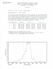
The resulting date of 5250B.P cal. 4225 B.C. placed the site in the early Archaic period. A second date on bone collagen of 5580B.P. cal. 4500 B.C. confirmed the earlier date and gave an averaged date of circa 4400 B.C or 6,500 years ago.
The Atkinson site is one of the oldest excavated sites in Manitoba. Based on the date of the site and the kind of lithics (stone tools) present it is considered a Gowen occupation. The Atkinson site is evidence that bison hunters were active on the northern plains at a very early date. Similar sites have also been found on the High Plains in the U.S. and are referred to as the Mummy Cave Complex.
The Atkinson Site is of great importance as it is the first undisturbed site of this type to be excavated in Manitoba and extends the range of these sites south and east from the type-sites in central Saskatchewan. Based on the date and sample evidence further excavations were conducted by Dr. Nicholson's team. in 2003, 2004 and 2006.
Scope and Content
Sub series has been divided into three sub sub series including: (1) Atkinson 2003, (2) Atkinson 2004; (3) Atkinson 2006
Flintstone Hill is located on the north bank of the Souris River. It is a deeply stratified lacustrine, fluvial and aeolian soil profile that has been exposed by the river through stream-bank erosion. This section is thought to be the most complete middle to late Holocene exposure on the northeastern plains. While the value of the site is primarily for paleo-environmental research and reconstruction, cultural deposits have been identified at the site. Local collectors have picked up lithic materials as they eroded out of the bank for the past several decades and it was they who had named the site. Mr. Bruce Timms from Lauder first drew the Flintstone Hill site to the attention of Dr. Nicholson of Brandon University.
During the mid 1990’s to the early 2000’s archaeological testing took place on Flintstone Hill. In 1998, an archaeological field crew dug a series of overlapping trenches down the slope of the profile and produced a schematic drawing. A peat layer at the bottom of this profile, dated from the top at 9,400 RCY and at the bottom to 10,400 RCY, has provided details of marsh plant and insect communities at this time.
Subsequent archaeological investigations at the site recovered several cultural deposits including: a hearth dating to 3250+/-70 R.C.Y. (BETA 109529); a butchered atlas bone 4090+/-70 R.C.Y. (BETA 109990); and bone fragments accompanied by Swan River Chert and Knife River Flint lithic flakes 5350+/-50 (BETA 109530). While no diagnostic tools were recovered, these dates suggest that this occupation, which is contemporary with the Atkinson site, may be a Gowen occupation.
Extensive paleo-environmental research has been conducted at the site. Dr. Running, a geomorphologist from the University of Wisconsin – Eau Claire, participated in the Study of Cultural Adaptations in the Prairie Ecozone (SCAPE) Project and he and his students tested the site for several years. He was joined in this effort by Dr. Havholm, Dr. Boyd, Dr. Wiseman, Dr. Beaudoin, and other SCAPE researchers in the interpretation of the paleo-environment of the Glacial Lake Hind basin. The following article is recommended reading.
Running, Garry L., Karen G. Havholm, Matt Boyd and Dion J. Wiseman
2002 Holocene Stratigraphy and Geomorphology of Flintstone Hill, Lauder Sandhills, Glacial Lake Hind Basin, Southwestern Manitoba. Geographie Physique et Quaternaire
56(2-3):291-303.
Scope and Content
Sub series has been divided into two sub sub series including: (1) Flintstone Hill 1997 (2) Flintstone Hill 1998-2000
Field journals have been scanned in multi-page PDF files. Artifact catalogues are PDF files in spreadsheet format. Photographs are in jpeg format.
History / Biographical
Based on the results of the testing in 2002 and the radiocarbon date of 6,500 years before present, further excavation was warranted at the Atkinson site. In 2003 Field Chief Holly Alston and crew Shayne Kolesar and Andrea Richards opened a 42m test excavation (units 1 - 4) that included the hearth area.
The site area was covered with a huge sand dune that was slowly sliding into the river as the supporting bank eroded away. As the dune was removed a late woodland camp was found at the dune interface and a large chunk of charcoal dated this occupation to 440+/-60 B.P. cal.1440A.D. This indicated that the dune was a relatively late incursion over the site. This occupation is likely connected to subsequent testing to the east in 2005 that came to be known as Atkinson II.
Methodology:
The crew began shovel shaving the upper strata with the intention of establishing an arbitrary datum when artifacts were encountered or when a level 25cm above the hearth was reached. At 25cm above the hearth an arbitrary surface datum was established and excavation in 5cm levels began. The overbank deposited matrix was a dense, compacted silt clay and it was necessary to soak the excavated materials in buckets and then water screen the material with a high pressure pump over ¼ inch hardware cloth.
Lithic flakes were found at 10cm below datum, above the hearth level. In the next level, large bone, a broken projectile point and additional flakes were found. Increasing amounts of bone and lithic flakes were found as the excavation continued through levels 3 to 5. The top of the hearth was identified at 28cm below datum, below a 2cm layer of well-sorted sand. This sand layer was confined to a small area directly overlying the hearth. It was considered to be a deliberate quenching of the hearth.
After the conclusion of excavating level 6 the hearth was profiled and photographed. The charcoal and ash layer of the hearth was shown to be directly below the sand layer. Levels 6 and 7 revealed a bison bone bed that was consistent with primary and secondary butchering including elements from the vertebral column and appendicular skeleton. Two additional Gowen (Mummy Cave Series) projectile points were also recovered adjacent to the hearth. Level 8 continued to produce larger amounts of bone and many lithic flakes. Level 9 produced a few bone fragments and a small number of lithic flakes. At the conclusion of the excavations, the crew shoveled sand down from the dune to protect the site over winter and through any subsequent spring flooding.
Scope and Content
Sub-sub-sub series contains: Summary information of field methology, number and co-ordinates of excavations, personnel and their staff position; Field journals are daily records of recoveries, features and activities at the site; Site records include excavation level and unit summaries, feature sheets, profiles; sample records and maps; Artifact catalogues are lists and identifications of all artifacts recovered; Photographs are of excavation units, features, the landscape and personnel.
Field journals have been scanned in multi-page PDF files. Artifact catalogues are PDF files in spreadsheet format. Photographs are in jpeg format.
History / Biographical
In 2004 Tomasin Playford and her crew of Andrea Richards, Sarah Graham and Shane Kolesar cleared sand cover from over the 2003 excavations and extended sand clearing back from the north edge of the 2003 units to permit implementation of four additional units. During this sand clearing a hearth was identified together with small numbers of lithics and pottery body sherds. This occupation had been noted during sand clearing in 2003 and a charcoal sample was collected and radiocarbon dated to 1440 A.D. This hearth was assigned to Atkinson II, a later occupation.
Four units (5, 6, 7, & 8) were surveyed in adjacent to the 2003 units. Excavation proceeded by means of shovel shaving until the datum pegs from the previous year were located. The new units were then given datum pegs and string boundaries and the high pressure pump was set up for water screening of silt/clay matrix.
Continued to shovel shave levels 1 - 4 and recovered small burned and unburned bone fragments. Level 5 produced a projectile point, an end scraper and a large heat-treated Swan River Chert (SRC) flake. Other SRC flakes were also recovered. Levels 6 and 7 yielded large numbers of flake debitage. The matrix in levels 5-7 contained a scatter of small, bright red ochre particles. The river began to rise on the ninth of June and the site was sandbagged on June 11th, temporarily bringing an end to excavation for Atkinson 1. Tomasin and her crew were relocated to the Crepeele site, west of Lauder.
On July 20th, Tomasin and her crew returned to the Atkinson site and commenced cleaning up the earlier excavation following the flooding. Following the clean up, excavations were resumed on the units that had been opened. An additional Gowen point was recovered from level 8 as well as some poorly preserved bison bone. A lot flakes and small amounts of bone were recovered on west side of block and larger bone and flakes in bone bed along the east side in levels 8 - 10. Two bifaces were recovered in level 11 and a third in level 13. The excavations were terminated at level 18 when water started coming up through the unit floors.
Scope and Content
Sub-sub-sub series contains: Summary information of field methology, number and co-ordinates of excavations, personnel and their staff position; Field journals are daily records of recoveries, features and activities at the site; Site records include excavation level and unit summaries, feature sheets, profiles; sample records and maps; Artifact catalogues are lists and identifications of all artifacts recovered; Photographs are of excavation units, features, the landscape and personnel.
Field journals have been scanned in multi-page PDF files. Artifact catalogues are PDF files in spreadsheet format. Photographs are in jpeg format.
History / Biographical
The Atkinson site had been flooded in 2005 and there was concern about the amount of damage that might have occurred. A small crew of Tomasin Playford, Michelle Drysdale and Jessica McKenzie returned to the Atkinson site with the goals of obtaining a detailed profile of the stratigraphy at the north end of the occupation and to determine if the site extended contiguously towards the east. Two test pits were planned as well as the investigation of a couple of hearths found eroding from the riverbank Work commenced July 4th and finished July 21st.
To the north of XU 8 (Gowen occupation) an excavation unit 18 was opened and shovel shaved to a depth of 200cm. At 195cm below surface a point bar deposit was identified indicating that any lower occupations would likely have been eroded by an earlier channel cutting event prior to formation of this point bar depositional event. Golf tees were inserted into the edge of the profile to indicate the 5cm levels superimposed on a digital photo of the section. Lithic flakes and bone fragments were scattered thoughout the stratigraphic column. A radiocarbon date of 440 B.P. was obtained from the unit, indicating a much later occupation than Gowen.
Unit 19 was excavated but only yielded a small Besant component containing a small hearth (H#3) In level 9, a point tip and a small biface as well as a few undecorated pot sherds were recovered. These two units defined the extent of the Atkinson I site. An unknowable area of the site has been eroded away by the encroaching Souris River.
The two small exposed hearths were excavated but only yielded a small amount of material. Hearth 4, at the western edge of the Atkinson block yielded only a small amount of charcoal , mixed with burnt bone and a few small lithic flakes. Hearth 5, located in the high cut bank west of the main site yielded a small amount of bone from a small ungulate, a muskrat and a bird as well as a percussion cap. This latter recovery indicated that this was an early historic period site.
Scope and Content
Sub-sub-sub series contains: Summary information of field methology, number and co-ordinates of excavations, personnel and their staff position; Field journals are daily records of recoveries, features and activities at the site; Site records include excavation level and unit summaries, feature sheets, profiles; sample records and maps; Artifact catalogues are lists and identifications of all artifacts recovered; Photographs are of excavation units, features, the landscape and personnel.
Field journals have been scanned in multi-page PDF files. Artifact catalogues are PDF files in spreadsheet format. Photographs are in jpeg format.
History / Biographical
During the mid 1990’s to the early 2000’s archaeological surveying and testing took place on Flintstone Hill. In 1997 testing at the site revealed a bison skull eroding from the cutbank. A field crew dug a series of overlapping trenches down the slope of the profile and produced a schematic drawing. A radiocarbon date from the lower edge of the profile gave a date of 10,400 RCY.
Test units along the cutbank recovered lithics, soil samples, fire-cracked rock, charcoal, bison remains including a very large bison skull measuring 430-440 cm and thought to be an ancient species.
Radiocarbon dates at Flintstone hill gave dates of: a hearth dating to 3250+/-70 R.C.Y. (BETA 109529); a butchered atlas bone 4090+/-70 R.C.Y. (BETA 109990); and bone fragments accompanied by Swan River Chert and Knife River Flint lithic flakes 5350+/-50 (BETA 109530). While no diagnostic tools were recovered, these dates suggest that this occupation, which is contemporary with the Atkinson site, may be a Gowen occupation.
Scope and Content
Sub-sub-sub series contains: Summary information of field methology, number and co-ordinates of excavations, personnel and their staff position; Field journals are daily records of recoveries, features and activities at the site; Site records include excavation level and unit summaries, feature sheets, profiles; sample records and maps; Artifact catalogues are lists and identifications of all artifacts recovered; Photographs are of excavation units, features, the landscape and personnel.
Field journals have been scanned in multi-page PDF files. Artifact catalogues are PDF files in spreadsheet format. Photographs are in jpeg format.
History / Biographical
After the flooding of the Souris River in 2004 receded, Tomasin Playford and her crew of Andrea Richards, Sarah Graham and Shane Kolesar returned to the Atkinson site and commenced cleaning up the earlier excavation of Atkinson.
An area east of the Atkinson excavations was also opened for testing in 2004. This area was designated as Atkinson II. In some of the field notes it is referred to as Atkinson East. A test block was opened and fenced off from the cattle with snow fence. A 4m2 block was surveyed in (units 13 - 16) and two partial units that were truncated by the riverbank (units 11 &12) were also placed to the south of the 4m2 block.
Three of the students who had completed the recent field school were hired as crew. Jessica McKenzie, Evie Fevez and Emily Ansell joined the crew at the Atkinson II site.
Recoveries from XU 13 - 16:
Large bison bone was recovered from units 11 and 12 and a metal tobacco box seal was recovered from unit 12. More small pieces of metal found in levels 2 and three together with small bone fragments. A bone fragment with butchering marks from a metal tool was recovered from level 6 and pottery was found in level 9. A few lithic flakes were found in level 13 and in a trench at the bottom of unit 13 above a calcite cemented layer. Recoveries from these tests were sparse and diminished as the excavation series became more distant from the river. It is likely that the remains that were recovered represent the northern edge of these occupations.
The upper occupation at Atkinson II appears to be an early historic occupation with a sparse scatter of bone and a few pieces of metal. The lower layers, below level 7 are likely precontact. Units 9 and 10 were dug as test pits and produced very little in the way of cultural materials.
Scope and Content
Sub-sub-sub series contains: Summary information of field methology, number and co-ordinates of excavations, personnel and their staff position; Field journals are daily records of recoveries, features and activities at the site; Site records include excavation level and unit summaries, feature sheets, profiles; sample records and maps; Artifact catalogues are lists and identifications of all artifacts recovered; Photographs are of excavation units, features, the landscape and personnel.
Field journals have been scanned in multi-page PDF files. Artifact catalogues are PDF files in spreadsheet format. Photographs are in jpeg format.
History / Biographical
In 1998, 1999 and 2000 further testing took place on Flintstone Hill. Five test units were excavated and a series of small exploratory tests took place. Recoveries included: lithics, soil samples, fire-cracked rock, charcoal, and bison bones.
Unfortunately, despite the encouraging radiocarbon dates and scattered recoveries there was no area where extensive excavations were feasible. The unstable nature of the river bank with frequent spring flooding and erosion of the dunes has impacted potential sites.
Scope and Content
Sub-sub-sub series contains: Summary information of field methology, number and co-ordinates of excavations, personnel and their staff position; Field journals are daily records of recoveries, features and activities at the site; Site records include excavation level and unit summaries, feature sheets, profiles; sample records and maps; Artifact catalogues are lists and identifications of all artifacts recovered; Photographs are of excavation units, features, the landscape and personnel.
John C. Cousins was the son of Thomas Cousins (b. August 17, 1882 in Truro, Nova Scotia - d. March 5, 1914) and Mary Margaret Craig (b. April 14, 1824 - d. April 25, 1903). He married Eunice Eliza Nixon from London Township, County of Middlesex, Ontario. Together they had three children: Eunice M., Eric O. and Kathleen. J.C. Cousins was Reeve of the Rural Municipality of Daly from 1905 to 1910 and Assessor for the Town of Rivers from 1931-1938.
Custodial History
Record was accessioned in 2007 by the McKee Archives. Prior custodial history unknown.
Scope and Content
This document is a rambling memoir of John C. Cousins' recollections of life in the Rural Municipality of Daly from the settlement era in the early 1880s, through to the 1940s. He touches on various themes, including: his family history; the activities of the R.M. of Daly and his role as Reeve; the history of school districts in the municipality (lists names of first teachers and early students); the history of churches in the municipality; tragedies in the municipality; lists members of the Council of the municipality for the years 1885-1946; and the devastating impact of the Spanish Influenza on Aboriginal people in the municipality.
In addition, the memoir includes documentary records, such as minutes and copies of letters. There are also many photographs of both events and individuals (virtually all of the photographs are labelled and names are provided). The memoir goes beyond a simple recounting of facts. Cousins is discursive and thoughtful, often making references to developments happening in other parts of North America and Canada. There is also a link to the Maritimes, from which his family originated.
Harold Arthur Kinniburgh was born in New Zealand in 1883. He spent two years in Brandon working at the Experimental Farm during the summer and studying at Brandon College during the winter. After his years at Brandon College he worked in Canada in the dairy industry from two years and then returned to New Zealand for the balance of his life. He devoted his time to developing a dairy farm in New Zealand. Harold Kinniburgh died in 1953.
Scope and Content
Fonds consists of copies of correspondence written by Kinniburgh to his mother in New Zealand while he was attending Brandon College. The photograph is a copy of the 1905 First Year Academic class at Brandon College.
This plate was the property of Edna and Carl Bjarnason. It was in their possession for some fifty years prior to its donation to the University on October, 2005. The Development Office took possession of the plate at that time and transferred it to the Archives in March 2008.
Scope and Content
The plate measures 26 cm in diameter and is white with blue glazing. The centre of the plate depicts the Brandon College Original Building and the words "Brandon College, Brandon Manitoba." The outside of the plate is a flower motif. On the back of the plate, in the same blue as the front, are the words "Canadian View Series, Brandon Manitoba." There is also a trademark of a bird with a banner reading "Trademark England."