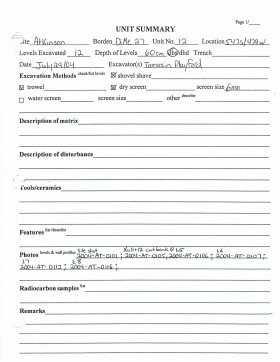
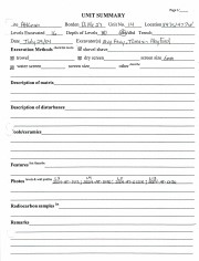
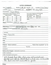
Record of excavation unit 12 at the Atkinson II site 2004.
Scope and Content
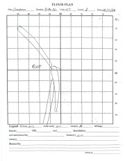
Site excavation records of excavation units may include: level summaries, floor plans, feature sheets, wall profiles, unit summaries and any other additional information relating to the unit.
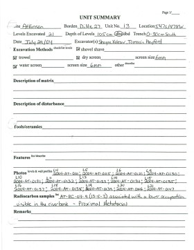
Record of excavation unit 13 at the Atkinson II site 2004.
Scope and Content
Site excavation records of excavation units may include: level summaries, floor plans, feature sheets, wall profiles, unit summaries and any other additional information relating to the unit.
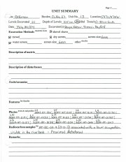
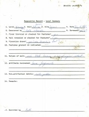
Record of excavation unit 14 at the Atkinson II site 2004.
Scope and Content
Site excavation records of excavation units may include: level summaries, floor plans, feature sheets, wall profiles, unit summaries and any other additional information relating to the unit.
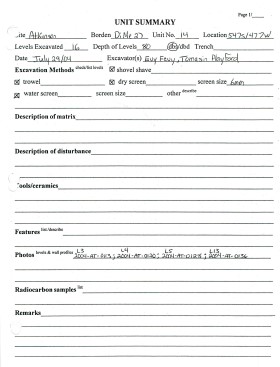
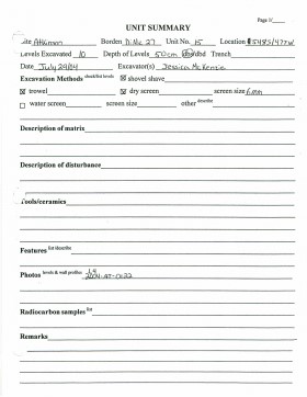
Record of excavation unit 15 at the Atkinson II site 2004.
Scope and Content
Site excavation records of excavation units may include: level summaries, floor plans, feature sheets, wall profiles, unit summaries and any other additional information relating to the unit.
The Graham site is a located adjacent to the Crepeele site towards the western end of the Crepeele locale. The Graham site was initially designated as a separate site early in the testing of the Crepeele locale due to what appeared to be a distinction between Early and Late Woodland ceramics. Subsequent testing has shown that this distinction was premature and that the cultural mosaic represented in the western section of the Crepeele locale may not readily separate in this manner. However, due to the records management that was already in place, the original separate designations have been retained.
Environment
Ground cover is a mosaic of aspen poplar groves and patches of mesic grass prairie. Excavation profiles indicate that this has been the situation since early precontact times, although as local climatic conditions change (primarily rainfall), the relative size of these areas and where they may have occurred also changed. The soil is aeolian sand sheet derived from delta outwash deposits along the western edge of glacial Lake Hind. The present topography is a variable dune landscape reworked by aeolian activity that creates a mosaic of microhabitats. These include forested patches in the lee of sand dunes grassland on the southern and western exposures and small damp lowlands that support balsam poplar, willows, red osier dogwood, high-bush cranberry and water birch. There is no permanent water source in the area although a small seasonal stream meanders through a damp lowland along the eastern margin of the Crepeele locale.
Excavations at the Graham site took place from 2004 to 2008. Analyses of the recoveries shows that, with two exceptions, all of the occupations that have been tested produced bison foetal bone. The presence of foetal bison is a strong indicator of wintering occupations...The absence of foetal in some area does not necessarily indicate warm season occupations since these excavation series are small and the absence could be due to sample error or perthotaxic factors, such as scavenging of the fragile bone by dogs or other carnivores.
From this evidence the Graham site has been interpreted as being primarily a wintering area. This is consistent with the lack of surface water (snow would serve as a substitute in winter) and the abundance of wood for fuel – a critical requirement for winter occupation. Cultural occupations date from Mortlach circa 250 B.P to woodland circa 580 B.P.
Scope and Content
Sub-series has been divided into sub sub series including: Graham 2004, Graham 2005, Graham 2006 and Graham 2008
The Sarah site was chosen for excavation based on the results of the Casselman survey. The survey recovered significant amounts of faunal remains, some ceramics and lithics from the test pits. Excavations took place in 2003 at Crepeele West (Units 1-5) and Crepeele East (Units 6-9). The site was subsequently renamed the Sarah site DiMe-28. In 2004 another 9 units were excavated (Units 10-18).
Based on the recoveries it was determined that the Sarah site is a stratified site with woodland ceramics in the upper occupation and late woodland points in both of the upper occupations. These upper occupations produced abundant bison bone including foetal bone. The lower occupations produced less bone and no foetal bone, although absence of foetal bone in the lower occupations does not necessarily indicate a warm season occupation. This could be due to sample error or perthotaxic factors such as scavenging of the fragile bone by dogs or other carnivores.
The dates from the Sarah site include 550+/-40 B.P.; 1430+/-80 B.P; 2810+/-80 B.P.; 3120+/-130 B.P. The lower occupations did not yield any diagnostic materials although debitage was abundant. These occupations were most productive at the edge of the large sand dune at the southern edge of the excavations. It is assumed that the major portion of these occupations have been overridden by the dune in the past 3000 years. Heavy earthmoving equipment would be required to remove this overburden which limits the possibility of future excavation.
Environment
The Sarah site is a large area located at the eastern end of the Crepeele locale. Ground cover is a mosaic of aspen poplar groves and patches of mesic grass prairie. Excavation profiles indicate that this has been the situation since early precontact times, although as local climatic conditions change (primarily rainfall), the relative size of these areas and where they may have occurred also changed. The soil is aeolian sand sheet derived from delta outwash deposits along the western edge of glacial Lake Hind. The present topography is a variable dune landscape reworked by aeolian activity that creates a mosaic of microhabitats. These include forested patches in the lee of sand dunes with grassland on the southern and western exposures and small damp lowlands that support balsam poplar, willows, red osier dogwood, high-bush cranberry and water birch. There is no permanent water source in the area although a small seasonal stream meanders through a damp lowland to the east of the Sarah site.
Scope and Content
Sub-series has been divided into sub sub series including: Sarah 2003 and Sarah 2004,
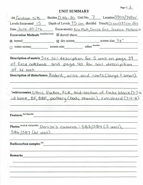
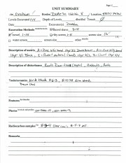
Record of site excavation unit 9 at Graham site 2004.
Scope and Content
Site records of excavation units may include: level summaries, floor plans, feature sheets, wall profiles, unit summaries and any other additional information relating to the unit.
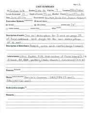
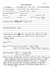
Record of site excavation unit 14 at Graham site 2004.
Scope and Content
Site records of excavation units may include: level summaries, floor plans, feature sheets, wall profiles, unit summaries and any other additional information relating to the unit.
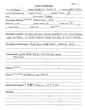
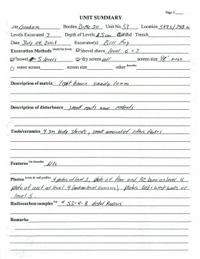
Record of site excavation unit 7 at Graham site 2006.
Scope and Content
Site records of excavation units may include: level summaries, floor plans, feature sheets, wall profiles, unit summaries and any other additional information relating to the unit.
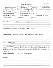
Record of site excavation unit 8 at Graham site 2006.
Scope and Content
Site records of excavation units may include: level summaries, floor plans, feature sheets, wall profiles, unit summaries and any other additional information relating to the unit.
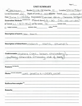
Record of site excavation unit 15 at Graham site 2006.
Scope and Content
Site records of excavation units may include: level summaries, floor plans, feature sheets, wall profiles, unit summaries and any other additional information relating to the unit.
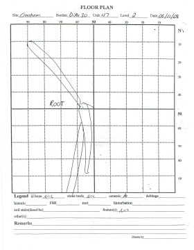
Record of site excavation unit 47 at Graham site 2008.
Scope and Content
Site records of excavation units may include: level summaries, floor plans, feature sheets, wall profiles, unit summaries and any other additional information relating to the unit.
Record of site excavation unit 48 at Graham site 2008.
Scope and Content
Site records of excavation units may include: level summaries, floor plans, feature sheets, wall profiles, unit summaries and any other additional information relating to the unit.
Record of site excavation unit 49 at Graham site 2008.
Scope and Content
Site records of excavation units may include: level summaries, floor plans, feature sheets, wall profiles, unit summaries and any other additional information relating to the unit.
Record of site excavation unit 53 at Graham site 2008.
Scope and Content
Site records of excavation units may include: level summaries, floor plans, feature sheets, wall profiles, unit summaries and any other additional information relating to the unit.
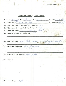
Record of site excavation unit 16 during the 1986 Lovstrom survey.
Scope and Content
Site records of excavation units may include: level summaries, floor plans, feature sheets, wall profiles, unit summaries and any other additional information relating to the unit.
Field journals have been scanned in multi-page PDF files. Artifact catalogues are PDF files in spreadsheet format. Photographs are in jpeg format.
History / Biographical
The Sarah site was initially chosen for excavation based on the results of the Casselman survey. The survey recovered significant amounts of faunal remains, some ceramics and lithics from the test pits. Excavations took place in 2003 at the Sarah site DiMe-28.
In 2004 further excavation took place as part of a Brandon University Archaeology Field School. Units 10 to 18 were excavated with Denise Ens as the instructor and James Graham teaching assistant.
Scope and Content
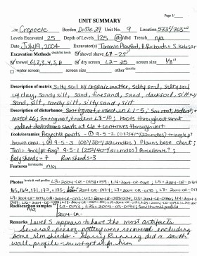
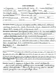
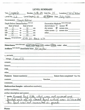
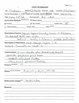
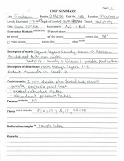
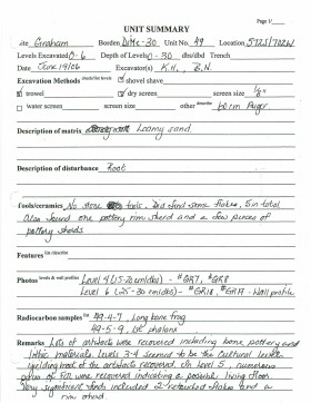
Sub-sub-sub series contains: Summary information of field methology, number and co-ordinates of excavations, personnel and their staff position; Field journalsare daily records of recoveries, features and activities at the site; Site records include excavation level and unit summaries, feature sheets, profiles; sample records and maps; Artifact catalogues are lists and identifications of all artifacts recovered; Photographs are of excavation units, features, the landscape and personnel.
Field journals have been scanned in multi-page PDF files. Artifact catalogues are PDF files in spreadsheet format. Photographs are in jpeg format.
History / Biographical
Graham units 9 and 14 were excavated with the Crepeele site in 2004 and were reassigned to the Graham site DiMe-30 keeping the same unit numbers. Tomasin Playford was crew chief in 2004.
The Graham site was initially designated as a separate site early in the testing of the Crepeele locale due to what appeared to be a distinction between Early and Late Woodland ceramics. Subsequent testing has shown that this distinction was premature and that the cultural mosaic represented in the western section of the Crepeele locale does not readily separate in this manner.
Scope and Content
Sub-sub-sub series contains: Summary information of field methology, number and co-ordinates of excavations, personnel and their staff position; Field journalsare daily records of recoveries, features and activities at the site; Site records include excavation level and unit summaries, feature sheets, profiles; sample records and maps; Artifact catalogues are lists and identifications of all artifacts recovered; Photographs are of excavation units, features, the landscape and personnel.
Field journals have been scanned in multi-page PDF files. Artifact catalogues are PDF files in spreadsheet format. Photographs are in jpeg format.
History / Biographical
The Graham site is located south of the Crepeele site. Due to the close proximity the Graham and Crepeele sites have both been the site of the Brandon University Archaeological Field School.
In 2006 a small Brandon University Archaeology Field School was conducted at the Graham site. Four excavations (XU 7, 8 15 & 16) were completed with Denise Ens Instructor and Jessica MacKenzie Teaching Assistant.
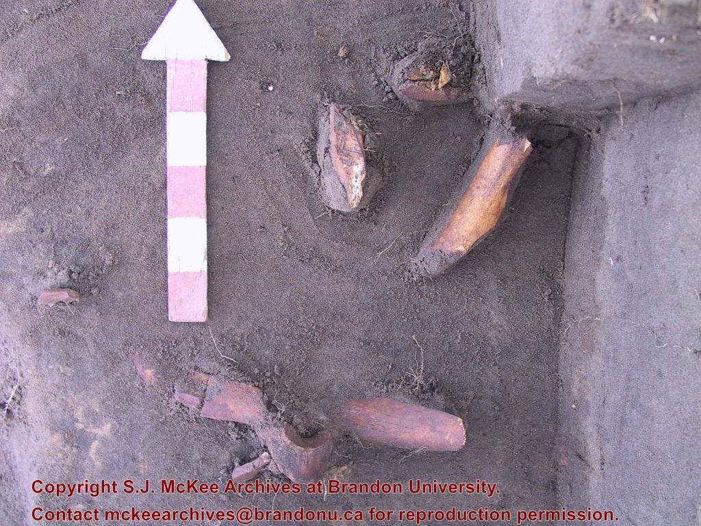
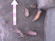
Recoveries included faunal (mostly bison), lithics and ceramics
The Graham site was initially designated as a separate site early in the testing of the Crepeele locale due to what appeared to be a distinction between Early and Late Woodland ceramics. Subsequent testing has shown that this distinction was premature and that the cultural mosaic represented in the western section of the Crepeele locale does not readily separate in this manner.
Scope and Content
Sub-sub-sub series contains: Summary information of field methology, number and co-ordinates of excavations, personnel and their staff position; Field journalsare daily records of recoveries, features and activities at the site; Site records include excavation level and unit summaries, feature sheets, profiles; sample records and maps; Artifact catalogues are lists and identifications of all artifacts recovered; Photographs are of excavation units, features, the landscape and personnel.
