The Lovstrom locale first came to the attention of Dr. Nicholson through conversations with landowners Mr. and Mrs. Herb Lovstrom in 1985. Lovstrom is a multi-component archaeological locale located 25km south of Brandon overlooking the Souris River channel. The landowner’s surface collection and the presence of bone and artifacts in a cultivated field indicated the presence of one or more sites.
Limited testing was conducted in 1985 and 1986, followed by major excavations in 1987, 1988 and 1991. Eight sites of block excavations with a total of 132 1m2 excavation units were completed. The locale area extends approximately 500m north from the edge of the Souris Valley escarpment and over 200m east from the Jock’s Creek escarpment.
Physical and biological environment As has been noted above, the locale is bounded on the south by the Souris channel and on the west by the incised channel of Jock’s Creek and a till plain extends to the north and the east. This plain is characterized by buff colored glacial till with numerous rocks embedded in the surface. Surrounding these rocky knolls are dark-soil hollows where the various cultural occupations are found. The depth of the topsoil layer suggests a long term grassland cover with the present oak forest likely developing in historic times due to the elimination of bison grazing and the controlling of prairie fires in late historic times. A small cleared patch of farmland is found within the boundaries of the locale area. This area has provided a substantial surface collection of artifacts.
Present vegetation in the area is a mosaic of aspen/oak forest groves and mesic grass prairie that includes introduced species such as brome grass. In poorly drained areas, willow and red osier dogwood are present. The Lovstrom locale is found in a forested area dominated by oak with an under story of saskatoon, chokecherry, pin cherry, and hazelnut brush. Poison ivy is abundant as well as sarsaparilla.
The major faunal resources in Precontact times would have been bison, with elk and mule deer playing a minor role. Antelope may have been present also. Small animals included snowshoe hare, cottontails, porcupines and beaver. Canids, including wolf, coyote, fox and domesticated dog were present, as well as mustelids such as badger, mink, and weasel. Fragments from a fisher were also recovered in the excavations.
Summation.
The Lovstrom locale has eight sites. The sites were designated and excavated as Blocks A, B, C, D, E, F, G and H. Many of the sites are multi-occupations.
The Vickers materials are primarily confined to Blocks D, E, F, G and H. Vickers Focus materials overlie Blackduck/Duck Bay materials. Blackduck and Duck Bay materials are found in the lower levels of all excavation blocks and in most test units. The Vickers occupations at the Lovstrom locale, based upon ceramic wares and an overlapping of C14 dates, appear to have been contemporary with the Lowton type site to the east, near Belmont. A small protohistoric occupation was identified overlying part of Block D. Faunal remains are abundant with bison clearly dominating the assemblages. Lesser amounts of canid are present as well as small mammals including beaver, hare and mustelids. Small amounts of avian species are also present.
Publications
Nicholson, B.A.
2011 The Role of Pocket Gophers (Thomomys talpoides) in Restructuring Stratigraphic Relationships at the Lovstrom Site. Canadian Journal of Archaeology 35:323-331.
Nicholson, Bev, Scott Hamilton, Matthew Boyd and Sylvia Nicholson
2008 A Late Plains Woodland Adaptive Strategy in the Northern Parklands: the Vickers Focus Forager-Horticulturists. Invited Paper for Papers in Northeastern Plains Prehistory, eds. Michael G. Michlovic and Dennis L. Toom, North Dakota Journal of Archaeology Vol. 8:19-34.
Nicholson, Bev and Scott Hamilton
2001 Cultural Continuity and Changing Subsistence Strategies During the Late Precontact Period in Southwestern Manitoba. Canadian Journal of Archaeology 25:53-73.
Nicholson, Bev
1996 Plains Woodland Influx and the Blackduck Exodus in South-Western Manitoba During the Late Precontact Period. Manitoba Archaeological Journal 6(1):69-85.
Nicholson, Bev and Mary Malainey
1991 Report on the 1991 Field School Excavations at the Lovstrom Site (DjLx-1), Southwestern Manitoba. Manitoba Archaeological Journal 1(2): 51-93.
Nicholson, Bev and Jane Gibson
1990-91 Lovstrom Site Field Report, 1987 Excavations. Saskatchewan Archaeology 11&12:46-68.
Nicholson, Bev and Ian Kuiijt
1990 Field Report and Interpretations of the 1988 Archaeological Excavations at the Lovstrom Site (DjLx-1) in Southwestern Manitoba. North Dakota Journal of Archaeology 4:166-205.
Nicholson, Bev
1990 Ceramic Affiliations and the Case for Incipient Horticulture in Southwestern Manitoba. Canadian Journal of Archaeology 14:33-60.
Nicholson, Bev
1986 The Lovstrom Site: Culture Contact in Prehistory. Manitoba Archaeological Quarterly 10(1):35-71.
Scope and Content
The Series has been divided into nine sub-series, including (1) Survey (2) Block A; (3) Block B (4) Block C; (5) Block D; (6) Block E; (7) Block F; (8) Block G; (9) Block H
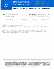
Radiocarbon date reports have been scanned in multi-page PDF files.
History / Biographical
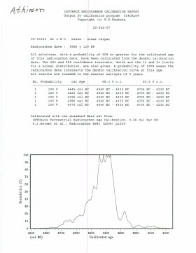
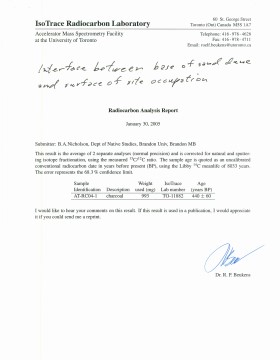
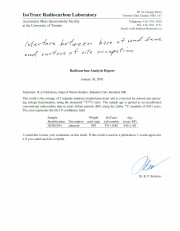
North Lauder Radiocarbon Date report by IsoTrace Laboratory for Atkinson site #TO-13365.
Radiocarbon dating
The technique of radiocarbon dating was developed by Willard Libby and his colleagues at the University of Chicago in 1949.
Radiocarbon dating is used to estimate the age of organic remains from archaeological sites. Organic matter has a radioactive form of carbon (C14) that begins to decay upon death. C14 decays at a steady, known rate of a half life of 5,730 years. The technique is useful for material up to 50,000 years. Fluctuations of C14 in the atmosphere can affect results so dates are calibrated against dendrochronology. Radiocarbon dates are calibrated to calendar years.
Dates are reported in radiocarbon years or Before Present. Before Present refers to dates before 1950. The introduction of massive amounts of C14, due to atomic bomb and surface testing of atomic weapons, has widely increased the standard deviation on all dates after A.D. 1700 causing these dates to be unreliable.
Accelerated mass spectrometry can more accurately measure C14 with smaller samples and can date materials to 80,000 years.
Scope and Content
Sub sub series contains radiocarbon dates from: Atkinson site and Flintstone Hill.
9.46 m textual records; 1919 photographs & graphics
History / Biographical
Brandon, Manitoba was incorporated as a city in 1881. In 1882, led by Charles Whitehead and a small Board of Directors that included J.W. Vantassel, Charles Pilling, George Halse, J.E. Smith, William Johnson, R.T. Evans, and Thomas Lockhart, it was decided to hold an agricultural exhibition. These men were all involved in the farm business in one way or another, and they wanted an opportunity to help residents realize the agricultural potential of the region. In October of that year, the fledgling community held its first agricultural exhibition . The fair was held in downtown Brandon at what was known as “Market Square.” Market Square was two acres of land located on Princess Avenue between Eighth and Ninth Streets. Due to poor weather, and the fact that not many people were ready to show animals and grain, there was a relatively small turnout. The following year was much improved. There were 730 entries into the exhibition. By 1884, the Board of Directors of the Brandon Agricultural Society, which was in charge of the exhibition, realized that they were in poor financial shape, to the point of being personally out of pocket. It was realized that October was not the best time for farmers to be leaving their farms to go to an exhibition. In 1888, it was decided to move the exhibition to the summer time, when it was much easier for people to attend.
The first Brandon Summer Fair was held in July 1889, and it was a resounding success. The Board of Directors had added many items of interest to appeal to the entire public, not just agricultural people. In 1892, the Western Agricultural and Arts Association (WAAA) was formally established to take over duties from the Brandon Agricultural Society. However, it was not until 1897 that the WAAA held its first meeting. There is no explanation as to why there is a five year gap between the formation and the first meeting of this organization. 1897 was the turning point of the Brandon Exhibition. The fair was now firmly established in Brandon, and the Board of Directors was instrumental in ensuring that it remained so. This was done by petitioning to both the municipal and provincial governments for grant money. As well, the Board booked midway and grandstand acts that would bring the city dwellers to the agricultural exhibition.
There were also early attempts at holding an agricultural exhibition in the winter. The first such attempt was in 1884. There was also a Spring Stallion show held in 1891. By 1904, however, a petition by J.D. McGregor had gone out to formally establish a winter exhibition. This effort also failed, but by 1906, it was decided by businessmen, politicians, and farm representatives in Brandon, including McGregor, to organize a winter fair. Rather than seeing this new fair as competition, the Board of Directors of the summer fair felt that it would complement their exhibition. The new fair would remain primarily agricultural. The first winter fair was held in 1906. While the two fairs were not amalgamated, they did share the same secretary-manager. The secretary-manager was responsible for the day to day management of the fair, as well as keeping track of meetings and decisions reached by the various fair boards and committees. In 1907, the Brandon Winter Fair and Livestock Association (BWFLA) was formed to act primarily as a land-holding joint stock company. The following year the Provincial Winter Fair and Fat Stock Association (PWFFSA), an entirely separate organization from the BWFLA, was formed to manage the activities of the winter fair. The PWFFSA name was soon changed to the Manitoba Winter Fair and Fat Stock Association (MWFFSA).
By 1906, Brandon could boast two full size exhibitions, one in the summer and one in the late winter, both of which were considered to be premiere events. In 1908, the Brandon summer fair was renamed the Inter-Provincial Exhibition, and in 1912 it held it’s first Traveller’s Day, an event which would soon become an important addition to the fair and is still in existence today. It is thought that the name “Traveller’s Day” came from the fact that it was held on a Saturday, a day when many people could travel to Brandon for the exhibition.
In 1913, Brandon was bestowed with the honour of hosting the Dominion Exhibition. This was a national exhibition sponsored by the federal government. It was held in a different city every year. There were several cities vying for the 1913 Dominion Exhibition, but it was Brandon that impressed the sponsors the most. With the government funds received for this honour, the Board of Directors supervised the building of a new grandstand, display buildings, and racetrack, as well as the general expansion and improvements to the fairgrounds.
In the spring of 1912, it was decided by the Board of Directors of the winter fair that the facilities they were currently housed in were inadequate for their needs. The mayor and city clerk of Brandon went to the provincial legislature in order to request that there be an amendment added to the Brandon city charter. This amendment would allow the city to guarantee bonds issued by the winter fair board to help pay for the construction of a new facility. This request was granted, and a $70 000 addition was built next to the original winter fair building. The new building was opened in 1913.
Throughout the First World War, both the winter fair and Provincial Exhibition buildings were used for the war effort. There was one distinct difference however. The summer fair Board was able to negotiate a deal with the army that enabled it to reclaim the fair buildings during fair week. The winter fair, however, had to give up the idea of holding fairs in 1915 and 1916. It was not until 1917, that the winter fair was able to resume.
During this time, due to the financial problems that had beset the winter fair, the two exhibitions considered amalgamation. The Board of Directors of the winter fair felt that because they were the smaller of the two fairs, their interests would be swallowed up by the summer fair. The winter fair withdrew from the negotiations to amalgamate. With this rather sudden turn of events, the Board of Directors of the summer fair petitioned the government to be allowed to incorporate. This was granted, and in 1920, the WAAA was incorporated as the Provincial Exhibition of Manitoba. From 1920, the summer fair was officially known as the Provincial Exhibition of Manitoba. This was the first time that the summer fair was incorporated, and received the “status and financial assistance” that came with incorporation.
More problems beset the winter fair in the 1920s. In 1920, a fire burned down the winter fair pavilion, located at the south end of the winter fair buildings, and caused the Board to cancel the 1921 winter fair. It was not until 1922, that a new building was completed. By 1929, both fairs were well regarded throughout Canada. In 1929, a decade long Depression hit the west. While many fairs closed during this time, Brandon struggled to keep its open. The Directors of both fairs felt that the agricultural shows “encouraged excellence at a time when faith and enthusiasm were at a low ebb.” The summer fair proved to be quite successful during the Depression, likely as a result of the few moments one was able to forget one’s troubles while there. The winter fair was not quite as successful, although both fairs received government grants and work relief projects. There was little new entertainment in these exhibitions.
There were changes about to manifest themselves at the summer fair, however. While the winter fair had representatives from various associations on its Board of Directors, the summer fair Board of Directors was a small close-knit group of men. Citizens saw entry into this elite group as elusive and difficult. To ward off the possibility of the Board becoming a “self-sustaining clique,” that only chose Directors from within, it was decided by several citizens to try and elect some new blood into the fair Board. In 1933, there was a general election for the Board. Instead of the usual men shuffling positions, there were forty-four nominations for the twenty positions. When the voting was all over, seven new men sat on the Board. Despite some inner rumblings, especially on the summer fair Board over the next few years, both exhibitions survived the Depression.
During the Second World War the fairs once again were forced to operate under adversity. Once again, the buildings were requisitioned for the army, although they were released during fair week. The summer fair was forced to make several concessions, and the winter fair was relocated to the summer fair grounds for the duration.
The winter fair did not survive the Second World War intact. Due to financial reasons, in December of 1945, the Board of Directors turned the winter fair buildings over to the City of Brandon. By 1946, the BWFLA, which was the joint-stock land holding company, had ceased operations because the city now controlled the winter fair land and buildings.
The next fifteen years would be a time of rebuilding for both of Brandon’s exhibitions. Children especially were more active participants in the agricultural exhibitions. The summer fair continued to diversify and look for new ways of entertaining the public at large. The winter fair remained primarily agricultural. By the end of the 1950s the winter fair, which was used to struggling, was now both successful and stable; and the summer fair, a perennial success, was starting to fade.
By 1969, both the winter and summer fair Boards had realized that amalgamation was the best possible decision, both practically and financially, for the future of the two fairs. On 29 October, 1969, the two exhibitions amalgamated to become the Manitoba Exhibition Association. The reconstituted Provincial Exhibition of Manitoba was now responsible for both the winter and summer fairs. A new building was erected on the summer fair grounds to house both of the exhibitions. On 2 April 1973, the Keystone Centre was officially opened at the winter fair, although it had been in use since October of the preceding year.
In 1970, Manitoba’s Centennial, it was decided that an organization in Manitoba would receive the title of “Royal,” as a way to celebrate the centennial. Although many organizations applied for the honour, it was the Brandon winter fair that received the accolades. The winter fair was bestowed with the title “Royal”, and became known as the Royal Manitoba Winter Fair.
In 1975, a third exhibition was added, this time a purely agricultural fall show known as the Agricultural Exhibition, or AgEx. This fair was partly organized on behalf of the cattle growers, who found that the summer and winter fairs did not give them adequate time and space to properly show their cattle. The return to a fall show, which had not existed since 1888, would be the return to a purely agricultural exhibition. This show was to be primarily a show and sale event. On 3 November 1975, the first AgEx was opened to resounding success.
The Provincial Exhibition of Manitoba, the Royal Manitoba Winter Fair and AgEx are all still in existence in Brandon. They are regarded as three of the most important events to take place annually in the city.
Custodial History
These files were housed with the Manitoba Exhibition Association until c1986 when they were transferred to the S.J. McKee Archives at Brandon University.
Scope and Content
The fonds consists of textual records and photographs comprised of the records from the three annual exhibitions that are held in Brandon, Manitoba: the Provincial Exhibition of Manitoba, the Royal Manitoba Winter Fair, and the Agricultural Exhibition (Ag-Ex). The textual records include prize lists, programs, minutes, financial, administrative files, original results, scrapbooks, tickets, news releases, contracts, by laws, documents as well as a miscellaneous section. There are approximately 1846 photographs that include scenes from these three exhibitions. These records provide a unique perspective on the development of agriculture and rural life in southwestern Manitoba. Fairs such as these have been and remain prime media of farm improvement, technological and scientific advancement in rural Canada, and the promoters of country living. These fairs also reflected the long tradition inherited from Britain and Europe of country fairs as centers of entertainment, social interchange and diversion. These records are a principal source of information about the most broadly based vocational, entertainment and social events held on an annual basis in southwestern Manitoba over the last century. The records are vital to academic research on agriculture or fairs, individual biography, or community history.
Notes
The RG 2 Provincial Exhibition of Manitoba Association finding aid was created by Karyn (Riedel) Taylor with the exception of Series 9 and the accompanying database, which were created by Donica Belisle. This finding aid was created in August 1999.
Researchers are responsible for observing Canadian copyright restrictions.
Finding Aid
Available
Storage Location
RG 2 Provincial Exhibition of Manitoba Association fonds
Storage Range
RG 2 Provincial Exhibition of Manitoba Association fonds
Related Material
Additional records regarding the Provincial Exhibition of Manitoba, the Royal Manitoba Winter Fair, and AgEx are housed at the Provincial Exhibition of Manitoba Association offices. To gain access to these records, it is necessary to contact the general manager of the Provincial Exhibition of Manitoba Association.
Arrangement
The fonds is divided into sous-fonds by exhibition. There is a Provincial Exhibition sous-fonds, a Royal Manitoba Winter Fair sous-fonds, an Ag-Ex sous-fonds, and a Miscellaneous sous-fonds that holds information that could not be easily broken down into one exhibition. The arrangement is as follows:
RG 2 Provincial Exhibition Association of Manitoba fonds
RG2SF1 Provincial Exhibition of Manitoba
1.1 Documents
1.2 Minutes
1.3 Financial Records
1.4 Administrative Files
1.5 Prize Lists and Programs
1.6 News Releases
1.7 Original Results
1.8 Tickets
1.9 Photographs
1.10 Scrapbooks
1.11 Miscellaneous
RG2SF2 Royal Manitoba Winter Fair
2.1 Documents
2.2 Minutes
2.3 Financial Records
2.4 Administrative Files
2.5 Prize Lists and Programs
2.6 News Releases
2.7 Original Results
2.8 Tickets
2.9 Photographs
2.10 Scrapbooks
2.11 Miscellaneous
RG2SF3 AgEx
3.4 Administrative Files
3.5 Prize Lists and Programs
3.6 News Releases
3.7 Original Results
3.9 Photographs
RG2SF4 Miscellaneous
4.1 Documents
4.2 Minutes
4.3 Financial Records
4.4 Administrative Files
4.9 Photographs
4.10 Scrapbooks
4.11 Miscellaneous
Radiocarbon date reports have been scanned in multi-page PDF files.
History / Biographical
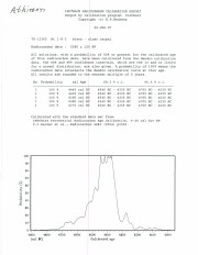
North Lauder Radiocarbon Date report by IsoTrace Laboratory for Atkinson site #TO-10640.
Radiocarbon dating
The technique of radiocarbon dating was developed by Willard Libby and his colleagues at the University of Chicago in 1949.
Radiocarbon dating is used to estimate the age of organic remains from archaeological sites. Organic matter has a radioactive form of carbon (C14) that begins to decay upon death. C14 decays at a steady, known rate of a half life of 5,730 years. The technique is useful for material up to 50,000 years. Fluctuations of C14 in the atmosphere can affect results so dates are calibrated against dendrochronology. Radiocarbon dates are calibrated to calendar years.
Dates are reported in radiocarbon years or Before Present. Before Present refers to dates before 1950. The introduction of massive amounts of C14, due to atomic bomb and surface testing of atomic weapons, has widely increased the standard deviation on all dates after A.D. 1700 causing these dates to be unreliable.
Accelerated mass spectrometry can more accurately measure C14 with smaller samples and can date materials to 80,000 years.
Scope and Content
Sub sub series contains radiocarbon dates from: Atkinson site and Flintstone Hill.
ARCH 2: North Lauder Locale
The North Lauder locale has a long archaeological and geological history that is important for understanding the forces that shaped the region. Archaeological research in the locale shows that the area has been occupied by humans for at least the past 6,500 years. Environmental forces provided an area of diverse resources that attracted early peoples.
Environment of the Lauder Sandhills
The North Lauder locale is part of the greater Lauder Sandhills area. The glaciers that covered this region began to recede approximately 11,000 years ago leaving a large lake known as glacial Lake Hind. The Souris River, the Lauder Sandhills and the Oak Lake Aquifer are remnants of the environmental and geological forces that shaped the region.
The Lauder Sandhills region is characterized by a landscape of sand sheets and stabilized sand dunes interspersed with a variety of wetlands. This complex topographic and hydrological situation favoured the development of an island mosaic of mixed forest, wetland and meadow, surrounded by mixed grass prairie. The result was a large, isolated ecotone which provided a rich variety of subsistence resources for hunter-gatherers.
Research in the Lauder Sandhills
Archaeologists from Brandon University have been conducting research in the Lauder Sandhills since 1991. Research in the North Lauder locale has focused on the Atkinson site, a 6,500 year old hunter-gatherer site and Flintstone Hill.
The Atkinson site
The Atkinson site is one of the oldest excavated sites in Manitoba and has been Radiocarbon dated to 6,500 years before present. The Atkinson site is located on the bank of the Souris River and was discovered when a hearth (fire pit) was seen eroding out of the bank. Based on the date of the site and the kind of lithics (stone tools) present it is considered a Gowen occupation. The Atkinson site is evidence that bison hunters were active on the northern plains at a very early date. Similar sites have also been found on the High Plains in the U.S. and are referred to as the Mummy Cave Complex.
The Atkinson Site is of great importance as it is the first undisturbed site of this type to be excavated in Manitoba and extends the range of these sites south and east from the type-sites in central Saskatchewan.
Flintstone Hill
The geomorphology of the glacial Lake Hind Basin over the past 11,000 years is known primarily through the study of a cut bank along the Souris River. Flint Stone Hill contains the most complete stratigraphic record for the post-glacial period on the northern plains. The site has been extensively studied by geoarchaeologists, geologists and paleoenvironmentalists over many years and their findings have contributed to our understanding of the region.
The North Lauder locale Borden designations of Atkinson site DiMe-27 and Flintstone Hill site DiMe-26.
Borden System
Archaeological sites in Canada are identified by the Borden system, which is a uniform site designation system. The country is divided into grids based on latitude and longitude in blocks of 10 x 20 minutes. The first 4 letters indicate the block and the following numbers indicate the actual site. For example the area of the Lauder Sandhills in southwestern Manitoba is identified by the letters DM and the North Lauder locale within that area is DiMe. The Atkinson site is DiMe-27 and the Flintstone Hill site DiMe-26. As new sites are discovered they will be numbered sequentially.
Scope and Content
The Series has been divided into two sub-series, including (1) Atkinson site DiMe-27 and Flintstone Hill site DiMe-26.
See sub sub series RG 6 14.5.3 The Quill for History/Bio information.
The duplicates retained were chosen to provide an illustration of the changing content and format of the Quill from 1930-1975. They are primarliy for display purposes, as microfilm copies are available for researchers. The original copies of the Quill provide an archival record, but these may be used only under most unusal circumstances. Additional duplicates were culled.
Custodial History
See sub sub series RG 6 14.5.3 The Quill for Custodial history.
Scope and Content
The McKee Archives holds duplicate editions of The Quill for the following years:1930-1931, 1933 to 1942, 1946 to 1949, 1955 to 1959, 1962-1963 and 1975-1976.
The microfilm copies of the Quill cover the period from September 1930 to March 1972, and are located with the originals. The Archives holds both positive and negative versions of the microfilmed editions. The microfilming was made possible through a grant from Dr. Thomas McLeod (Brandon College 1940) in 1999.
Notes
The Quill duplicates and special editions are stored in the same box.
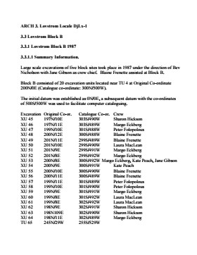
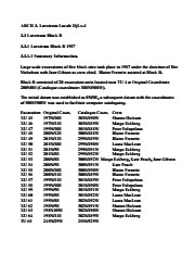
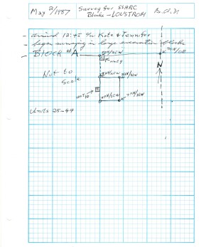
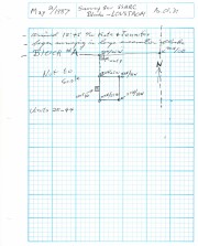
Block B consisted of 20 contiguous 1m2 units excavated to 30 cm below surface. (except unit 58 which was excavated to 35 cm bs to obtain extended soil profile). The block is situated in recent oak and poplar forest at the head of a ravine leading to Jock’s Creek, adjacent to an area cleared for market gardening. As was the case with Block A, the understory is heavily overgrown with hazelnut, chokecherry, saskatoon, and a poison ivy/sarsaparilla ground cover.
The soil levels below the sod in Block B consisted of a black, silty, and gritty loam layer from 5 cm to 23 cm below surface, a yellow and sandy clay from 23 cm to 30 cm below surface, and glacial till at 30 cm below surface. As in Block A, limestone cobbles were found throughout the occupation level around the bone. It is evident that bioturbation – primarily tree roots and rodent burrowing – have significantly altered patterns of original deposition of lithics, ceramics and small bone.
The faunal layer lay close to the surface, situated entirely in the black loam 5 cm – 23 cm below surface. The 23 cm depth also marked the end of the dark silty loam. At 10 cm below surface, a discernible patterning of the bone appeared. Concentrations of bone in narrow rows ran in an irregular pattern from the northwest to the southeast part of the block. This pattern was most apparent in the north end of the block which is the highest point in the block. In the same 1m2 unit, patches of weathered, very poorly preserved bone would be found lying close to patches of well preserved bone. It is believed that this variability in preservation results from uneven rates of burial due to taphic activities of pocket gophers or other agents of bioturbation. The same pattern of uneven preservation occurs over much of the locale but is most evident in Block B.
Diagnostic lithics included eleven projectile points that were predominantly Plains or Prairie Side-notch types, but included two unnotched triangular points. Cord-wrapped impressed rim sherds and body sherds were recovered. The ceramics are variants of the Woodland Blackduck horizon.
RC dates: XU49 – 675/80 BP XU 59 – 705/75BP.
Scope and Content
Sub-sub-sub series contains: Summary information of field methology, number and co-ordinates of excavations, personnel and their staff position; Field journals are daily records of recoveries, features and activities at the site; Site records include excavation level and unit summaries, feature sheets, profiles; sample records and maps; Artifact catalogues are lists and identifications of all artifacts recovered; Photographs are of excavation units, features, the landscape and personnel.
Radiocarbon date reports have been scanned in multi-page PDF files.
History / Biographical
Crepeele locale Radiocarbon Dates. C14 report by IsoTrace Laboratory for Crepeele site 2005 XU 8.
From 2003 to 2008 field work took place at the Crepeele locale with 75 - 1m x1m units excavated.
To help establish the cultural sequence at the locale Radiocarbon dates were obtained from the three sites in the Crepeele locale.
Radiocarbon dating
The technique of radiocarbon dating was developed by Willard Libby and his colleagues at the University of Chicago in 1949.
Radiocarbon dating is used to estimate the age of organic remains from archaeological sites. Organic matter has a radioactive form of carbon (C14) that begins to decay upon death. C14 decays at a steady, known rate of a half life of 5,730 years. The technique is useful for material up to 50,000 years. Fluctuations of C14 in the atmosphere can affect results so dates are calibrated against dendrochronology. Radiocarbon dates are calibrated to calendar years.
Dates are reported in radiocarbon years or Before Present. Before Present refers to dates before 1950. The introduction of massive amounts of C14, due to atomic bomb and surface testing of atomic weapons, has widely increased the standard deviation on all dates after A.D. 1700 causing these dates to be unreliable.
Accelerated mass spectrometry can more accurately measure C14 with smaller samples and can date materials to 80,000 years.
Scope and Content
Sub sub series contains radiocarbon dates from: Crepeele, Sarah and Graham sites.
Radiocarbon date reports have been scanned in multi-page PDF files.
History / Biographical
Crepeele locale Radiocarbon Dates. C14 report by Beta Analytic Inc. for Crepeele site XU 48 and Graham site XU 54.
From 2003 to 2008 field work took place at the Crepeele locale with 75 - 1m x1m units excavated.
To help establish the cultural sequence at the locale Radiocarbon dates were obtained from the three sites in the Crepeele locale.
Radiocarbon dating
The technique of radiocarbon dating was developed by Willard Libby and his colleagues at the University of Chicago in 1949.
Radiocarbon dating is used to estimate the age of organic remains from archaeological sites. Organic matter has a radioactive form of carbon (C14) that begins to decay upon death. C14 decays at a steady, known rate of a half life of 5,730 years. The technique is useful for material up to 50,000 years. Fluctuations of C14 in the atmosphere can affect results so dates are calibrated against dendrochronology. Radiocarbon dates are calibrated to calendar years.
Dates are reported in radiocarbon years or Before Present. Before Present refers to dates before 1950. The introduction of massive amounts of C14, due to atomic bomb and surface testing of atomic weapons, has widely increased the standard deviation on all dates after A.D. 1700 causing these dates to be unreliable.
Accelerated mass spectrometry can more accurately measure C14 with smaller samples and can date materials to 80,000 years.
Scope and Content
Sub sub series contains radiocarbon dates from: Crepeele, Sarah and Graham sites.
Radiocarbon date reports have been scanned in multi-page PDF files.
History / Biographical
Crepeele locale Radiocarbon Dates. C14 report by Beta Analytic Inc. for Crepeele site XUs 8, 30, 50.
From 2003 to 2008 field work took place at the Crepeele locale with 75 - 1m x1m units excavated.
To help establish the cultural sequence at the locale Radiocarbon dates were obtained from the three sites in the Crepeele locale.
Radiocarbon dating
The technique of radiocarbon dating was developed by Willard Libby and his colleagues at the University of Chicago in 1949.
Radiocarbon dating is used to estimate the age of organic remains from archaeological sites. Organic matter has a radioactive form of carbon (C14) that begins to decay upon death. C14 decays at a steady, known rate of a half life of 5,730 years. The technique is useful for material up to 50,000 years. Fluctuations of C14 in the atmosphere can affect results so dates are calibrated against dendrochronology. Radiocarbon dates are calibrated to calendar years.
Dates are reported in radiocarbon years or Before Present. Before Present refers to dates before 1950. The introduction of massive amounts of C14, due to atomic bomb and surface testing of atomic weapons, has widely increased the standard deviation on all dates after A.D. 1700 causing these dates to be unreliable.
Accelerated mass spectrometry can more accurately measure C14 with smaller samples and can date materials to 80,000 years.
Scope and Content
Sub sub series contains radiocarbon dates from: Crepeele, Sarah and Graham sites.
Radiocarbon date reports have been scanned in multi-page PDF files.
History / Biographical
Crepeele locale Radiocarbon Dates. C14 report by IsoTrace Analytic Laboratory for Sarah site XU17.
From 2003 to 2008 field work took place at the Crepeele locale. The Crepeele, Graham and Sarah sites were excavated with 75 - 1m x1m units excavated
To help establish the cultural sequence at the locale Radiocarbon dates were obtained from the three sites in the Crepeele locale.
Radiocarbon dating
The technique of radiocarbon dating was developed by Willard Libby and his colleagues at the University of Chicago in 1949.
Radiocarbon dating is used to estimate the age of organic remains from archaeological sites. Organic matter has a radioactive form of carbon (C14) that begins to decay upon death. C14 decays at a steady, known rate of a half life of 5,730 years. The technique is useful for material up to 50,000 years. Fluctuations of C14 in the atmosphere can affect results so dates are calibrated against dendrochronology. Radiocarbon dates are calibrated to calendar years.
Dates are reported in radiocarbon years or Before Present. Before Present refers to dates before 1950. The introduction of massive amounts of C14, due to atomic bomb and surface testing of atomic weapons, has widely increased the standard deviation on all dates after A.D. 1700 causing these dates to be unreliable.
Accelerated mass spectrometry can more accurately measure C14 with smaller samples and can date materials to 80,000 years.
Scope and Content
Sub sub series contains radiocarbon dates from: Crepeele, Sarah and Graham sites.
Radiocarbon date reports have been scanned in multi-page PDF files.
History / Biographical
Crepeele locale Radiocarbon Dates. C14 report by IsoTrace Analytic Laboratory for Graham site XUs 5 and 8.
From 2003 to 2008 field work took place at the Crepeele locale. The Crepeele, Graham and Sarah sites were excavated with 75 - 1m x1m units excavated
To help establish the cultural sequence at the locale Radiocarbon dates were obtained from the three sites in the Crepeele locale.
Radiocarbon dating
The technique of radiocarbon dating was developed by Willard Libby and his colleagues at the University of Chicago in 1949.
Radiocarbon dating is used to estimate the age of organic remains from archaeological sites. Organic matter has a radioactive form of carbon (C14) that begins to decay upon death. C14 decays at a steady, known rate of a half life of 5,730 years. The technique is useful for material up to 50,000 years. Fluctuations of C14 in the atmosphere can affect results so dates are calibrated against dendrochronology. Radiocarbon dates are calibrated to calendar years.
Dates are reported in radiocarbon years or Before Present. Before Present refers to dates before 1950. The introduction of massive amounts of C14, due to atomic bomb and surface testing of atomic weapons, has widely increased the standard deviation on all dates after A.D. 1700 causing these dates to be unreliable.
Accelerated mass spectrometry can more accurately measure C14 with smaller samples and can date materials to 80,000 years.
Scope and Content
Sub sub series contains radiocarbon dates from: Crepeele, Sarah and Graham sites.
Field journals have been scanned in multi-page PDF files. Artifact catalogues are PDF files in spreadsheet format. Photographs are in jpeg format.
History / Biographical
Large scale excavations of five block sites took place in 1987 under the direction of Bev Nicholson with Jane Gibson as crew chief. Block B consisted of 21 excavation units.
Scope and Content
Sub-sub-sub series contains: Summary information of field methology, number and co-ordinates of excavations, personnel and their staff position.
Radiocarbon date reports have been scanned in multi-page PDF files.
History / Biographical
North Lauder Radiocarbon Date report by IsoTrace Laboratory for Atkinson II site #TO-11882.
Radiocarbon dating
The technique of radiocarbon dating was developed by Willard Libby and his colleagues at the University of Chicago in 1949.
Radiocarbon dating is used to estimate the age of organic remains from archaeological sites. Organic matter has a radioactive form of carbon (C14) that begins to decay upon death. C14 decays at a steady, known rate of a half life of 5,730 years. The technique is useful for material up to 50,000 years. Fluctuations of C14 in the atmosphere can affect results so dates are calibrated against dendrochronology. Radiocarbon dates are calibrated to calendar years.
Dates are reported in radiocarbon years or Before Present. Before Present refers to dates before 1950. The introduction of massive amounts of C14, due to atomic bomb and surface testing of atomic weapons, has widely increased the standard deviation on all dates after A.D. 1700 causing these dates to be unreliable.
Accelerated mass spectrometry can more accurately measure C14 with smaller samples and can date materials to 80,000 years.
Scope and Content
Sub sub series contains radiocarbon dates from: Atkinson site and Flintstone Hill.
Radiocarbon date reports have been scanned in multi-page PDF files.
History / Biographical
North Lauder Radiocarbon Date report by Beta Analytic Inc. for Flintstone Hill #109529 and #109530.
Radiocarbon dating
The technique of radiocarbon dating was developed by Willard Libby and his colleagues at the University of Chicago in 1949.
Radiocarbon dating is used to estimate the age of organic remains from archaeological sites. Organic matter has a radioactive form of carbon (C14) that begins to decay upon death. C14 decays at a steady, known rate of a half life of 5,730 years. The technique is useful for material up to 50,000 years. Fluctuations of C14 in the atmosphere can affect results so dates are calibrated against dendrochronology. Radiocarbon dates are calibrated to calendar years.
Dates are reported in radiocarbon years or Before Present. Before Present refers to dates before 1950. The introduction of massive amounts of C14, due to atomic bomb and surface testing of atomic weapons, has widely increased the standard deviation on all dates after A.D. 1700 causing these dates to be unreliable.
Accelerated mass spectrometry can more accurately measure C14 with smaller samples and can date materials to 80,000 years.
Scope and Content
Sub sub series contains radiocarbon dates from: Atkinson site and Flintstone Hill.
Radiocarbon date reports have been scanned in multi-page PDF files.
History / Biographical
North Lauder Radiocarbon Date report by Beta Analytic Inc. for Flintstone Hill #111142 and #111143.
Radiocarbon dating
The technique of radiocarbon dating was developed by Willard Libby and his colleagues at the University of Chicago in 1949.
Radiocarbon dating is used to estimate the age of organic remains from archaeological sites. Organic matter has a radioactive form of carbon (C14) that begins to decay upon death. C14 decays at a steady, known rate of a half life of 5,730 years. The technique is useful for material up to 50,000 years. Fluctuations of C14 in the atmosphere can affect results so dates are calibrated against dendrochronology. Radiocarbon dates are calibrated to calendar years.
Dates are reported in radiocarbon years or Before Present. Before Present refers to dates before 1950. The introduction of massive amounts of C14, due to atomic bomb and surface testing of atomic weapons, has widely increased the standard deviation on all dates after A.D. 1700 causing these dates to be unreliable.
Accelerated mass spectrometry can more accurately measure C14 with smaller samples and can date materials to 80,000 years.
Scope and Content
Sub sub series contains radiocarbon dates from: Atkinson site and Flintstone Hill.
Radiocarbon date reports have been scanned in multi-page PDF files.
History / Biographical
North Lauder Radiocarbon Date report by Beta Analytic Inc. for Flintstone Hill #109900.
Radiocarbon dating
The technique of radiocarbon dating was developed by Willard Libby and his colleagues at the University of Chicago in 1949.
Radiocarbon dating is used to estimate the age of organic remains from archaeological sites. Organic matter has a radioactive form of carbon (C14) that begins to decay upon death. C14 decays at a steady, known rate of a half life of 5,730 years. The technique is useful for material up to 50,000 years. Fluctuations of C14 in the atmosphere can affect results so dates are calibrated against dendrochronology. Radiocarbon dates are calibrated to calendar years.
Dates are reported in radiocarbon years or Before Present. Before Present refers to dates before 1950. The introduction of massive amounts of C14, due to atomic bomb and surface testing of atomic weapons, has widely increased the standard deviation on all dates after A.D. 1700 causing these dates to be unreliable.
Accelerated mass spectrometry can more accurately measure C14 with smaller samples and can date materials to 80,000 years.
Scope and Content
Sub sub series contains radiocarbon dates from: Atkinson site and Flintstone Hill.
The Brandon University Teaching and Administration series is an artificially created collection. It contains the private papers of former Brandon University faculty and staff.
Scope and Content
The series has been divided into the following sub-series:
MG 3 1.1 Errol Black
MG 3 1.2 John Mallea
MG 3 1.3 John Tyman
MG 3 1.4 Lorelei Cederstrom
MG 3 1.5 William Morrison
MG 3 1.6 Ken Hanly
MG 3 1.7 John Welsted
MG 3 1.8 Henri Francq
MG 3 1.9 D.R. MacKay
MG 3 1.10 R.B. Inch
MG 3 1.11 Dale Lakevold
MG 3 1.12 George MacDowell
MG 3 1.13 Donald Wheeler
MG 3 1.14 W.Leland Clark
MG 3 1.15 Bev Nicholson
MG 3 1.16 John Everitt
MG 3 1.17 Michael Blanar
MG 3 1.18 Christy Henry
MG 3 1.19 May Yoh
MG 3 1.20 Francis Chaplin
MG 3 1.21 John Weldon Grant
MG 3 1.22 Harvey Young
MG 3 1.23 Lorne Watson
MG 3 1.24 Lawrence Jones
Storage Location
MG 3 Brandon University Teaching and Administration