Photograph shows the intersection of 10th Street and Princess Avenue, Brandon, Manitoba. View is facing northwest along west side of the 100-block of 10th Street. A stationary policeman/divider is at the centre of the intersection. Visible businesses include: Doig's, Plaza Shoe Shop, and Cambridge Clothes Shop. A horse-drawn sled is parked in front of Doig's store. The Olympia Block, Cecil Hotel, and CPR Station are visible in the background.
Photograph shows a street view of 10th Street facing north. There are many automobiles parked along the street and several pedestrians in summer dress are on the sidewalks and street. Visible business signs include: Hentzman & Co. Pianos (possibly belonging to J.J.H. McLean Co. Ltd.), the Strand Theatre, T & D Clothes, Campbell & Campbell, the CPR Station, and Bowling Alley and Billiards.
Notes
Part of "Souvenir of Brandon, Manitoba, Canada [viewbook], Printed by Photogelatine Engraving Co. Limited, Ottawa." Dates obtained from the Burchill's Music Store Henderson's Brandon City Directory listings (1927-1929). Writing on the front of the photograph reads: 10th St., looking north (C.P.R. Station at end of Street) Brandon, Man.
Photograph has been glued to a backing board that has warped over time
History / Biographical
On 16 November 1906, Manitoba was hit by a severe winter storm that began that Thursday evening and extended through the weekend. The Brandon Daily Sun ("Storm Extends Over a Large Territory," 17 Nov. 1906, 1) reported that rail and telegraph services had been disrupted, country roads were impassable, and business in town was at a stand still. Following the weekend, the daily reported the blizzard was one of the greatest in recent memory. CPR trains had been caught in drifts by Carberry and an express car had caught fire and was destroyed ("Worst Storm in Many Years," Brandon Daily Sun, 19 Nov. 1906, 1).
Scope and Content
Photograph shows street view of intersection of the 000 block of 8th Street and Rosser Avenue in the winter. Businesses on the east side of 8th Street from Pacific to Rosser Avenues are clearly visible and include: a Lunch Room (likely Aagaard's Lunch Counter), the Hotel Imperial Annex, Liverpool House (a boarding house), R.S. Thompson and Company Real Estate Office (Land Office), a barber shop (likely J. Coulter's), Frank Gowen photography studio. Fleming's Drug Store on the corner of 8th Street and Rosser Avenue has been replaced by the Bank of Hamilton. The Imperial Hotel is visible on the west side of 8th Street. The 8th Street Bridge is visible in the background. Men in winter coats and hats are crossing the street at the intersection. A horse-drawn sleigh is parked on 8th Street.
Notes
Writing on the front of the photograph matting reads: 340, after the storm November 1906. Page appears to be from a photo album. The photograph appears to be taken from the interior of a builing on the southwest corner of 8th Street and Rosser Avenue.
According to Russ Gourluck (Silver Screens on the Prairie, Winnipeg: Great Plains Publications, 2012, 26), the Orpheum Theatre was in operation from 1917 to 1920 when it then became the Willis Theatre.
Scope and Content
Postcard shows the 100 block of 10th Street facing north. The CPR train station can be seen at the end of 10th Street. The sign for the Rex Cafe is visible on the west side of 10th Street. On the east side of 10th Street, billboards for Campbell & Campbell furniture are visible as well as signs for Pianos and the Orpheum Theatre. Motorists and cyclists share the road. Street car tracks run the length of 10th Street.
Notes
Postcard was manufactured by T.B. [Tichnor Brothers, Inc., 1908-1987] Cambridge, Massachusetts.
Photographs have been glued to a backing board that has warped over time
Scope and Content
Photograph shows street view of north side of Rosser Avenue, primarily the 700 block. The Fleming Block, Beaubier Block and its Empire Hotel, A.M. Percival (a grocer), the Brandon Hardware Company (600 block), and the Arlington Hotel (500 block) are visible along the north side of the avenue. The Bank of Hamilton Building on the southeast corner of 8th Street and Rosser appears to be under construction. A sign in the second storey window above the main entrance reads: law office. The streets are muddy and a horse and buggy is traveling west on Rosser Avenue.
Notes
Writing on the front of the photograph matting reads: mud November 12, 1906, 339. The photograph appears to be taken from the interior of a builing on the southwest corner of 8th Street and Rosser Avenue. Page appears to be from a photo album.
Photographs have been glued to a backing board that has warped over time
History / Biographical
Photograph of possible Dakota from Sioux Valley in Brandon for the summer fair.
Scope and Content
Photograph shows street view of north side of Rosser Avenue, primarily the 700 block. Businesses visible in the Fleming Block include: Lowes Brothers Clothing, Robert Hall [Insurance Broker], Manitoba Farmers Hedge and Wire Fence Company. Businesses visible in the Beaubier Block include the Empire Hotel. Businesses east of the Empire Hotel are grocer A.M. Percival and the Brandon Hardware Company. A number of Aboriginal peoples are travelling on horseback west along Rosser Avenue as spectators look on.
Notes
Writing on the front of the photograph matting reads: 293. One photograph (20-2009.9) is glued above and two others are glued on the reverse side. Page appears to be from a photo album.
Photographs have been glued to a backing board that has warped over time
History / Biographical
Photograph of possible Dakota from Sioux Valley in Brandon for the summer fair.
Scope and Content
Photograph shows street view of north side of Rosser Avenue, primarily the 700 block. Businesses visible in the Beaubier Block include the Empire Hotel. Businesses east of the Empire Hotel are grocer A.M. Percival, the Brandon Hardware Company, and the Arlington Hotel. A number of Aboriginal peoples are driving horse and buggies east along Rosser Avenue as large numbers of spectators look on.
Notes
Writing on the front of the photograph matting reads: 298. One photograph (20-2009.79) is glued above, another (20-2009.81) adjacent. One other is glued on the reverse side. Page appears to be from a photo album.
Photograph shows the CPR Train Station on Pacific Avenue and 10th Street.
Notes
Part of "Souvenir of Brandon, Manitoba, Canada [viewbook], Printed by Photogelatine Engraving Co. Limited, Ottawa." Dates obtained from the Burchill's Music Store Henderson's Brandon City Directory listings (1927-1929). Writing on the front of the photograph reads: CPR Station, Brandon, Man.
Photographs have been glued to a backing board that has warped over time
History / Biographical
Photograph of possible Dakota from Sioux Valley in Brandon for the summer fair.
Scope and Content
Photograph shows street view of north side of Rosser Avenue, primarily the 700 block. Businesses visible in the Fleming Block include: Lowes Brothers Clothing, Robert Hall [Insurance Broker], Manitoba Farmers Hedge and Wire Fence Company. Businesses visible in the Beaubier Block include the Empire Hotel. Businesses east of the Empire Hotel are grocer A.M. Percival and the Brandon Hardware Company. A number of Aboriginal peoples are driving horse and carriages west along Rosser Avenue as spectators look on.
Notes
Writing on the front of the photograph matting reads: 295 July 1906. One photograph (20-2009.11) is glued above and two others are glued on the reverse side. Page appears to be from a photo album.
Photograph shows a southwest view of the Prince Edward Hotel and train station.
Notes
Part of "Souvenir of Brandon, Manitoba, Canada [viewbook], Printed by Photogelatine Engraving Co. Limited, Ottawa." Dates obtained from the Burchill's Music Store Henderson's Brandon City Directory listings (1927-1929). Writing on the front of the photograph reads: Prince Edward Hotel, Brandon, Man.
Photographs have been glued to a backing board that has warped over time
History / Biographical
Photograph of possible Dakota from Sioux Valley in Brandon for the summer fair.
Scope and Content
Photograph shows street view of north side of Rosser Avenue, primarily the 700 block. Businesses visible in the Fleming Block include: Lowes Brothers Clothing, Robert Hall [Insurance Broker], Manitoba Farmers Hedge and Wire Fence Company. Businesses visible in the Beaubier Block include the Empire Hotel. Businesses east of the Empire Hotel are grocer A.M. Percival and the Brandon Hardware Company. A number of Aboriginal peoples are driving horse and buggies west along Rosser Avenue as spectators look on.
Notes
Writing on the front of the photograph matting reads: 294 July 1906. One photograph (20-2009.10) is glued below and two others are glued on the reverse side. Page appears to be from a photo album.
Photograph shows the Brandon Wheat Market along Pacific Avenue on November 30, 1885. Farmers can be seen driving wagon teams loaded with bags of grain in line on Pacific Avenue from 10 Street to at least 7th Street. On the north side of Pacific Avenue the CPR Land Office and grain elevators are pictured. On the south side of Pacific Avenue, the general merchant/hardware store Bower, Blackburn, Mundell & Porter is situated on the corner of Pacific Avenue and 10th Street. A 10th Street sign is affixed to the merchants' store. On the east side of the general store, Edie House, the Grand View Hotel, and a Farmers' boarding and lodging house can be seen. Most of the buildings appear to be woodframed except for the Grand View, which is constructed of brick. Sidewalks appear to be in place on the south side of Pacific and snow dusts the streets. A baby swathed in winter clothing sits in a pram/baby carriage in front of the general store.
Notes
Writing on the front of the photograph reads: Novemeber 30th, 1885, Brandon Wheat Market
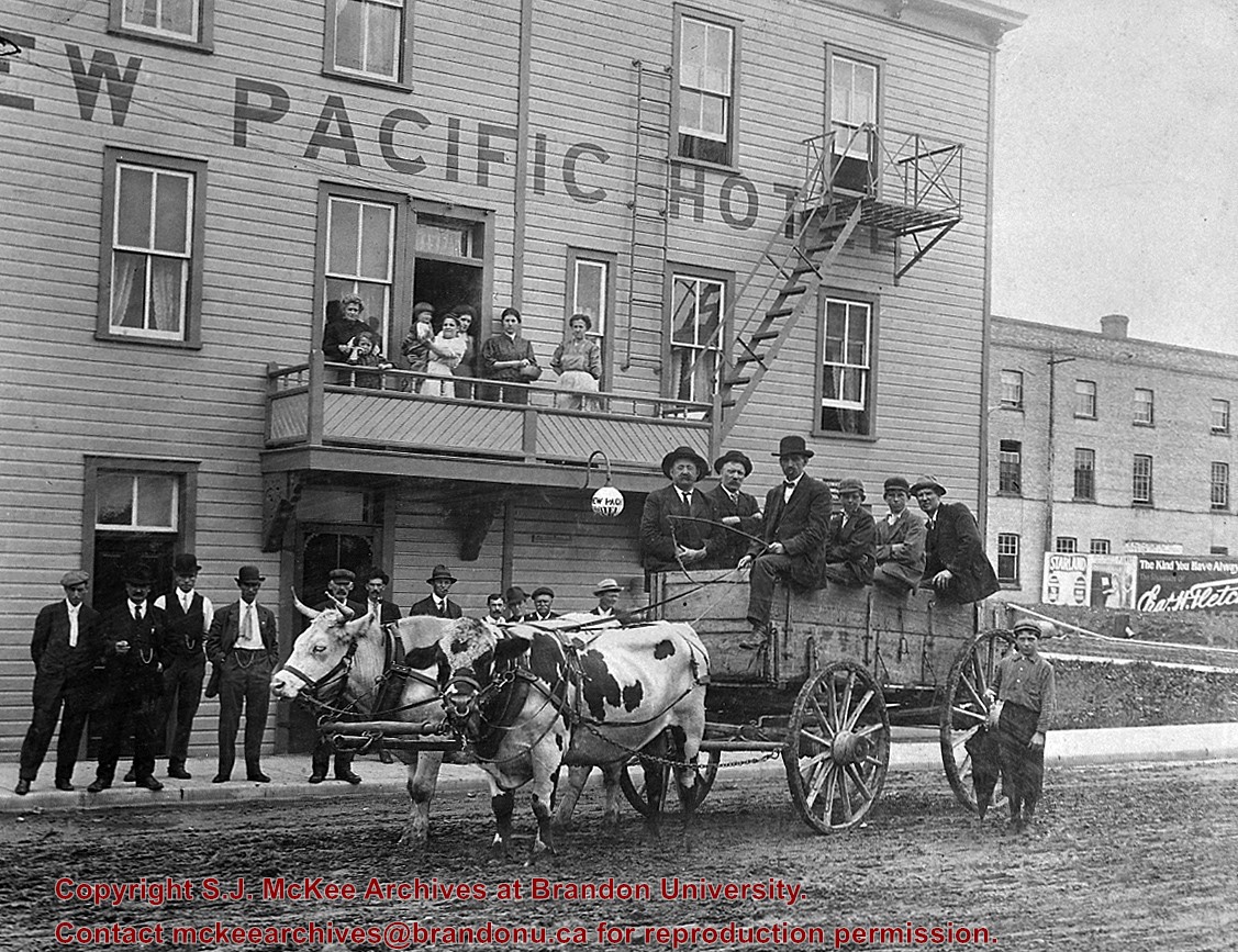
Photograph shows a panorama, bird's-eye-view of downtown Brandon, between Pacific and Rosser Avenues and 7th Street facing east. Photoraph likely taken from the McKenzie Seeds Building. Visible businesses include: Western Canada Flour Mills, Hanbury Hardware Co. Ltd., Cockshutt Plow Co., New Pacific Hotel, Gordon McKay Building, and Arlington Hotel.
Notes
Part of "Souvenir of Brandon, Manitoba, Canada [viewbook], Printed by Photogelatine Engraving Co. Limited, Ottawa." Dates obtained from the Burchill's Music Store Henderson's Brandon City Directory listings (1927-1929). Writing on the front of the photograph reads: Panorama of Brandon, Man.
Photographs have been glued to a backing board that has warped over time
Scope and Content
Photograph shows parade floats travelling on 100 block of 8th Street (Brandon). Horse-drawn floats appear to belong to the Amalgamated Society of Carpenters and Joiners, Murdock/Murdoch Brothers (furniture dealers), and F.W. Durst (cement contractor). Businesses visible in the background include the Sylvester Brothers Manufacturing Company and McDiarmid and Clarke lumber and fuel yard. Spectators in the foreground are leaning on a wooden fence likely belonging to the Old City Hall.
Notes
Writing on the front of the photograph matting reads: 315 July 1906. Two photographs (20-2009.7, 20-2009.6) are glued on the reverse side. Page appears to be from a photo album.
Brient was a point along the Algoma Central Railway line that connected the Helen Mine to the Michipicoten Harbour. It is located southwest of Wawa, Ontario.
Scope and Content
Photograph shows several men standing on railway tracks before a wood-framed train station in the winter. A sign attached to the station reads: British American Express Co. The man in the foreground appears to have a mailbag over on his back and several newspapers tucked beneath his arm.
Notes
Writing beneath the photograph in the album reads: station at Brient


