Show All Information
Album - Algoma Central and Hudson Bay Line
Part Of
Fred McGuinness collection
Description Level
Item
Series Number
McG 9
Item Number
1-2015.277.A14
Accession Number
1-2015
GMD
graphic
Date Range
[1900s]
Physical Description
4" x 2.5" (b/w)
Material Details
mounted in album
Physical Condition
Photo is warped
History / Biographical
In 1901, American entrepreneur Francis Hector Clergue (1856-1939) obtained the charter for the Ontario, Hudson Bay and Western Railway. Following his purchase, he reincoporated the Algoma Central Railway to the Algoma Central and Hudson's Bay Railway. (Source: Sault St. Mairie Public Library, "Transportation - Algoma Central Railway," Sault History Online, 2008)
Scope and Content
Photograph shows railroad tracks cutting through the Canadian Shield.
Notes
Writing beneath the photograph in the album reads: Algoma Central & Hundson Bay Ry.
Name Access
Algoma Central Railway Co.
Subject Access
Railroad Transportation railways mines railroads
Storage Location
1-2015 McG 1.4 Box 1 (in stacks, top shelf)
Show Less
Show All Information
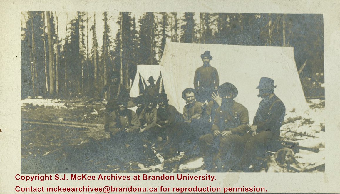
Album - Hawthorn? line in midwinter
Part Of
Fred McGuinness collection
Description Level
Item
Series Number
McG 9
Item Number
1-2015.277.A1
Accession Number
1-2015
GMD
graphic
Date Range
[1900s]
Physical Description
4" x 2.25" (b/w)
Material Details
mounted in album
Scope and Content
Photograph shows a group of 10 men seated on logs in front of two canvas tents in the bush.
Notes
Writing beneath the photograph in the album reads: Hawthorn? Line in midwinter
Subject Access
mines
Storage Location
1-2015 McG 1.4 Box 1 (in stacks, top shelf)
Arrangement
Funny trunk
Show Less
Show All Information
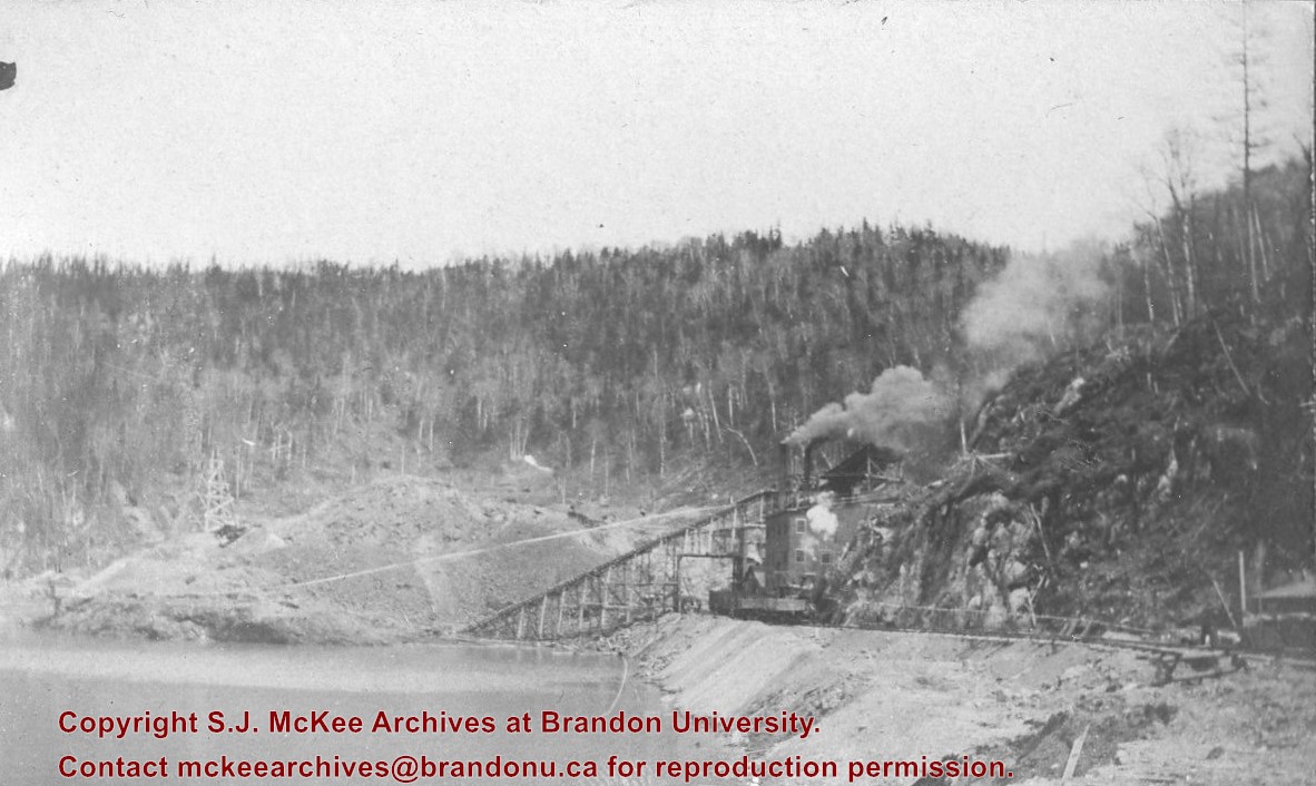
Album - Helen Mine
Part Of
Fred McGuinness collection
Description Level
Item
Series Number
McG 9
Item Number
1-2015.277.A19
Accession Number
1-2015
GMD
graphic
Date Range
[1900-1918]
Physical Description
4" x 2.5" (b/w)
Material Details
mounted in album
Physical Condition
Photo is warped
Scope and Content
Photograph shows a mine and tailing pond in the Canadian Shield.
Notes
Writing beneath the photograph in the album reads: Helen Mine
Name Access
Wawa, Ontario
Subject Access
mines
Storage Location
1-2015 McG 1.4 Box 1 (in stacks, top shelf)
Show Less
Show All Information
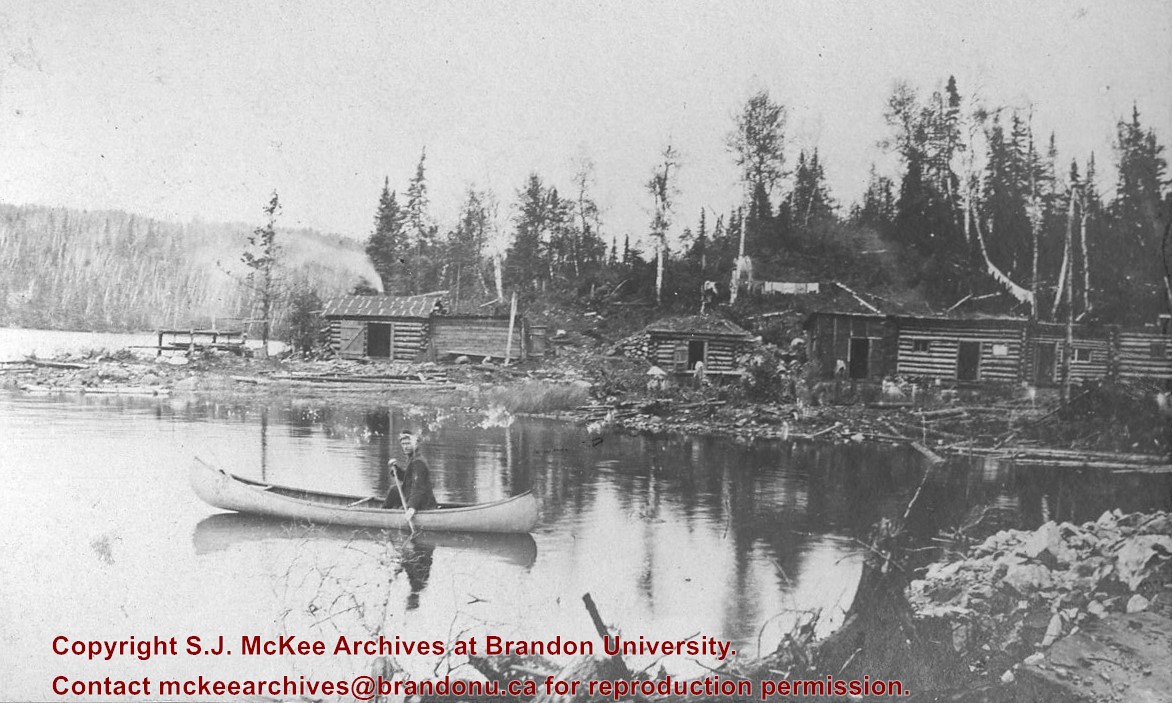
Album - Josephine Mine
Part Of
Fred McGuinness collection
Description Level
Item
Series Number
McG 9
Item Number
1-2015.277.A24
Accession Number
1-2015
GMD
graphic
Date Range
[1900s]
Physical Description
4" x 2.5" (b/w)
Material Details
mounted in album
Physical Condition
Photo is warped
Scope and Content
Photograph shows log cabins lining a lake shore. A man canoes on the water in the foreground.
Notes
Writing beneath the photograph in the album reads: Josephine Mine Camps
Subject Access
mines work camps canoes
Storage Location
1-2015 McG 1.4 Box 1 (in stacks, top shelf)
Show Less
Show All Information
Album - Lake Talbot Trestle
Part Of
Fred McGuinness collection
Description Level
Item
Series Number
McG 9
Item Number
1-2015.277.A15
Accession Number
1-2015
GMD
graphic
Date Range
[1900s]
Physical Description
4" x 2.5" (b/w)
Material Details
mounted in album
Physical Condition
Photo is warped
History / Biographical
The Lake Talbot tresle was a point along the Algoma Central Railway line that connected the Helen Mine to the Michipicoten Harbour. It is located north of Wawa and southwest of the Helen Mine.
Scope and Content
Photograph shows several men walking a railway line. Before them is a tresle bridge.
Notes
Writing beneath the photograph in the album reads: Lake Talbott Tresle [sic.]
Subject Access
Railroad Transportation railways mines railroads
Storage Location
1-2015 McG 1.4 Box 1 (in stacks, top shelf)
Show Less
Show All Information
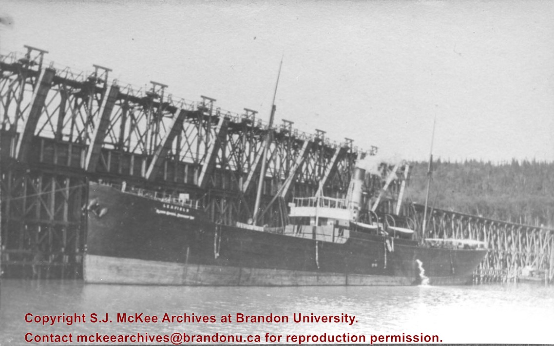
Album - Ore dock and vessel
Part Of
Fred McGuinness collection
Description Level
Item
Series Number
McG 9
Item Number
1-2015.277.A6
Accession Number
1-2015
GMD
graphic
Date Range
[1900s]
Physical Description
4" x 2.5" (b/w)
Material Details
mounted in album
Physical Condition
Photo is warped
Scope and Content
Photograph shows the steam ship "Leafield" at the ore dock, possibly at Michipicoten harbor.
Notes
Writing beneath the photograph in the album reads: Ore dock and vessel
Name Access
Michipicoten harbour
Subject Access
mines
Storage Location
1-2015 McG 1.4 Box 1 (in stacks, top shelf)
Show Less
Show All Information
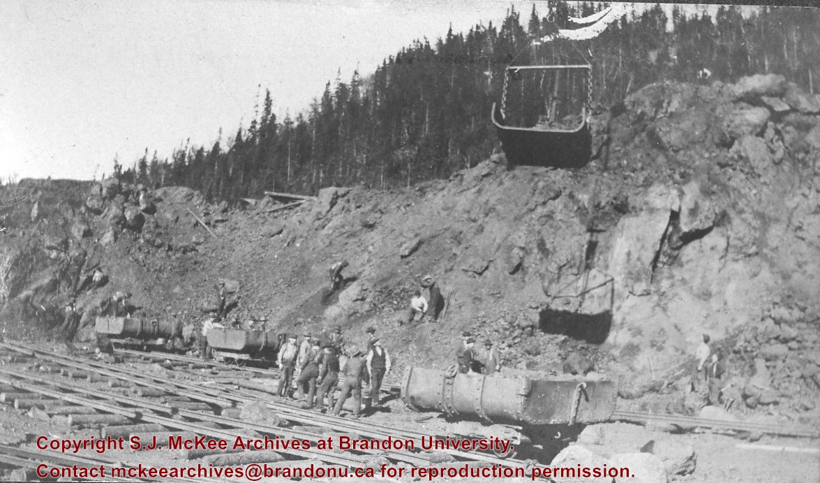
Album - "the pit"
Part Of
Fred McGuinness collection
Description Level
Item
Series Number
McG 9
Item Number
1-2015.277.A22
Accession Number
1-2015
GMD
graphic
Date Range
[1900s]
Physical Description
4" x 2.5" (b/w)
Material Details
mounted in album
Physical Condition
Photo is warped
Scope and Content
Photograph shows a pit mine in the Canadian Shield. Ore cars are placed on temporary tracks resting on logs.
Notes
Writing beneath the photograph in the album reads: "The Pit"
Subject Access
mines
Storage Location
1-2015 McG 1.4 Box 1 (in stacks, top shelf)
Show Less
Show All Information
Album - Trembley iron ore cars
Part Of
Fred McGuinness collection
Description Level
Item
Series Number
McG 9
Item Number
1-2015.277.A13
Accession Number
1-2015
GMD
graphic
Date Range
[1900s]
Physical Description
4" x 2.5" (b/w)
Material Details
mounted in album
Physical Condition
Photo is warped
History / Biographical
Trembley was a point along the Algoma Central Railway line that connected the Helen Mine to the Michipicoten Harbour. It is located southwest of Wawa, Ontario.
Scope and Content
Photograph shows railroad tracks. A line of ore cars stretch along one track. Writing on the side of one of the cars (#3017) reads: Algoma Central Railway Co.
Notes
Writing beneath the photograph in the album reads: Trembley - Ore Cars
Name Access
Algoma Central Railway Co.
Subject Access
Railroad Transportation railways mines
Storage Location
1-2015 McG 1.4 Box 1 (in stacks, top shelf)
Show Less
Show All Information
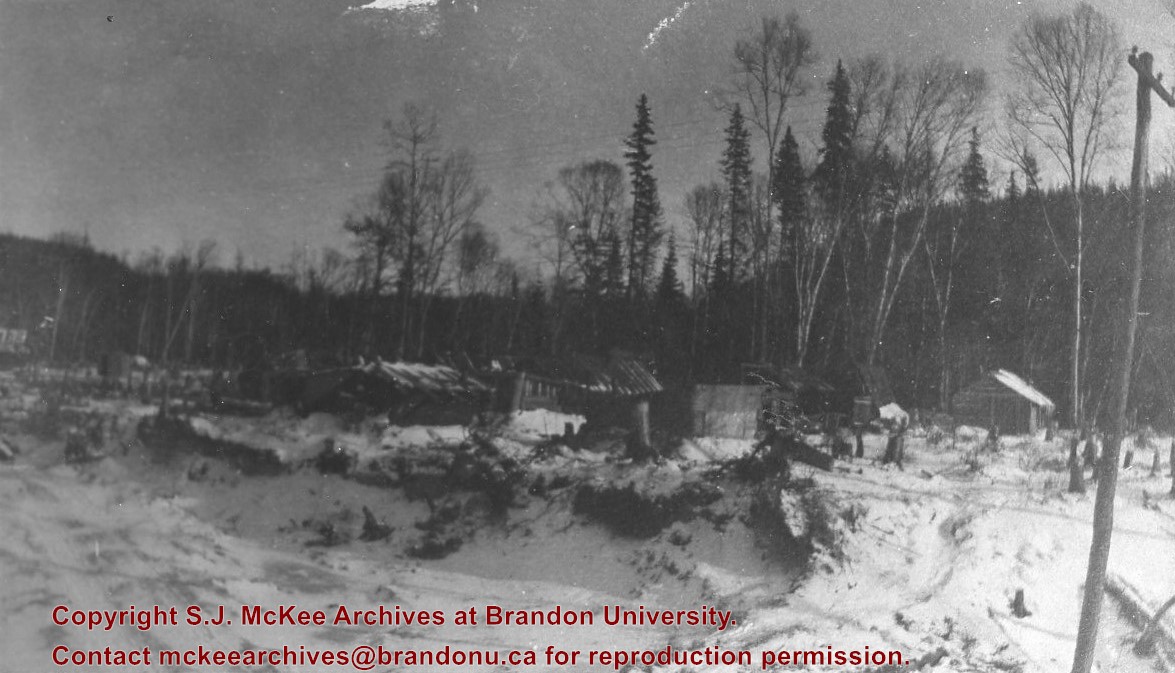
Album - work camp
Part Of
Fred McGuinness collection
Description Level
Item
Series Number
McG 9
Item Number
1-2015.277.A10
Accession Number
1-2015
GMD
graphic
Date Range
[1900s]
Physical Description
4" x 2.5" (b/w)
Material Details
mounted in album
Physical Condition
Photo is warped
Scope and Content
Photograph shows a possible work camp in the brush during the winter. Possibly occupied by Italian workmen.
Notes
Writing beneath the photograph in the album reads: "Dago" Colony
Subject Access
winter work camps
Storage Location
1-2015 McG 1.4 Box 1 (in stacks, top shelf)
Show Less
Show All Information
Album - yard at Brient
Part Of
Fred McGuinness collection
Description Level
Item
Series Number
McG 9
Item Number
1-2015.277.A8
Accession Number
1-2015
GMD
graphic
Date Range
[1900s]
Physical Description
4" x 2.5" (b/w)
Material Details
mounted in album
Physical Condition
Photo is warped
History / Biographical
Brient was a point along the Algoma Central Railway line that connected the Helen Mine to the Michipicoten Harbour. It is located southwest of Wawa, Ontario.
Scope and Content
Photograph shows ore box cars in a railway yard.
Notes
Writing beneath the photograph in the album reads: yard at Brient
Name Access
Brient, Ontario
Subject Access
mines railways Transportation winter
Storage Location
1-2015 McG 1.4 Box 1 (in stacks, top shelf)
Show Less
Show All Information
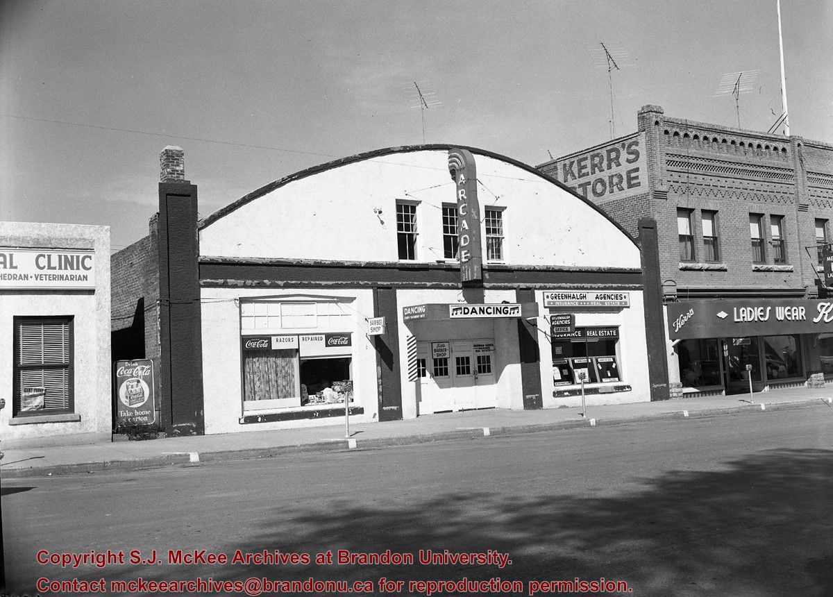
Arcade dance (Neepawa)
Part Of
CKX fonds
Description Level
Item
GMD
graphic
Date Range
after 1954
Accession Number
11-2010
Show All Information
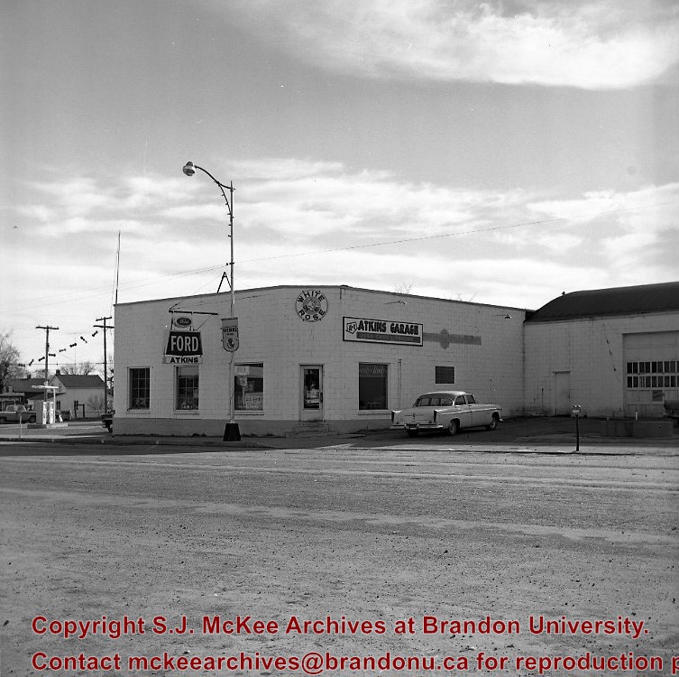
Atkins Motors (Neepawa)
Part Of
CKX fonds
Description Level
Item
GMD
graphic
Date Range
after 1954
Accession Number
11-2010
Show All Information
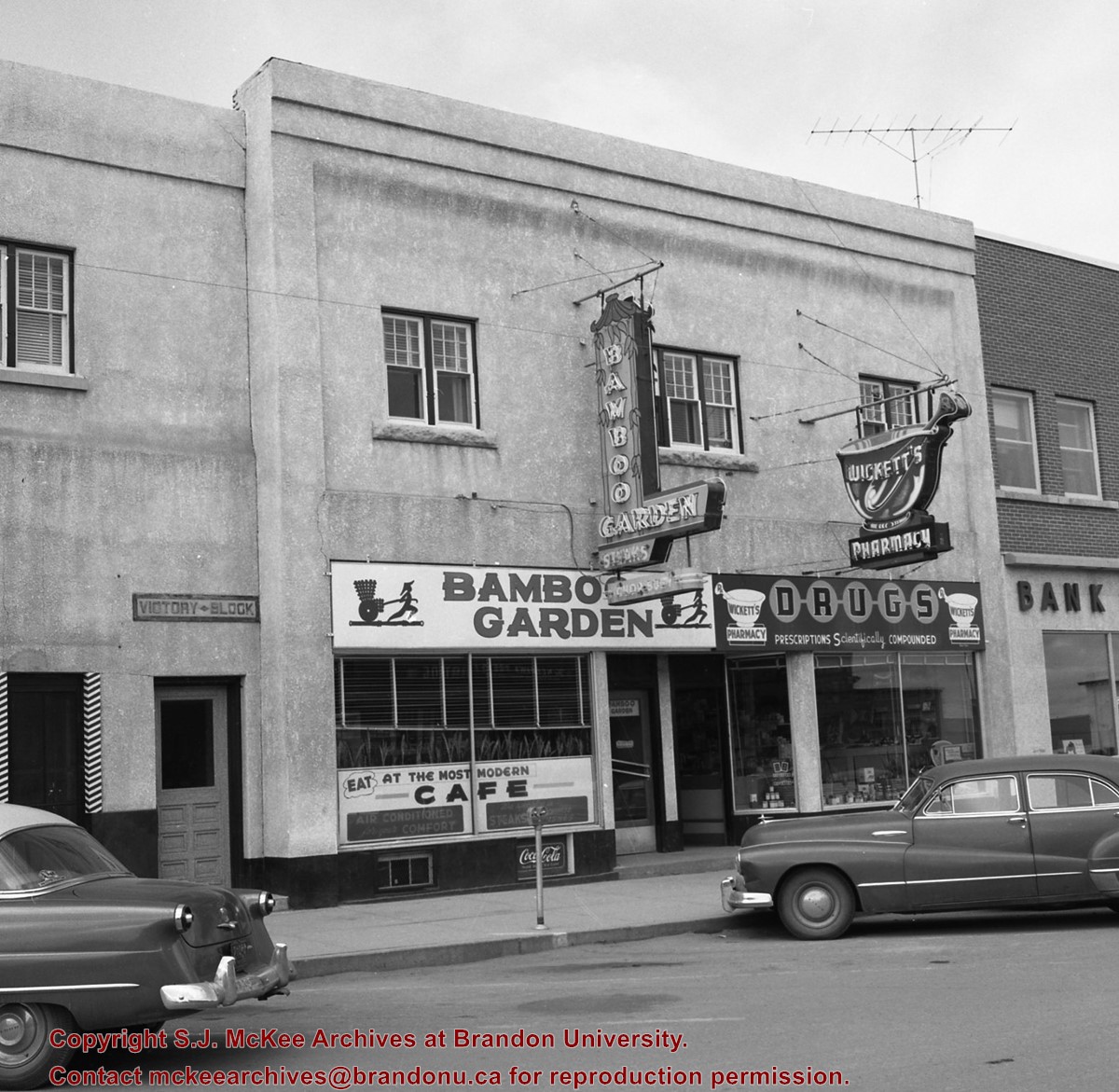
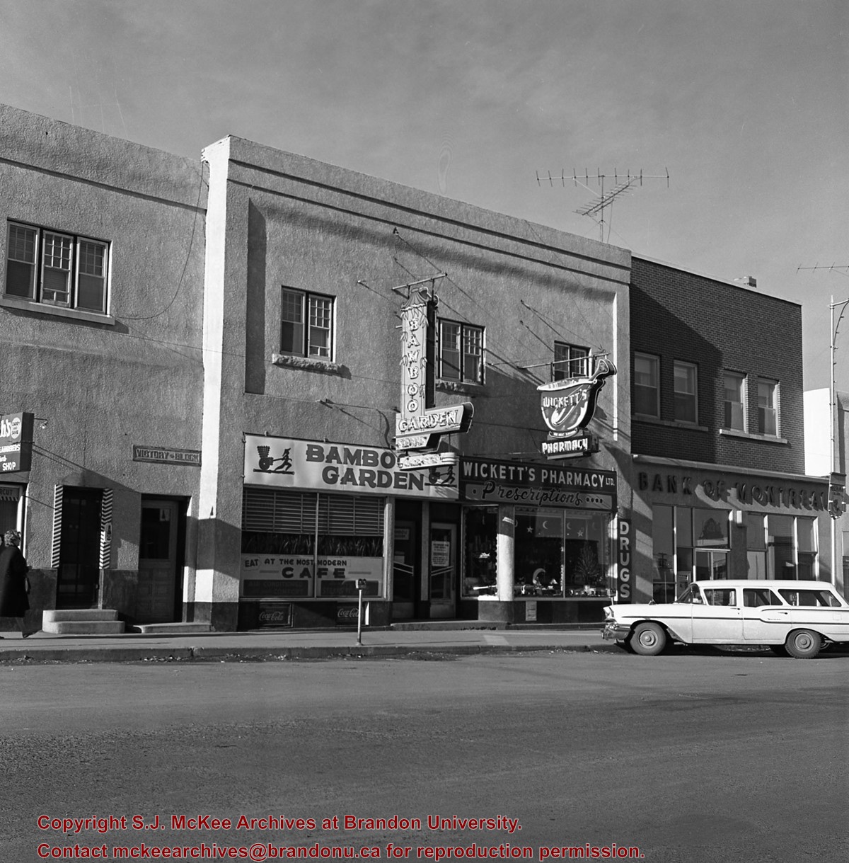
Bamboo Garden (Neepawa) - exterior
Part Of
CKX fonds
Description Level
Item
GMD
graphic
Date Range
after 1954
Accession Number
11-2010
Part Of
CKX fonds
Creator
CKX
Description Level
Item
Item Number
11-2010.B10a
Accession Number
11-2010
GMD
graphic
Date Range
after 1954
Physical Description
2.25" x 2.25" (b/w)
Material Details
Negative
Custodial History
See fonds level of the CKX records for custodial history.
Scope and Content
Image shows the exterior of the Bamboo Garden restaurant in Neepawa.
Name Access
CKX Bamboo Garden Neepawa, Manitoba Wickett's Pharmacy Victory Block
Subject Access
restaurants
Storage Location
CKX fonds - 2010 accessions
Show Less
Show All Information
Bamboo Garden (Neepawa) - exterior
Part Of
CKX fonds
Description Level
Item
GMD
graphic
Date Range
after 1954
Accession Number
11-2010
Show All Information
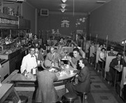
Bamboo Garden (Neepawa) - interior
Part Of
CKX fonds
Description Level
Item
GMD
graphic
Date Range
after 1954
Accession Number
11-2010
Part Of
CKX fonds
Creator
CKX
Description Level
Item
Item Number
11-2010.B10b
Accession Number
11-2010
GMD
graphic
Date Range
after 1954
Physical Description
5" x 4" (b/w)
Material Details
Negative
Custodial History
See fonds level of the CKX records for custodial history.
Scope and Content
Images shows the interior of the Bamboo Garden restaurant in Neepawa.
Name Access
CKX Bamboo Garden Neepawa, Manitoba
Subject Access
restaurants
Storage Location
CKX fonds - 2010 accessions
Show Less
Show All Information
Bamboo Garden (Neepawa) - interior
Part Of
CKX fonds
Description Level
Item
GMD
graphic
Date Range
after 1954
Accession Number
11-2010
Part Of
CKX fonds
Creator
CKX
Description Level
Item
Item Number
11-2010.B10c
Accession Number
11-2010
GMD
graphic
Date Range
after 1954
Physical Description
5" x 4" (b/w)
Material Details
Negative
Custodial History
See fonds level of the CKX records for custodial history.
Scope and Content
Image shows the interior of the Bamboo Garden restaurant in Neepawa.
Name Access
CKX Bamboo Garden Neepawa, Manitoba
Subject Access
restaurants
Storage Location
CKX fonds - 2010 accessions
Show Less
Show All Information
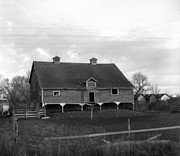
Barn with open front cow shelter, east of Neepawa PTH 16, Manitoba
Part Of
RG 11 Lawrence Stuckey fonds
Creator
L.A. Stuckey
Description Level
Item
Series Number
3.3
Item Number
1-2002.3.3.BNE[299]
Accession Number
1-2002
GMD
graphic
Date Range
October 30,1979
Physical Description
2.25" x 2.25" (b/w)
Material Details
Negative
Custodial History
For custodial history see the collection level description of the Lawrence Stuckey collection.
Scope and Content
Image of barn with open front cow shelter, east of Neepawa PTH 16, Manitoba.
Notes
[Brandon NE includes communities north of Trans-Canada #1 highway and east of PTH #10.]
Name Access
Neepawa, Manitoba
Subject Access
barns agricultural buildings
Repro Restriction
The McKee Archives is the copyright holder of the Stuckey materials.
Storage Location
Lawrence Stuckey collection
Show Less
Show All Information
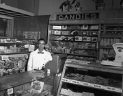
Bell Lumber (Neepawa)
Part Of
CKX fonds
Description Level
Item
GMD
graphic
Date Range
after 1954
Accession Number
11-2010
Part Of
CKX fonds
Creator
CKX
Description Level
Item
Item Number
11-2010.B28
Accession Number
11-2010
GMD
graphic
Date Range
after 1954
Physical Description
2.5" x 2.5" (b/w)
Material Details
Negative
Custodial History
See fonds level of the CKX records for custodial history.
Scope and Content
Image of the exterior of Bell Lumber (Neepawa).
Name Access
CKX Neepawa, Manitoba
Subject Access
Buildings commercial buildings
Storage Location
CKX fonds - 2010 accessions
Show Less
Show All Information
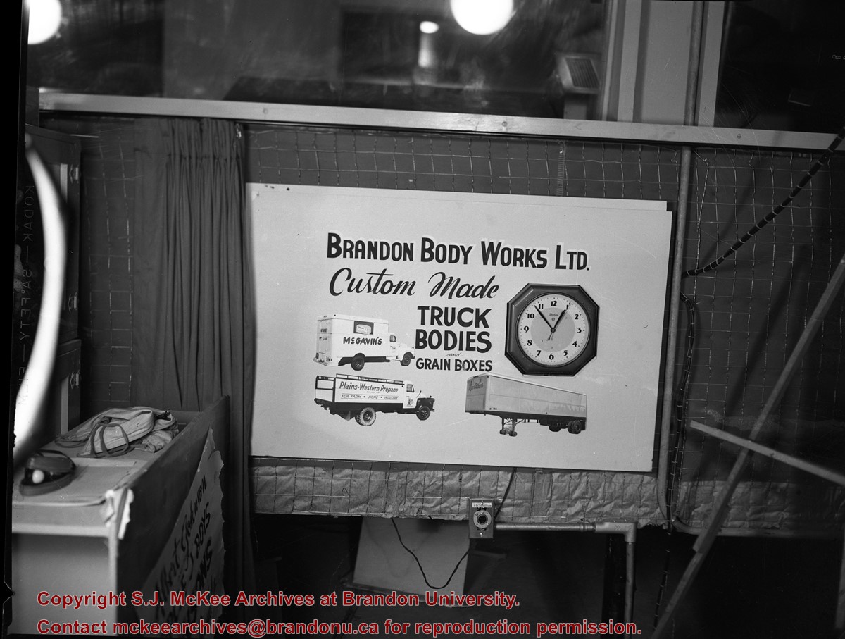
Brandon Body Works Ltd.
Part Of
CKX fonds
Description Level
Item
GMD
graphic
Date Range
after 1954
Accession Number
11-2010
Show All Information
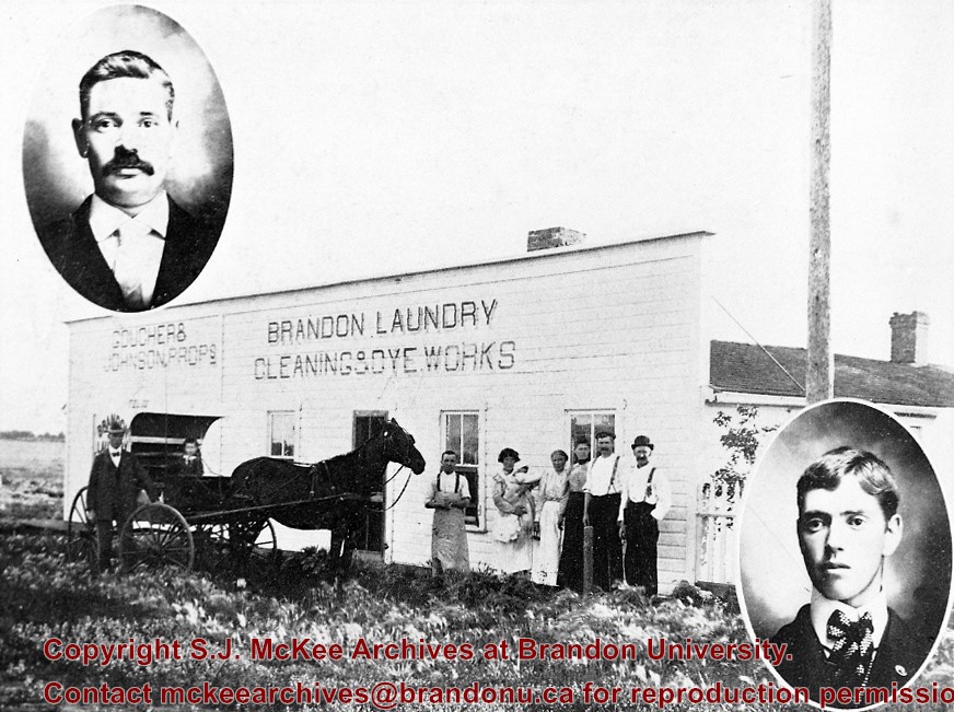
Brandon Laundry, Cleaning & Dye Works
Part Of
RG 11 Lawrence Stuckey fonds
Description Level
Item
Series Number
3.1
Item Number
1-2002.3.1E29
Accession Number
1-2002
GMD
graphic
Date Range
[18-?]
Physical Description
3 1/2" x 5"
Material Details
Negative
Custodial History
For custodial history see the collection level description of the Lawrence Stuckey collection.
Scope and Content
Brandon Laundry, Cleaning & Dye Works
[Goucher & Johnson Proprietors]
Notes
[This negative appears to have been produced using a pre-existing published image (P.E. 22/06/09).]
Name Access
Brandon Laundry, Cleaning & Dye Works
Subject Access
businesses laundries Brandon business buildings & facilities before 1940
Repro Restriction
The McKee Archives is the copyright holder for the Stuckey materials.
Storage Location
Lawrence Stuckey collection
Show Less


)
)
+-+exterior)
+-+exterior)
+-+interior)
+-+interior)
)