Show All Information
Brandon Municipal Railway Map
Part Of
RG 11 Lawrence Stuckey fonds
Description Level
Item
Series Number
3.1
Item Number
1-2002.3.1I1
Accession Number
1-2002
GMD
graphic
Date Range
[19-]
Physical Description
3 1/2" x 5"
Material Details
Negative
Custodial History
For custodial history see the collection level description of the Lawrence Stuckey collection.
Scope and Content
Brandon Municipal Railway Map
Notes
From Canadian Railroad Historical Association
Name Access
Brandon Municipal Railway
Subject Access
public transit maps streetcars Brandon Street Railway
Repro Restriction
The McKee Archives is the copyright holder for the Stuckey materials.
Storage Location
Lawrence Stuckey collection
Show Less
Show All Information
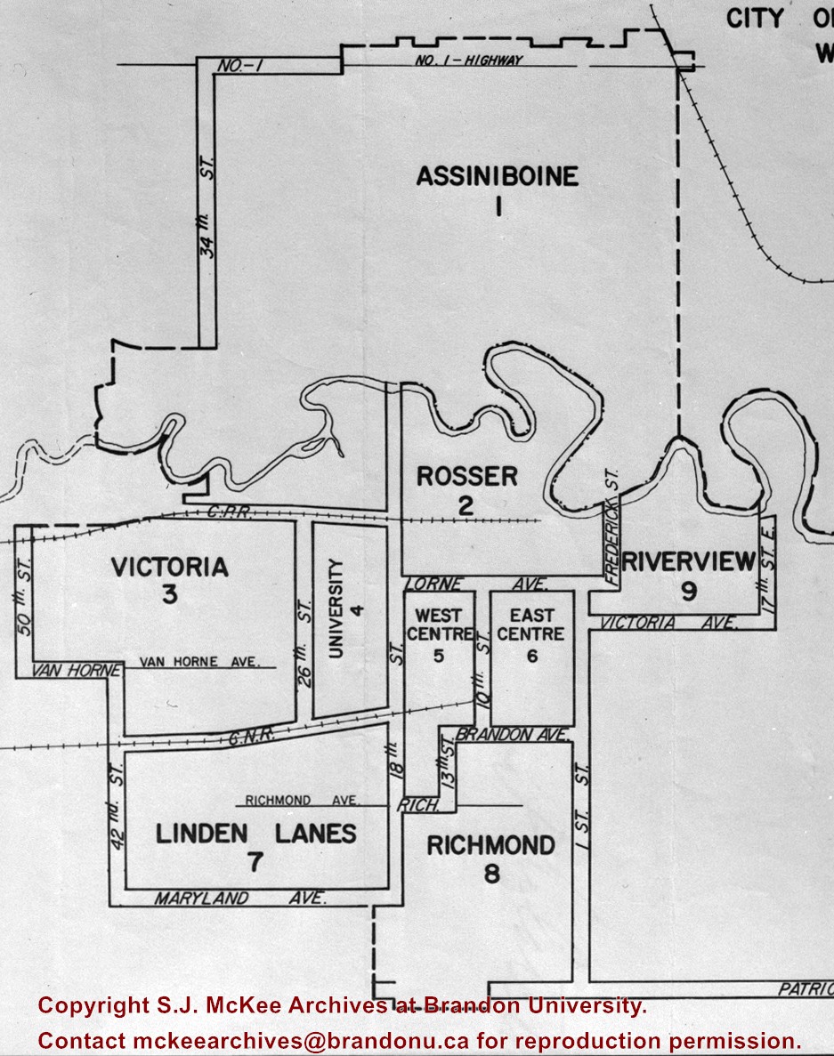
Brandon Ward Map
Part Of
RG 11 Lawrence Stuckey fonds
Description Level
Item
Series Number
3.1
Item Number
1-2002.3.1NA6
Accession Number
1-2002
GMD
graphic
Date Range
1971
Physical Description
3 1/2" x 5"
Material Details
Negative
History / Biographical
The City of Brandon (by decree of the Province) went to a ward system of government with the civic elections of October of 1971. Ten aldermen, who had to reside in their wards, were elected by the people of their wards. The Mayor was elected by the city at large. The previous committee system was abolished and individual aldermen henceforth had no specific responsibilities.
Custodial History
For custodial history see the collection level description of the Lawrence Stuckey collection.
Scope and Content
Brandon Ward Map
Name Access
Brandon Ward Map
Subject Access
politics political geographic features cities districts Brandon Miscellaneous History
Repro Restriction
The McKee Archives is the copyright holder for the Stuckey materials.
Storage Location
Lawrence Stuckey collection
Show Less
Show All Information
The map-maker : the story of David Thompson
Show All Information
Gage's new primer of map geography
Part Of
MG 2 2.15 George E Thorman Collection
Collection
George E Thorman School Textbook Collection
Creator
Gage, W. J., & Company
Description Level
Item
Item Number
Archives 11-999-12-333
Item Number Range
Archives 11-999-12-333
Start Date
1892
Date Range
1892
Publication
Toronto : W. J. Gage & Company
Physical Description
68, 16 p. : maps (part double) ; 21 cm
Subject Access
Geography Textbooks
Storage Location
Box 12 - Geography
Storage Range
Box 12 - Geography
Show Less
Show All Information
Princess Avenue, Including City Hall & Radio Tower
Part Of
RG 11 Lawrence Stuckey fonds
Creator
C.J. Smith
Description Level
Item
Series Number
3.1
Item Number
1-2002.3.1C11
Accession Number
1-2002
GMD
graphic
Date Range
[between 1928 and 1930]
Physical Description
3 1/2" x 5"
Material Details
Negative
History / Biographical
[The land on which city hall stood in this photo is now known as Princess Park. P.E. 01/06/09]
Custodial History
For custodial history see the collection level description of the Lawrence Stuckey collection.
Scope and Content
Princess Avenue, showing City Hall & CKX radio tower
Notes
[View is from 9th Street looking east. P.E.]
"Radio towers of CKX on city hall grounds were 150 feet tall; Studio and transmitter were on the east side of city hall." - Fred McGuinness collection (20-2009).
Name Access
Princess Avenue, Including City Hall & Radio Tower
Subject Access
downtowns city halls businesses Brandon Street Scenes Before 1940
Repro Restriction
The McKee Archives is the copyright holder for the Stuckey materials.
Storage Location
Lawrence Stuckey collection
Show Less
Show All Information
High school geography : with maps and illustrations
Part Of
MG 2 2.15 George E Thorman Collection
Collection
George E Thorman School Textbook Collection
Creator
Chase, G. A
Description Level
Item
Item Number
Archives 11-999-10-295
Item Number Range
Archives 11-999-10-295
Responsibility
by G. A. Chase
Start Date
c1887
Date Range
c1887
Publication
Toronto : Can. Pub. Co
Physical Description
viii, 198 p. : ill., map ; 24 cm
Notes
Part 1. Physical -- Part 2. Descriptive
Subject Access
geography
Storage Location
Box 10 - Geography
Storage Range
Box 10 - Geography
Show Less
Show All Information
Lovell's general geography : with maps and illustrations
Part Of
MG 2 2.15 George E Thorman Collection
Collection
George E Thorman School Textbook Collection
Creator
Hodgins, J. George (John George), 1821-1912
Description Level
Item
Item Number
Archives 11-999-12-337
Item Number Range
Archives 11-999-12-337
Start Date
[1861]
Date Range
[1861]
Publication
Montreal : Lovell
Publisher Series
Lovell's series of school books
Physical Description
100 p. : ill., maps ; 29 cm
Subject Access
geography
Storage Location
Box 12 - Geography
Storage Range
Box 12 - Geography
Show Less
Show All Information
Outlines of history : illustrated by numerous geographical and historical notes and maps
Part Of
MG 2 2.15 George E Thorman Collection
Collection
George E Thorman School Textbook Collection
Creator
Willson, Marcius, 1813-1905
Description Level
Item
Item Number
Archives 11-999-17-448
Item Number Range
Archives 11-999-17-448
Responsibility
by Marcius Willson
Start Date
1876
Date Range
1876
Publication
New York : Ivison, Blakeman, Taylor & Co
Physical Description
2 v. in 1 (600 p.) : ill., col. maps ; 21 cm
Notes
Includes bibliogaphical references and index
pt. 1. Ancient history -- pt. 2. Modern history
Subject Access
World history Outlines
Storage Location
Box 17 - History
Storage Range
Box 17 - History
Show Less
Show All Information
A grammar of general geography for the use of schools and young persons : with maps & engravings
Part Of
MG 2 2.15 George E Thorman Collection
Collection
George E Thorman School Textbook Collection
Creator
Goldsmith, J
Description Level
Item
Item Number
Archives 11-999-11-307
Item Number Range
Archives 11-999-11-307
Responsibility
by J. Goldsmith
Start Date
[1824]
Date Range
[1824]
Publication
London : Longman, Rees, Orme, Brown and Green
Physical Description
192 p. : ill., maps ; 14 cm
Notes
"A new edition corrected and modernized"
Subject Access
geography G©ographie
Storage Location
Box 11 - Geography
Storage Range
Box 11 - Geography
Show Less
Show All Information
Lovell's intermediate geography : with maps and illustrations, being introductory to Lovell's advanced geography
Part Of
MG 2 2.15 George E Thorman Collection
Collection
George E Thorman School Textbook Collection
Description Level
Item
Item Number
Archives 11-999-12-339
Item Number Range
Archives 11-999-12-339
Start Date
1879
Date Range
1879
Publication
Montreal : J. Lovell
Physical Description
104 p. : ill. ; 22 cm
Subject Access
geography
Storage Location
Box 12 - Geography
Storage Range
Box 12 - Geography
Show Less
Show All Information
Easy lessons in general geography : with maps and illustrations ; being introductory to "lovell's general geography"
Show All Information
Geography generalized ; or, An introduction to the study of geography on the principles of classification and comparison : with maps and illustrations and an introduction to astronomy
Part Of
MG 2 2.15 George E Thorman Collection
Collection
George E Thorman School Textbook Collection
Creator
Sullivan, Robert, 1800?-1868
Description Level
Item
Item Number
Archives 11-999-11-324
Item Number Range
Archives 11-999-11-324
Responsibility
by Robert Sullivan
Start Date
1857
Date Range
1857
Publication
Dublin : Marcus and John Sullivan ; London : Longmans, Green and Co
Physical Description
384 p. : ill., maps ; 17 cm
Subject Access
geography
Storage Location
Box 11 - Geography
Storage Range
Box 11 - Geography
Show Less
Show All Information
A primer of map geography : for pupils preparing for promotion examinations; pupils preparing for entrance examinations; pupils preparing for intermediate examinations; students preparing for teacher's certificates, and all offical examinations with recent departmental examination papers from the provinces of Ontario, Manitoba, and Nova Scotia


