Skip header and navigation

Revise Search

77 records – page 1 of 4.

Aerial view: Brandon College

http://archives.brandonu.ca/en/permalink/descriptions594
Part Of
Brandon University Photograph collection
Description Level
Item
GMD
graphic
Date Range
[fall 1964?]
Part Of
Brandon University Photograph collection
Description Level
Item
Series Number
2.1
Item Number
BUPC 2.1.2
GMD
graphic
Date Range
[fall 1964?]
Physical Description
5" x 4" (b/w)
Scope and Content
Brandon College looking south from 19th Street. Photograph was taken after Flora Cowan Hall was built but before construction of the Education Building.
Subject Access
aerial photographs
campus photographs
campus buildings
Brandon streets
Images
Show Less

Aerial view: Brandon College from 23rd Street

http://archives.brandonu.ca/en/permalink/descriptions602
Part Of
Brandon University Photograph collection
Description Level
Item
GMD
graphic
Date Range
[1963-1966]
Part Of
Brandon University Photograph collection
Description Level
Item
Series Number
2.1
Item Number
BUPC 2.1.9
GMD
graphic
Date Range
[1963-1966]
Physical Description
5" x 4" (b/w)
Scope and Content
Image is looking east northeast from approximately the 300 block of 23rd Street between Lorne and Louise Avenues. Photograph shows the Brandon College campus after the opening of the original Music Building in 1963, but before the construction of the Education Building in 1966. A number of house on the 300 blocks of 22nd and 21st Streets are visible in the foreground, with the A.E. McKenzie Seed Co., the Prince Edward Hotel and various grain elevators on the horizon.
Subject Access
aerial photographs
campus photographs
campus buildings
Brandon streets
Grain elevators
Images
Show Less

Aerial view - Brandon College looking southwest

http://archives.brandonu.ca/en/permalink/descriptions601
Part Of
Brandon University Photograph collection
Description Level
Item
GMD
graphic
Date Range
[1963-1966]
Part Of
Brandon University Photograph collection
Description Level
Item
Series Number
2.1
Item Number
BUPC 2.1.8
GMD
graphic
Date Range
[1963-1966]
Physical Description
5" x 4" (b/w)
Scope and Content
Image shows the Brandon College campus from 17th Street looking southwest. The photo was taken after the completion of the original Music Building in 1963, but construction of the Education Building. Also visible are a number of properties on the 200 block of 18th Street and the 200 block of 20th Street.
Subject Access
aerial photographs
campus photographs
campus buildings
Brandon streets
Images
Show Less

Aerial view - Brandon University campus

http://archives.brandonu.ca/en/permalink/descriptions7989
Part Of
Brandon University Photograph collection
Description Level
Item
GMD
graphic
Date Range
c. 2000
Part Of
Brandon University Photograph collection
Creator
Photograph commissioned by Brandon University and taken by Yourview Aerial Scenics Ltd.
Description Level
Item
Series Number
2.1
Item Number
BUPC 2.1.55
GMD
graphic
Date Range
c. 2000
Physical Description
6" x 4" (colour)
Scope and Content
View is southwest from approximatley 16th Street between Princess and Rosser Avenues. Photograph shows the Brandon University campus, as well as surrounding residential blocks, including Flemming, J.R. Reid and Vincent Massey schools.
Subject Access
aerial photographs
campus photographs
campus buildings
Brandon streets
Images
Show Less

Aerial view - Brandon University campus

http://archives.brandonu.ca/en/permalink/descriptions7990
Part Of
Brandon University Photograph collection
Description Level
Item
GMD
graphic
Date Range
c. 2000
Part Of
Brandon University Photograph collection
Creator
Photograph commissioned by Brandon University and taken by Yourview Aerial Scenics Ltd.
Description Level
Item
Series Number
2.1
Item Number
BUPC 2.1.56
GMD
graphic
Date Range
c. 2000
Physical Description
6" x 4" (colour)
Scope and Content
View is west southwest from approximatley 16th Street between Princess and Lorne Avenues. Photograph shows the Brandon University campus, as well as surrounding residential blocks between 16th and 23rd Streets, Princess and Louise Avenues..
Subject Access
aerial photographs
campus photographs
campus buildings
Brandon streets
Images
Show Less

Aerial view - Brandon University campus

http://archives.brandonu.ca/en/permalink/descriptions7991
Part Of
Brandon University Photograph collection
Description Level
Item
GMD
graphic
Date Range
c. 2000
Part Of
Brandon University Photograph collection
Creator
Photograph commissioned by Brandon University and taken by Yourview Aerial Scenics Ltd.
Description Level
Item
Series Number
2.1
Item Number
BUPC 2.1.57
GMD
graphic
Date Range
c. 2000
Physical Description
6" x 4" (colour)
Scope and Content
View is west from approximatley 17th Street between Lorne and Louise Avenues. Photograph shows a portion of the Brandon University campus (excluding the Education Building and anything north of it), as well as surrounding residential blocks from approximatley 17th Street to 22nd Street.
Subject Access
aerial photographs
campus photographs
campus buildings
Brandon streets
Images
Show Less

Aerial view - Brandon University campus

http://archives.brandonu.ca/en/permalink/descriptions7992
Part Of
Brandon University Photograph collection
Description Level
Item
GMD
graphic
Date Range
c. 1990
Part Of
Brandon University Photograph collection
Description Level
Item
Series Number
2.1
Item Number
BUPC 2.1.58
GMD
graphic
Date Range
c. 1990
Physical Description
5" x 3.5" (colour)
Scope and Content
View is west northwest from approximatley 16th Street and Louise Avenue. Photograph shows the Brandon University campus, prior to the Library Extension, and a large portion of the city to the west of the campus.
Subject Access
aerial photographs
campus photographs
campus buildings
Brandon streets
Images
Show Less

Aerial view - Brandon University campus

http://archives.brandonu.ca/en/permalink/descriptions7993
Part Of
Brandon University Photograph collection
Description Level
Item
GMD
graphic
Date Range
c. 1990
Part Of
Brandon University Photograph collection
Description Level
Item
Series Number
2.1
Item Number
BUPC 2.1.59
GMD
graphic
Date Range
c. 1990
Physical Description
5" x 3.5" (colour)
Scope and Content
View is northwest from approximatley 16th Street and Louise Avenue. Photograph shows the Brandon University campus, prior to the Library Extension, and a large portion of the city to the west of the campus.
Subject Access
aerial photographs
campus photographs
campus buildings
Brandon streets
Show Less

Aerial view: Brandon University campus

http://archives.brandonu.ca/en/permalink/descriptions8064
Part Of
Brandon University Photograph collection
Description Level
Item
GMD
graphic
Date Range
[1972-1978]
Part Of
Brandon University Photograph collection
Description Level
Item
Series Number
2.1
Item Number
BUPC 2.1.133
GMD
graphic
Date Range
[1972-1978]
Physical Description
10" x 8" (b/w)
Scope and Content
View is southwest from approximatley 16th Street between Lorne Avenue and Princess Avenue. The view extends to approximately 26th Street. Photograph shows the Brandon University campus, Kinsmen Stadium, Fleming School, Coronation Park and residential blocks.
Images
Show Less

Aerial view: Brandon University campus

http://archives.brandonu.ca/en/permalink/descriptions2576
Part Of
Brandon University Photograph Collection
Description Level
Item
GMD
graphic
Date Range
September 21, 1999
Part Of
Brandon University Photograph Collection
Description Level
Item
Series Number
9
Item Number
BUPC 9.36
GMD
graphic
Date Range
September 21, 1999
Physical Description
11" x 14" (colour)
History / Biographical
The photograph was taken for the Centennial of Brandon College/University.
Scope and Content
Aerial photograph taken looking southwest from approximately the northeast corner of Princess Avenue and 17th Street. The entire campus, as well as a number of residential streets are visible.
Notes
Negative is located with the photograph
Subject Access
campus buildings
aerial photographs
aerial photography
aerial views
cityscapes
Storage Range
Oversized drawer 4
Images
Show Less

Aerial view: Brandon University campus

http://archives.brandonu.ca/en/permalink/descriptions2577
Part Of
Brandon University Photograph Collection
Description Level
Item
GMD
graphic
Date Range
September 21, 1999
Part Of
Brandon University Photograph Collection
Creator
Photographer: Aberson Photo
Description Level
Item
Series Number
9
Item Number
BUPC 9.70
GMD
graphic
Date Range
September 21, 1999
Physical Description
16" x 20" (colour)
History / Biographical
The photograph may have been taken for Brandon University's centennial.
Scope and Content
Photograph is looking northeast from approximately Victoria Avenue and 21st Street and shows the Brandon University campus, Kinsmen Stadium, the Assiniboine River and a number of residential neighbourhoods.
Storage Range
Oversize drawer 6
Show Less
Part Of
Brandon University Photograph Collection
Description Level
Item
GMD
graphic
Date Range
1938
Part Of
Brandon University Photograph Collection
Creator
Photographer: Jerrett's
Description Level
Item
Series Number
8
Item Number
8.B.17
GMD
graphic
Date Range
1938
Physical Description
2.5" x 3.5" (b/w)
Custodial History
Photograph donated by Marion Stone '40.
Scope and Content
Portrait of student Betty Brown. View is east from the front lawn where Brown is standing. Houses on the east side of 18th Street are visible.
Show Less

Brandon College Building

http://archives.brandonu.ca/en/permalink/descriptions823
Part Of
Brandon University Photograph Collection
Description Level
Item
GMD
graphic
Date Range
1982
Part Of
Brandon University Photograph Collection
Description Level
Item
Series Number
2.2
Item Number
2.2.6
GMD
graphic
Date Range
1982
Physical Description
3.75" x 3.5" (b/w)
Scope and Content
View is west from the east side of 18th Street. Photograph shows the front lawn and the Brandon College Building.
Images
Show Less

Brandon College Building

http://archives.brandonu.ca/en/permalink/descriptions824
Part Of
Brandon University Photograph Collection
Description Level
Item
GMD
graphic
Date Range
1982
Part Of
Brandon University Photograph Collection
Description Level
Item
Series Number
2.2
Item Number
2.2.35
GMD
graphic
Date Range
1982
Physical Description
5" x 7" (b/w)
Scope and Content
View is west from the east side of 18th Street. Photograph shows the Brandon College Building and part of the front lawn.
Images
Show Less

Brandon College Building and Clark Hall

http://archives.brandonu.ca/en/permalink/descriptions2520
Part Of
Brandon University Photograph Collection
Description Level
Item
GMD
graphic
Date Range
c. 1911
Accession Number
41-1999
Part Of
Brandon University Photograph Collection
Description Level
Item
Series Number
9
Item Number
BUPC 9.42
Accession Number
41-1999
GMD
graphic
Date Range
c. 1911
Physical Description
11" x 14" (b/w)
Scope and Content
Photograph is looking west northwest from 18th Street and shows the Brandon College Building and Clark Hall.
Name Access
Clark Hall
Brandon College Building
Subject Access
campus buildings
Storage Range
Oversize drawer 5
Images
Show Less

Brandon College Building and Clark Hall

http://archives.brandonu.ca/en/permalink/descriptions683
Part Of
Brandon University Photograph Collection
Description Level
Item
GMD
graphic
Date Range
c. 1967
Part Of
Brandon University Photograph Collection
Description Level
Item
Series Number
2.2
Item Number
2.2.1
GMD
graphic
Date Range
c. 1967
Physical Description
5" x 3.5" (colour)
Scope and Content
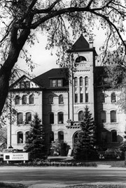
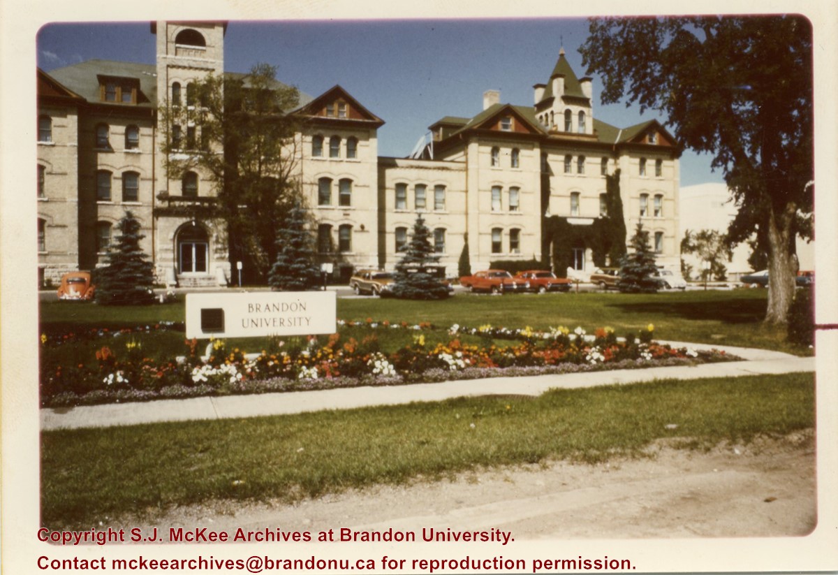
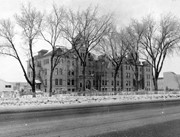
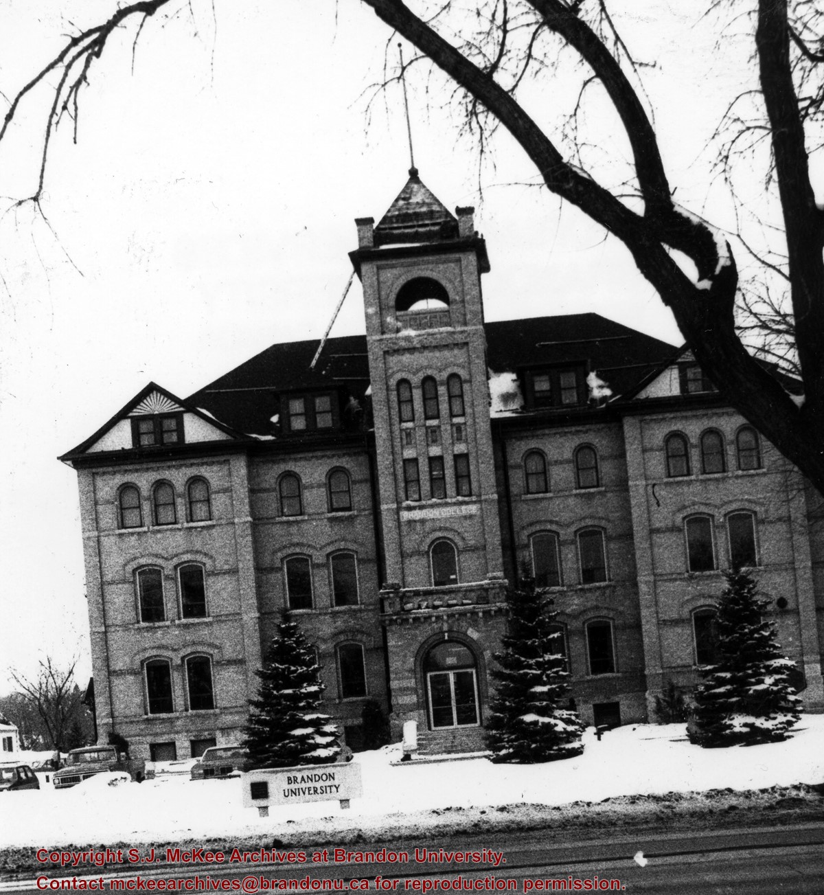
View is west north west from 18th Street. Photograph shows the Brandon College Building, Clark Hall, and the Brandon University sign on the front lawn.
Images
Show Less

Brandon College Building and Clark Hall

http://archives.brandonu.ca/en/permalink/descriptions806
Part Of
Brandon University Photograph Collection
Description Level
Item
GMD
graphic
Date Range
c. 1909
Part Of
Brandon University Photograph Collection
Description Level
Item
Series Number
2.2
Item Number
2.2.27
GMD
graphic
Date Range
c. 1909
Physical Description
6" x 4" (b/w)
Scope and Content
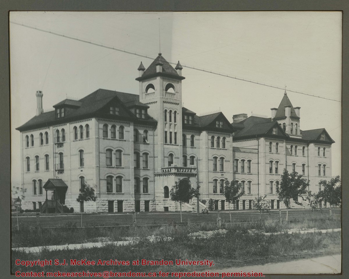
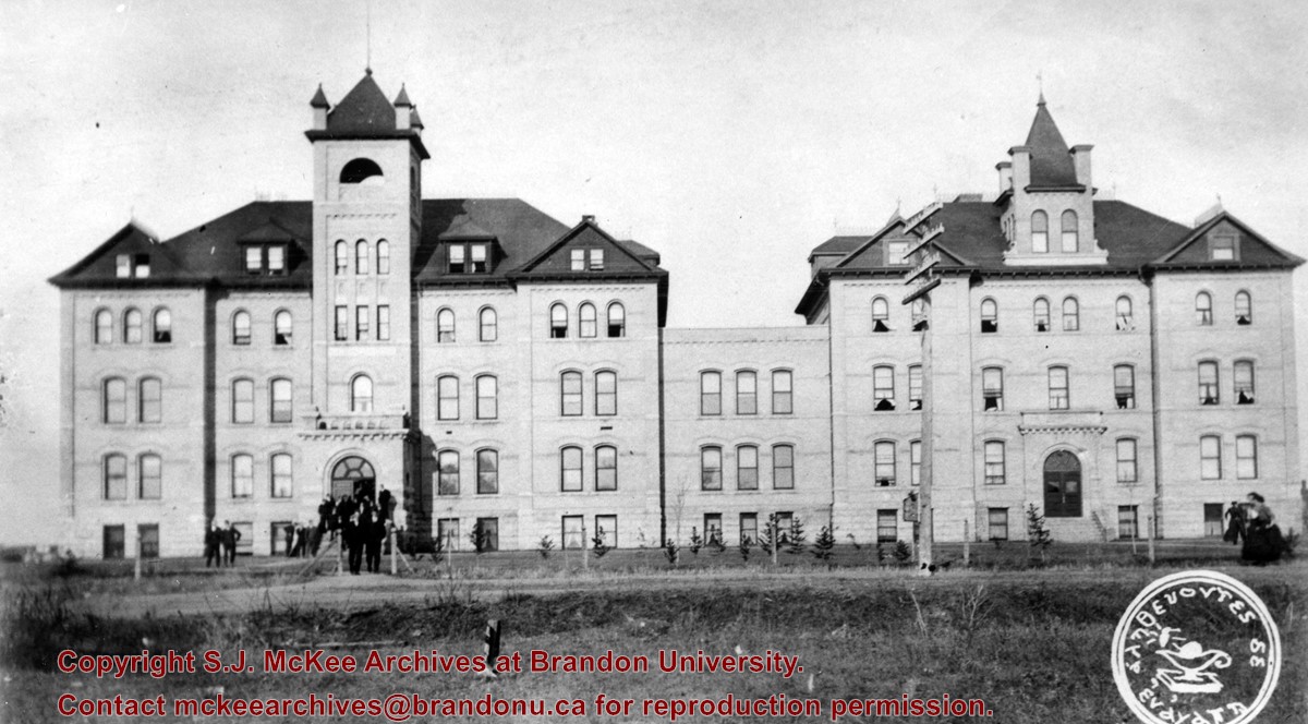
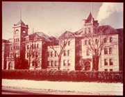
View is west from approximately 18th Street. Photograph was taken during the McDiarmid (1900-1912) era and shows the Brandon College Building and Clark Hall. Students are visible on the lawn and steps.
Notes
Negative enclosed.
Images
Show Less

Brandon College Building and Clark Hall

http://archives.brandonu.ca/en/permalink/descriptions825
Part Of
Brandon University Photograph Collection
Description Level
Item
GMD
graphic
Date Range
c. 1968
Part Of
Brandon University Photograph Collection
Description Level
Item
Series Number
2.2
Item Number
2.2.7
GMD
graphic
Date Range
c. 1968
Physical Description
4.5" x 3.5" (b/w)
Scope and Content
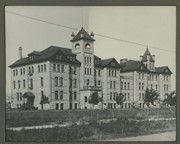
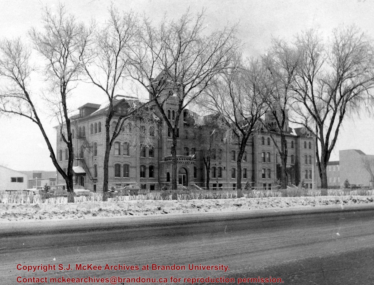
View is northwest from the east side of 18th Street. Photograph shows the Brandon College Building and Clark Hall in winter. The Education Building is visible in the background.
Images
Show Less

Brandon College Building and Clark Hall

http://archives.brandonu.ca/en/permalink/descriptions827
Part Of
Brandon University Photograph Collection
Description Level
Item
GMD
graphic
Date Range
c. 1960s
Part Of
Brandon University Photograph Collection
Description Level
Item
Series Number
2.2
Item Number
2.2.43
GMD
graphic
Date Range
c. 1960s
Physical Description
10" x 8" (colour)
Scope and Content
View is west southwest from 18th Street. Photograph shows the Brandon College Building and Clark Hall in winter.
Images
Show Less

Brandon College Building and Clark Hall

http://archives.brandonu.ca/en/permalink/descriptions848
Part Of
Brandon University Photograph Collection
Description Level
Item
GMD
graphic
Date Range
May 1978
Part Of
Brandon University Photograph Collection
Description Level
Item
Series Number
2.2
Item Number
2.2.20
GMD
graphic
Date Range
May 1978
Physical Description
5" x 3.5" (colour)
Scope and Content
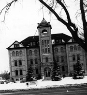
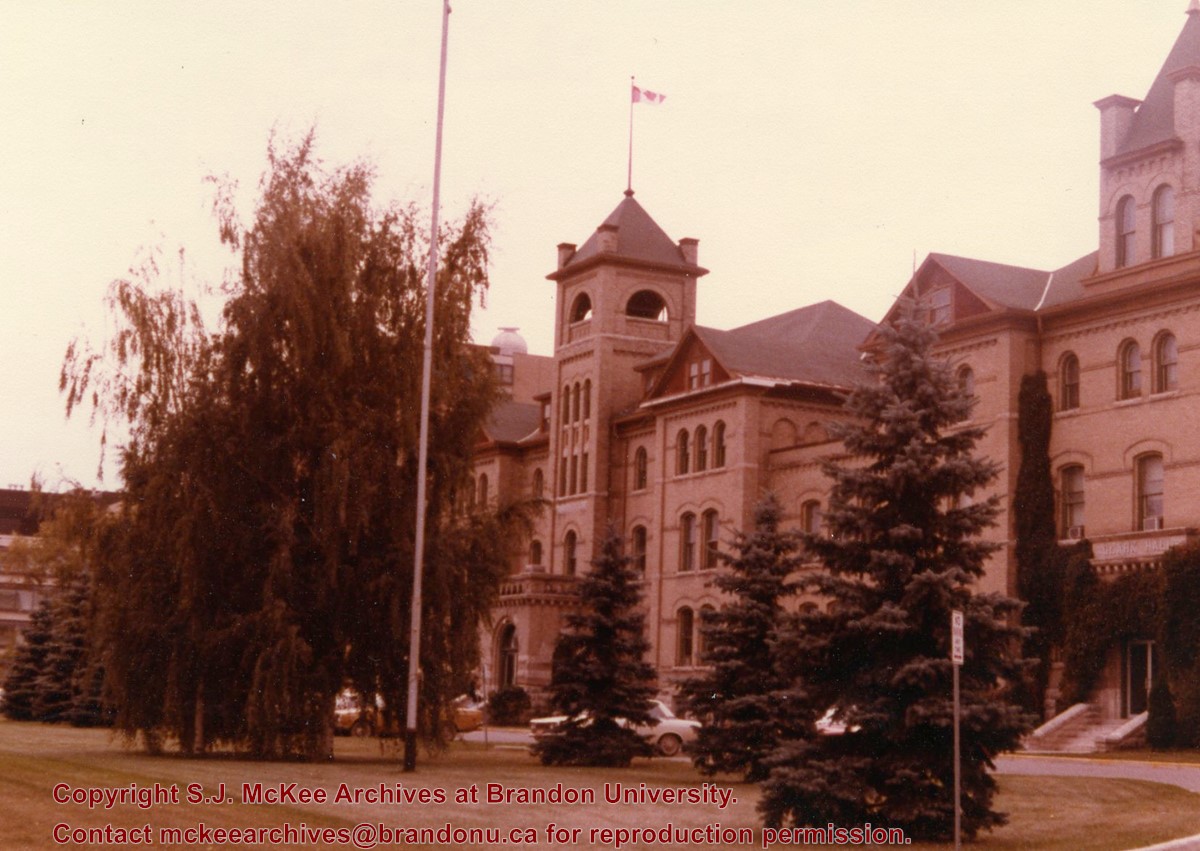
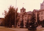
View is southwest from where the driveway meets 18th Street. Photograph shows the Brandon College Building (flying the Canadian flag on the tower), Clark Hall and the front lawn.
Images
Show Less

77 records – page 1 of 4.