Skip header and navigation

Revise Search

20 records – page 1 of 1.

Aerial view: Brandon College

http://archives.brandonu.ca/en/permalink/descriptions594
Part Of
Brandon University Photograph collection
Description Level
Item
GMD
graphic
Date Range
[fall 1964?]
Part Of
Brandon University Photograph collection
Description Level
Item
Series Number
2.1
Item Number
BUPC 2.1.2
GMD
graphic
Date Range
[fall 1964?]
Physical Description
5" x 4" (b/w)
Scope and Content
Brandon College looking south from 19th Street. Photograph was taken after Flora Cowan Hall was built but before construction of the Education Building.
Subject Access
aerial photographs
campus photographs
campus buildings
Brandon streets
Images
Show Less

Aerial view - Brandon College looking southwest

http://archives.brandonu.ca/en/permalink/descriptions601
Part Of
Brandon University Photograph collection
Description Level
Item
GMD
graphic
Date Range
[1963-1966]
Part Of
Brandon University Photograph collection
Description Level
Item
Series Number
2.1
Item Number
BUPC 2.1.8
GMD
graphic
Date Range
[1963-1966]
Physical Description
5" x 4" (b/w)
Scope and Content
Image shows the Brandon College campus from 17th Street looking southwest. The photo was taken after the completion of the original Music Building in 1963, but construction of the Education Building. Also visible are a number of properties on the 200 block of 18th Street and the 200 block of 20th Street.
Subject Access
aerial photographs
campus photographs
campus buildings
Brandon streets
Images
Show Less

Aerial view: Brandon College from 23rd Street

http://archives.brandonu.ca/en/permalink/descriptions602
Part Of
Brandon University Photograph collection
Description Level
Item
GMD
graphic
Date Range
[1963-1966]
Part Of
Brandon University Photograph collection
Description Level
Item
Series Number
2.1
Item Number
BUPC 2.1.9
GMD
graphic
Date Range
[1963-1966]
Physical Description
5" x 4" (b/w)
Scope and Content
Image is looking east northeast from approximately the 300 block of 23rd Street between Lorne and Louise Avenues. Photograph shows the Brandon College campus after the opening of the original Music Building in 1963, but before the construction of the Education Building in 1966. A number of house on the 300 blocks of 22nd and 21st Streets are visible in the foreground, with the A.E. McKenzie Seed Co., the Prince Edward Hotel and various grain elevators on the horizon.
Subject Access
aerial photographs
campus photographs
campus buildings
Brandon streets
Grain elevators
Images
Show Less

A.E. McKenzie Building construction

http://archives.brandonu.ca/en/permalink/descriptions627
Part Of
Brandon University Photograph collection
Description Level
Item
GMD
graphic
Date Range
[1959-1960]
Part Of
Brandon University Photograph collection
Description Level
Item
Series Number
2.4
Item Number
BUPC 2.4.6
GMD
graphic
Date Range
[1959-1960]
Physical Description
5" x 7" (b/w)
Scope and Content
Photograph is looking northeast (?) and shows the construction of the A.E. McKenzie Building (Library and Arts Building) during the winter.
Subject Access
campus buildings
Images
Show Less
Part Of
Brandon and Area Photograph Collection
Description Level
Item
GMD
graphic
Date Range
c. 1900
Part Of
Brandon and Area Photograph Collection
Creator
Photographer: W.A. Martel & Son
Description Level
Item
Series Number
5
Item Number
BAPC 5.11
GMD
graphic
Date Range
c. 1900
Physical Description
4" x 5.5" (b/w)
Physical Condition
Very good
History / Biographical
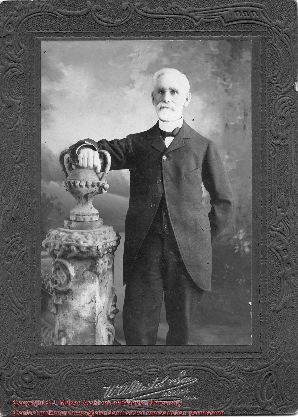
William Currie was born on February 28, 1834 in Lanark County, ON. In 1860, he moved to St. Mary's, where he worked in mercantile and grain businesses until 1879, when he emigrated to Manitoba. The following year, he took up homesteading along the Assiniboine River, at a site known as Currie's Landing. He received and forwarded frieght from steamboats travelling the river. From 1893-1902, he served as baliff for the Brandon District, before resigning and moving to Brandon where he engaged in the real estate and fire insurance business. Currie married Ellen Creighton of Blanchard, ON in 1861. Together they had six chrildren: Robert Wilson Currie, Margaret Anne Currie, Harriet Ellen Currie, William James Currie, James Weldon Currie, and Lottie Louise Currie. William Currie died on March 30, 1931 in Brandon, MB.
Scope and Content
Item is a studio portrait of William Currie.
Notes
History/Bio information taken from the Manitoba Historical Society website (http://www.mhs.mb.ca/docs/people/currie_w.shtml)
Name Access
William Currie
Currie's Landing
Subject Access
portraits
Pioneers
Storage Location
BAPC photograph drawer
Images
Show Less

Smith & Burton, grocers

http://archives.brandonu.ca/en/permalink/descriptions14315
Part Of
Brandon and Area Photograph Collection
Description Level
Item
GMD
graphic
Date Range
c. 1906
Part Of
Brandon and Area Photograph Collection
Creator
Photographer: Wilson & Larkin (Toronto)
Description Level
Item
Series Number
2
Item Number
BAPC 2.41
GMD
graphic
Date Range
c. 1906
Physical Description
6.5" x 4.25" (b/w)
Material Details
On backing board (7.25" x 5.5")
Physical Condition
Very poor. Item has been broken in half on a diagonal from top to botton. Upper right corner is missing. Various tape stains and some tape residue on the bottom left.
History / Biographical
Lottie Louisa Currie was born on September 9, 1876 in St. Mary's, Perth, ON, to William and Eleanor Currie. She came to the Brandon area with her family in the 1880s. Currie worked as a bookkeeper and stenographer for Smith & Burton, from at least 1906 until the business ceased operations in 1917. Currie continued working in bookkeeping and accounts, first for Brandon Gas & Power Co., then for the Manitoba Power Commission. She appears to have retired around 1942. She is not listed as living in Brandon between 1943-1945, but was once again a resident by 1947. Currie was a member of the First Presbyterian Church, a charter member of the Brandon Business and Professional Women's Club and in 1916, she passed her examinations for the St. John's Ambulance Association. Lottie Louisa Currie died on November 25, 1972 in Brandon, MB. 
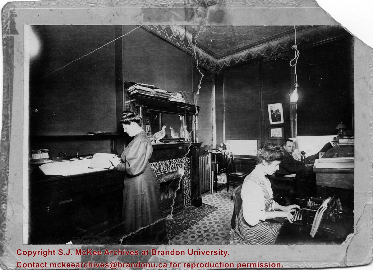
Smith & Burton, a grocery store that also had mail order and china departments, was founded by E.B. Smith and John Burton in the 1886. It was housed at a few locations in downtown Brandon; their location at 829 Rosser Avenue is the one that mostly likely appears in the photograph.
Scope and Content
Item is a portrait of office employees at Smith & Burton, grocers. Lottie Currie, daughter of William Currie, is shown standing on the left.
Name Access
Smith & Burton
Lottie Currie
Subject Access
commerical buildings
grocers
downtown
office workers
Pioneers
Storage Location
BAPC photograph drawer
Related Material
BAPC 5.11 William Currie
Images
Show Less

Yaeger's Furs Dionne quintuplets window display

http://archives.brandonu.ca/en/permalink/descriptions14317
Part Of
Brandon and Area Photograph Collection
Description Level
Item
GMD
graphic
Date Range
1934
Part Of
Brandon and Area Photograph Collection
Creator
Brandon Sun Publishing Co.
Description Level
Item
Series Number
2
Item Number
BAPC 2.43
GMD
graphic
Date Range
1934
Physical Description
10.25" x 8" (b/w)
History / Biographical
Gustave Bellegro “Gus” Yaeger was born on July 10, 1878 at Genoa, Italy. The son of Swiss parents, he immigrated to the United States, working in West Virginia then North Dakota before arriving in Brandon, MB in 1910. He worked at various jobs before opening Yaeger's Furs, a fur-coat factory and retail store at 602 Rosser Avenue, in 1919. Yaeger married Sarah Ellen Williams (1883-1966) of Big Rock, Idaho in 1907. They had two children: Karl Williams Yaeger (1908-1975) and Barbara Yaeger (m. H.H. Ricketts). Gus Yaeger died on March 25, 1942 in Brandon, MB. His son carried on the business after his death before selling it to one of the managers in 1969. 
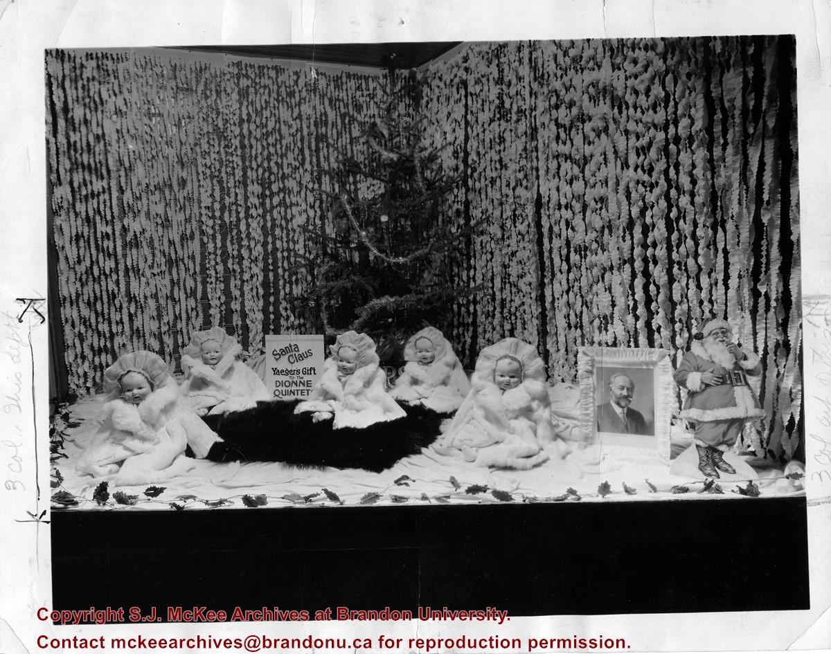
The Dionne quintuplets, born May 28, 1934, were the first quintuplets known to have survived their infancy. They were born just outside Callandar, ON.
Scope and Content
Item is a photograph of the Yaeger's Furs Dionne quintuplets Christmas window display. The display features five dolls dressed in fur coats and bonnets, a framed photo of Gus Yaeger, a Christmas tree and a cardboard Santa.
Notes
History/Bio information taken from the Manitoba Historical Society website (http://www.mhs.mb.ca/docs/people/yaeger_gb.shtml)
Name Access
Yaeger's Furs
Gus Yaeger
Dionne quintuplets
Subject Access
downtown
window displays
commercial buildings
businesses
quintuplets
quints
Storage Location
BAPC photograph drawer
Images
Show Less

Aerial view - Brandon University campus

http://archives.brandonu.ca/en/permalink/descriptions7989
Part Of
Brandon University Photograph collection
Description Level
Item
GMD
graphic
Date Range
c. 2000
Part Of
Brandon University Photograph collection
Creator
Photograph commissioned by Brandon University and taken by Yourview Aerial Scenics Ltd.
Description Level
Item
Series Number
2.1
Item Number
BUPC 2.1.55
GMD
graphic
Date Range
c. 2000
Physical Description
6" x 4" (colour)
Scope and Content
View is southwest from approximatley 16th Street between Princess and Rosser Avenues. Photograph shows the Brandon University campus, as well as surrounding residential blocks, including Flemming, J.R. Reid and Vincent Massey schools.
Subject Access
aerial photographs
campus photographs
campus buildings
Brandon streets
Images
Show Less

Aerial view - Brandon University campus

http://archives.brandonu.ca/en/permalink/descriptions7990
Part Of
Brandon University Photograph collection
Description Level
Item
GMD
graphic
Date Range
c. 2000
Part Of
Brandon University Photograph collection
Creator
Photograph commissioned by Brandon University and taken by Yourview Aerial Scenics Ltd.
Description Level
Item
Series Number
2.1
Item Number
BUPC 2.1.56
GMD
graphic
Date Range
c. 2000
Physical Description
6" x 4" (colour)
Scope and Content
View is west southwest from approximatley 16th Street between Princess and Lorne Avenues. Photograph shows the Brandon University campus, as well as surrounding residential blocks between 16th and 23rd Streets, Princess and Louise Avenues..
Subject Access
aerial photographs
campus photographs
campus buildings
Brandon streets
Images
Show Less

Aerial view - Brandon University campus

http://archives.brandonu.ca/en/permalink/descriptions7991
Part Of
Brandon University Photograph collection
Description Level
Item
GMD
graphic
Date Range
c. 2000
Part Of
Brandon University Photograph collection
Creator
Photograph commissioned by Brandon University and taken by Yourview Aerial Scenics Ltd.
Description Level
Item
Series Number
2.1
Item Number
BUPC 2.1.57
GMD
graphic
Date Range
c. 2000
Physical Description
6" x 4" (colour)
Scope and Content
View is west from approximatley 17th Street between Lorne and Louise Avenues. Photograph shows a portion of the Brandon University campus (excluding the Education Building and anything north of it), as well as surrounding residential blocks from approximatley 17th Street to 22nd Street.
Subject Access
aerial photographs
campus photographs
campus buildings
Brandon streets
Images
Show Less

Aerial view - Brandon University campus

http://archives.brandonu.ca/en/permalink/descriptions7992
Part Of
Brandon University Photograph collection
Description Level
Item
GMD
graphic
Date Range
c. 1990
Part Of
Brandon University Photograph collection
Description Level
Item
Series Number
2.1
Item Number
BUPC 2.1.58
GMD
graphic
Date Range
c. 1990
Physical Description
5" x 3.5" (colour)
Scope and Content
View is west northwest from approximatley 16th Street and Louise Avenue. Photograph shows the Brandon University campus, prior to the Library Extension, and a large portion of the city to the west of the campus.
Subject Access
aerial photographs
campus photographs
campus buildings
Brandon streets
Images
Show Less

Aerial view - Brandon University campus

http://archives.brandonu.ca/en/permalink/descriptions7993
Part Of
Brandon University Photograph collection
Description Level
Item
GMD
graphic
Date Range
c. 1990
Part Of
Brandon University Photograph collection
Description Level
Item
Series Number
2.1
Item Number
BUPC 2.1.59
GMD
graphic
Date Range
c. 1990
Physical Description
5" x 3.5" (colour)
Scope and Content
View is northwest from approximatley 16th Street and Louise Avenue. Photograph shows the Brandon University campus, prior to the Library Extension, and a large portion of the city to the west of the campus.
Subject Access
aerial photographs
campus photographs
campus buildings
Brandon streets
Show Less
Part Of
Brandon University Photograph collection
Description Level
Item
GMD
graphic
Date Range
May 12, 1992
Part Of
Brandon University Photograph collection
Description Level
Item
Series Number
2.1
Item Number
BUPC 2.1.62
GMD
graphic
Date Range
May 12, 1992
Physical Description
5.75" x 3.75" (colour)
Scope and Content
Photograph shows a backhoe digging a sewer hole near the sidewalk between the Brandon College Building and the Citizens' Science Building. The Knowles-Douglas Students' Union Centre, John R. Brodie Science Centre and a portion of the driveway are visible in the background.
Subject Access
campus photographs
campus buildings
campus construction
Images
Show Less

Brandon University campus

http://archives.brandonu.ca/en/permalink/descriptions7997
Part Of
Brandon University Photograph collection
Description Level
Item
GMD
graphic
Date Range
c. 1996
Part Of
Brandon University Photograph collection
Creator
Photographer: Sandy Black
Description Level
Item
Series Number
2.1
Item Number
BUPC 2.1.63
GMD
graphic
Date Range
c. 1996
Physical Description
6" x 4" (colour)
Scope and Content
View is northwest from the roof of the John R. Brodie Science Centre. Photograph shows the roof of the Knowles Douglas Students' Union Centre, the Citizens' Science Building, and the Brandon College Building and Clark Hall during renovation.
Subject Access
campus photographs
campus buildings
campus construction
Images
Show Less

Brandon University campus

http://archives.brandonu.ca/en/permalink/descriptions7999
Part Of
Brandon University Photograph collection
Description Level
Item
GMD
graphic
Date Range
c. 1993
Part Of
Brandon University Photograph collection
Description Level
Item
Series Number
2.1
Item Number
BUPC 2.1.65
GMD
graphic
Date Range
c. 1993
Physical Description
4" x 6" (colour)
Scope and Content
View is southwest from the roof of the George T. Richardson Centre. Photograph shows the curved glass wall of the John E. Robbins Library, the walkway between the Library and the Dining Hall, the Dining Hall and Darrach Hall.
Subject Access
campus photographs
campus buildings
Images
Show Less

Brandon University campus construction

http://archives.brandonu.ca/en/permalink/descriptions8000
Part Of
Brandon University Photograph collection
Description Level
Item
GMD
graphic
Date Range
c. 1996
Part Of
Brandon University Photograph collection
Creator
Photographer: Sandy Black
Description Level
Item
Series Number
2.1
Item Number
BUPC 2.1.66
GMD
graphic
Date Range
c. 1996
Physical Description
6" x 4" (colour)
Scope and Content
View is southeast from the roof of the A.E. McKenzie Building. Photograph shows the construction of the extension of Clark Hall and the skywalk.
Subject Access
campus photographs
campus buildings
campus construction
Images
Show Less

Brandon University campus construction

http://archives.brandonu.ca/en/permalink/descriptions8001
Part Of
Brandon University Photograph collection
Description Level
Item
GMD
graphic
Date Range
c. 1996
Part Of
Brandon University Photograph collection
Creator
Photographer: Sandy Black
Description Level
Item
Series Number
2.1
Item Number
BUPC 2.1.67
GMD
graphic
Date Range
c. 1996
Physical Description
6" x 4" (colour)
Scope and Content
View is north probably from the roof of McMaster Hall. Photograph shows the construction of the extension of Clark Hall and the skywalk.
Subject Access
campus photographs
campus buildings
campus construction
Images
Show Less

Brandon University campus construction

http://archives.brandonu.ca/en/permalink/descriptions8002
Part Of
Brandon University Photograph collection
Description Level
Item
GMD
graphic
Date Range
c. 1996
Part Of
Brandon University Photograph collection
Creator
Photographer: Sandy Black
Description Level
Item
Series Number
2.1
Item Number
BUPC 2.1.68
GMD
graphic
Date Range
c. 1996
Physical Description
6" x 4" (colour)
Scope and Content
View is north probably from the roof of McMaster Hall. Photograph shows the construction of the new roof on Clark Hall and the Brandon College Building.
Subject Access
campus photographs
campus buildings
campus construction
Images
Show Less

Brandon University campus construction

http://archives.brandonu.ca/en/permalink/descriptions8003
Part Of
Brandon University Photograph collection
Description Level
Item
GMD
graphic
Date Range
c. 1996
Part Of
Brandon University Photograph collection
Description Level
Item
Series Number
2.1
Item Number
2.1.69
GMD
graphic
Date Range
c. 1996
Physical Description
6" x 4" (colour)
Scope and Content
View is southwest from Clark Hall. Photograph shows the construction of the extension of Clark Hall.
Subject Access
campus photographs
campus buildings
campus construction
Images
Show Less

Brandon University campus construction

http://archives.brandonu.ca/en/permalink/descriptions8004
Part Of
Brandon University Photograph collection
Description Level
Item
GMD
graphic
Date Range
c. 1996
Part Of
Brandon University Photograph collection
Creator
Photographer: Sandy Black
Description Level
Item
Series Number
2.1
Item Number
BUPC 2.1.70
GMD
graphic
Date Range
c. 1996
Physical Description
6" x 4" (colour)
Scope and Content
View is north probably from the roof of McMaster Hall. Photograph shows the construction of the extension to Clark Hall and the skywalk. Also visible are the A.E. McKenzie Building, the Brandon College Building, the Education Building, the original Music Building and the Western Manitoba Centennial Auditorium, as well as the walkway that runs north between the buildings and the courtyard.
Subject Access
campus photographs
campus buildings
campus construction
Show Less

20 records – page 1 of 1.