View is north northeast. Photograph shows the Brandon College Building in the foreground with the Education Building and North Hill in the background. Photo was taken from the roof of McMaster Hall.
View is northwest, taken from the John R. Brodie Science Centre. Photograph shows: Citizens' Science Building in the foreground, the Brandon College Building and Clark Hall in the background, as well as the driveway in front of the buildings.
BRANDON COLLEGE BUILDING
The construction of the Brandon College Building, also known as the Original Building, was primarily financed by Mr. and Mrs. William Davies, a Toronto based Baptist meat packer, and his sister Mrs. Emily Davies, also of Toronto, who pledged $5,000 a year for five years to the new Baptist College. Four city blocks between 18th and 20th streets were purchased for the College campus and the tender of Messrs. T.M. Harrington of Winnipeg was accepted in the spring of 1900; Mr. Hugh McCowan of Winnipeg appointed as architect. Mrs. Davies laid the cornerstone for the Brandon College Building on July 13, 1900.
The Brandon College Building was conceived as a substantial five story brick structure with a stone basement. The Tyndall Manitoba quarries, located thrity miles northeast of Winnipeg, supplied the stone and presented the College with the stone steps at the main entrance. The basement contained the dining room, kitchen, laundry, furnace room, a science laboratory, and maids' rooms. The first floor housed the reception room, office, library, four classrooms and the teachers' cloak rooms. The second floor had five classrooms, a reading room, five rooms for resident students and a resident teacher. Teachers' rooms and seventeen rooms for students comprised the third floor; and additional thirteen rooms for residents took up the fourth floor. The residence was to house 70 men. The total cost of the building and furnishings was $44,000. The Brandon College Building was ready for occupancy by October 1, 1901.
CLARK HALL
The cornerstone of Clark Hall was laid by Mrs. A.P. McDiarmid, wife of the Principal of Brandon College, on May 24, 1906. The residence was officially opened on Thanksgiving Day, October 18, of the same year. The construction of the building grew our of a demand for a ladies' college. A canvass made in Eastern Canada had resulted in subscriptions totaling $10,000. When Dr. McDiarmid reported the results of the canvass to the Chairman of the Board, Dr. C.W. Clark of Winnipeg, Clark proposed that he and his wife be allowed to provided the balance of the funds, some $30,000. While presenting the building at the opening ceremony, Clark stated that the reason for his donation was his belief in the power of cultured womanhood - he believed "that refined and Christian mothers were the strength of a nation and that he wished to see in Brandon a chool of learning for women in which every Christian virtue and grace might be illustrated."
Clark Hall was built immediately north of the Brandon College Building and was connected to it by classrooms and the iron door with its door bell, which was rung by gentlemen before being admitted. It is a five story brick building, with fittings of imported Georgia pine. In the basement was the gymnasium, studios and maids' rooms. On the main floor was a spacious reception room furnished by the Honorable A.C. Rutherford, the Premier of Alberta and the Lady Principal's suite, furnished by Mrs. N. Wolverston, wife of the treaurer of the College Board. Music studios and the offices of the resident matron were also on the main floor. The second and third floors were dormitories. The fourth floor was meant to be art studios, but due to registration demands, it was divided into students' rooms. The residence was designed to house fifty students and seven teachers. Piano practice areas were also designated on the west side of the building and on the groundlevel half way between the basement and the first floor.
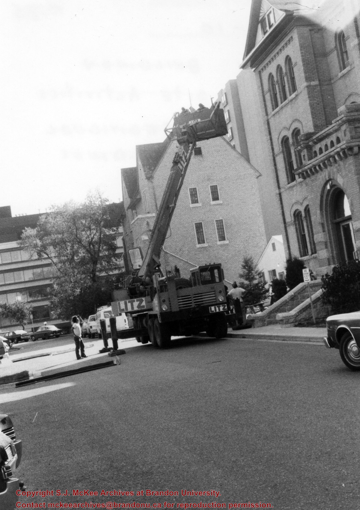
BRANDON COLLEGE BUILDING AND CLARK HALL RESTORATION PROJECT
By the early 1990s, it was clear that major reconstruction work on the Brandon College Building and Clark Hall was necessary if the buildings were to remain in use. The alternative was to demolish both buildings and construct a new central administrative structure for the campus. Because of the historic character of the two original campus buildings, the decision was taken to mount a complete restoration of the structures that involved a complete removal of everything except for the surrounding brick fascade and the construction of new buildings within the old external walls. This project was financed by the Provincial government of Manitoba, who granted the University approximatley 10 million dollars. The Chief Architect for the restoration was George Cibinal. Work began in 1996 and was completed by the fall of 1997. In addition to the restoration of the Brandon College Building and Clark Hall, a new entrance was built on the west side of the buildings, as well as an addition to Clark Hall, which included a skywalk connecting it to the A.E. McKenzie Building.
Scope and Content
Sub-series consists of photographs of the Brandon College Building and Clark Hall.
Notes
History/Bio information was taken from Brandon College: A History, 1899-1967 by C.G. Stone and F. Joan Garnett (Brandon, Manitoba: Brandon University, 1969), chapters 2 and 3. Tom Mitchell provided history/bio information on the restoration project.
Photograph is looking northwest probably from the John R. Brodie Science Centre and shows the Citzens' Science Building, the Brandon College Building, Clark Hall and a portion of the driveway and grounds in front of the buildings.
View is southwest from the John R. Brodie Science Centre. Photograph shows: Flora Cowan Hall, the Brandon University Gymnasium, Darrach Hall, the Quill trailer and the Jeff Umphrey Centre.
View is southwest from approximately Princess Avenue and 17th Street. Photograph shows the Brandon University campus in fall, as well as the southwest portion of the city.
View is south southwest from approximatley the east corner of 18th Street and Princess Avenue. Photograph shows the Brandon University campus, Kinsmen Stadium, Earl Oxford school and a number of residential blocks, particularly southwest of 18th Street.
View is southeast from approximatley 23rd Street and Rosser Avenue. Photograph shows the Brandon University campus, Kinsmen Stadium, Earl Oxford school, the Fair Grounds (including the Grandstand and Racetrack) and a number of residential blocks, particularly in the southeast part of the city.
View is west from 17th Street between Louise and Princess Avenues. Photograph shows the Brandon University Campus, Fleming School and Coronation Park, as well as a number of residential blocks.
View is southwest from the 200 block of 17th Street. Photograph shows the Brandon University campus, Kinsmen Stadium, Fleming School and a number of residential blocks.
View is south southeast from approsimatley Rosser Avenue and 21st Street. Photograph shows the Brandon University campus, Kinsmen Stadium, Earl Oxford School, the Fair Grounds (including the Grand Stand and Race Track), and a number of residential blocks.
View is south southwest from approximatley the southwest corner of 18th Street and Princess Avenue. Photograph shows the University campus, Kinsmen Stadium, Earl Oxford School and residential blocks.
View is west from 17th Street between Louise and Princess Avenues to approximalety 25th Street. Photograph shows the University campus, Fleming School, Coronation Park and residential blocks.
A problem during development has obscured a portion of Kinsmen Stadium and the southeast corner of the campus.
Scope and Content
View is north from Victoria Avenue between 18th and 20th Streets to the railway tracks. Photograph shows Kinsmen Stadium, the College campus and a number of residential blocks.
View is northeast from approximately the southwest corner of Victoria Avenue and 22nd Street to the Assiniboine River near 1st Street. Photograph shows the College campus, Kinsmen Stadium, residential blocks, downtown and the railway tracks.
View is southeast from north of the corner of Princess Avenue and 22nd Street to approximatley Brandon Avenue. Photograph shows the University campus, Kinsmen Stadium, Earl Oxford School, and residential blocks. Brandon Collegiate Institute (BCI) is visible in the upper left corner.


