Skip header and navigation

Revise Search

895 records – page 1 of 45.

Archibald E. Wilson fonds

http://archives.brandonu.ca/en/permalink/descriptions4809
Part Of
Archibald E. Wilson fonds
Description Level
Fonds
GMD
textual records
Date Range
1895-1932; 1971
Accession Number
18-2000
Other Title Info
RG 5 Western Manitoba Manuscript Collection
Part Of
Archibald E. Wilson fonds
Description Level
Fonds
Accession Number
18-2000
GMD
textual records
Date Range
1895-1932; 1971
Physical Description
2 cm
History / Biographical
Archibald E. Wilson was the son of Reverend E.F. Wilson and the husband of St. Clair Vidal Wilson. Rev. E.F. Wilson was at one time in charge of the Shingwauk and Wawanosh Homes at Sault Ste. Marie. Rev. E.F. Wilson moved to Elkhorn, Manitoba in 1888, to establish an educational home for Indian children. He was joined by his son, Archibald E. Wilson who was, in 1890, appointed assistant to the superintendent. A.E. Wilson became Principal of the Indian Industrial School in 1892. His wife served as Matron of the girls departments. Togerher they had three daughters: E.F. Metita, Winifred St. Clair and Murial Grace, as well as two sons: Edward Vidal, and St. Clair Vidal Wilson. Archibald Wilson and his family lived in Elkhorn, Manitoba during the years 1892 to 1918 while he was principal. At the beginning of his term as Principal there were 12 students enrolled; enrollment reached as high as 95 students, representing eight different nations. In February of 1918, the government withdrew funding and the school closed. In September of 1918, Wilson left Elkhorn to take up his new position as a clerk at an Indian Reserve near Gleichen, Alberta. During its years of operation, the Elkhorn Industrial School included an Athletic department, a curling team and a boys' football team. Students studied carpentry, shoemaking, harness making, tailoring, knitting and sewing. In 1893, the school was presented with a large Canadian flag for being the best Industrial School in Manitoba and the Territories. In November of 1893, a brass band was established, which provided music for the local Anglican Chruch. After a fire demolished most of the school in 1895, Wilson convinced the Federal Department of Indian Affairs to rebuild the school. In 1899, the Elkhorn Industrial School was reopened.
Custodial History
Most of this fonds was at one time in the possession of Principal A.E. Wilson. After Wilson passed away the pieces of the fonds were kept by one of his daughters, Winifred St. Clair Wilson, now deceased. Winifred married Mr. Frank Clark, M.D. and kept the fonds when she moved to Vancouver B.C. and then to Calgary, Alberta. Winifred Clark eventually donated the fonds to the McKee Archives.
Scope and Content
Fonds includes four journals, one testimonial and one newspaper article. The journals include: the ‘7th Annual Report of the Washakada Indian Homet 1895-1896,' written by Principal A.E. Wilson; ‘The Greater Britain Messenger’ September and October 1899, which includes the article ‘The Elkhorn Home, Manitoba;’ ‘The National Monthly of Canada’ September 1902, which includes the article ‘Indian Children at Home;’ and the Centeneray Number (March-April 1932) issue of ‘The Algoma Missionary News,’ which includes an article giving information about Rev. E.F. Wilson and his missionary work. Fonds also includes an article from the November 19, 1971 edition of The Vancouver Sun, entitled "Leisure's Book Reviews," which discusses Indigenous publications in Canada. The testimonial that is included in the fonds, was given to Archibald Wilson upon his departure from Elkhorn. There are 28 subscribers to the testimonial and it is dated September 19, 1918.
Notes
The Wilsons are discussed in J.R. Miller's "Skyscrapers Hide the Heavens: A History of Indian-White Relations in Canada," Miller's "Shingwauk's vision :a history of native residential schools" and John S. Milloy's "A National Crime: The Canadian Government and the Residential School System 1879-1986." Description by Christy Henry.
Storage Location
2000 accessions
Show Less

Brandon University campus

http://archives.brandonu.ca/en/permalink/descriptions8026
Part Of
Aerial views and campus photographs
Description Level
Item
GMD
graphic
Date Range
c. 1996
Part Of
Aerial views and campus photographs
Description Level
Item
Series Number
2.1
Item Number
2.1.93
GMD
graphic
Date Range
c. 1996
Physical Description
6" x 4" (colour)
Scope and Content
View is east northeast from the sidewalk on the southeast corner of the George T. Richardson Centre (John R. Robbins Library). Photographs shows the campus during winter, including the Physical Plant and Development H-Huts, as well as the Brandon College Building and Clark Hall after the majority of the renovations were completed.
Images
Show Less

Brandon University campus

http://archives.brandonu.ca/en/permalink/descriptions8027
Part Of
Aerial views and campus photographs
Description Level
Item
GMD
graphic
Date Range
c. 1985
Part Of
Aerial views and campus photographs
Description Level
Item
Series Number
2.1
Item Number
2.1.94
GMD
graphic
Date Range
c. 1985
Physical Description
5" x 3.5" (colour)
Scope and Content
View is southwest from 18th Street, just north of the Brandon University sign. Tken during the summer, the photograph shows the front lawn, a portion of the flower bed, the Citizens' Science Building, the Knowles Douglas Students' Union Centre, the John R. Brodie Science Centre and McMaster Hall.
Images
Show Less

Brandon University campus

http://archives.brandonu.ca/en/permalink/descriptions8028
Part Of
Aerial views and campus photographs
Description Level
Item
GMD
graphic
Date Range
c. 1980s
Part Of
Aerial views and campus photographs
Description Level
Item
Series Number
2.1
Item Number
2.1.95
GMD
graphic
Date Range
c. 1980s
Physical Description
5" x 3.5" (colour)
Scope and Content
View is northeast. Photograph shows the green space before the Library extension in 1993. Brandon College Building and the Development H-Hut in the background.
Images
Show Less

Brandon University campus

http://archives.brandonu.ca/en/permalink/descriptions8029
Part Of
Aerial views and campus photographs
Description Level
Item
GMD
graphic
Date Range
c. 1988
Part Of
Aerial views and campus photographs
Description Level
Item
Series Number
2.1
Item Number
2.1.96
GMD
graphic
Date Range
c. 1988
Physical Description
5" x 3.5" (colour)
Scope and Content
View is northwest from the roof of the John R. Brodie Science Centre. Photograph shows part of McMaster Hall, the H-Huts, the Citzens' Science Building, the Brandon College Building and Clark Hall, the driveway, the J.R.C. Evans Lecture Theatre, the A.E. McKenzie Building and the Queen Elizabeth II Music Building.
Images
Show Less

Brandon University campus

http://archives.brandonu.ca/en/permalink/descriptions8030
Part Of
Aerial views and campus photographs
Description Level
Item
GMD
graphic
Date Range
c. early 1990s
Part Of
Aerial views and campus photographs
Description Level
Item
Series Number
2.1
Item Number
2.1.97
GMD
graphic
Date Range
c. early 1990s
Physical Description
4" x 6" (b/w)
Scope and Content
View is north from the Knowles Douglas Students' Union Centre looking down the driveway toward Princess Avenue.
Images
Show Less

Brandon University campus

http://archives.brandonu.ca/en/permalink/descriptions8031
Part Of
Aerial views and campus photographs
Description Level
Item
GMD
graphic
Date Range
c. 1995
Part Of
Aerial views and campus photographs
Description Level
Item
Series Number
2.1
Item Number
2.1.98
GMD
graphic
Date Range
c. 1995
Physical Description
6" x 4" (colour)
Scope and Content
View is northwest from the sidewalk on the west side of 18th Street. Photograph shows the John R. Brodie Science Centre sign, McMaster Hall and its entrance, the lawn in from of McMaster Hall, a portion of the Knowles Douglas Students' Union Centre and the Citizens' Science Building.
Images
Show Less

Brandon University campus

http://archives.brandonu.ca/en/permalink/descriptions8032
Part Of
Aerial views and campus photographs
Description Level
Item
GMD
graphic
Date Range
c. 2000
Part Of
Aerial views and campus photographs
Creator
Photographer: Sandy Black
Description Level
Item
Series Number
2.1
Item Number
2.1.99
GMD
graphic
Date Range
c. 2000
Physical Description
6" x 4" (colour)
Scope and Content
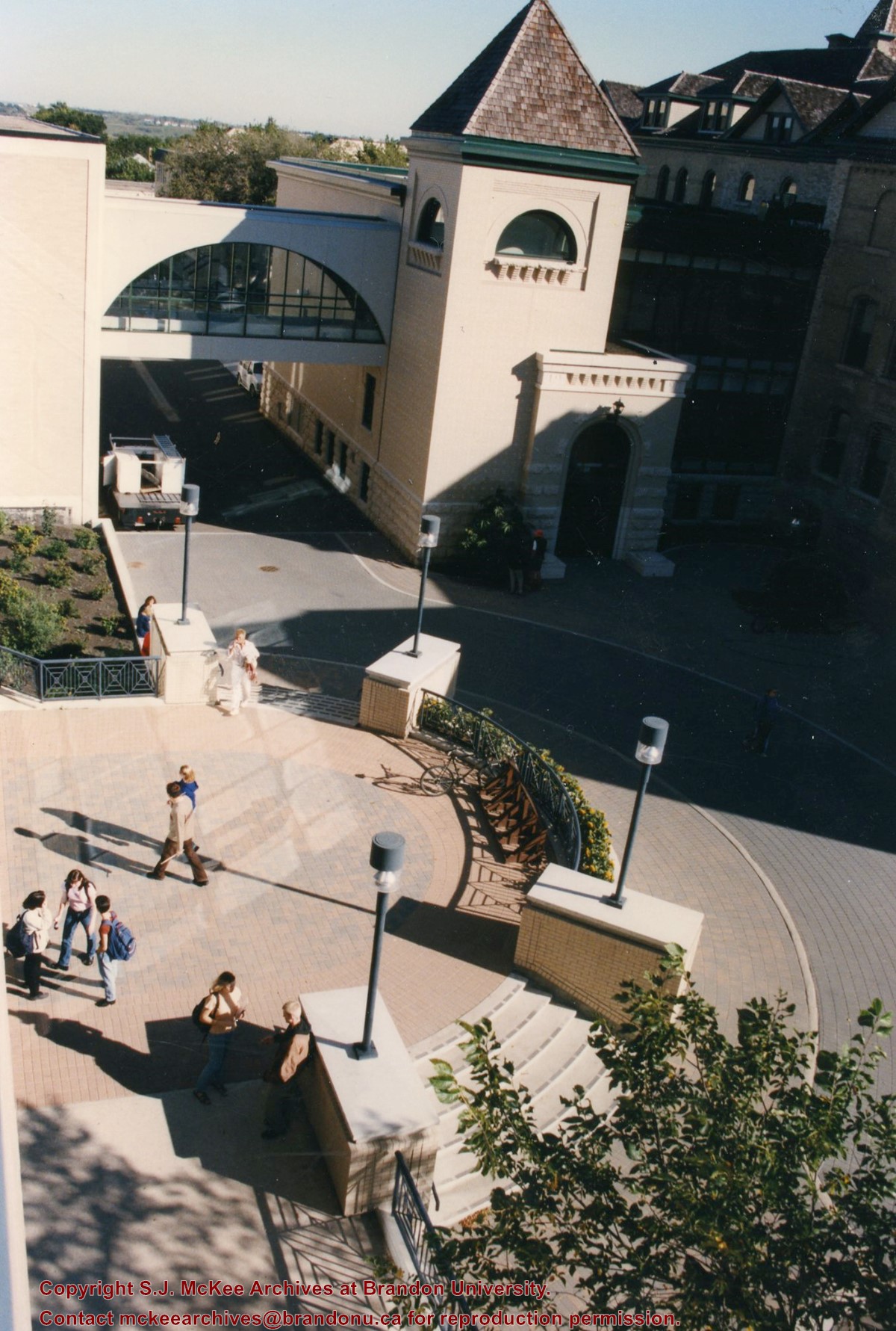
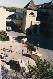
View is southwest from the corner of Clark Hall and the Clark Hall extension. Photograph shows students entering and exiting the George T. Richardson Centre and walking through the courtyard.
Images
Show Less

Brandon University campus

http://archives.brandonu.ca/en/permalink/descriptions8033
Part Of
Aerial views and campus photographs
Description Level
Item
GMD
graphic
Date Range
c. 1990s
Part Of
Aerial views and campus photographs
Description Level
Item
Series Number
2.1
Item Number
2.1.101
GMD
graphic
Date Range
c. 1990s
Physical Description
4" x 6" (colour)
Scope and Content
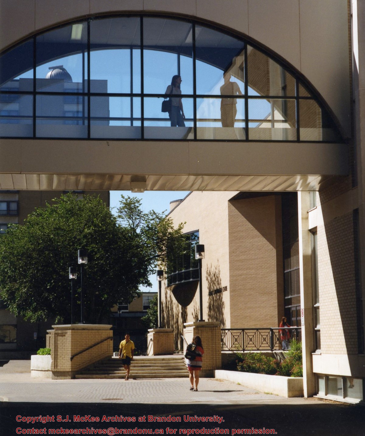
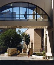
View is south from appromately the skywalk. Photograph shows the walkway that runs in front of the A.E. McKenzie Building south to the George T. Richardson Centre staircase and entrance. McMaster Hall in the background.
Images
Show Less

Brandon University campus

http://archives.brandonu.ca/en/permalink/descriptions8034
Part Of
Aerial views and campus photographs
Description Level
Item
GMD
graphic
Date Range
c. 2000
Part Of
Aerial views and campus photographs
Creator
Photograph: Sandy Black
Description Level
Item
Series Number
2.1
Item Number
2.1.102
GMD
graphic
Date Range
c. 2000
Physical Description
4" x 6" (colour)
Scope and Content
View is north northeast from the roof of the John E. Robbins Library in the George T. Richardson Centre. Photograph shows the entrance to the Richardson Building, part of the courtyard and the Clark Hall extension.
Images
Show Less

Brandon University campus

http://archives.brandonu.ca/en/permalink/descriptions8035
Part Of
Aerial views and campus photographs
Description Level
Item
GMD
graphic
Date Range
c. 2000
Part Of
Aerial views and campus photographs
Creator
Photographer: Sandy Black
Description Level
Item
Series Number
2.1
Item Number
2.1.103
GMD
graphic
Date Range
c. 2000
Physical Description
6" x 4" (colour)
Scope and Content
View is northeast from in front of the John E. Robbins Library in the George T. Richardson Centre. Photograph shows the entrance to the Richardson Building, most of the courtyard, Clark Hall and its extension.
Images
Show Less

Brandon University campus

http://archives.brandonu.ca/en/permalink/descriptions8036
Part Of
Aerial views and campus photographs
Description Level
Item
GMD
graphic
Date Range
c. 2000
Part Of
Aerial views and campus photographs
Creator
Photographer: Sandy Black
Description Level
Item
Series Number
2.1
Item Number
2.1.104
GMD
graphic
Date Range
c. 2000
Physical Description
6" x 4" (colour)
Scope and Content
View is northeast from the roof of the George T. Richardson Centre (John E. Robbins Library). Photograph shows the courtyard and the west side of the Brandon College building and Clark Hall, as well as the Clark Hall extension and part of the skywalk.
Images
Show Less

Brandon University campus

http://archives.brandonu.ca/en/permalink/descriptions8037
Part Of
Aerial views and campus photographs
Description Level
Item
GMD
graphic
Date Range
c. 2000
Part Of
Aerial views and campus photographs
Creator
Photographer: Sandy Black
Description Level
Item
Series Number
2.1
Item Number
2.1.105
GMD
graphic
Date Range
c. 2000
Physical Description
6" x 4" (colour)
Scope and Content
View is east southeast from the roof of the A.E. McKenzie Building. Photograph shows the courtyard and the west side of the Brandon College Building, as well as the Citizens' Science Building and the greenspace in between the two buildings.
Images
Show Less

Brandon University campus

http://archives.brandonu.ca/en/permalink/descriptions8038
Part Of
Aerial views and campus photographs
Description Level
Item
GMD
graphic
Date Range
c. 2000
Part Of
Aerial views and campus photographs
Creator
Photographer: Sandy Black
Description Level
Item
Series Number
2.1
Item Number
2.1.106
GMD
graphic
Date Range
c. 2000
Physical Description
4" x 6" (colour)
Scope and Content
View is from the front steps of the Education Building looking south down the east side of the Brandon College Building and Clark Hall to the Knowles Douglas Students' Union Centre and the John R. Brodie Science Centre in the background.
Images
Show Less

Brandon University campus

http://archives.brandonu.ca/en/permalink/descriptions8039
Part Of
Aerial views and campus photographs
Description Level
Item
GMD
graphic
Date Range
c. 2000
Part Of
Aerial views and campus photographs
Creator
Photographer: Sandy Black
Description Level
Item
Series Number
2.1
Item Number
2.1.107
GMD
graphic
Date Range
c. 2000
Physical Description
4" x 6" (colour)
Scope and Content
Photograph shows the Brandon College Building. It was taken from the sidewalk on 18th Street looking southwest across the front lawn.
Notes
Note on the back of the photograph reads "Please return photo to Sandy."
Images
Show Less

Brandon University campus

http://archives.brandonu.ca/en/permalink/descriptions8040
Part Of
Aerial views and campus photographs
Description Level
Item
GMD
graphic
Date Range
c. 2000
Part Of
Aerial views and campus photographs
Creator
Photographer: Sandy Black
Description Level
Item
Series Number
2.1
Item Number
2.1.108
GMD
graphic
Date Range
c. 2000
Physical Description
4" x 5" (colour)
Scope and Content
View is south. Photograph shows the skywalk and the steps leading to the entrance of the George T. Richardson Centre.
Images
Show Less

Brandon University campus

http://archives.brandonu.ca/en/permalink/descriptions8041
Part Of
Aerial views and campus photographs
Description Level
Item
GMD
graphic
Date Range
c. 1988
Part Of
Aerial views and campus photographs
Description Level
Item
Series Number
2.1
Item Number
2.1.110
GMD
graphic
Date Range
c. 1988
Physical Description
5" x 4" (colour)
Scope and Content
View is north northwest from the roof of McMaster Hall. Photograph shows part of the Citizens' Science Building, a number of H-Huts, the Brandon College Building, the greenspace, the J.R.C. Evans Lecture Theatre, the A.E. McKenzie Building, the Queen Elizabeth II Music Building and the Western Manitoba Centennial Auditorium. A number of residential blocks are also visible.
Images
Show Less

Brandon University campus

http://archives.brandonu.ca/en/permalink/descriptions8042
Part Of
Aerial views and campus photographs
Description Level
Item
GMD
graphic
Date Range
c. 1995
Part Of
Aerial views and campus photographs
Description Level
Item
Series Number
2.1
Item Number
2.1.111
GMD
graphic
Date Range
c. 1995
Physical Description
6" x 4" (b/w)
Scope and Content
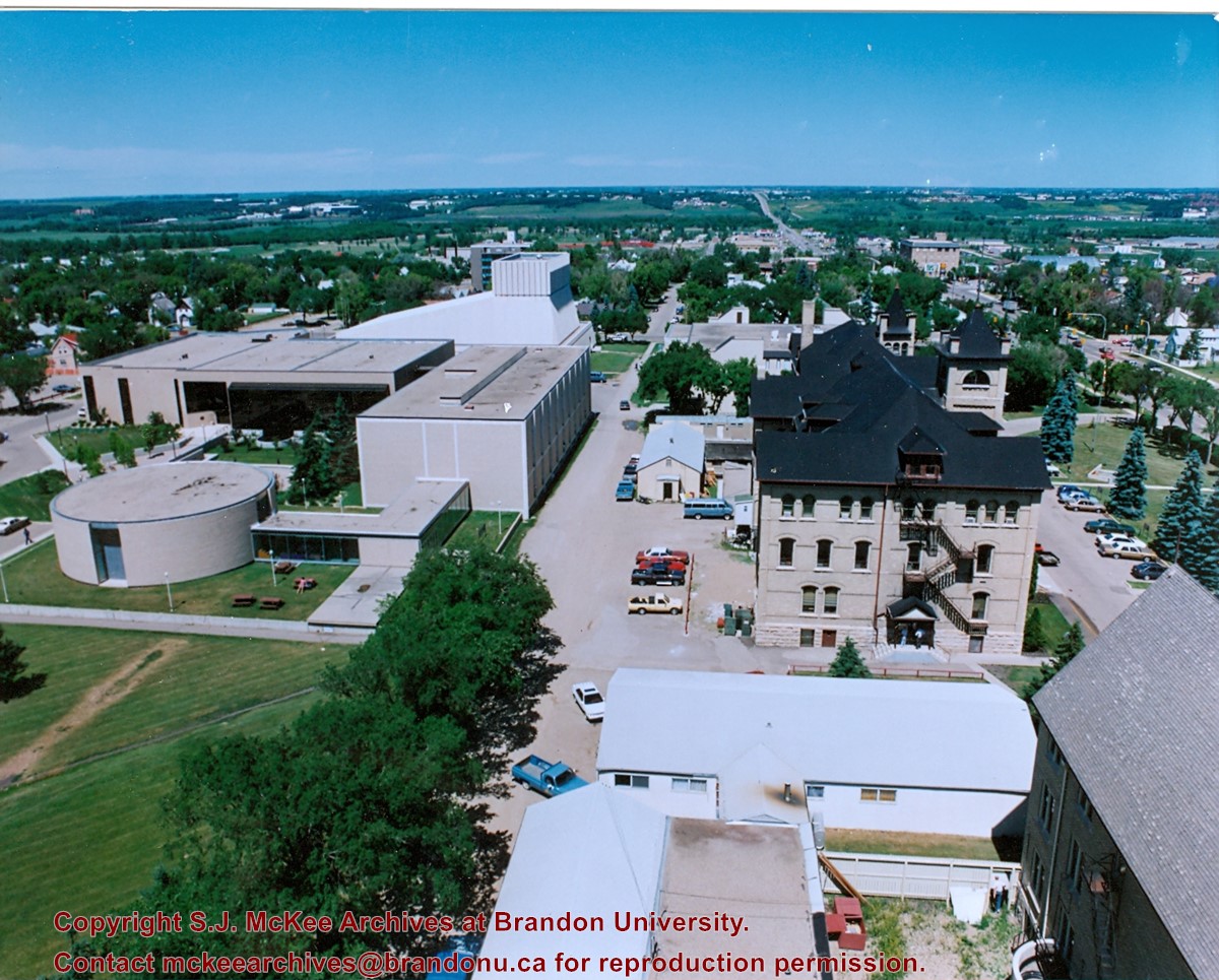
View is north northeast from the roof of McMaster Hall. Photograph shows a couple of H-Huts, the Brandon College Building, Clark Hall, the George T. Richardson Centre, the A.E. McKenzie Building, the original Music Building and the Western Manitoba Centennial Auditorium. A number of residential blocks are also visible.
Images
Show Less

Brandon University campus

http://archives.brandonu.ca/en/permalink/descriptions8043
Part Of
Aerial views and campus photographs
Description Level
Item
GMD
graphic
Date Range
c. 1995
Part Of
Aerial views and campus photographs
Description Level
Item
Series Number
2.1
Item Number
2.1.112
GMD
graphic
Date Range
c. 1995
Physical Description
4" x 6" (b/w)
Scope and Content
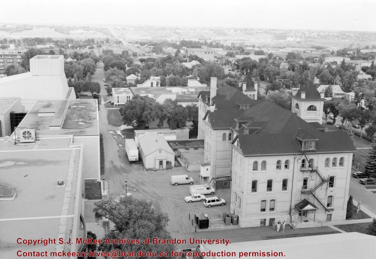
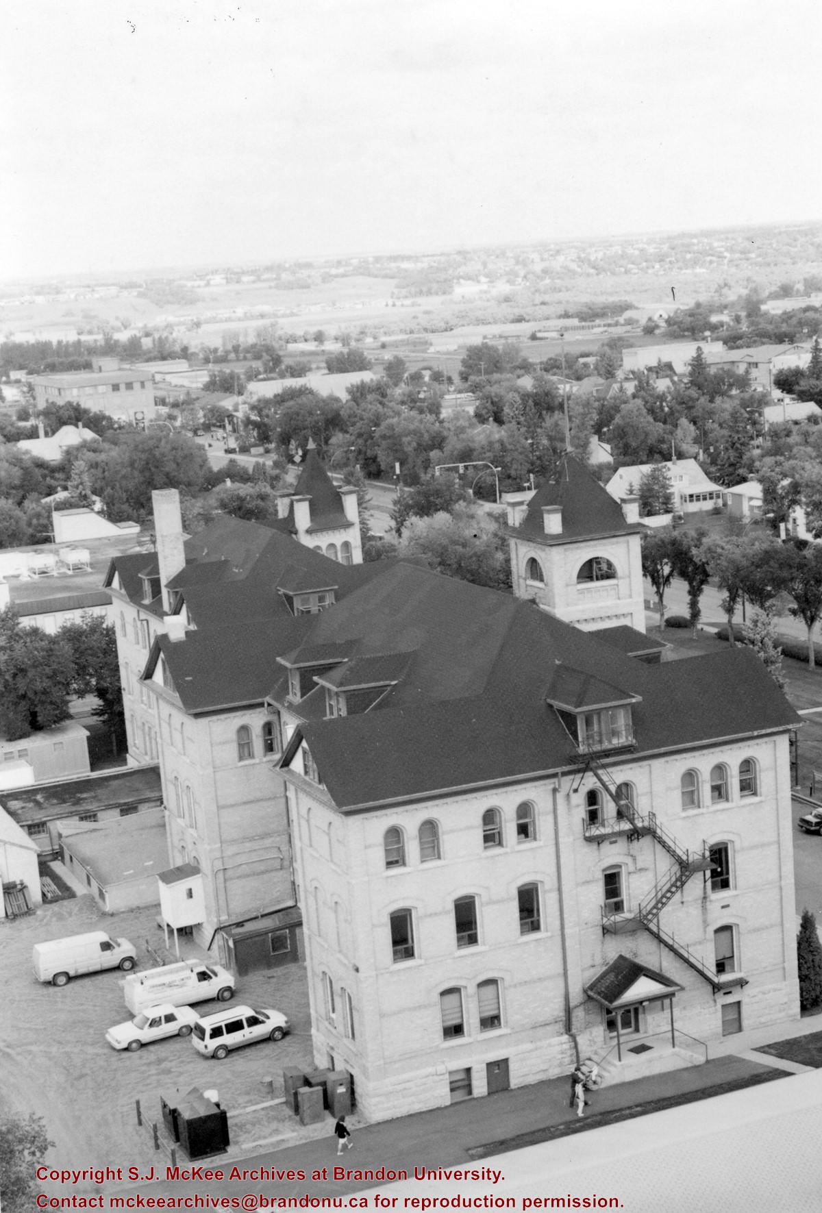
View is northeast from the roof of McMaster Hall. Photograph shows the Brandon College Building and Clark Hall, as well as the roof of the Education Building and portions of two H-Huts. A number of residential blocks are also visible.
Images
Show Less

Brandon University campus

http://archives.brandonu.ca/en/permalink/descriptions8044
Part Of
Aerial views and campus photographs
Description Level
Item
GMD
graphic
Date Range
c. 1972
Part Of
Aerial views and campus photographs
Description Level
Item
Series Number
2.1
Item Number
2.1.113
GMD
graphic
Date Range
c. 1972
Physical Description
5" x 3.5" (colour)
Scope and Content
View is northeast from the Dining Hall. Photograph shows the greenspace, the J.R.C. Evans Lecture Theatre, the A.E. McKenzie Building, the Brandon College Building and Clark Hall.
Images
Show Less

895 records – page 1 of 45.