Skip header and navigation

Revise Search

20 records – page 1 of 1.

City Hall and Prince Edward Hotel

http://archives.brandonu.ca/en/permalink/descriptions6426
Part Of
Alf Fowler collection
Description Level
Item
GMD
graphic
Date Range
ca. 1911
Accession Number
6-1999
Part Of
Alf Fowler collection
Creator
Davidson & Gowen
Description Level
Item
Item Number
6-1999.1
Accession Number
6-1999
GMD
graphic
Date Range
ca. 1911
Physical Description
9.5" x 7.25" (b/w)
Custodial History
See fonds level description of the Alf Fowler collection for custodial history.
Scope and Content
Photo was taken from the west side of 8th Street looking west. City Hall is in the foreground with the Prince Edward Hotel in the background.
Storage Range
RG 5 Western Manitoba Manuscript collection - photograph storage drawer
Images
Show Less
Part Of
Alf Fowler collection
Description Level
Item
GMD
graphic
Date Range
ca. 1911
Accession Number
6-1999
Part Of
Alf Fowler collection
Creator
Davidson & Gowen
Description Level
Item
Item Number
6-1999.5
Accession Number
6-1999
GMD
graphic
Date Range
ca. 1911
Physical Description
9.25" x 7.25" (b/w)
History / Biographical
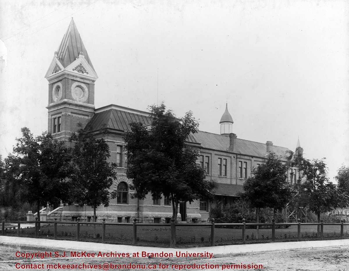
Brandon's City Hall and Opera House opened on New Year's Day 1892 with the Annual Fireman's Ball. The exterior of the building was designed by Brandon architect W.R. Marshall. At the south end was the Opera House, an auditorium formed by an internally exposed framework of delicate iron pillars and trusses. Demonlished in 1971, the limestone rubble of the foundations were turned into a sunken garden located in Princess Park.
Custodial History
See fonds level description of the Alf Fowler collection for custodial history.
Scope and Content
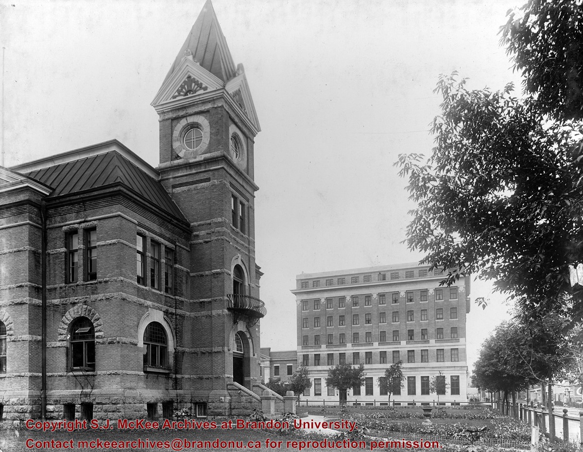
Photo was taken from the northwest corner of 9th Street and Princess Avenue and shows the west side of City Hall.
Notes
History/Bio information taken from the Assiniboine Historical Society's Brandon: An Architectural Walking Tour pamphlet (1982).
Location Copy
A 5" x 7" (b/w) reproduction of the photograph is located with the original.
Storage Range
RG 5 Western Manitoba Manuscript collection - photograph storage drawer
Images
Show Less

View from 1st street bridge looking west

http://archives.brandonu.ca/en/permalink/descriptions6438
Part Of
Alf Fowler collection
Description Level
Item
GMD
graphic
Date Range
ca. 1911
Accession Number
6-1999
Part Of
Alf Fowler collection
Creator
Davidson & Gowen
Description Level
Item
Item Number
6-1999.13
Accession Number
6-1999
GMD
graphic
Date Range
ca. 1911
Physical Description
9.5" x 7.5" (b/w)
Custodial History
See fonds level description of the Alf Fowler collection for custodial history.
Scope and Content
Photo shows Brandon from the 1st Street bridge, looking west. Massey-Harris Co. Limited and the Cockshutt Plow Company Limited are visible.
Storage Range
RG 5 Western Manitoba Manuscript collection - photograph storage drawer
Images
Show Less

View east-southeast from tower of Brandon Brewery

http://archives.brandonu.ca/en/permalink/descriptions6440
Part Of
Alf Fowler collection
Description Level
Item
GMD
graphic
Date Range
ca. 1911
Accession Number
6-1999
Part Of
Alf Fowler collection
Creator
Davidson & Gowen
Description Level
Item
Item Number
6-1999.15
Accession Number
6-1999
GMD
graphic
Date Range
ca. 1911
Physical Description
9.5" x 7.25" (b/w)
Custodial History
See fonds level description of the Alf Fowler collection for custodial history.
Scope and Content
Photo shows view east-southeast from tower of Brandon Brewery. Assiniboine Avenue and the west ramp of the Overhead bridge are visible.
Storage Range
RG 5 Western Manitoba Manuscript collection - photograph storage drawer
Images
Show Less

Bird's eye view - Experimental Farm

http://archives.brandonu.ca/en/permalink/descriptions6512
Part Of
Alf Fowler collection
Description Level
Item
GMD
graphic
Date Range
ca. 1911
Accession Number
6-1999
Part Of
Alf Fowler collection
Creator
Davidson & Gowen
Description Level
Item
Item Number
6-1999.88
Accession Number
6-1999
GMD
graphic
Date Range
ca. 1911
Physical Description
9.25" x 7.25" (b/w)
Custodial History
See fonds level description of the Alf Fowler collection for custodial history.
Scope and Content
Photo shows a bird's eye view from the Experimental Farm, looking southeast. Fields in the foreground, with Brandon in the background.
Storage Range
RG 5 Western Manitoba Manuscript collection - photograph storage drawer
Images
Show Less

Aerial view: Brandon University campus

http://archives.brandonu.ca/en/permalink/descriptions8046
Part Of
Aerial views and campus photographs
Description Level
Item
GMD
graphic
Date Range
late 1970s
Part Of
Aerial views and campus photographs
Description Level
Item
Series Number
2.1
Item Number
2.1.115
GMD
graphic
Date Range
late 1970s
Physical Description
5" x 3.5" (colour)
Scope and Content
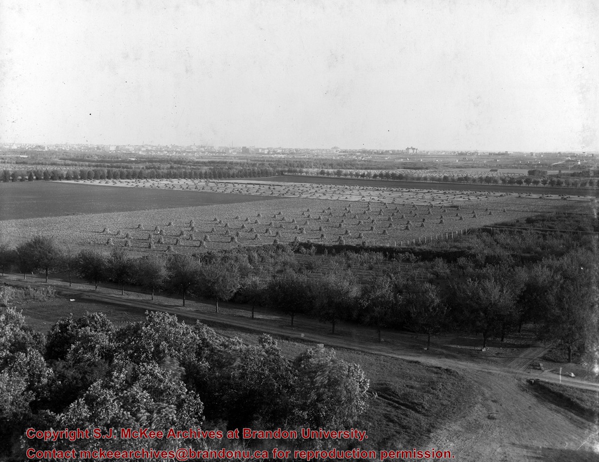
View is southwest from approximately Princess Avenue and 17th Street. Photograph shows the Brandon University campus in fall, as well as the southwest portion of the city.
Images
Show Less

Aerial view: Brandon University campus

http://archives.brandonu.ca/en/permalink/descriptions8047
Part Of
Aerial views and campus photographs
Description Level
Item
GMD
graphic
Date Range
1967-1969
Part Of
Aerial views and campus photographs
Description Level
Item
Series Number
2.1
Item Number
2.1.116
GMD
graphic
Date Range
1967-1969
Physical Description
5" x 4" (colour)
Scope and Content
View is south southwest from approximatley the east corner of 18th Street and Princess Avenue. Photograph shows the Brandon University campus, Kinsmen Stadium, Earl Oxford school and a number of residential blocks, particularly southwest of 18th Street.
Images
Show Less

Aerial view: Brandon University campus

http://archives.brandonu.ca/en/permalink/descriptions8048
Part Of
Aerial views and campus photographs
Description Level
Item
GMD
graphic
Date Range
1967-1969
Part Of
Aerial views and campus photographs
Description Level
Item
Series Number
2.1
Item Number
2.1.117
GMD
graphic
Date Range
1967-1969
Physical Description
5" x 4" (colour)
Scope and Content
View is southeast from approximatley 23rd Street and Rosser Avenue. Photograph shows the Brandon University campus, Kinsmen Stadium, Earl Oxford school, the Fair Grounds (including the Grandstand and Racetrack) and a number of residential blocks, particularly in the southeast part of the city.
Images
Show Less

Aerial view: Brandon University campus

http://archives.brandonu.ca/en/permalink/descriptions8049
Part Of
Aerial views and campus photographs
Description Level
Item
GMD
graphic
Date Range
1967-1969
Part Of
Aerial views and campus photographs
Description Level
Item
Series Number
2.1
Item Number
2.1.118
GMD
graphic
Date Range
1967-1969
Physical Description
5" x 3.5" (colour)
Scope and Content
View is west from 17th Street between Louise and Princess Avenues. Photograph shows the Brandon University Campus, Fleming School and Coronation Park, as well as a number of residential blocks.
Images
Show Less

Aerial view: Brandon University campus

http://archives.brandonu.ca/en/permalink/descriptions8050
Part Of
Aerial views and campus photographs
Description Level
Item
GMD
graphic
Date Range
c. 2000
Part Of
Aerial views and campus photographs
Creator
Photographer: Sandy Black
Description Level
Item
Series Number
2.1
Item Number
2.1.119
GMD
graphic
Date Range
c. 2000
Physical Description
8" x 5" (colour)
Scope and Content
View is southwest from the 200 block of 17th Street. Photograph shows the Brandon University campus, Kinsmen Stadium, Fleming School and a number of residential blocks.
Show Less

Aerial view: Brandon University campus

http://archives.brandonu.ca/en/permalink/descriptions8051
Part Of
Aerial views and campus photographs
Description Level
Item
GMD
graphic
Date Range
c. 1978
Part Of
Aerial views and campus photographs
Description Level
Item
Series Number
2.1
Item Number
2.1.120
GMD
graphic
Date Range
c. 1978
Physical Description
7" x 5" (colour)
Scope and Content
View is south southeast from approsimatley Rosser Avenue and 21st Street. Photograph shows the Brandon University campus, Kinsmen Stadium, Earl Oxford School, the Fair Grounds (including the Grand Stand and Race Track), and a number of residential blocks.
Images
Show Less

Aerial view: Brandon College campus

http://archives.brandonu.ca/en/permalink/descriptions8052
Part Of
Aerial views and campus photographs
Description Level
Item
GMD
graphic
Date Range
c. 1963
Part Of
Aerial views and campus photographs
Description Level
Item
Series Number
2.1
Item Number
2.1.121
GMD
graphic
Date Range
c. 1963
Physical Description
10" x 8" (b/w)
Scope and Content
View is southwest from the northeast corner of the Brandon College campus. Flora Cowan Hall is under construction.
Images
Show Less

Aerial view: Brandon University campus

http://archives.brandonu.ca/en/permalink/descriptions8053
Part Of
Aerial views and campus photographs
Description Level
Item
GMD
graphic
Date Range
c. 1967
Part Of
Aerial views and campus photographs
Description Level
Item
Series Number
2.1
Item Number
2.1.122
GMD
graphic
Date Range
c. 1967
Physical Description
10" x 8" (colour)
Scope and Content
View is south southwest from approximatley the southwest corner of 18th Street and Princess Avenue. Photograph shows the University campus, Kinsmen Stadium, Earl Oxford School and residential blocks.
Images
Show Less

Aerial view: Brandon University campus

http://archives.brandonu.ca/en/permalink/descriptions8054
Part Of
Aerial views and campus photographs
Description Level
Item
GMD
graphic
Date Range
c. 1967
Part Of
Aerial views and campus photographs
Description Level
Item
Series Number
2.1
Item Number
2.1.123
GMD
graphic
Date Range
c. 1967
Physical Description
10" x 8" (colour)
Scope and Content
View is west from 17th Street between Louise and Princess Avenues to approximalety 25th Street. Photograph shows the University campus, Fleming School, Coronation Park and residential blocks.
Images
Show Less

Aerial view: Brandon College campus

http://archives.brandonu.ca/en/permalink/descriptions8055
Part Of
Aerial views and campus photographs
Description Level
Item
GMD
graphic
Date Range
c. 1963
Part Of
Aerial views and campus photographs
Description Level
Item
Series Number
2.1
Item Number
2.1.124
GMD
graphic
Date Range
c. 1963
Physical Description
8" x 10" (b/w)
Physical Condition
A problem during development has obscured a portion of Kinsmen Stadium and the southeast corner of the campus.
Scope and Content
View is north from Victoria Avenue between 18th and 20th Streets to the railway tracks. Photograph shows Kinsmen Stadium, the College campus and a number of residential blocks.
Images
Show Less

Aerial view: Brandon College campus

http://archives.brandonu.ca/en/permalink/descriptions8056
Part Of
Aerial views and campus photographs
Description Level
Item
GMD
graphic
Date Range
c. 1963
Part Of
Aerial views and campus photographs
Description Level
Item
Series Number
2.1
Item Number
2.1.125
GMD
graphic
Date Range
c. 1963
Physical Description
10" x 8" (b/w)
Scope and Content
View is northeast from approximately the southwest corner of Victoria Avenue and 22nd Street to the Assiniboine River near 1st Street. Photograph shows the College campus, Kinsmen Stadium, residential blocks, downtown and the railway tracks.
Images
Show Less

Aerial view: Brandon University campus

http://archives.brandonu.ca/en/permalink/descriptions8057
Part Of
Aerial views and campus photographs
Description Level
Item
GMD
graphic
Date Range
c. 1967
Part Of
Aerial views and campus photographs
Description Level
Item
Series Number
2.1
Item Number
2.1.126
GMD
graphic
Date Range
c. 1967
Physical Description
10" x 8" (colour)
Scope and Content
View is southeast from north of the corner of Princess Avenue and 22nd Street to approximatley Brandon Avenue. Photograph shows the University campus, Kinsmen Stadium, Earl Oxford School, and residential blocks. Brandon Collegiate Institute (BCI) is visible in the upper left corner.
Images
Show Less

Aerial view: Brandon University campus

http://archives.brandonu.ca/en/permalink/descriptions8058
Part Of
Aerial views and campus photographs
Description Level
Item
GMD
graphic
Date Range
c. 1967
Part Of
Aerial views and campus photographs
Description Level
Item
Series Number
2.1
Item Number
2.1.127
GMD
graphic
Date Range
c. 1967
Physical Description
10" x 8" (b/w)
Scope and Content
View is west southwest from approximatley the northside of Princess Avenue just east of 18th Street. Photograph shows the University campus, part of Kinsmen Stadium and residential blocks.
Images
Show Less

Aerial view: Brandon University campus

http://archives.brandonu.ca/en/permalink/descriptions8059
Part Of
Aerial views and campus photographs
Description Level
Item
GMD
graphic
Date Range
c. 1967
Part Of
Aerial views and campus photographs
Description Level
Item
Series Number
2.1
Item Number
2.1.128
GMD
graphic
Date Range
c. 1967
Physical Description
10" x 8" (b/w)
Scope and Content
View is northwest from approximatley the southeast corner of 18th Street and Louise Avenue. Photograph shows the University campus and residential blocks.
Images
Show Less

Aerial view: Brandon University campus

http://archives.brandonu.ca/en/permalink/descriptions8060
Part Of
Aerial views and campus photographs
Description Level
Item
GMD
graphic
Date Range
c. 1978
Part Of
Aerial views and campus photographs
Description Level
Item
Series Number
2.1
Item Number
2.1.129
GMD
graphic
Date Range
c. 1978
Physical Description
10" x 8" (b/w)
Scope and Content
View is southwest from approximatley the corner of 17th Street and Princess Avenue to McDiarmid Drive. Photograph shows the Brandon University campus, Kinsmen Stadium, Fleming School, Coronation Park and residential blocks.
Images
Show Less

20 records – page 1 of 1.