Skip header and navigation

Revise Search

13 records – page 1 of 1.

Aerial view: Brandon College

http://archives.brandonu.ca/en/permalink/descriptions594
Part Of
Brandon University Photograph collection
Description Level
Item
GMD
graphic
Date Range
[fall 1964?]
Part Of
Brandon University Photograph collection
Description Level
Item
Series Number
2.1
Item Number
BUPC 2.1.2
GMD
graphic
Date Range
[fall 1964?]
Physical Description
5" x 4" (b/w)
Scope and Content
Brandon College looking south from 19th Street. Photograph was taken after Flora Cowan Hall was built but before construction of the Education Building.
Subject Access
aerial photographs
campus photographs
campus buildings
Brandon streets
Images
Show Less

Aerial view - Brandon College looking southwest

http://archives.brandonu.ca/en/permalink/descriptions601
Part Of
Brandon University Photograph collection
Description Level
Item
GMD
graphic
Date Range
[1963-1966]
Part Of
Brandon University Photograph collection
Description Level
Item
Series Number
2.1
Item Number
BUPC 2.1.8
GMD
graphic
Date Range
[1963-1966]
Physical Description
5" x 4" (b/w)
Scope and Content
Image shows the Brandon College campus from 17th Street looking southwest. The photo was taken after the completion of the original Music Building in 1963, but construction of the Education Building. Also visible are a number of properties on the 200 block of 18th Street and the 200 block of 20th Street.
Subject Access
aerial photographs
campus photographs
campus buildings
Brandon streets
Images
Show Less

Aerial view: Brandon College from 23rd Street

http://archives.brandonu.ca/en/permalink/descriptions602
Part Of
Brandon University Photograph collection
Description Level
Item
GMD
graphic
Date Range
[1963-1966]
Part Of
Brandon University Photograph collection
Description Level
Item
Series Number
2.1
Item Number
BUPC 2.1.9
GMD
graphic
Date Range
[1963-1966]
Physical Description
5" x 4" (b/w)
Scope and Content
Image is looking east northeast from approximately the 300 block of 23rd Street between Lorne and Louise Avenues. Photograph shows the Brandon College campus after the opening of the original Music Building in 1963, but before the construction of the Education Building in 1966. A number of house on the 300 blocks of 22nd and 21st Streets are visible in the foreground, with the A.E. McKenzie Seed Co., the Prince Edward Hotel and various grain elevators on the horizon.
Subject Access
aerial photographs
campus photographs
campus buildings
Brandon streets
Grain elevators
Images
Show Less

City Hall and Prince Edward Hotel

http://archives.brandonu.ca/en/permalink/descriptions6426
Part Of
Alf Fowler collection
Description Level
Item
GMD
graphic
Date Range
ca. 1911
Accession Number
6-1999
Part Of
Alf Fowler collection
Creator
Davidson & Gowen
Description Level
Item
Item Number
6-1999.1
Accession Number
6-1999
GMD
graphic
Date Range
ca. 1911
Physical Description
9.5" x 7.25" (b/w)
Custodial History
See fonds level description of the Alf Fowler collection for custodial history.
Scope and Content
Photo was taken from the west side of 8th Street looking west. City Hall is in the foreground with the Prince Edward Hotel in the background.
Storage Range
RG 5 Western Manitoba Manuscript collection - photograph storage drawer
Images
Show Less
Part Of
Alf Fowler collection
Description Level
Item
GMD
graphic
Date Range
ca. 1911
Accession Number
6-1999
Part Of
Alf Fowler collection
Creator
Davidson & Gowen
Description Level
Item
Item Number
6-1999.5
Accession Number
6-1999
GMD
graphic
Date Range
ca. 1911
Physical Description
9.25" x 7.25" (b/w)
History / Biographical
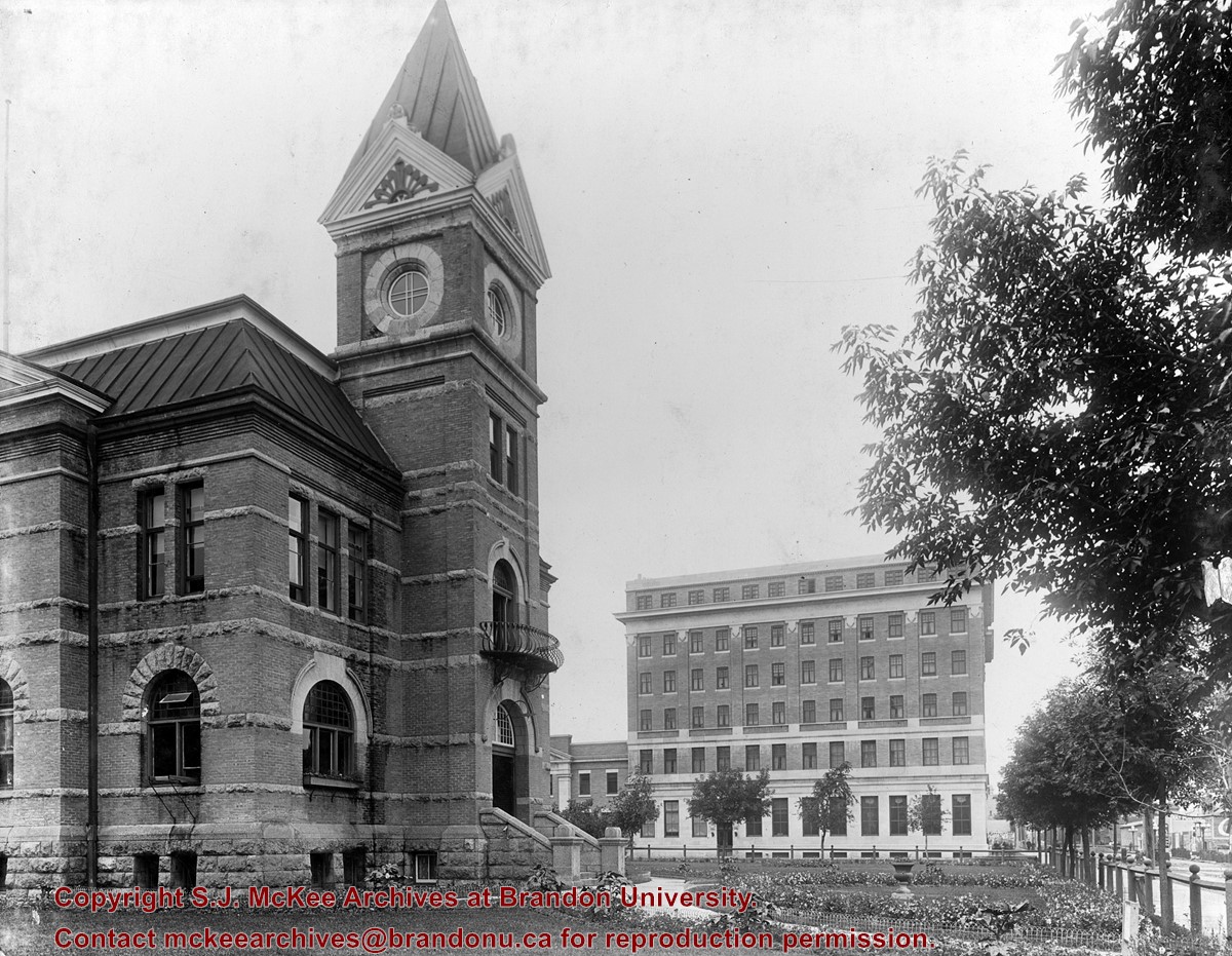
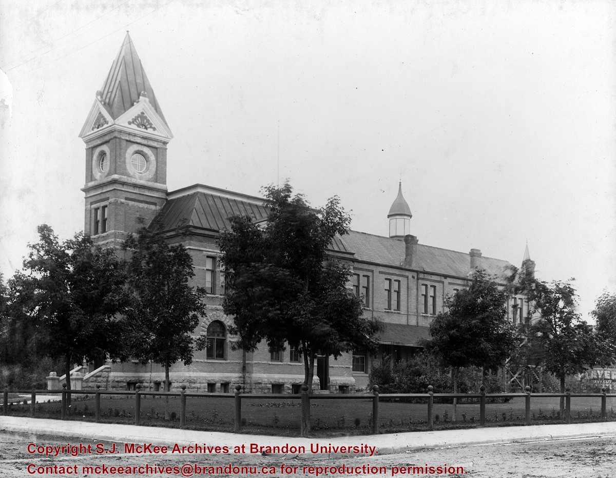
Brandon's City Hall and Opera House opened on New Year's Day 1892 with the Annual Fireman's Ball. The exterior of the building was designed by Brandon architect W.R. Marshall. At the south end was the Opera House, an auditorium formed by an internally exposed framework of delicate iron pillars and trusses. Demonlished in 1971, the limestone rubble of the foundations were turned into a sunken garden located in Princess Park.
Custodial History
See fonds level description of the Alf Fowler collection for custodial history.
Scope and Content
Photo was taken from the northwest corner of 9th Street and Princess Avenue and shows the west side of City Hall.
Notes
History/Bio information taken from the Assiniboine Historical Society's Brandon: An Architectural Walking Tour pamphlet (1982).
Location Copy
A 5" x 7" (b/w) reproduction of the photograph is located with the original.
Storage Range
RG 5 Western Manitoba Manuscript collection - photograph storage drawer
Images
Show Less

View from 1st street bridge looking west

http://archives.brandonu.ca/en/permalink/descriptions6438
Part Of
Alf Fowler collection
Description Level
Item
GMD
graphic
Date Range
ca. 1911
Accession Number
6-1999
Part Of
Alf Fowler collection
Creator
Davidson & Gowen
Description Level
Item
Item Number
6-1999.13
Accession Number
6-1999
GMD
graphic
Date Range
ca. 1911
Physical Description
9.5" x 7.5" (b/w)
Custodial History
See fonds level description of the Alf Fowler collection for custodial history.
Scope and Content
Photo shows Brandon from the 1st Street bridge, looking west. Massey-Harris Co. Limited and the Cockshutt Plow Company Limited are visible.
Storage Range
RG 5 Western Manitoba Manuscript collection - photograph storage drawer
Images
Show Less

View east-southeast from tower of Brandon Brewery

http://archives.brandonu.ca/en/permalink/descriptions6440
Part Of
Alf Fowler collection
Description Level
Item
GMD
graphic
Date Range
ca. 1911
Accession Number
6-1999
Part Of
Alf Fowler collection
Creator
Davidson & Gowen
Description Level
Item
Item Number
6-1999.15
Accession Number
6-1999
GMD
graphic
Date Range
ca. 1911
Physical Description
9.5" x 7.25" (b/w)
Custodial History
See fonds level description of the Alf Fowler collection for custodial history.
Scope and Content
Photo shows view east-southeast from tower of Brandon Brewery. Assiniboine Avenue and the west ramp of the Overhead bridge are visible.
Storage Range
RG 5 Western Manitoba Manuscript collection - photograph storage drawer
Images
Show Less

Bird's eye view - Experimental Farm

http://archives.brandonu.ca/en/permalink/descriptions6512
Part Of
Alf Fowler collection
Description Level
Item
GMD
graphic
Date Range
ca. 1911
Accession Number
6-1999
Part Of
Alf Fowler collection
Creator
Davidson & Gowen
Description Level
Item
Item Number
6-1999.88
Accession Number
6-1999
GMD
graphic
Date Range
ca. 1911
Physical Description
9.25" x 7.25" (b/w)
Custodial History
See fonds level description of the Alf Fowler collection for custodial history.
Scope and Content
Photo shows a bird's eye view from the Experimental Farm, looking southeast. Fields in the foreground, with Brandon in the background.
Storage Range
RG 5 Western Manitoba Manuscript collection - photograph storage drawer
Images
Show Less

Aerial view - Brandon University campus

http://archives.brandonu.ca/en/permalink/descriptions7989
Part Of
Brandon University Photograph collection
Description Level
Item
GMD
graphic
Date Range
c. 2000
Part Of
Brandon University Photograph collection
Creator
Photograph commissioned by Brandon University and taken by Yourview Aerial Scenics Ltd.
Description Level
Item
Series Number
2.1
Item Number
BUPC 2.1.55
GMD
graphic
Date Range
c. 2000
Physical Description
6" x 4" (colour)
Scope and Content
View is southwest from approximatley 16th Street between Princess and Rosser Avenues. Photograph shows the Brandon University campus, as well as surrounding residential blocks, including Flemming, J.R. Reid and Vincent Massey schools.
Subject Access
aerial photographs
campus photographs
campus buildings
Brandon streets
Images
Show Less

Aerial view - Brandon University campus

http://archives.brandonu.ca/en/permalink/descriptions7990
Part Of
Brandon University Photograph collection
Description Level
Item
GMD
graphic
Date Range
c. 2000
Part Of
Brandon University Photograph collection
Creator
Photograph commissioned by Brandon University and taken by Yourview Aerial Scenics Ltd.
Description Level
Item
Series Number
2.1
Item Number
BUPC 2.1.56
GMD
graphic
Date Range
c. 2000
Physical Description
6" x 4" (colour)
Scope and Content
View is west southwest from approximatley 16th Street between Princess and Lorne Avenues. Photograph shows the Brandon University campus, as well as surrounding residential blocks between 16th and 23rd Streets, Princess and Louise Avenues..
Subject Access
aerial photographs
campus photographs
campus buildings
Brandon streets
Images
Show Less

Aerial view - Brandon University campus

http://archives.brandonu.ca/en/permalink/descriptions7991
Part Of
Brandon University Photograph collection
Description Level
Item
GMD
graphic
Date Range
c. 2000
Part Of
Brandon University Photograph collection
Creator
Photograph commissioned by Brandon University and taken by Yourview Aerial Scenics Ltd.
Description Level
Item
Series Number
2.1
Item Number
BUPC 2.1.57
GMD
graphic
Date Range
c. 2000
Physical Description
6" x 4" (colour)
Scope and Content
View is west from approximatley 17th Street between Lorne and Louise Avenues. Photograph shows a portion of the Brandon University campus (excluding the Education Building and anything north of it), as well as surrounding residential blocks from approximatley 17th Street to 22nd Street.
Subject Access
aerial photographs
campus photographs
campus buildings
Brandon streets
Images
Show Less

Aerial view - Brandon University campus

http://archives.brandonu.ca/en/permalink/descriptions7992
Part Of
Brandon University Photograph collection
Description Level
Item
GMD
graphic
Date Range
c. 1990
Part Of
Brandon University Photograph collection
Description Level
Item
Series Number
2.1
Item Number
BUPC 2.1.58
GMD
graphic
Date Range
c. 1990
Physical Description
5" x 3.5" (colour)
Scope and Content
View is west northwest from approximatley 16th Street and Louise Avenue. Photograph shows the Brandon University campus, prior to the Library Extension, and a large portion of the city to the west of the campus.
Subject Access
aerial photographs
campus photographs
campus buildings
Brandon streets
Images
Show Less

Aerial view: Brandon University campus

http://archives.brandonu.ca/en/permalink/descriptions8064
Part Of
Brandon University Photograph collection
Description Level
Item
GMD
graphic
Date Range
[1972-1978]
Part Of
Brandon University Photograph collection
Description Level
Item
Series Number
2.1
Item Number
BUPC 2.1.133
GMD
graphic
Date Range
[1972-1978]
Physical Description
10" x 8" (b/w)
Scope and Content
View is southwest from approximatley 16th Street between Lorne Avenue and Princess Avenue. The view extends to approximately 26th Street. Photograph shows the Brandon University campus, Kinsmen Stadium, Fleming School, Coronation Park and residential blocks.
Images
Show Less

13 records – page 1 of 1.