Introduction
Information on archaeological materials in this locale first came to the attention of Dr. Nicholson through Doug Jackson, a local artifact collector from Souris. Doug had observed archaeological materials that included bone, ceramics and lithic material that had been exposed by municipal road building activity, northwest of Lauder Manitoba
Environment
The Makotchi-Ded Dontipi locale is located among stabilized sand dunes in the Lauder Sandhills in Southwestern Manitoba, northwest of the village of Lauder. The area is a mosaic of medium grass prairie and copses of aspen poplar and aspen-oak, together with intermittent sedge grass marshes and small ponds. These wetlands are bordered with balsam poplar, water birch, willows and red osier dogwood.
The well-drained upland forest also contains saskatoon, chokecherry, wild current, hazelnut bushes and occasional wild plums. Lowland areas have nannyberries and high-bush cranberry. Wild strawberries grow in lightly shaded areas along trail margins and in open patches in aspen forest.
History of Excavations
The Makotchi-Ded Dontipi locale is a virtual "island" of forest and marshlands in a vast expanse of mixed grass prairie. This archaeologically and environmentally rich area was given the Dakota name Makotchi-Ded Dontipi, meaning "the place where we live".
Summation
Prior to European settlement, the area was a rich environment for hunter-gatherer people. Archaeological investigations from 1992 to 2002 have revealed numerous sites within the locale. Some of these sites have been extensively excavated while others have been identified or tested.
Seven sites that have been identified in this locale range in age from the historic through protohistoric periods and extend into the middle precontact period. The major sites are the initial Middle Missouri Duthie site, the late precontact Jackson, Bradshaw sites and the protohistoric Twin Fawns, Schuddemat and Hollow B sites. The multi-component Vera site includes historic Métis, late precontact Vickers Focus, and middle precontact Besant, Pelican Lake, McKean Complex and Oxbow occupations. Over 230 units were excavated as well as numerous test pits and several extensive surveys.
Scope and Content
Scope and Content
The Series has been divided into seven sub-series, including (1) Duthie site (2) Jackson site (3) Twin Fawns site (4) Vera site (5) Schuddemat site (6) Bradshaw site (7) Hollow B site.
The Duthie site is the first site identified in the Makotchi-Ded Dontipi locale. It was reported to Dr. Bev Nicholson by Doug Jackson, a local collector who had observed archaeological materials that had been exposed during the construction of Maple Hill Road northwest of Lauder. The site is named after the landowner, Randy Duthie.
The initial inspection of the exposed materials indicated that the eastern half of the site had been severely impacted by raising a road grade using an elevating grader. However, an undetermined amount of the site remained to the west, flanked by a low sand dune. Testing and preliminary excavations were conducted in 1992-93. In 1994 a field school added to the excavated sample. The undisturbed portion of the site, west of Maple Hill Road was situated at the base of a low sand dune and had an aspen and willow forest cover. The water table was approximately one meter below surface at the time of excavation. A rising water table has since prevented further excavations.
Two dates on bone collagen were obtained during excavations. These were 880+/-80 B.P. (Beta 62705) and 970+/-40 B.P. cal. 1030 A.D. (TO 13366). These dates are consistent with an Initial Middle Missouri cultural assignment. The site occupation is identified by the distinctive ceramics found there. Ceramics at the Duthie Site are tool impressed with incising and lip modeling with fabric impressions on most vessels. Jill Taylor analysed the ceramics from the site for a Specialist thesis, Brandon University (1994) and a Masters of Arts degree from the University of Saskatchewan. (Taylor 1995).
Analysis of residue from Duthie site pottery by Matthew Boyd recovered corn (Zea mays) phytoliths and bean (Phaseolus sp.) starch grains indicating consumption of these domesticates at the Duthie site. (Boyd 2006)
The occupation of this site indicates a migration of people from the south who were well acquainted with horticultural farming. These people had previously migrated to South Dakota following river valleys into the central plains from the eastern woodlands during late Hopewell times. It appears that they later migrated well to the north into southern Manitoba but there is no evidence that they remained there for more than a single year.
Boyd, M., C. Surette and B.A. Nicholson. 2006 Archaeobotanical Evidence of Prehistoric Maize (Zea mays) Consumption at the Northern Edge of the Great Plains. Journal of Archaeological Science 33: 1129-1140.
Taylor, J. 1994 An analysis of the ceramics recovered during 1992 and 1993 at the Precontact Duthie Site (DiMe-16). Specialist thesis, Brandon University.
Scope and Content
The Series has been divided into seven sub-series, including (1) Duthie site (2) Jackson site (3) Twin Fawns site (4) Vera site (5) Schuddemat site (6) Bradshaw site (7) Hollow B site.
Field journals have been scanned in multi-page PDF files.
History / Biographical
The Crepeele site was excavated in 2003 as Crepeele 3. Standard archaeological methods were used to excavate the units. Excavation units were initially numbered as units 10, 11, 12 & 13. These numbers have been changed on the catalogue to XU 110 – 113, due to duplication in 2005. Corresponding documents have been changed to reflect the amended excavation unit numbers, however the field journals may contain the initial numbers.
Scope and Content
Record of daily observations at the site including: excavation methods, items recovered, features, local environment and weather.
File consists of a request for approval in principle and a request for final approval for financial assistance for special capital project to the Universities Grants Commission, correspondence, notes and a blueprint.
Storage Location
RG 6 Brandon University fonds
Series 2: Board of Governors
2.6 Board Projects
Box 1
The Brandon College Students series is an artificially created collection. It contains the private papers of former Brandon College students.
Scope and Content
The series has been divided into the following sub-series:
MG 2 2.1 Kathleen Emily Kenner
MG 2 2.2 Gerald R. Brown
MG 2 2.3 Saul L. Cohen
MG 2 2.4 Paul McKinnon
MG 2 2.5 Verda McDonald
MG 2 2.6 Frances Percival (nee Fraser)
MG 2 2.7 Raymond R. Bailey
MG 2 2.8 Harold Arthur Kinniburgh
MG 2 2.9 Barbara Cooper
MG 2 2.10 Class of 1953
MG 2 2.11 Elizabeth Kovach
MG 2 2.12 Carole Paintin-Dence
MG 2 2.13 Edward Lloyd Bowler
MG 2 2.14 Rev. Einar Egilsson
MG 2 2.15 George Thorman
MG 2 2.16 Robert Dudley Howland
MG 2 2.17 Charles H. Koester
MG 2 2.18 Robert Harvey
MG 2 2.19 Lawrence Skeoch
MG 2 2.20 Edith Laycock
MG 2 2.21 Marion Stone
MG 2 2.22 Margaret Doran Roberts
MG 2 2.23 Georgina (Hill) Matiation
MG 2 2.24 Class of 1950
MG 2 2.25 Donald Freeman
MG 2 2.26 William Archibald Branton
MG 2 2.27 Adelene Monica Bailey
MG 2 2.28 Lois and Gordon Daly
MG 2 2.29 Marionne Scott
MG 2 2.30 Christine Coltart
MG 2 2.31 Bertha Leith (nee Clark)
MG 2 2.32 Margaret Hawley Speers
MG 2 2.33 Ruth and Archie MacLachlan
MG 2 2.34 Fran Sallows
MG 2 2.35 Clare Coburn
MG 2 2.36 Gordon Lindsay
9.46 m textual records; 1919 photographs & graphics
History / Biographical
Brandon, Manitoba was incorporated as a city in 1881. In 1882, led by Charles Whitehead and a small Board of Directors that included J.W. Vantassel, Charles Pilling, George Halse, J.E. Smith, William Johnson, R.T. Evans, and Thomas Lockhart, it was decided to hold an agricultural exhibition. These men were all involved in the farm business in one way or another, and they wanted an opportunity to help residents realize the agricultural potential of the region. In October of that year, the fledgling community held its first agricultural exhibition . The fair was held in downtown Brandon at what was known as “Market Square.” Market Square was two acres of land located on Princess Avenue between Eighth and Ninth Streets. Due to poor weather, and the fact that not many people were ready to show animals and grain, there was a relatively small turnout. The following year was much improved. There were 730 entries into the exhibition. By 1884, the Board of Directors of the Brandon Agricultural Society, which was in charge of the exhibition, realized that they were in poor financial shape, to the point of being personally out of pocket. It was realized that October was not the best time for farmers to be leaving their farms to go to an exhibition. In 1888, it was decided to move the exhibition to the summer time, when it was much easier for people to attend.
The first Brandon Summer Fair was held in July 1889, and it was a resounding success. The Board of Directors had added many items of interest to appeal to the entire public, not just agricultural people. In 1892, the Western Agricultural and Arts Association (WAAA) was formally established to take over duties from the Brandon Agricultural Society. However, it was not until 1897 that the WAAA held its first meeting. There is no explanation as to why there is a five year gap between the formation and the first meeting of this organization. 1897 was the turning point of the Brandon Exhibition. The fair was now firmly established in Brandon, and the Board of Directors was instrumental in ensuring that it remained so. This was done by petitioning to both the municipal and provincial governments for grant money. As well, the Board booked midway and grandstand acts that would bring the city dwellers to the agricultural exhibition.
There were also early attempts at holding an agricultural exhibition in the winter. The first such attempt was in 1884. There was also a Spring Stallion show held in 1891. By 1904, however, a petition by J.D. McGregor had gone out to formally establish a winter exhibition. This effort also failed, but by 1906, it was decided by businessmen, politicians, and farm representatives in Brandon, including McGregor, to organize a winter fair. Rather than seeing this new fair as competition, the Board of Directors of the summer fair felt that it would complement their exhibition. The new fair would remain primarily agricultural. The first winter fair was held in 1906. While the two fairs were not amalgamated, they did share the same secretary-manager. The secretary-manager was responsible for the day to day management of the fair, as well as keeping track of meetings and decisions reached by the various fair boards and committees. In 1907, the Brandon Winter Fair and Livestock Association (BWFLA) was formed to act primarily as a land-holding joint stock company. The following year the Provincial Winter Fair and Fat Stock Association (PWFFSA), an entirely separate organization from the BWFLA, was formed to manage the activities of the winter fair. The PWFFSA name was soon changed to the Manitoba Winter Fair and Fat Stock Association (MWFFSA).
By 1906, Brandon could boast two full size exhibitions, one in the summer and one in the late winter, both of which were considered to be premiere events. In 1908, the Brandon summer fair was renamed the Inter-Provincial Exhibition, and in 1912 it held it’s first Traveller’s Day, an event which would soon become an important addition to the fair and is still in existence today. It is thought that the name “Traveller’s Day” came from the fact that it was held on a Saturday, a day when many people could travel to Brandon for the exhibition.
In 1913, Brandon was bestowed with the honour of hosting the Dominion Exhibition. This was a national exhibition sponsored by the federal government. It was held in a different city every year. There were several cities vying for the 1913 Dominion Exhibition, but it was Brandon that impressed the sponsors the most. With the government funds received for this honour, the Board of Directors supervised the building of a new grandstand, display buildings, and racetrack, as well as the general expansion and improvements to the fairgrounds.
In the spring of 1912, it was decided by the Board of Directors of the winter fair that the facilities they were currently housed in were inadequate for their needs. The mayor and city clerk of Brandon went to the provincial legislature in order to request that there be an amendment added to the Brandon city charter. This amendment would allow the city to guarantee bonds issued by the winter fair board to help pay for the construction of a new facility. This request was granted, and a $70 000 addition was built next to the original winter fair building. The new building was opened in 1913.
Throughout the First World War, both the winter fair and Provincial Exhibition buildings were used for the war effort. There was one distinct difference however. The summer fair Board was able to negotiate a deal with the army that enabled it to reclaim the fair buildings during fair week. The winter fair, however, had to give up the idea of holding fairs in 1915 and 1916. It was not until 1917, that the winter fair was able to resume.
During this time, due to the financial problems that had beset the winter fair, the two exhibitions considered amalgamation. The Board of Directors of the winter fair felt that because they were the smaller of the two fairs, their interests would be swallowed up by the summer fair. The winter fair withdrew from the negotiations to amalgamate. With this rather sudden turn of events, the Board of Directors of the summer fair petitioned the government to be allowed to incorporate. This was granted, and in 1920, the WAAA was incorporated as the Provincial Exhibition of Manitoba. From 1920, the summer fair was officially known as the Provincial Exhibition of Manitoba. This was the first time that the summer fair was incorporated, and received the “status and financial assistance” that came with incorporation.
More problems beset the winter fair in the 1920s. In 1920, a fire burned down the winter fair pavilion, located at the south end of the winter fair buildings, and caused the Board to cancel the 1921 winter fair. It was not until 1922, that a new building was completed. By 1929, both fairs were well regarded throughout Canada. In 1929, a decade long Depression hit the west. While many fairs closed during this time, Brandon struggled to keep its open. The Directors of both fairs felt that the agricultural shows “encouraged excellence at a time when faith and enthusiasm were at a low ebb.” The summer fair proved to be quite successful during the Depression, likely as a result of the few moments one was able to forget one’s troubles while there. The winter fair was not quite as successful, although both fairs received government grants and work relief projects. There was little new entertainment in these exhibitions.
There were changes about to manifest themselves at the summer fair, however. While the winter fair had representatives from various associations on its Board of Directors, the summer fair Board of Directors was a small close-knit group of men. Citizens saw entry into this elite group as elusive and difficult. To ward off the possibility of the Board becoming a “self-sustaining clique,” that only chose Directors from within, it was decided by several citizens to try and elect some new blood into the fair Board. In 1933, there was a general election for the Board. Instead of the usual men shuffling positions, there were forty-four nominations for the twenty positions. When the voting was all over, seven new men sat on the Board. Despite some inner rumblings, especially on the summer fair Board over the next few years, both exhibitions survived the Depression.
During the Second World War the fairs once again were forced to operate under adversity. Once again, the buildings were requisitioned for the army, although they were released during fair week. The summer fair was forced to make several concessions, and the winter fair was relocated to the summer fair grounds for the duration.
The winter fair did not survive the Second World War intact. Due to financial reasons, in December of 1945, the Board of Directors turned the winter fair buildings over to the City of Brandon. By 1946, the BWFLA, which was the joint-stock land holding company, had ceased operations because the city now controlled the winter fair land and buildings.
The next fifteen years would be a time of rebuilding for both of Brandon’s exhibitions. Children especially were more active participants in the agricultural exhibitions. The summer fair continued to diversify and look for new ways of entertaining the public at large. The winter fair remained primarily agricultural. By the end of the 1950s the winter fair, which was used to struggling, was now both successful and stable; and the summer fair, a perennial success, was starting to fade.
By 1969, both the winter and summer fair Boards had realized that amalgamation was the best possible decision, both practically and financially, for the future of the two fairs. On 29 October, 1969, the two exhibitions amalgamated to become the Manitoba Exhibition Association. The reconstituted Provincial Exhibition of Manitoba was now responsible for both the winter and summer fairs. A new building was erected on the summer fair grounds to house both of the exhibitions. On 2 April 1973, the Keystone Centre was officially opened at the winter fair, although it had been in use since October of the preceding year.
In 1970, Manitoba’s Centennial, it was decided that an organization in Manitoba would receive the title of “Royal,” as a way to celebrate the centennial. Although many organizations applied for the honour, it was the Brandon winter fair that received the accolades. The winter fair was bestowed with the title “Royal”, and became known as the Royal Manitoba Winter Fair.
In 1975, a third exhibition was added, this time a purely agricultural fall show known as the Agricultural Exhibition, or AgEx. This fair was partly organized on behalf of the cattle growers, who found that the summer and winter fairs did not give them adequate time and space to properly show their cattle. The return to a fall show, which had not existed since 1888, would be the return to a purely agricultural exhibition. This show was to be primarily a show and sale event. On 3 November 1975, the first AgEx was opened to resounding success.
The Provincial Exhibition of Manitoba, the Royal Manitoba Winter Fair and AgEx are all still in existence in Brandon. They are regarded as three of the most important events to take place annually in the city.
Custodial History
These files were housed with the Manitoba Exhibition Association until c1986 when they were transferred to the S.J. McKee Archives at Brandon University.
Scope and Content
The fonds consists of textual records and photographs comprised of the records from the three annual exhibitions that are held in Brandon, Manitoba: the Provincial Exhibition of Manitoba, the Royal Manitoba Winter Fair, and the Agricultural Exhibition (Ag-Ex). The textual records include prize lists, programs, minutes, financial, administrative files, original results, scrapbooks, tickets, news releases, contracts, by laws, documents as well as a miscellaneous section. There are approximately 1846 photographs that include scenes from these three exhibitions. These records provide a unique perspective on the development of agriculture and rural life in southwestern Manitoba. Fairs such as these have been and remain prime media of farm improvement, technological and scientific advancement in rural Canada, and the promoters of country living. These fairs also reflected the long tradition inherited from Britain and Europe of country fairs as centers of entertainment, social interchange and diversion. These records are a principal source of information about the most broadly based vocational, entertainment and social events held on an annual basis in southwestern Manitoba over the last century. The records are vital to academic research on agriculture or fairs, individual biography, or community history.
Notes
The RG 2 Provincial Exhibition of Manitoba Association finding aid was created by Karyn (Riedel) Taylor with the exception of Series 9 and the accompanying database, which were created by Donica Belisle. This finding aid was created in August 1999.
Researchers are responsible for observing Canadian copyright restrictions.
Finding Aid
Available
Storage Location
RG 2 Provincial Exhibition of Manitoba Association fonds
Storage Range
RG 2 Provincial Exhibition of Manitoba Association fonds
Related Material
Additional records regarding the Provincial Exhibition of Manitoba, the Royal Manitoba Winter Fair, and AgEx are housed at the Provincial Exhibition of Manitoba Association offices. To gain access to these records, it is necessary to contact the general manager of the Provincial Exhibition of Manitoba Association.
Arrangement
The fonds is divided into sous-fonds by exhibition. There is a Provincial Exhibition sous-fonds, a Royal Manitoba Winter Fair sous-fonds, an Ag-Ex sous-fonds, and a Miscellaneous sous-fonds that holds information that could not be easily broken down into one exhibition. The arrangement is as follows:
RG 2 Provincial Exhibition Association of Manitoba fonds
RG2SF1 Provincial Exhibition of Manitoba
1.1 Documents
1.2 Minutes
1.3 Financial Records
1.4 Administrative Files
1.5 Prize Lists and Programs
1.6 News Releases
1.7 Original Results
1.8 Tickets
1.9 Photographs
1.10 Scrapbooks
1.11 Miscellaneous
RG2SF2 Royal Manitoba Winter Fair
2.1 Documents
2.2 Minutes
2.3 Financial Records
2.4 Administrative Files
2.5 Prize Lists and Programs
2.6 News Releases
2.7 Original Results
2.8 Tickets
2.9 Photographs
2.10 Scrapbooks
2.11 Miscellaneous
RG2SF3 AgEx
3.4 Administrative Files
3.5 Prize Lists and Programs
3.6 News Releases
3.7 Original Results
3.9 Photographs
RG2SF4 Miscellaneous
4.1 Documents
4.2 Minutes
4.3 Financial Records
4.4 Administrative Files
4.9 Photographs
4.10 Scrapbooks
4.11 Miscellaneous
The Board of Governors of Brandon University is a body established by the Brandon University Act (1998), a statute of the Province of Manitoba. The Act vests in the Board the authority for governing Brandon University. The members of the Board of Governors, as trustees, hold the University in trust for the people of the Province of Manitoba. Responsibilities for maintaining this trust include: selection of a president, monitoring his/her performance, providing guidance to the University via its policies, and often delegating authority to the administration.
The Board of Governors is a collective representing the entire community (both internal and external of the University). As a collective, the Board of Governors is responsible for ensuring the financial stability of the institution and for seeing that the overall plans of the institution are consistent with the institution’s philosophy, goals, and financial resources.
Scope and Content
Fonds consists of records generated and collected by the Brandon University Board of Governors in the course of perfoming its functions. The fonds is divided into six sub-series, incuding: (1) Documents; (2) Board Executive; (3) General Board agendas, minutes and packages; (4) Correspondence and subject files; (5) Board of Governors' committees; and (6) Board projects.
Notes
The information in the History/Bio field was taken from the Brandon University webpage (http://www.brandonu.ca/Administration/Governors/) on December 2, 2005.
Access Restriction
All files in the series are restricted. Researchers are required to contact the Executive Secretary to the Board of Governors to obtain written permission to access the records. Contact:
204-727-9714
board@brandonu.ca
Field journals have been scanned in multi-page PDF files. Artifact catalogues are PDF files in spreadsheet format. Photographs are in jpeg format.
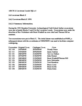
History / Biographical
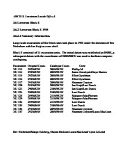
Excavations took place in block E in 1987 and 1988 with 21 units opened. Ten further units were excavated in 1991 as part of the Brandon University Archaeological Field School, directed by Dr. Nicholson with Brett Waddell as crew chief and Theresa Hill as field assistant.
In 1991 a hearth was identified in Block E as well as a cluster of spoil dirt piles believed to represent material from a pit feature identified in the 1988 excavations. The pit feature is believed to be related to the recovery of clay that may have been used to build ceramic vessels.
Stratigraphic evidence of distinct activity areas at successive depths and radiocarbon dates indicate at least three occupations (380 BP, 700 BP and 860 B P). Three identified activity clusters occur stratigraphically, supporting these dated occupations.
Large numbers of lithics were recovered, forming an assemblage dominated by SRC and KRF with lesser amounts of porcellanite and quartzite. The upper occupation contained some Tongue River Silicified Sediment (TRSS). Eight Prairie Side-Notched points were recovered as well as a lunate biface and an end scraper. Fragments from a grey soapstone tube were also recovered.
Scope and Content
Sub-sub-sub series contains: Summary information of field methology, number and co-ordinates of excavations, personnel and their staff position; Field journals are daily records of recoveries, features and activities at the site; Site records include excavation level and unit summaries, feature sheets, profiles; sample records and maps; Artifact catalogues are lists and identifications of all artifacts recovered; Photographs are of excavation units, features, the landscape and personnel.
Field journals have been scanned in multi-page PDF files. Artifact catalogues are PDF files in spreadsheet format. Photographs are in jpeg format.
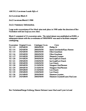
History / Biographical
Large scale excavations of two block sites took place in 1988 under the direction of Bev Nicholson with Brett Waddell as crew chief and Theresa Hill as assistant. Block E consisted of 10 additional excavation units.
Scope and Content
Sub-sub-sub series contains: Summary information of field methology, number and co-ordinates of excavations, personnel and their staff position.
Field journals have been scanned in multi-page PDF files. Artifact catalogues are PDF files in spreadsheet format. Photographs are in jpeg format.
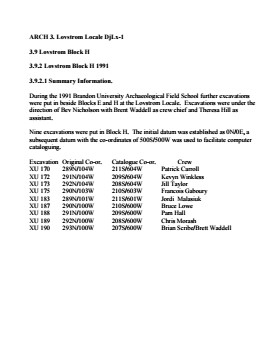
History / Biographical
Based on the recoveries at the Block H in 1988, further excavations took place in 1991. Nine excavation units were opened next to the previous excavations. Another 250 ceramic sherds were recovered in 1991. Nine vessels have been identified based on rim sherds. Vickers Focus and Woodland vessels have been identified and two vessels similar to Scattered Village Complex were recovered.
The lithic material assemblage is intermediate primarily KRF followed by local cherts. Two features, a hearth and a curvilinear arrangement of rock were recovered during the 1991 excavations.
The high numbers of ceramic fragments suggests a habitation area, rather than hunting or butchering behavior. However, the separation of occupations at the site is difficult to establish and there may be different uses of the site by successive occupations.
Scope and Content
Sub-sub-sub series contains: Summary information of field methology, number and co-ordinates of excavations, personnel and their staff position; Field journals are daily records of recoveries, features and activities at the site; Site records include excavation level and unit summaries, feature sheets, profiles; sample records and maps; Artifact catalogues are lists and identifications of all artifacts recovered; Photographs are of excavation units, features, the landscape and personnel.
Field journals have been scanned in multi-page PDF files. Artifact catalogues are PDF files in spreadsheet format. Photographs are in jpeg format.
History / Biographical
Large scale excavations of two block sites took place in 1988 under the direction of Bev Nicholson with Brett Waddell as crew chief and Theresa Hill as assistant. Block H consisted of nine additional excavation units.
Scope and Content
Sub-sub-sub series contains: Summary information of field methology, number and co-ordinates of excavations, personnel and their staff position.
Field journals have been scanned in multi-page PDF files. Artifact catalogues are PDF files in spreadsheet format. Photographs are in jpeg format.
History / Biographical
Directed by Dr. Nicholson and with Ian Kuijt as crew chief, fourteen additional units were excavated in Block E in 1988. Stratigraphic evidence of distinct activity areas at successive depths and radiocarbon dates indicate at least three occupations (380 BP, 700 BP and 860 B P).
Three identified activity clusters occur stratigraphically, supporting these dated occupations. A clear distinction between Blackduck and Vickers Focus ceramics is evident in this Block. Sixteen small side-notched and un-notched points were recovered in this excavation series as well as numerous unifacial scrapers. Fragments from a grey soapstone tube were also recovered.
Scope and Content
Sub-sub-sub series contains: Summary information of field methology, number and co-ordinates of excavations, personnel and their staff position; Field journals are daily records of recoveries, features and activities at the site; Site records include excavation level and unit summaries, feature sheets, profiles; sample records and maps; Artifact catalogues are lists and identifications of all artifacts recovered; Photographs are of excavation units, features, the landscape and personnel.
Field journals have been scanned in multi-page PDF files. Artifact catalogues are PDF files in spreadsheet format. Photographs are in jpeg format.
History / Biographical
Large scale excavations of four block sites took place in 1988 under the direction of Bev Nicholson with Ian Kuijt as crew chief. Block E consisted of 14 additional excavation units.
Scope and Content
Sub-sub-sub series contains: Summary information of field methology, number and co-ordinates of excavations, personnel and their staff position.
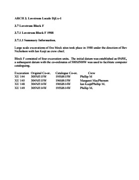
In 1988 four 1m2 units were excavated in this Block F. The forest cover is identical to that of Block E, with an open oak forest with a light understory of saskatoon, hazelnut, poison ivy and sarsaparilla.
Underneath the litter mat (Ah) is a shallow, 15-20 cm “A” horizon of dark grey/brown silty loam with a high representation of pebble size clasts. The glacial clays, encountered at 20 cm below surface, consist of a matrix of light tan sandy clays containing rounded pebble to cobble size rocks.
The recoveries from this block consisted of a few ceramics, including Vickers Focus rim sherds, four lithic tools and a number of small bison bone fragments. There was no discernible cultural stratigraphy in the four 1m2 units and the limited deposits of bone, ceramics and lithics were dispersed randomly throughout the 25 cm of cultural matrix. The lithic materials frequencies were similar to those in Block E with local cherts and KRF being the most abundant categories. A small amount of fire-cracked rock and a few large identifiable bison bones were recovered – all distributed randomly with little evidence for any pattern of clustering.
No RC dates.
Scope and Content
Sub-sub-sub series contains: Summary information of field methology, number and co-ordinates of excavations, personnel and their staff position; Field journals are daily records of recoveries, features and activities at the site; Site records include excavation level and unit summaries, feature sheets, profiles; sample records and maps; Artifact catalogues are lists and identifications of all artifacts recovered; Photographs are of excavation units, features, the landscape and personnel.
Field journals have been scanned in multi-page PDF files. Artifact catalogues are PDF files in spreadsheet format. Photographs are in jpeg format.
History / Biographical
Large scale excavations of four block sites took place in 1988 under the direction of Bev Nicholson with Ian Kuijt as crew chief. Block F consisted of 4 excavation units.
Scope and Content
Sub-sub-sub series contains: Summary information of field methology, number and co-ordinates of excavations, personnel and their staff position.
In 1988 four units were excavated in Block G. The vegetation is similar to other areas in the locale with an open oak forest with a light understory of saskatoon, hazelnut, poison ivy and sarsaparilla.
Excavations recovered artifacts between 0 cm – 15 cm b.s. The cultural deposits are very shallow and it is quite possible that what appears to be a single occupation may in fact represent multiple occupation compressed deposits as a result of deflation or the lack of sedimentation in this raised area. This latter view is supported by the ceramics which appear to be a mixture of Blackduck and Vickers Focus wares.
The frequency and distribution of cultural material from block G contrasts with that of other sites in the locale. While the diagnostic materials are similar, the nature of the background debris and the associated lithic assemblage suggests that this area was utilized for a different set of activities.
Unlike Blocks E and H, there is very little in the way of ceramics, fire-cracked rock or bison bone, yet a significant amount of lithic debitage and six Plains/Prairie Side-notched projectile points were recovered. No unifaces or scrapers were recovered. This may be an area where activities such as manufacture and hafting of projectile points; hunting activities, butchering and refuse disposal took place.
No RC dates were taken.
Scope and Content
Sub-sub-sub series contains: Summary information of field methology, number and co-ordinates of excavations, personnel and their staff position; Field journals are daily records of recoveries, features and activities at the site; Site records include excavation level and unit summaries, feature sheets, profiles; sample records and maps; Artifact catalogues are lists and identifications of all artifacts recovered; Photographs are of excavation units, features, the landscape and personnel.
Field journals have been scanned in multi-page PDF files. Artifact catalogues are PDF files in spreadsheet format. Photographs are in jpeg format.
History / Biographical
Large scale excavations of four block sites took place in 1988 under the direction of Bev Nicholson with Ian Kuijt as crew chief. Block G consisted of 4 excavation units.
Scope and Content
Sub-sub-sub series contains: Summary information of field methology, number and co-ordinates of excavations, personnel and their staff position.
The vegetation in block H is similar to other areas in the locale with an open oak forest with a light understory of saskatoon, hazelnut, poison ivy and sarsaparilla.
The excavations of the eight 1m2 units in 1988 resulted in the recovery of over 650 ceramic fragments including 20 rim sherds from at least four vessels, a grooved maul, fire-cracked rock, lithic debitage and a reworked Avonlea projectile point. A large amount of bison bone, including a number of axial elements and a fragmented skull were also recovered.
Based on the 1988 recoveries at the site further excavations took place in 1991. Nine excavation units were opened next to the previous excavations. Another 250 ceramic sherds were recovered in 1991. Nine vessels have been identified based on rim sherds. Vickers Focus and Woodland vessels have been identified and two vessels similar to Scattered Village Complex were recovered.
The lithic material assemblage is intermediate between Blocks G and E with KRF being the most frequent material category followed by local cherts.
Two features, a hearth and a curvilinear arrangement of rock were recovered. The high numbers of ceramic fragments suggests a habitation area, rather than hunting or butchering behavior. However, the separation of occupations at the site is difficult to establish and there may be different uses of the site by successive occupations.
Radiocarbon dates from this block indicate two occupations separated in time by some 300 years. XU 181 – 405/110 BP and XU 184 – 780/110 BP.
Scope and Content
Sub-series has been divided into sub sub series including: Lovstrom Block H 1988 and Lovstrom Block H 1991.