Skip header and navigation

Revise Search

20 records – page 1 of 1.

Crepeele site 2004 - Vertical bone feature 2

http://archives.brandonu.ca/en/permalink/descriptions11744
Part Of
RG 7 Beverley Nicholson fonds
Description Level
Item
GMD
graphic
Date Range
2004
Accession Number
1-2010
Part Of
RG 7 Beverley Nicholson fonds
Description Level
Item
Series Number
1.2.2.5
Item Number
1.2.2.5.4
Accession Number
1-2010
GMD
graphic
Date Range
2004
Physical Description
1024 x 768 (371 KB)
Material Details
JPEG
Scope and Content
Vertical bone feature in XU 2.
Name Access
Crepeele site 2004 - Vertical bone feature 2
Subject Access
Archaeology Crepeele locale Crepeele site DiMe-29 Crepeele site 2004 Crepeele site 2004 - photographs
Images
Show Less

Graham site 2005 - Bone bed from XU 2 & 3

http://archives.brandonu.ca/en/permalink/descriptions11919
Part Of
RG 7 Beverley Nicholson fonds
Description Level
Item
GMD
graphic
Date Range
2005
Accession Number
1-2010
Part Of
RG 7 Beverley Nicholson fonds
Description Level
Item
Series Number
1.4.2.5
Item Number
3
Accession Number
1-2010
GMD
graphic
Date Range
2005
Physical Description
2,750 x 2,063 (1,177 KB )
Material Details
JPEG
Scope and Content
Bone bed from excavation units 2 and 3 level 7.
Name Access
Graham site 2005 - Bone bed from XU 2 & 3
Subject Access
Archaeology Crepeele locale Graham site 2005 Graham site 2005 - photographs
Images
Show Less

Graham site 2005 - west wall XU 2

http://archives.brandonu.ca/en/permalink/descriptions11920
Part Of
RG 7 Beverley Nicholson fonds
Description Level
Item
GMD
graphic
Date Range
2005
Accession Number
1-2010
Part Of
RG 7 Beverley Nicholson fonds
Description Level
Item
Series Number
1.4.2.5
Item Number
4
Accession Number
1-2010
GMD
graphic
Date Range
2005
Physical Description
2,063 x 2,750 (944 KB )
Material Details
JPEG
Scope and Content
Bone bed from excavation units 2 and 3 level 7.
Name Access
Graham site 2005 - west wall XU 2
Subject Access
Archaeology Crepeele locale Graham site 2005 Graham site 2005 - photographs
Images
Show Less

Graham site 2005 - Bone bed XU 1, 2 & 3

http://archives.brandonu.ca/en/permalink/descriptions11921
Part Of
RG 7 Beverley Nicholson fonds
Description Level
Item
GMD
graphic
Date Range
2005
Accession Number
1-2010
Part Of
RG 7 Beverley Nicholson fonds
Description Level
Item
Series Number
1.4.2.5
Item Number
5
Accession Number
1-2010
GMD
graphic
Date Range
2005
Physical Description
2,750 x 2,063 (1,261 KB )
Material Details
JPEG
Scope and Content
Bone bed from excavation units 1, 2 & 3 level 8
Name Access
Graham site 2005 - Bone bed XU 1, 2 & 3
Subject Access
Archaeology Crepeele locale Graham site 2005 Graham site 2005 - photographs
Images
Show Less

ARCH 2: North Lauder locale

http://archives.brandonu.ca/en/permalink/descriptions12079
Part Of
RG 7 Beverley Nicholson fonds
Description Level
Series
GMD
multiple media
Date Range
1997 to present
Accession Number
1-2010
Part Of
RG 7 Beverley Nicholson fonds
Description Level
Series
Series Number
2
Accession Number
1-2010
GMD
multiple media
Date Range
1997 to present
History / Biographical
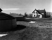
ARCH 2: North Lauder Locale The North Lauder locale has a long archaeological and geological history that is important for understanding the forces that shaped the region. Archaeological research in the locale shows that the area has been occupied by humans for at least the past 6,500 years. Environmental forces provided an area of diverse resources that attracted early peoples. Environment of the Lauder Sandhills The North Lauder locale is part of the greater Lauder Sandhills area. The glaciers that covered this region began to recede approximately 11,000 years ago leaving a large lake known as glacial Lake Hind. The Souris River, the Lauder Sandhills and the Oak Lake Aquifer are remnants of the environmental and geological forces that shaped the region. The Lauder Sandhills region is characterized by a landscape of sand sheets and stabilized sand dunes interspersed with a variety of wetlands. This complex topographic and hydrological situation favoured the development of an island mosaic of mixed forest, wetland and meadow, surrounded by mixed grass prairie. The result was a large, isolated ecotone which provided a rich variety of subsistence resources for hunter-gatherers. Research in the Lauder Sandhills Archaeologists from Brandon University have been conducting research in the Lauder Sandhills since 1991. Research in the North Lauder locale has focused on the Atkinson site, a 6,500 year old hunter-gatherer site and Flintstone Hill. The Atkinson site 
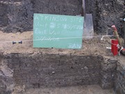
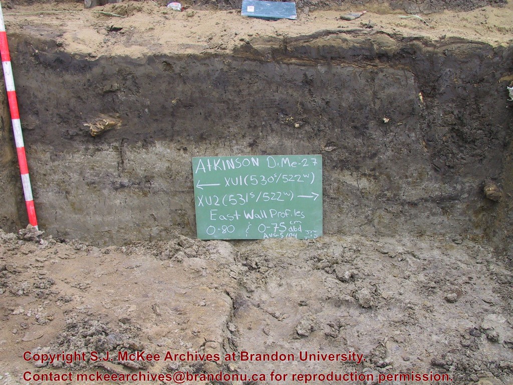
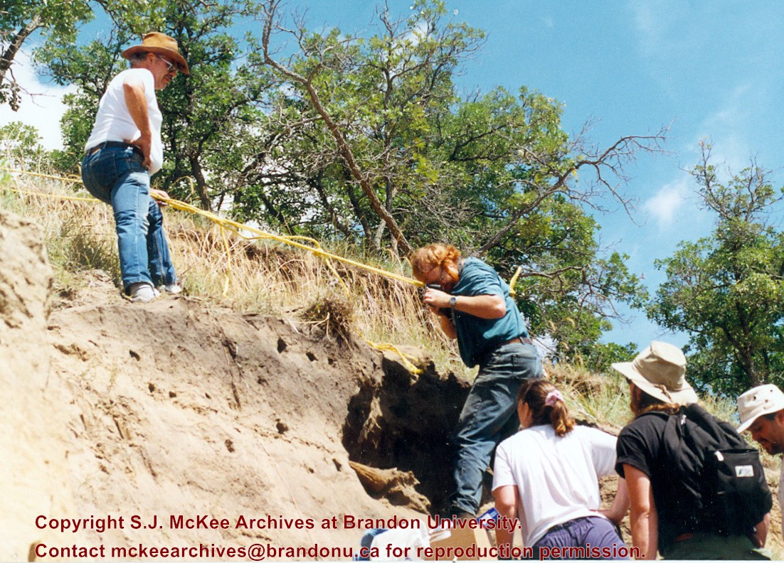
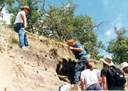
The Atkinson site is one of the oldest excavated sites in Manitoba and has been Radiocarbon dated to 6,500 years before present. The Atkinson site is located on the bank of the Souris River and was discovered when a hearth (fire pit) was seen eroding out of the bank. Based on the date of the site and the kind of lithics (stone tools) present it is considered a Gowen occupation. The Atkinson site is evidence that bison hunters were active on the northern plains at a very early date. Similar sites have also been found on the High Plains in the U.S. and are referred to as the Mummy Cave Complex. The Atkinson Site is of great importance as it is the first undisturbed site of this type to be excavated in Manitoba and extends the range of these sites south and east from the type-sites in central Saskatchewan.
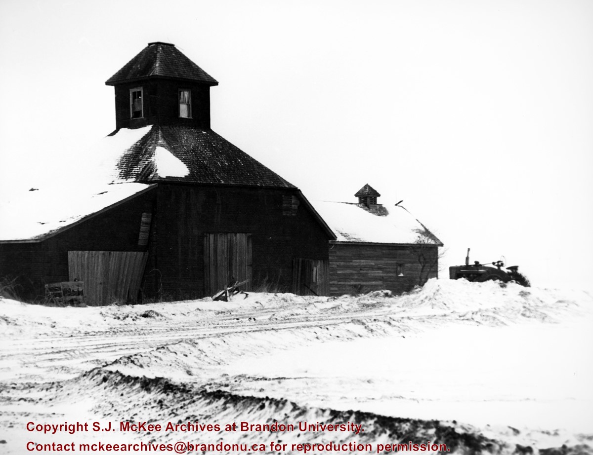
 Flintstone Hill 
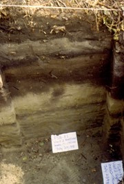
The geomorphology of the glacial Lake Hind Basin over the past 11,000 years is known primarily through the study of a cut bank along the Souris River. Flint Stone Hill contains the most complete stratigraphic record for the post-glacial period on the northern plains. The site has been extensively studied by geoarchaeologists, geologists and paleoenvironmentalists over many years and their findings have contributed to our understanding of the region. The North Lauder locale Borden designations of Atkinson site DiMe-27 and Flintstone Hill site DiMe-26. Borden System Archaeological sites in Canada are identified by the Borden system, which is a uniform site designation system. The country is divided into grids based on latitude and longitude in blocks of 10 x 20 minutes. The first 4 letters indicate the block and the following numbers indicate the actual site. For example the area of the Lauder Sandhills in southwestern Manitoba is identified by the letters DM and the North Lauder locale within that area is DiMe. The Atkinson site is DiMe-27 and the Flintstone Hill site DiMe-26. As new sites are discovered they will be numbered sequentially.
Scope and Content
The Series has been divided into two sub-series, including (1) Atkinson site DiMe-27 and Flintstone Hill site DiMe-26.
Name Access
North Lauder locale
Subject Access
Archaeology Atkinson site DiMe-27
Arrangement
Series is arranged by site and by year of field work.
Show Less

Atkinson site 2003 - Unit 2

http://archives.brandonu.ca/en/permalink/descriptions12174
Part Of
RG 7 Beverley Nicholson fonds
Description Level
Item
GMD
graphic
Date Range
2003
Accession Number
1-2010
Part Of
RG 7 Beverley Nicholson fonds
Description Level
Item
Series Number
2.1.1.5
Item Number
2.1.1.5.4
Accession Number
1-2010
GMD
graphic
Date Range
2003
Physical Description
600 x 450 (330 KB )
Material Details
JPEG
History / Biographical
Photograph taken during 2003 Brandon University Archaeology excavations at Atkinson site.
Scope and Content
Atkinson site 2003 Unit 2.
Name Access
Atkinson site 2003 - Unit 2
Subject Access
Archaeology North lauder locale Atkinson site DiMe-27 Atkinson site 2003 photographs
Images
Show Less

Atkinson site 2004 - east wall of XU 1 and 2

http://archives.brandonu.ca/en/permalink/descriptions12213
Part Of
RG 7 Beverley Nicholson fonds
Description Level
Item
GMD
graphic
Date Range
2004
Accession Number
1-2010
Part Of
RG 7 Beverley Nicholson fonds
Description Level
Item
Series Number
2.1.2.5
Item Number
2.1.2.5.8
Accession Number
1-2010
GMD
graphic
Date Range
2004
Physical Description
1024 x 768 (416 KB)
Material Details
JPEG
History / Biographical
Photograph taken during 2004 Brandon University Archaeology excavations at Atkinson site.
Scope and Content
Excavation units 1 and 2, east wall.
Name Access
Atkinson site 2004 - east wall of XU 1 and 2
Subject Access
Archaeology North lauder locale Atkinson site DiMe-27 Atkinson site 2004 photographs
Images
Show Less

Atkinson site 2004 - east wall of XU 2

http://archives.brandonu.ca/en/permalink/descriptions12216
Part Of
RG 7 Beverley Nicholson fonds
Description Level
Item
GMD
graphic
Date Range
2004
Accession Number
1-2010
Part Of
RG 7 Beverley Nicholson fonds
Description Level
Item
Series Number
2.1.2.5
Item Number
2.1.2.5.11
Accession Number
1-2010
GMD
graphic
Date Range
2004
Physical Description
1024 x 768 (457 KB)
Material Details
JPEG
History / Biographical
Photograph taken during 2004 Brandon University Archaeology excavations at Atkinson site.
Scope and Content
Excavation unit 2, east wall profile.
Name Access
Atkinson site 2004 - east wall of XU 2
Subject Access
Archaeology North lauder locale Atkinson site DiMe-27 Atkinson site 2004 photographs
Images
Show Less

Flintstone Hill 1997 - photography on cliff edge 2

http://archives.brandonu.ca/en/permalink/descriptions12309
Part Of
RG 7 Beverley Nicholson fonds
Description Level
Item
GMD
graphic
Date Range
1997
Accession Number
1-2010
Part Of
RG 7 Beverley Nicholson fonds
Description Level
Item
Series Number
2.2.1.5
Item Number
2.2.1.5.6
Accession Number
1-2010
GMD
graphic
Date Range
1997
Physical Description
1102 x 792(530)
Material Details
JPEG
History / Biographical
Photograph taken during 1997 Brandon University Archaeology survey at Flintstone Hill.
Scope and Content
Scott Hamilton photographing bison skull from the edge of the cliff.
Name Access
Flintstone Hill 1997 - photography on cliff edge 2
Subject Access
Archaeology North lauder locale Flintstone Hill DiMe-26 Flintstone Hill 1997 - photography on cliff edge 2
Images
Show Less

Flintstone Hill 1998-2000 - Test Unit 2 east profile

http://archives.brandonu.ca/en/permalink/descriptions12317
Part Of
RG 7 Beverley Nicholson fonds
Description Level
Item
GMD
graphic
Date Range
1998-2000
Accession Number
1-2010
Part Of
RG 7 Beverley Nicholson fonds
Description Level
Item
Series Number
2.2.2.5
Item Number
2.2.2.5.4
Accession Number
1-2010
GMD
graphic
Date Range
1998-2000
Physical Description
536 x 792(293)
Material Details
JPEG
History / Biographical
Photograph taken during 1998-2000 Brandon University Archaeology survey at Flintstone Hill.
Scope and Content
Test Unit 2 east profile.
Name Access
Flintstone Hill 1998-2000 - Test Unit 2 east profile
Subject Access
Archaeology North lauder locale Flintstone Hill DiMe-26 Flintstone Hill 1998-2000 - Test Unit 2 east profile
Images
Show Less

Residential property, Brandon, Manitoba

http://archives.brandonu.ca/en/permalink/descriptions8345
Part Of
Joseph H. Hughes collection
Description Level
Item
GMD
graphic
Accession Number
3-1997
Part Of
Joseph H. Hughes collection
Description Level
Item
Series Number
3-1997.1
Item Number
3-1997.1.1
Accession Number
3-1997
GMD
graphic
Physical Description
8" x 10" (b/w)
Physical Condition
good
Scope and Content
Photograph of an Edwardian era family residence, south central Brandon.
Notes
Back of photograph is stamped: Hughes & Co. Ltd.
Subject Access
residential streets
residences
Storage Location
RG 5 photograph storage drawer
Images
Show Less

Victorian row housing block, Brandon, Manitoba

http://archives.brandonu.ca/en/permalink/descriptions8371
Part Of
Joseph H. Hughes collection
Description Level
Item
GMD
graphic
Date Range
[1900s]
Accession Number
3-1997
Part Of
Joseph H. Hughes collection
Description Level
Item
Series Number
3-1997.1
Item Number
3-1997.1.2
Accession Number
3-1997
GMD
graphic
Date Range
[1900s]
Physical Description
7 3/4" x 10" (b/w)
Physical Condition
good
Scope and Content
Photograph of an Victorian row housing block - possibly 7th Street 300-block, Brandon, Manitoba.
Notes
Writing on back of photograph reads: City 1295, Hughes Est.
Subject Access
residences
residential streets
Storage Location
RG 5 photograph storage drawer
Images
Show Less

Northeast corner 10th Street and Princess Avenue, Brandon, Manitoba (2)

http://archives.brandonu.ca/en/permalink/descriptions8374
Part Of
Joseph H. Hughes collection
Description Level
Item
GMD
graphic
Date Range
1962
Accession Number
3-1997
Part Of
Joseph H. Hughes collection
Description Level
Item
Series Number
3-1997.1
Item Number
3-1997.1.4
Accession Number
3-1997
GMD
graphic
Date Range
1962
Physical Description
8" x 10" (b/w)
Physical Condition
good
Scope and Content
Photograph shows a view of downtown Brandon from the northeast corner of 10th Street and Princess Avenue. Thunderbird Bowl is in the foreground. Painted advertisements on the sides of buildings include: The Mitrou's Cafe and Tea Room and Brandon Musical Supply Ltd. Vehicles parked on 10th Street are facing north.
Notes
Photograph dated from "Tara's Bulba," the movie playing at the Strand Theatre and similiar vehicles captured in the photograph.
Name Access
Thunderbird Bowl
Mitrou Building
Brandon Musical Supply Ltd.
10th Street
Subject Access
downtowns
Brandon business buildings & facilities after 1940
Storage Location
RG 5 photograph storage drawer
Images
Show Less

Corner of 10th Street and Princess Avenue, Brandon, Manitoba

http://archives.brandonu.ca/en/permalink/descriptions8387
Part Of
Joseph H. Hughes collection
Description Level
Item
GMD
graphic
Date Range
c. 1930
Accession Number
3-1997
Part Of
Joseph H. Hughes collection
Description Level
Item
Series Number
3-1997.1
Item Number
3-1997.1.14
Accession Number
3-1997
GMD
graphic
Date Range
c. 1930
Physical Description
8 " x 10" (b/w)
Physical Condition
good
Scope and Content
Photograph shows the intersection of 10th Street and Princess Avenue, Brandon, Manitoba. View is facing northwest along west side of the 100-block of 10th Street. A stationary policeman/divider is at the centre of the intersection. Visible businesses include: Doig's, Plaza Shoe Shop, and Cambridge Clothes Shop. A horse-drawn sled is parked in front of Doig's store. The Olympia Block, Cecil Hotel, and CPR Station are visible in the background.
Name Access
Doig's
Plaza Shoe Shop
Cambridge Clothes Shop
Alexandra Block
Strathcona Block
10th Street
Princess Avenue
Subject Access
downtowns
street scenes
Brandon business buildings & facilities before 1940
building exteriors
Transportation
Storage Location
RG 5 photograph storage drawer
Images
Show Less

100-block 10th Street, facing southwest (2)

http://archives.brandonu.ca/en/permalink/descriptions8407
Part Of
Joseph H. Hughes collection
Description Level
Item
GMD
graphic
Date Range
c. 1950
Accession Number
3-1997
Part Of
Joseph H. Hughes collection
Description Level
Item
Series Number
3-1997.1
Item Number
3-1997.1.29
Accession Number
3-1997
GMD
graphic
Date Range
c. 1950
Physical Description
8 " x 10" (b/w)
Physical Condition
good
Scope and Content
Photograph shows the west side of 10th Street between Rosser and Princess Avenues. Visible businesses include: Recreation Bowling & Billiards, Bottomley's, Barry Neill Men's Wear, Simpsons-Sears, Allied Hardware Stores, Box Brothers Hardware, Doig's. Painted on the north face of the Strathcona Block are two advertisements, one for Sutherland and Robertson [Grocery] and the other for Boyd Electric Co. Ltd.
Name Access
10th Street
Recreation Bowling and Billiards
Bottomley's
Barry Neill Men's Wear
Simpsons-Sears Ltd.
Sutherland and Robertson
Boyd Electric Co. Ltd.
Strathcona Block
Box Brothers Hardware
Doig's
Allied Hardware
Alexandra Block
Subject Access
downtowns
street scenes
Brandon business buildings & facilities after 1940
building exteriors
Storage Location
RG 5 photograph storage drawer
Images
Show Less

Aerial view of 10th Street facing south from Princess Avenue

http://archives.brandonu.ca/en/permalink/descriptions8420
Part Of
Joseph H. Hughes collection
Description Level
Item
GMD
graphic
Date Range
c.1940
Accession Number
3-1997
Part Of
Joseph H. Hughes collection
Creator
Photographer: Jerrett Photo
Description Level
Item
Series Number
3-1997.1
Item Number
3-1997.1.42
Accession Number
3-1997
GMD
graphic
Date Range
c.1940
Physical Description
5.5" x 3.5" (b/w)
Material Details
postcard
Physical Condition
Red ink stain is on the front right corner of postcard
Scope and Content
Photograph shows 10th Street facing south from Princess Avenue. Visible landmarks and businesses include: Manitoba Power Commission (MPC)'s power sub-station, First Baptist Church, Wheat City Arena, and the grand stand at the Exhibition Grounds. The partial sign visible at the bottom of the photograph on the east side of 10th Street reads Yates and Neale, which refers to a plumbing and heating company that dissolved in 1943 to be replaced by Neale, Stothard and Chapman. Businesses on the west side of 10th Street include: Dominion Tire & Radio Co., Bolts Barber Shop, Elviss T.E. Co. Stables.
Notes
Information concerning Yates and Neale courtesy Jack Stothard. Writing on the front of the postcard reads: Brandon, Looking S.W., Jerrett Photo. This photograph shows a rare view of the 200-block of 10th Street.
Name Access
Manitoba Power Company
10th Street
Dominion Tire & Radio Co.
T.E. Elviss Co. Stables
First Baptist Church
Subject Access
downtowns
street scenes
Brandon business buildings & facilities before 1940
aerial views
building exteriors
residences
churches
Storage Location
RG 5 photograph storage drawer
Images
Show Less
Part Of
RG 11 Lawrence Stuckey fonds
Description Level
Item
GMD
graphic
Date Range
December 12, 1978
Accession Number
1-2002
Part Of
RG 11 Lawrence Stuckey fonds
Creator
Lawrence Stuckey
Description Level
Item
Series Number
3.9
Item Number
1-2002.3.9.68
Accession Number
1-2002
GMD
graphic
Date Range
December 12, 1978
Physical Description
8" x 10" (b/w)
History / Biographical
Stuckey's notes: west side P.R. 258 north of Carberry, Man.
Scope and Content
Photograph shows an old wooden octagonal shaped farm building that may have been a granary.
Notes
Corresponds with negative RA - CPR Carberry Sub [88c].
Repro Restriction
The McKee Archives is the copyright holder for the Stuckey materials.
Storage Location
RG 5 photograph storage drawer
Related Material
RA - CPR Carberry Sub [88a] to [88g].
Images
Show Less

Farm abandoned with stored grain

http://archives.brandonu.ca/en/permalink/descriptions8693
Part Of
RG 11 Lawrence Stuckey fonds
Description Level
Item
GMD
graphic
Date Range
May 1970
Accession Number
1-2002
Part Of
RG 11 Lawrence Stuckey fonds
Creator
Lawrence Stuckey
Description Level
Item
Series Number
3.9
Item Number
1-2002.3.9.73
Accession Number
1-2002
GMD
graphic
Date Range
May 1970
Physical Description
8" x 10" (b/w)
Scope and Content
Photograph shows the abandoned farm house and yard, with two round storage bins.
Notes
Corresponds with negative History - Miscellaneous [34c]
Repro Restriction
The McKee Archives is the copyright holder for the Stuckey materials.
Storage Location
RG 5 photograph storage drawer
Related Material
History - Miscellaneous [34a] to [34g]
Images
Show Less

Brandon House No. 2 cairn

http://archives.brandonu.ca/en/permalink/descriptions8697
Part Of
RG 11 Lawrence Stuckey fonds
Description Level
Item
GMD
graphic
Date Range
1961
Accession Number
1-2002
Part Of
RG 11 Lawrence Stuckey fonds
Creator
Lawrence Stuckey
Description Level
Item
Series Number
3.9
Item Number
1-2002.3.9.79
Accession Number
1-2002
GMD
graphic
Date Range
1961
Physical Description
5" x 7" (b/w)
Scope and Content
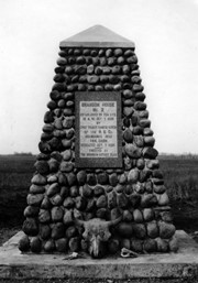
Photograph shows the cairn and the plaque on it. There is a skull at the base of the cairn. Plaque reads: Brandon House No. 2 established on this site 10am Oct. 7, 1828 by Chief Trader Francis Heron of the H.B. Co. Abandoned 1832. This cairn dedicated Oct. 7, 1928 - erected by The Brandon Rotary Club.
Repro Restriction
The McKee Archives is the copyright holder for the Stuckey materials.
Storage Location
RG 5 photograph storage drawer
Related Material
History - Miscellaneous [NA7].
Images
Show Less

Old farm buildings

http://archives.brandonu.ca/en/permalink/descriptions8701
Part Of
RG 11 Lawrence Stuckey fonds
Description Level
Item
GMD
graphic
Date Range
December 12, 1978
Accession Number
1-2002
Part Of
RG 11 Lawrence Stuckey fonds
Creator
Lawrence Stuckey
Description Level
Item
Series Number
3.9
Item Number
1-2002.3.9.83
Accession Number
1-2002
GMD
graphic
Date Range
December 12, 1978
Physical Description
8" x 10" (b/w)
History / Biographical
Stuckey's notes: west side P.R. 258 north of Carberry, MB.
Scope and Content
Photograph shows two farmbuildings and an old tractor.
Notes
Corresponds with negative RA - CPR Carberry Sub. [88a]
Repro Restriction
The McKee Archives is the copyright holder for the Stuckey materials.
Storage Location
RG 5 photograph storage drawer
Related Material
RA - CPR Carberry Sub. [88a] to [88g].
Images
Show Less

20 records – page 1 of 1.