Skip header and navigation

Revise Search

20 records – page 1 of 1.

Aerial view: Brandon College

http://archives.brandonu.ca/en/permalink/descriptions594
Part Of
Brandon University Photograph collection
Description Level
Item
GMD
graphic
Date Range
[fall 1964?]
Part Of
Brandon University Photograph collection
Description Level
Item
Series Number
2.1
Item Number
BUPC 2.1.2
GMD
graphic
Date Range
[fall 1964?]
Physical Description
5" x 4" (b/w)
Scope and Content
Brandon College looking south from 19th Street. Photograph was taken after Flora Cowan Hall was built but before construction of the Education Building.
Subject Access
aerial photographs
campus photographs
campus buildings
Brandon streets
Images
Show Less

Aerial view: Brandon College and downtown east

http://archives.brandonu.ca/en/permalink/descriptions597
Part Of
Aerial views and campus photographs
Description Level
Item
GMD
graphic
Date Range
c. spring 1963
Part Of
Aerial views and campus photographs
Description Level
Item
Series Number
2.1
Item Number
2.1.5
GMD
graphic
Date Range
c. spring 1963
Physical Description
10" x 8" (b/w)
Scope and Content
View is east southeast from approximately 22nd Street between Princess and Louise Avenues. Photograph shows: Brandon College, Stanley Park, Park School, Prince Edward Hotel, First Baptist Church, First Presbyterian Church, Wheat City Arena, First Church United, St. Paul's, Central United Church.
Images
Show Less

Aerial view - Brandon College looking southwest

http://archives.brandonu.ca/en/permalink/descriptions601
Part Of
Brandon University Photograph collection
Description Level
Item
GMD
graphic
Date Range
[1963-1966]
Part Of
Brandon University Photograph collection
Description Level
Item
Series Number
2.1
Item Number
BUPC 2.1.8
GMD
graphic
Date Range
[1963-1966]
Physical Description
5" x 4" (b/w)
Scope and Content
Image shows the Brandon College campus from 17th Street looking southwest. The photo was taken after the completion of the original Music Building in 1963, but construction of the Education Building. Also visible are a number of properties on the 200 block of 18th Street and the 200 block of 20th Street.
Subject Access
aerial photographs
campus photographs
campus buildings
Brandon streets
Images
Show Less

Aerial view: Brandon College from 23rd Street

http://archives.brandonu.ca/en/permalink/descriptions602
Part Of
Brandon University Photograph collection
Description Level
Item
GMD
graphic
Date Range
[1963-1966]
Part Of
Brandon University Photograph collection
Description Level
Item
Series Number
2.1
Item Number
BUPC 2.1.9
GMD
graphic
Date Range
[1963-1966]
Physical Description
5" x 4" (b/w)
Scope and Content
Image is looking east northeast from approximately the 300 block of 23rd Street between Lorne and Louise Avenues. Photograph shows the Brandon College campus after the opening of the original Music Building in 1963, but before the construction of the Education Building in 1966. A number of house on the 300 blocks of 22nd and 21st Streets are visible in the foreground, with the A.E. McKenzie Seed Co., the Prince Edward Hotel and various grain elevators on the horizon.
Subject Access
aerial photographs
campus photographs
campus buildings
Brandon streets
Grain elevators
Images
Show Less

Aerial view: Brandon College looking east

http://archives.brandonu.ca/en/permalink/descriptions617
Part Of
Aerial views and campus photographs
Description Level
Item
GMD
graphic
Date Range
c. 1963
Part Of
Aerial views and campus photographs
Description Level
Item
Series Number
2.1
Item Number
2.1.25
GMD
graphic
Date Range
c. 1963
Physical Description
5" x 4" (b/w)
Scope and Content
View is east from approximatley 22nd Street between Lorne and Louise Avenues. Photograph shows: Darrach Hall, Flora Cowan Hall and the Citizens' Science Building, as well as a number of homes in the area.
Images
Show Less

East side of the Main Dining Room

http://archives.brandonu.ca/en/permalink/descriptions653
Part Of
Residences and dining rooms
Description Level
Item
GMD
graphic
Date Range
Summer 1963
Part Of
Residences and dining rooms
Creator
Photographer: Henry Kalen
Description Level
Item
Series Number
2.6
Item Number
2.6.27
Other Numbers
Proof (218 D3.1-19)
GMD
graphic
Date Range
Summer 1963
Physical Description
4" x 5.5" (b/w)
Material Details
Contact print
Scope and Content
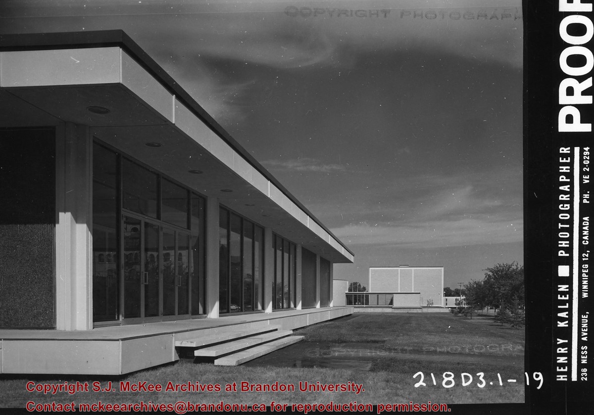
Photograph is looking north and shows the east side of the Main Dining Room. The J.R.C. Evans Lecture Theatre, the A.E. McKenzie Building, the link between the two buildings and the Original Music Building are visible in the background.
Repro Restriction
Copyright restrictions apply.
Images
Show Less

East entrance to the Main Dining Room

http://archives.brandonu.ca/en/permalink/descriptions655
Part Of
Residences and dining rooms
Description Level
Item
GMD
graphic
Date Range
Summer 1963
Part Of
Residences and dining rooms
Creator
Photographer: Henry Kalen
Description Level
Item
Series Number
2.6
Item Number
2.6.28
Other Numbers
Proof (218 D3.1-21)
GMD
graphic
Date Range
Summer 1963
Physical Description
4" x 5.5" (b/w)
Material Details
Contact print.
Scope and Content
Photograph is looking west and shows the east entrance to the Main Dining Room. The link to Flora Cowan Hall and part of both Flora Cowan Hall and Darrach Hall are visible in the background.
Repro Restriction
Copyright restrictions apply.
Images
Show Less

Site Services Building

http://archives.brandonu.ca/en/permalink/descriptions710
Part Of
Brandon University Photograph Collection
Description Level
Item
GMD
graphic
Date Range
[197-]
Part Of
Brandon University Photograph Collection
Description Level
Item
Series Number
2.12
Item Number
BUPC 2.12.5
GMD
graphic
Date Range
[197-]
Physical Description
8" x 10" (b/w)
History / Biographical
The Site Services building was built in 1971.
Scope and Content
Photograph is looking northwest and shows the exterior of the Site Services Building located on at 20th Street and Louise Avenue.
Images
Show Less

East side of the A.E. McKeznie Building

http://archives.brandonu.ca/en/permalink/descriptions861
Part Of
Brandon University Photograph collection
Description Level
Item
GMD
graphic
Date Range
c .1985
Part Of
Brandon University Photograph collection
Description Level
Item
Series Number
2.4
Item Number
BUPC 2.4.1
GMD
graphic
Date Range
c .1985
Physical Description
3.5" x 5" (colour)
Scope and Content
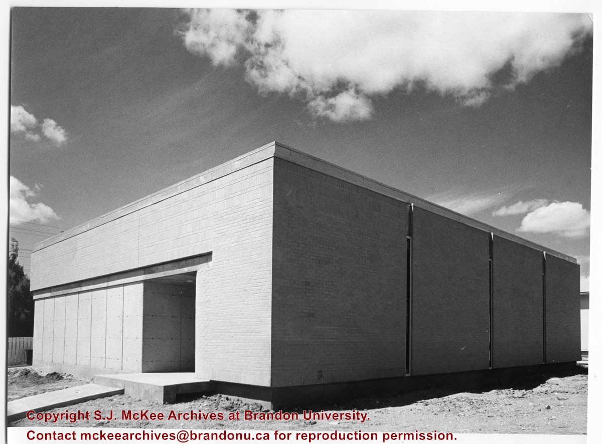
Photograph is looking west from the sidewalk between Clark Hall and the Education Building and shows the east side of the A.E. McKenzie Building as well as a trailer that housed the Canada Manpower office (career councelling) in the 1960s. The trailer was later moved near the Kinsmen Stadium where it housed the Quill office.
Images
Show Less

Northfield School and pony barn, 6 miles east of Wawanesa, Manitoba

http://archives.brandonu.ca/en/permalink/descriptions11105
Part Of
RG 11 Lawrence Stuckey fonds
Description Level
Item
GMD
graphic
Date Range
Oct. 28, 1979
Part Of
RG 11 Lawrence Stuckey fonds
Creator
L.A. Stuckey
Description Level
Item
Series Number
3.3
Item Number
1-2002.3.3.BSE[363a]
GMD
graphic
Date Range
Oct. 28, 1979
Physical Description
2.5" x 3"
Material Details
Negative
History / Biographical
Mr. Stuckey's notes: : Purchased by the Mooney family for use as a community center, after closure as a school.
Custodial History
For custodial history see the collection level description of the Lawrence Stuckey collection.
Scope and Content
Image of Northfield School and pony barn, 6 miles east of Wawanesa, Manitoba.
Notes
[Brandon SE includes communities south of Trans-Canada #1 highway and east of PTH #10.]
Name Access
Northfield School
Wawanesa, Manitoba
Subject Access
schools
barns
community centres
Storage Location
Lawrence Stuckey collection
Arrangement
[Mr. Stuckey put two negatives in the same envelope. We have separated them and numbered the negatives (363a) and (363b].
Images
Show Less

Northfield School and pony barn, 6 miles east of Wawanesa, Manitoba

http://archives.brandonu.ca/en/permalink/descriptions11113
Part Of
RG 11 Lawrence Stuckey fonds
Description Level
Item
GMD
graphic
Date Range
Oct. 28, 1979
Part Of
RG 11 Lawrence Stuckey fonds
Creator
L.A. Stuckey
Description Level
Item
Series Number
3.3
Item Number
1-2002.3.3.BSE[363b]
GMD
graphic
Date Range
Oct. 28, 1979
Physical Description
2.5" x 3.5"
Material Details
Negative
History / Biographical
Mr. Stuckey's notes: : Purchased by the Mooney family for use as a community center, after closure as a school.
Custodial History
For custodial history see the collection level description of the Lawrence Stuckey collection.
Scope and Content
Image of Northfield School and pony barn, 6 miles east of Wawanesa, Manitoba.
Notes
[Brandon SE includes communities south of Trans-Canada #1 highway and east of PTH #10.]
Name Access
Northfield School
Wawanesa, Manitoba
Subject Access
schools
community centres
Storage Location
Lawrence Stuckey collection
Arrangement
[Mr. Stuckey put two negatives in the same envelope. We have separated them and numbered the negatives (363a) and (363b].
Images
Show Less
Part Of
CKX fonds
Description Level
Item
GMD
graphic
Date Range
1969
Accession Number
11-2010
Part Of
CKX fonds
Creator
CKX
Description Level
Item
Item Number
11-2010.A39
Accession Number
11-2010
GMD
graphic
Date Range
1969
Physical Description
2.25" x 2.25" (b/w)
Material Details
Negative
Custodial History
See fonds level of the CKX records for custodial history.
Scope and Content
Image of items that were part of an ARP 1 cent sale.
Name Access
CKX Television
ARP
Subject Access
television broadcasting
retail trade
Storage Location
CKX fonds - 2010 accessions
Images
Show Less

British American dealers (Highways 1 and 10, Brandon)

http://archives.brandonu.ca/en/permalink/descriptions11202
Part Of
CKX fonds
Description Level
Item
GMD
graphic
Date Range
after 1954
Accession Number
11-2010
Part Of
CKX fonds
Creator
CKX
Description Level
Item
Item Number
11-2010.B2o
Accession Number
11-2010
GMD
graphic
Date Range
after 1954
Physical Description
2.25" x 2.25" (b/w)
Material Details
Negative
Custodial History
See fonds level of the CKX records for custodial history.
Scope and Content
Image consists of British American dealers (Highways 1 and 10, Brandon).
Name Access
CKX
British American Dealers
Brandon, Manitoba
Subject Access
automobile dealerships
Storage Location
CKX fonds - 2010 accessions
Images
Show Less

British American dealers - aerial view looking north at intersection of Highways 1 and 10

http://archives.brandonu.ca/en/permalink/descriptions11240
Part Of
CKX fonds
Description Level
Item
GMD
graphic
Date Range
after 1954
Accession Number
11-2010
Part Of
CKX fonds
Creator
CKX
Description Level
Item
Item Number
11-2010.B3u
Accession Number
11-2010
GMD
graphic
Date Range
after 1954
Physical Description
5" x 4" (b/w)
Material Details
Negative
Custodial History
See fonds level of the CKX records for custodial history.
Scope and Content
Image consists of an aerial view looking north at the intersection of Highways 1 and 10 and shows the British American dealer located at the intersection.
Name Access
CKX
British American Dealers
Brandon, Manitoba
Subject Access
aerial photographs
Storage Location
CKX fonds - 2010 accessions
Images
Show Less

British American dealers - aerial view looking southeast from intersection of Highways 1 and 10

http://archives.brandonu.ca/en/permalink/descriptions11242
Part Of
CKX fonds
Description Level
Item
GMD
graphic
Date Range
after 1954
Accession Number
11-2010
Part Of
CKX fonds
Creator
CKX
Description Level
Item
Item Number
11-2010.B3v
Accession Number
11-2010
GMD
graphic
Date Range
after 1954
Physical Description
5" x 4" (b/w)
Material Details
Negative
Custodial History
See fonds level of the CKX records for custodial history.
Scope and Content
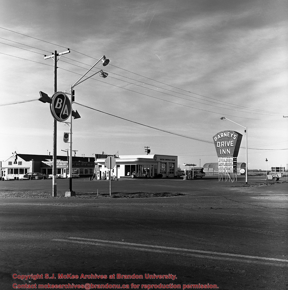
Image consists of an aerial view looking southeast at the intersection of Highways 1 and 10 and shows the British American dealer located at the intersection.
Name Access
CKX
British American Dealers
Brandon, Manitoba
Subject Access
aerial photographs
Storage Location
CKX fonds - 2010 accessions
Images
Show Less

British American dealers - aerial view looking northeast from intersection of Highways 1 and 10

http://archives.brandonu.ca/en/permalink/descriptions11243
Part Of
CKX fonds
Description Level
Item
GMD
graphic
Date Range
after 1954
Accession Number
11-2010
Part Of
CKX fonds
Creator
CKX
Description Level
Item
Item Number
11-2010.B3w
Accession Number
11-2010
GMD
graphic
Date Range
after 1954
Physical Description
5" x 4" (b/w)
Material Details
Negative
Custodial History
See fonds level of the CKX records for custodial history.
Scope and Content
Image consists of an aerial view looking northeast at the intersection of Highways 1 and 10 and shows the British American dealer located at the intersection.
Name Access
CKX
British American Dealers
Brandon, Manitoba
Subject Access
aerial photographs
Storage Location
CKX fonds - 2010 accessions
Images
Show Less
Part Of
CKX fonds
Description Level
Item
GMD
graphic
Date Range
after 1954
Accession Number
11-2010
Part Of
CKX fonds
Creator
CKX
Description Level
Item
Item Number
11-2010.B43
Accession Number
11-2010
GMD
graphic
Date Range
after 1954
Physical Description
5" x 4" (b/w)
Material Details
Negative
Custodial History
See fonds level of the CKX records for custodial history.
Scope and Content
Image consists of a picture of G. Box.
Name Access
CKX Television
G. Box
Subject Access
portraits
photographs
Storage Location
CKX fonds - 2010 accessions
Images
Show Less

Church, Smart, Manitoba (2 miles north, 1 mile east of)

http://archives.brandonu.ca/en/permalink/descriptions11412
Part Of
RG 11 Lawrence Stuckey fonds
Description Level
Item
GMD
graphic
Date Range
December 19, 1978; August 4, 1979
Accession Number
1-2002
Part Of
RG 11 Lawrence Stuckey fonds
Creator
L.A. Stuckey
Description Level
Item
Series Number
3.3
Item Number
1-2002.3.3.CNR[149b]
Accession Number
1-2002
GMD
graphic
Date Range
December 19, 1978; August 4, 1979
Physical Description
2.25" x 2.25" (b/w)
Material Details
Negative
History / Biographical
Stuckey's notes: St. George's, Elton district, built 1901.
Custodial History
For custodial history see the collection level description of the Lawrence Stuckey collection.
Scope and Content
Image of a church at Smart, Manitoba (2 miles north, 1 mile east), taken along the CNR mainline, Rivers substation.
Name Access
CNR
Smart, Manitoba
Subject Access
railways
Church buildings/Churches
Repro Restriction
The McKee Archives is the copyright holder of the Stuckey materials.
Storage Location
Lawrence Stuckey collection
Arrangement
[Mr. Stuckey put three negatives in same envelope. We have separated them and numbered them (149a) to (149c)].
Images
Show Less

Brandon streets - Rosser Avenue looking east from the 1100 block

http://archives.brandonu.ca/en/permalink/descriptions11554
Part Of
CKX fonds
Description Level
Item
GMD
graphic
Date Range
after 1954
Accession Number
11-2010
Part Of
CKX fonds
Creator
CKX
Description Level
Item
Item Number
11-2010.B103c
Accession Number
11-2010
GMD
graphic
Date Range
after 1954
Physical Description
5" x 4" (b/w)
Material Details
Negative
Custodial History
See fonds level of the CKX records for custodial history.
Scope and Content
Image of Rosser Avenue looking east from the 1100 block.
Name Access
CKX
Brandon, Manitoba
Subject Access
steetscapes
Storage Location
CKX fonds - 2010 accessions
Images
Show Less

Brandon streets - Princess Avenue looking east from 10th Street

http://archives.brandonu.ca/en/permalink/descriptions11556
Part Of
CKX fonds
Description Level
Item
GMD
graphic
Date Range
after 1954
Accession Number
11-2010
Part Of
CKX fonds
Creator
CKX
Description Level
Item
Item Number
11-2010.B103e
Accession Number
11-2010
GMD
graphic
Date Range
after 1954
Physical Description
5" x 4" (b/w)
Material Details
Negative
Custodial History
See fonds level of the CKX records for custodial history.
Scope and Content
Image of Princess Avenue looking east from 10th Street.
Name Access
CKX
Brandon, Manitoba
Subject Access
steetscapes
Storage Location
CKX fonds - 2010 accessions
Images
Show Less

20 records – page 1 of 1.