Skip header and navigation

Revise Search

20 records – page 1 of 1.

Aerial view: Brandon College from 23rd Street

http://archives.brandonu.ca/en/permalink/descriptions602
Part Of
Brandon University Photograph collection
Description Level
Item
GMD
graphic
Date Range
[1963-1966]
Part Of
Brandon University Photograph collection
Description Level
Item
Series Number
2.1
Item Number
BUPC 2.1.9
GMD
graphic
Date Range
[1963-1966]
Physical Description
5" x 4" (b/w)
Scope and Content
Image is looking east northeast from approximately the 300 block of 23rd Street between Lorne and Louise Avenues. Photograph shows the Brandon College campus after the opening of the original Music Building in 1963, but before the construction of the Education Building in 1966. A number of house on the 300 blocks of 22nd and 21st Streets are visible in the foreground, with the A.E. McKenzie Seed Co., the Prince Edward Hotel and various grain elevators on the horizon.
Subject Access
aerial photographs
campus photographs
campus buildings
Brandon streets
Grain elevators
Images
Show Less

Aerial view: Brandon College campus from north

http://archives.brandonu.ca/en/permalink/descriptions615
Part Of
Aerial views and campus photographs
Description Level
Item
GMD
graphic
Date Range
c. 1963
Part Of
Aerial views and campus photographs
Description Level
Item
Series Number
2.1
Item Number
2.1.23
GMD
graphic
Date Range
c. 1963
Physical Description
5" x 4" (b/w)
Scope and Content
View is north, taken from approximatley 19th Street and Rosser Avenue. Photograph shows: Clark Hall, the A.E. McKenzie Building, the J.R.C. Evans Lecture Theatre, H-Huts, Darrach Hall and Flora Cowan Hall, as well as a number of homes in the area.
Images
Show Less

Main library reading room

http://archives.brandonu.ca/en/permalink/descriptions792
Part Of
Brandon University Photograph collection
Description Level
Item
GMD
graphic
Date Range
c. 1960s
Part Of
Brandon University Photograph collection
Description Level
Item
Series Number
2.4
Item Number
BUPC 2.4.12
GMD
graphic
Date Range
c. 1960s
Physical Description
8" x 10" (b/w)
History / Biographical
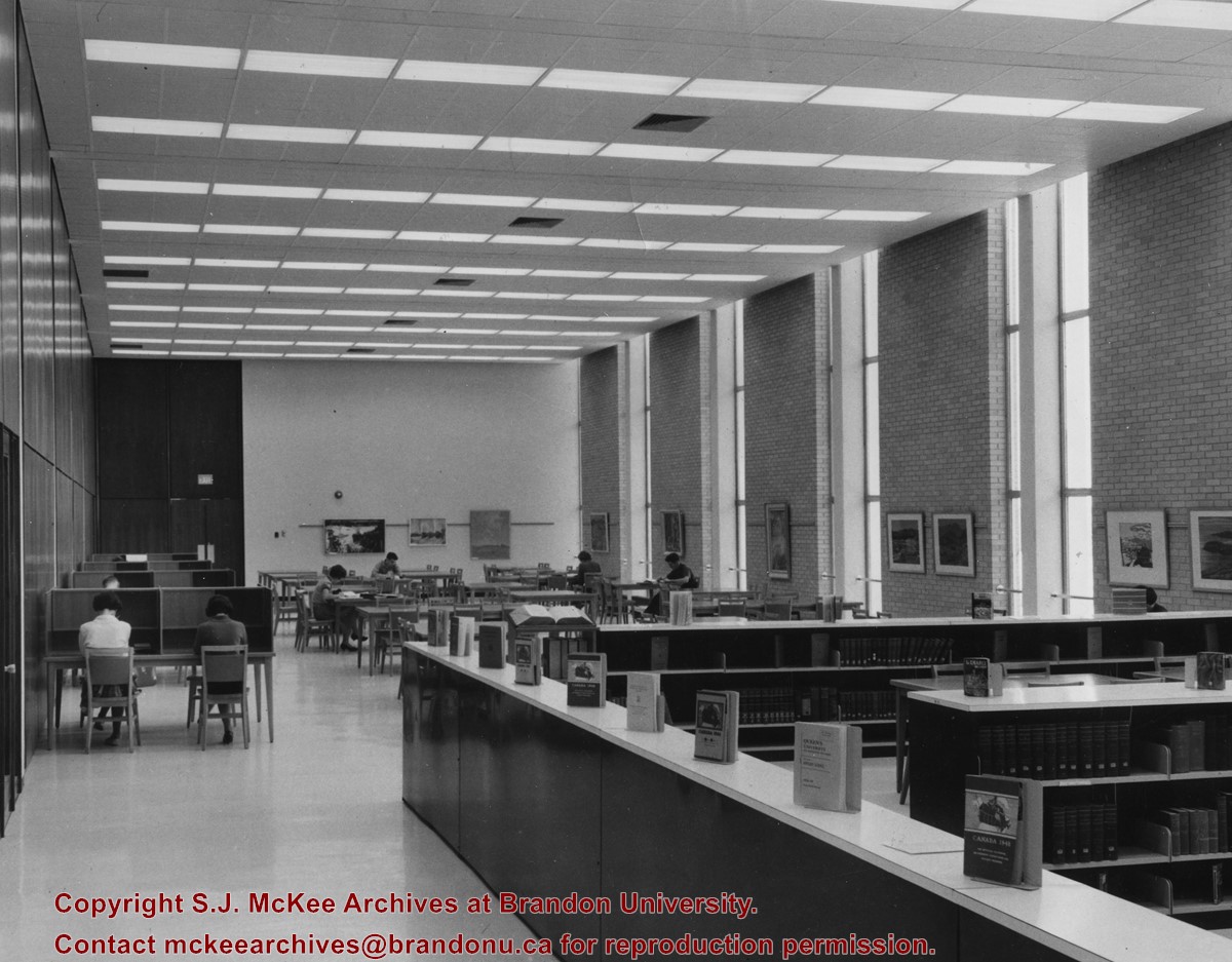
The Main Library was located in the A.E. McKenzie Building. The reading room was on the second floor in what is now the North Stacks. The Main Library was renamed the John E. Robbins Library on October 4, 1974.
Scope and Content
Photograph is looking north into the reading room of the Main Library.
Images
Show Less

Brandon College campus from the north

http://archives.brandonu.ca/en/permalink/descriptions957
Part Of
Aerial views and campus photographs
Description Level
Item
GMD
graphic
Date Range
c. 1950s
Part Of
Aerial views and campus photographs
Description Level
Item
Series Number
2.1
Item Number
2.1.39
GMD
graphic
Date Range
c. 1950s
Physical Description
4.5" x 2.75" (b/w)
Scope and Content
View is southwest. Photograph shows: Clark Hall, the Brandon College Building and the Citizens' Science Building.
Images
Show Less

British American dealers - aerial view looking southeast from intersection of Highways 1 and 10

http://archives.brandonu.ca/en/permalink/descriptions11242
Part Of
CKX fonds
Description Level
Item
GMD
graphic
Date Range
after 1954
Accession Number
11-2010
Part Of
CKX fonds
Creator
CKX
Description Level
Item
Item Number
11-2010.B3v
Accession Number
11-2010
GMD
graphic
Date Range
after 1954
Physical Description
5" x 4" (b/w)
Material Details
Negative
Custodial History
See fonds level of the CKX records for custodial history.
Scope and Content
Image consists of an aerial view looking southeast at the intersection of Highways 1 and 10 and shows the British American dealer located at the intersection.
Name Access
CKX
British American Dealers
Brandon, Manitoba
Subject Access
aerial photographs
Storage Location
CKX fonds - 2010 accessions
Images
Show Less

British American dealers - aerial view looking northeast from intersection of Highways 1 and 10

http://archives.brandonu.ca/en/permalink/descriptions11243
Part Of
CKX fonds
Description Level
Item
GMD
graphic
Date Range
after 1954
Accession Number
11-2010
Part Of
CKX fonds
Creator
CKX
Description Level
Item
Item Number
11-2010.B3w
Accession Number
11-2010
GMD
graphic
Date Range
after 1954
Physical Description
5" x 4" (b/w)
Material Details
Negative
Custodial History
See fonds level of the CKX records for custodial history.
Scope and Content
Image consists of an aerial view looking northeast at the intersection of Highways 1 and 10 and shows the British American dealer located at the intersection.
Name Access
CKX
British American Dealers
Brandon, Manitoba
Subject Access
aerial photographs
Storage Location
CKX fonds - 2010 accessions
Images
Show Less

B.C. tree fruit - Tastes good ... podner display

http://archives.brandonu.ca/en/permalink/descriptions11265
Part Of
CKX fonds
Description Level
Item
GMD
graphic
Date Range
after 1954
Accession Number
11-2010
Part Of
CKX fonds
Creator
CKX
Description Level
Item
Item Number
11-2010.B21m
Accession Number
11-2010
GMD
graphic
Date Range
after 1954
Physical Description
5" x 4" (b/w)
Material Details
Negative
Custodial History
See fonds level of the CKX records for custodial history.
Scope and Content
Image consists of a table displaying a bowl and a box of apples plus two other food items.
Name Access
CKX
Subject Access
displays
advertising
Storage Location
CKX fonds - 2010 accessions
Images
Show Less

Brandon from river bend north

http://archives.brandonu.ca/en/permalink/descriptions11499
Part Of
CKX fonds
Description Level
Item
GMD
graphic
Date Range
after 1954
Accession Number
11-2010
Part Of
CKX fonds
Creator
CKX
Description Level
Item
Item Number
11-2010.B75
Accession Number
11-2010
GMD
graphic
Date Range
after 1954
Physical Description
1.5" x 1" (b/w)
Material Details
Negative
Custodial History
See fonds level of the CKX records for custodial history.
Scope and Content
Image of Brandon viewed from a bend in the Assiniboine River north of the city.
Name Access
CKX Television
Brandon, Manitoba
Subject Access
landscapes
Landscape Photography
Storage Location
CKX fonds - 2010 accessions
Images
Show Less

Brandon streets - Rosser Avenue looking east from the 1100 block

http://archives.brandonu.ca/en/permalink/descriptions11554
Part Of
CKX fonds
Description Level
Item
GMD
graphic
Date Range
after 1954
Accession Number
11-2010
Part Of
CKX fonds
Creator
CKX
Description Level
Item
Item Number
11-2010.B103c
Accession Number
11-2010
GMD
graphic
Date Range
after 1954
Physical Description
5" x 4" (b/w)
Material Details
Negative
Custodial History
See fonds level of the CKX records for custodial history.
Scope and Content
Image of Rosser Avenue looking east from the 1100 block.
Name Access
CKX
Brandon, Manitoba
Subject Access
steetscapes
Storage Location
CKX fonds - 2010 accessions
Images
Show Less

Brandon streets - 9th Street looking north from Princess Avenue

http://archives.brandonu.ca/en/permalink/descriptions11555
Part Of
CKX fonds
Description Level
Item
GMD
graphic
Date Range
after 1954
Accession Number
11-2010
Part Of
CKX fonds
Creator
CKX
Description Level
Item
Item Number
11-2010.B103d
Accession Number
11-2010
GMD
graphic
Date Range
after 1954
Physical Description
5" x 4" (b/w)
Material Details
Negative
Custodial History
See fonds level of the CKX records for custodial history.
Scope and Content
Image of 9th Street looking north from Princess Avenue.
Name Access
CKX
Brandon, Manitoba
Subject Access
steetscapes
Storage Location
CKX fonds - 2010 accessions
Images
Show Less

Brandon streets - Princess Avenue looking east from 10th Street

http://archives.brandonu.ca/en/permalink/descriptions11556
Part Of
CKX fonds
Description Level
Item
GMD
graphic
Date Range
after 1954
Accession Number
11-2010
Part Of
CKX fonds
Creator
CKX
Description Level
Item
Item Number
11-2010.B103e
Accession Number
11-2010
GMD
graphic
Date Range
after 1954
Physical Description
5" x 4" (b/w)
Material Details
Negative
Custodial History
See fonds level of the CKX records for custodial history.
Scope and Content
Image of Princess Avenue looking east from 10th Street.
Name Access
CKX
Brandon, Manitoba
Subject Access
steetscapes
Storage Location
CKX fonds - 2010 accessions
Images
Show Less

Brandon streets - 10th Street looking north from Princess Avenue

http://archives.brandonu.ca/en/permalink/descriptions11558
Part Of
CKX fonds
Description Level
Item
GMD
graphic
Date Range
after 1954
Accession Number
11-2010
Part Of
CKX fonds
Creator
CKX
Description Level
Item
Item Number
11-2010.B103g
Accession Number
11-2010
GMD
graphic
Date Range
after 1954
Physical Description
5" x 4" (b/w)
Material Details
Negative
Custodial History
See fonds level of the CKX records for custodial history.
Scope and Content
Image of 10th Street looking north from Princess Avenue.
Name Access
CKX
Brandon, Manitoba
Subject Access
steetscapes
Storage Location
CKX fonds - 2010 accessions
Images
Show Less

Brandon streets - 10th Street looking northeast from Princess Avenue

http://archives.brandonu.ca/en/permalink/descriptions11559
Part Of
CKX fonds
Description Level
Item
GMD
graphic
Date Range
after 1954
Accession Number
11-2010
Part Of
CKX fonds
Creator
CKX
Description Level
Item
Item Number
11-2010.B103h
Accession Number
11-2010
GMD
graphic
Date Range
after 1954
Physical Description
5" x 4" (b/w)
Material Details
Negative
Custodial History
See fonds level of the CKX records for custodial history.
Scope and Content
Image of 10th Street looking northeast from Princess Avenue.
Name Access
CKX
Brandon, Manitoba
Subject Access
steetscapes
Storage Location
CKX fonds - 2010 accessions
Images
Show Less

Brandon streets - 10th Street looking south from Rosser Avenue

http://archives.brandonu.ca/en/permalink/descriptions11560
Part Of
CKX fonds
Description Level
Item
GMD
graphic
Date Range
after 1954
Accession Number
11-2010
Part Of
CKX fonds
Creator
CKX
Description Level
Item
Item Number
11-2010.B103i
Accession Number
11-2010
GMD
graphic
Date Range
after 1954
Physical Description
5" x 4" (b/w)
Material Details
Negative
Custodial History
See fonds level of the CKX records for custodial history.
Scope and Content
Image of 10th Street looking south from Rosser Avenue.
Name Access
CKX
Brandon, Manitoba
Subject Access
steetscapes
Storage Location
CKX fonds - 2010 accessions
Images
Show Less

Brandon Co-op - Young Men's Shop

http://archives.brandonu.ca/en/permalink/descriptions11686
Part Of
CKX fonds
Description Level
Item
GMD
graphic
Date Range
1967
Accession Number
11-2010
Part Of
CKX fonds
Creator
CKX
Description Level
Item
Item Number
11-2010.B135d
Accession Number
11-2010
GMD
graphic
Date Range
1967
Physical Description
1.5" x 1" (b/w)
Material Details
Negative
History / Biographical
The Brandon Co-op building is located between 6th and 7th Street on the south side of Princess Avenue. The building later housed the Brandon Public Library and Convergys.
Custodial History
See fonds level of the CKX records for custodial history.
Scope and Content
Image of the Young Men's Shop at Brandon Co-op.
Name Access
CKX Television
Brandon Co-op
Subject Access
stores
clothing
Storage Location
CKX fonds - 2010 accessions
Images
Show Less

Graham site 2005 - Bone bed from XU 4, 5 & 6

http://archives.brandonu.ca/en/permalink/descriptions11917
Part Of
RG 7 Beverley Nicholson fonds
Description Level
Item
GMD
graphic
Date Range
2005
Accession Number
1-2010
Part Of
RG 7 Beverley Nicholson fonds
Description Level
Item
Series Number
1.4.2.5
Item Number
1
Accession Number
1-2010
GMD
graphic
Date Range
2005
Physical Description
2,750 x 2,125 (1,150 KB )
Material Details
JPEG
Scope and Content
Bone bed from excavation units 4, 5 and 6
Name Access
Graham site 2005 - Bone bed from XU 4, 5 & 6
Subject Access
Archaeology Crepeele locale Graham site 2005 Graham site 2005 - photographs
Images
Show Less

Graham site 2005 - Bone bed from XU 2 & 3

http://archives.brandonu.ca/en/permalink/descriptions11919
Part Of
RG 7 Beverley Nicholson fonds
Description Level
Item
GMD
graphic
Date Range
2005
Accession Number
1-2010
Part Of
RG 7 Beverley Nicholson fonds
Description Level
Item
Series Number
1.4.2.5
Item Number
3
Accession Number
1-2010
GMD
graphic
Date Range
2005
Physical Description
2,750 x 2,063 (1,177 KB )
Material Details
JPEG
Scope and Content
Bone bed from excavation units 2 and 3 level 7.
Name Access
Graham site 2005 - Bone bed from XU 2 & 3
Subject Access
Archaeology Crepeele locale Graham site 2005 Graham site 2005 - photographs
Images
Show Less

Atkinson site 2003 - lithic tools from the site

http://archives.brandonu.ca/en/permalink/descriptions12183
Part Of
RG 7 Beverley Nicholson fonds
Description Level
Item
GMD
graphic
Date Range
2003
Accession Number
1-2010
Part Of
RG 7 Beverley Nicholson fonds
Description Level
Item
Series Number
2.1.1.5
Item Number
2.1.1.5.13
Accession Number
1-2010
GMD
graphic
Date Range
2003
Physical Description
2750 x 2125 (1,277 KB )
Material Details
JPEG
History / Biographical
Laboratory photograph of Atkinson lithic (stone) tools.
Scope and Content
Atkinson site 2003. Lithic tools from the site.
Name Access
Atkinson site 2003 - lithic tools from the site
Subject Access
Archaeology North lauder locale Atkinson site DiMe-27 Atkinson site 2003 photographs
Images
Show Less

View from the roof of the old steam plant

http://archives.brandonu.ca/en/permalink/descriptions14357
Part Of
Brandon University Photograph Collection
Description Level
Item
GMD
graphic
Date Range
November 19, 1970
Part Of
Brandon University Photograph Collection
Creator
Photographer: Tom Donkersloot
Description Level
Item
Series Number
2.12
Item Number
BUPC 2.12.26
GMD
graphic
Date Range
November 19, 1970
Physical Description
4.25" x 3.25" (b/w)
History / Biographical
Donkersloot began working at Brandon University in 1970/1971 as the Clerk of Works. From 1973 until his retirement, he was the Director of Physical Plant. The 1960s campus expansion necessitated a large, updated heat source so a central steam plant fueled by coal was built north of the campus adjacent to the CPR rail lines on Pacific Avenue. A 25-year agreement was made between the University and John R. Brodie of the Great West Coal Company, which guaranteed BU lower coal prices tendered by the Canadian National and Canadian Pacific Railways on an annual basis. Brandon College Engineer John Kasiurak officially opened the Heating Plant on 24 January 1962. An extension and/or upgrade of the steam plant appears to have occurred in 1970. Until the 1990s, heat was piped underground to the campus from the Pacific Avenue Heating Plant but inspection standards were outpacing the maintenance and repairs required to keep the plant operating smoothly. Consequently, a new steam plant was built immediately adjacent to the University to the west of Darrach Hall on 20th Street. This building was essential to handling additional loads from the proposed library expansion. The original steam plant was subsequently sold.
Custodial History
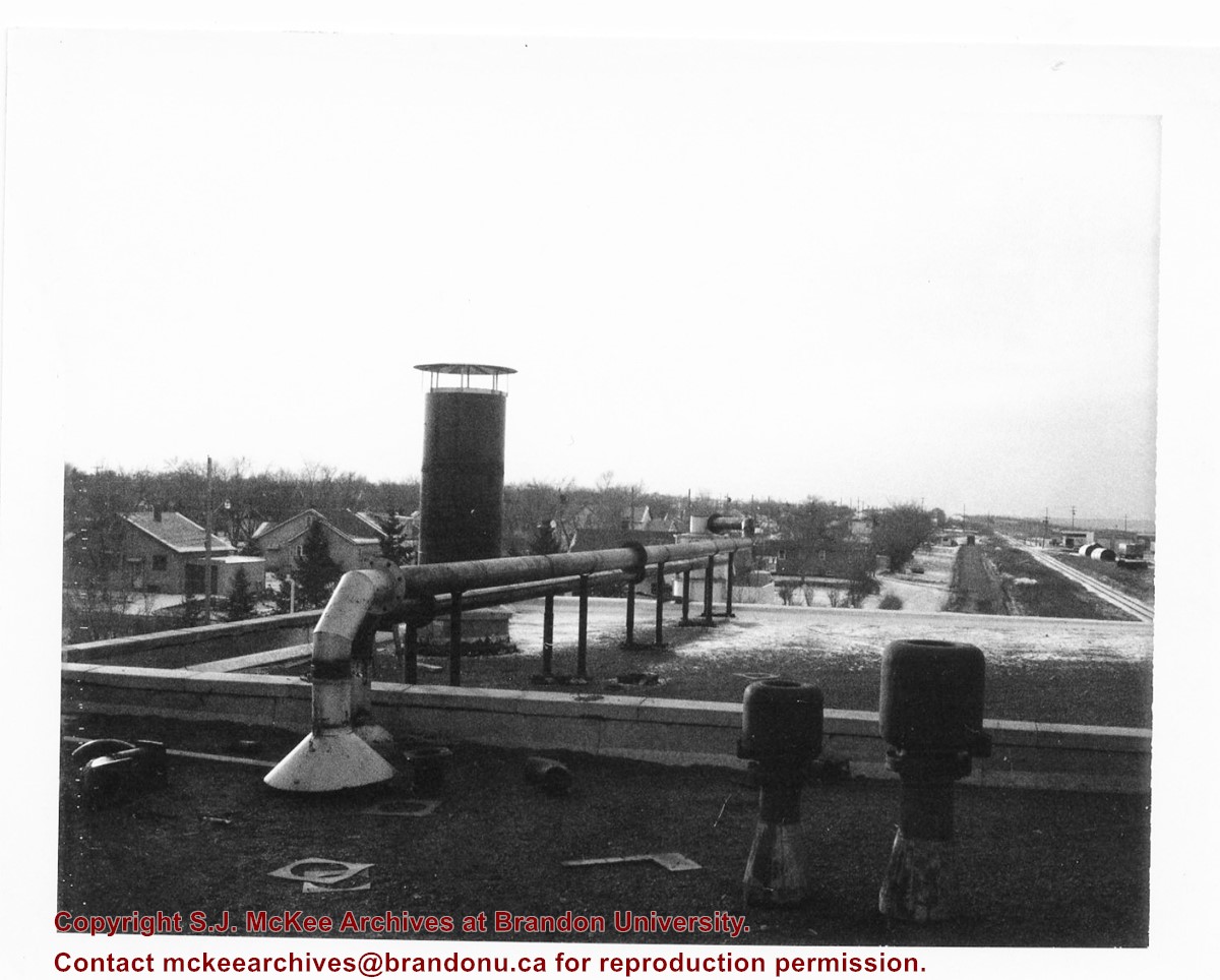
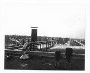
Photograph was taken by Tom Donkersloot during construction and stored in albums in the Physical Plant H-Hut until they were transfered to the McKee Archives by Doug Duncalf in May 2008.
Scope and Content
Photograph shows the roof of Brandon University's coal steam plant at 20th Street and Pacific Avenue, as well as the residential area nearby. The photograph appears to be looking west.
Notes
Donkersloot recorded the date and time each photograph was taken on the back of the photos.
Images
Show Less

Baldur, MB from south

http://archives.brandonu.ca/en/permalink/descriptions14399
Part Of
James Wall collection
Description Level
Item
GMD
graphic
Date Range
1903
Accession Number
12-2004
Part Of
James Wall collection
Description Level
Item
Series Number
Box 2
Item Number
12-2004.6
Accession Number
12-2004
GMD
graphic
Date Range
1903
Physical Description
6.75" x 4.75" (b/w)
Material Details
On matting (9" x 7")
Physical Condition
good
Custodial History
See collection level description for the James Douglas Wall collection.
Scope and Content
Image of the town of Baldur, MB. Looking south a body of water is in the foreground.
Subject Access
rural images
Storage Location
2004 accessions
Images
Show Less

20 records – page 1 of 1.