Situated in the R.M. of Whitehead on the Little Saskatchewan River, the 10 Mile Dam was a 14 kilometer transmission line that supplied the city of Brandon with power. The Brandon Electric Light Company built the dam in 1900 and it is considered Manitoba's first hydroelectic power generating station. The dam spanned approximately 80 meters and was constructed from timber and reinforced with clay and stone. The station was decommissioned in 1924.
Scope and Content
Photograph shows 10 Mile Dam, also known as the Brandon Dam or Minnedosa River Hydro Plant.
Notes
Writing on the back of the photograph reads: "10 mile dam". Biographical information obtained from Manitoba Historical Society.
Situated in the R.M. of Whitehead on the Little Saskatchewan River, the 10 Mile Dam was a 14 kilometer transmission line that supplied the city of Brandon with power. The Brandon Electric Light Company built the dam in 1900 and it is considered Manitoba's first hydroelectic power generating station. The dam spanned approximately 80 meters and was constructed from timber and reinforced with clay and stone. The station was decommissioned in 1924.
Scope and Content
Photograph shows 10 Mile Dam, also known as the Brandon Dam or Minnedosa River Hydro Plant. The dam's timber construction is quite evident in the picture.
Notes
Writing on the back of the photograph reads: McGuinness (Manitoba Hydro), on Little Saskatchewan.
Situated in the R.M. of Whitehead on the Little Saskatchewan River, the 10 Mile Dam was a 14 kilometer transmission line that supplied the city of Brandon with power. The Brandon Electric Light Company built the dam in 1900 and it is considered Manitoba's first hydroelectic power generating station. The dam spanned approximately 80 meters and was constructed from timber and reinforced with clay and stone. The station was decommissioned in 1924.
Alonzo Archibald Rowe (b. 1862, London, ON; d. 22 Oct 1951, Brandon). The Rowes were considered Brandon area pioneers. Alonzo’s father, Alonzo L. Rowe, came to Brandon with his family in 1881, where the family had a furniture and undertaker business on the west side of 10th Street between Rosser and Princess Avenues. In 1885, the family began farming west of Brandon and Alonzo Archibald served as a councilor and then a reeve in the R.M. of Whitehead. He returned to Brandon in 1907 and served with the Brandon Police Department until 1910, when he returned to farming, this time in Arrow River. A.A. Rowe returned to Brandon in 1915 to work as a Provincial Licenses Inspector, a position he held until 1938. (Source: Obituary, Brandon Daily Sun 22 Oct 1951)
Custodial History
Photograph was in possession of Mrs. Ruby Miles, who passed the image on to Fred McGuinness. McGuinness makes reference to Mrs. Miles and this photograph in his Sunbeams column (Source: F.A. Rosser, "Another interesting chat with a daughter of the plains," Brandon Sun 18 Aug 1981).
Scope and Content
Photograph shows four fishermen at 10 Mile Dam, also known as the Brandon Dam or Minnedosa River Hydro Plant. The fishermen in the photo are identified as George H. Rowe and his father A.A. Rowe, Dr. Wilfred Bigelow, and Al Collins.
Notes
Writing on the back of the photograph reads: at Brandon Dam, [right to left] son and father - George H. ROWE, Mr. A.A. ROWE, Dr. BIGELOW, Al COLLINS (dam?, 1906?, George born March 1897); Jerrett's Photo-Services, May 7 1938.
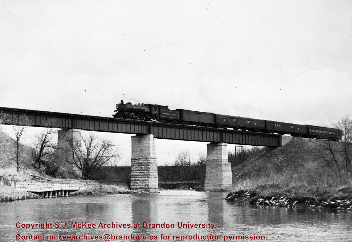
Bunclody, MB was located near Souris, MB. The bridge in question crossed the Souris River.
Custodial History
Photograph was donated by a "Mrs. Wilson" in 1989.
Scope and Content
Photograph shows a portion of the Great Northern Railway track with the Bunclody bridge in the background. Also visible are a couple of houses, railway cars, lumber and part of the Souris River. The photograph was taken in early winter or early spring.
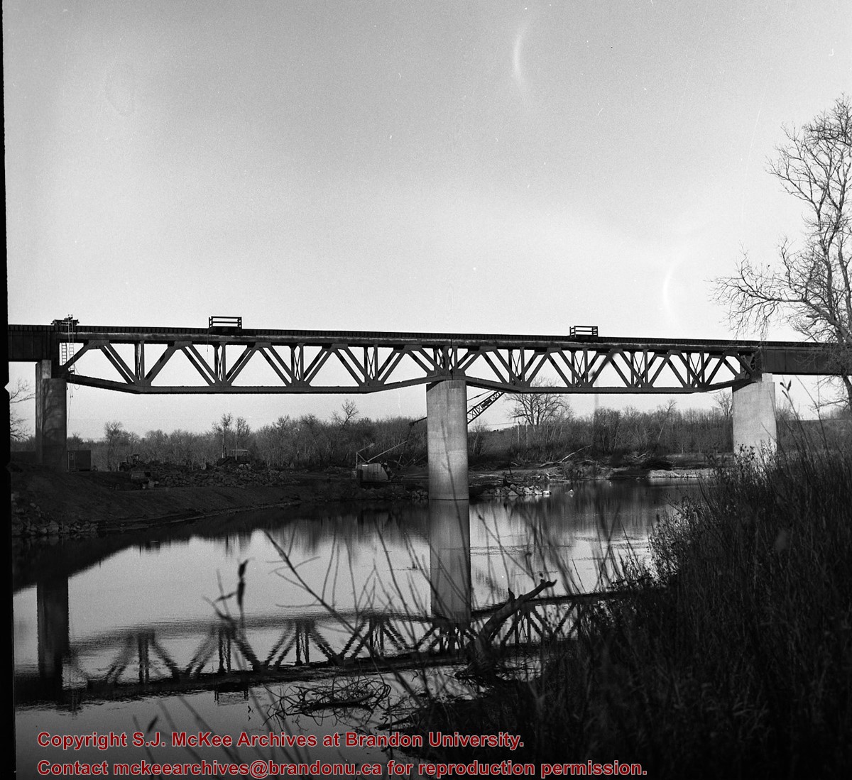
Kirkham's Bridge was built in 1906, to replace an earlier wooden bridge. The bridge was used until 1981, when it was purchased by the Town of Birtle and moved to a newsite. A former railway pridge was installed in its place.
Scope and Content
Photograph shows Kirkham's Bridge, a steel truss bridge that spanned the Little Saskatchewan River in the Municipality of Riverdale.
Notes
Identification of the bridge provided by Ken Storie (2023). Additional information taken from the Manitoba Historical Society website.
For history/bio information see the collection level description of the Lawrence Stuckey collection.
Custodial History
For custodial history see the collection level description of the Lawrence Stuckey collection.
Scope and Content
Series consists of slides created from photographs taken by Lawrence Stuckey during his travels throughout Manitoba, other parts of Canada and the United States. Although Lawrence and his wife Mavis travelled for pleasure, their destinations were often chosen deliberately to enable Lawrence to explore and photograph specific landscapes, flora and fauna.
See RG 6 Brandon University fonds, Series 7 Faculties and Schools, Sub-series 7.1 Faculty of Arts, Sub sub series 7.1.1 Dean of Arts for biographical information for Michael Blanar.
Custodial History
Collection was in the possession of Dr. Michael Blanar until he donated the records to the S.J. McKee Archives in May 2002.
Scope and Content
Collection consists of textual records and five microfilm reels related to Dr. Blanar’s post-graduate research. It is assumed that the records were collected during the course of Blanar’s research for his dissertation entitled “Early British Travellers in French Canada (1960).”
Textual records include three Dominion of Canada notebooks containing handwritten Saulteaux verbs, and animate nouns. Included is a dark red booklet titled “Ojibwe.” The book contains Ojibwa translations of English words. The book comes from St. Peter Clavers Industrial School in Spanish, Ontario, and may have acted as an instructional book as it also contains French and English. Collection also contains a transcript of an Ojibwa dictionary and three file folders titled “Manuscripts,’ “John Long Research,” and “Maps” which contain additional research material. Contents of “Manuscript” folder are original typed manuscripts. “John Long” and “Maps” file folders contain copies of materials held at Library and Archives Canada, as well as hand drawn documents and hand written documents detailing contents of folders.
In addition to the textual records there are five microfilm reels. Three microfilm cases are labeled “The British Reference Division,” one case labeled “Public Archives Canada, central microfilm operations,” and the last case is from an unidentified source labeled “Longs voyages and travels”. Four of the five microfilm cases are also numbered. The British Reference Division microfilm case numbered “1346 i 43” contains a copy of a book titled “The Cacique of Ontario.” British Reference Division microfilm case numbered “104706640” contains a copy of a book titled “The Four Kings of Canada.” British Reference Division microfilm case numbered “9073279” contains a copy of a book titled “The Indians.” The Public Archives Canada microfilm case numbered “c-3006” contains copies of original documents in French and English. Documents include letters, diary pages, maps, and business ledgers. Microfilm case labeled “Longs voyages and travels” contains a copy of a book written by John Long titled “Voyages and Travels of Indian Interpreter and Trader.”
Notes
Description by Aaron McKay (October 2013). The Ojibwa language dictionary and notebook make references to Fredric Baraga (1797-1868), a missionary priest from Slovenia who recorded the Lake Superior Ojibwa language dialect. Baraga’s findings were published into an Ojibwa language dictionary.
Postcard shows the 100 block of 10th Street facing north. The CPR train station can be seen at the end of 10th Street. The sign for the Rex Cafe is visible on the west side of 10th Street. On the east side of 10th Street, billboards for Campbell & Campbell furniture are visible as well as signs for Pianos and the Orpheum Theatre. Motorists and cyclists share the road. Street car tracks run the length of 10th Street.
Notes
Back of postcard reads: Morning reflection of Brandon's skyline on the Assiniboine River, photo by Sandy Black, printed in Brandno, Manitoba, Canada by Leech Printing Ltd.


)
)
)