Situated in the R.M. of Whitehead on the Little Saskatchewan River, the 10 Mile Dam was a 14 kilometer transmission line that supplied the city of Brandon with power. The Brandon Electric Light Company built the dam in 1900 and it is considered Manitoba's first hydroelectic power generating station. The dam spanned approximately 80 meters and was constructed from timber and reinforced with clay and stone. The station was decommissioned in 1924.
Scope and Content
Photograph shows 10 Mile Dam, also known as the Brandon Dam or Minnedosa River Hydro Plant.
Notes
Writing on the back of the photograph reads: "10 mile dam". Biographical information obtained from Manitoba Historical Society.
Situated in the R.M. of Whitehead on the Little Saskatchewan River, the 10 Mile Dam was a 14 kilometer transmission line that supplied the city of Brandon with power. The Brandon Electric Light Company built the dam in 1900 and it is considered Manitoba's first hydroelectic power generating station. The dam spanned approximately 80 meters and was constructed from timber and reinforced with clay and stone. The station was decommissioned in 1924.
Scope and Content
Photograph shows 10 Mile Dam, also known as the Brandon Dam or Minnedosa River Hydro Plant. The dam's timber construction is quite evident in the picture.
Notes
Writing on the back of the photograph reads: McGuinness (Manitoba Hydro), on Little Saskatchewan.
Situated in the R.M. of Whitehead on the Little Saskatchewan River, the 10 Mile Dam was a 14 kilometer transmission line that supplied the city of Brandon with power. The Brandon Electric Light Company built the dam in 1900 and it is considered Manitoba's first hydroelectic power generating station. The dam spanned approximately 80 meters and was constructed from timber and reinforced with clay and stone. The station was decommissioned in 1924.
Alonzo Archibald Rowe (b. 1862, London, ON; d. 22 Oct 1951, Brandon). The Rowes were considered Brandon area pioneers. Alonzo’s father, Alonzo L. Rowe, came to Brandon with his family in 1881, where the family had a furniture and undertaker business on the west side of 10th Street between Rosser and Princess Avenues. In 1885, the family began farming west of Brandon and Alonzo Archibald served as a councilor and then a reeve in the R.M. of Whitehead. He returned to Brandon in 1907 and served with the Brandon Police Department until 1910, when he returned to farming, this time in Arrow River. A.A. Rowe returned to Brandon in 1915 to work as a Provincial Licenses Inspector, a position he held until 1938. (Source: Obituary, Brandon Daily Sun 22 Oct 1951)
Custodial History
Photograph was in possession of Mrs. Ruby Miles, who passed the image on to Fred McGuinness. McGuinness makes reference to Mrs. Miles and this photograph in his Sunbeams column (Source: F.A. Rosser, "Another interesting chat with a daughter of the plains," Brandon Sun 18 Aug 1981).
Scope and Content
Photograph shows four fishermen at 10 Mile Dam, also known as the Brandon Dam or Minnedosa River Hydro Plant. The fishermen in the photo are identified as George H. Rowe and his father A.A. Rowe, Dr. Wilfred Bigelow, and Al Collins.
Notes
Writing on the back of the photograph reads: at Brandon Dam, [right to left] son and father - George H. ROWE, Mr. A.A. ROWE, Dr. BIGELOW, Al COLLINS (dam?, 1906?, George born March 1897); Jerrett's Photo-Services, May 7 1938.
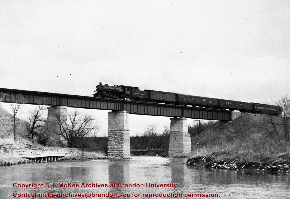
Bunclody, MB was located near Souris, MB. The bridge in question crossed the Souris River.
Custodial History
Photograph was donated by a "Mrs. Wilson" in 1989.
Scope and Content
Photograph shows a portion of the Great Northern Railway track with the Bunclody bridge in the background. Also visible are a couple of houses, railway cars, lumber and part of the Souris River. The photograph was taken in early winter or early spring.
The idea of the Keystone Centre was first mentioned in 1958, at a meeting of the board of directors of the Manitoba Winter Fair. The Manitoba Winter Fair wanted a new facility because the old Wheat City Arena had a leaking roof and a deteriorating west wall. The old facility also had limited space and the Winter Fair felt it needed more space for expansion. The Provincial Exhibition of Manitoba also had problems with their facilities, such as old barns and poor display areas. The idea of the Keystone Centre was put on hold until 1969, when the boards of the Provincial Exhibition and the Manitoba Winter Fair joined together as the Provincial Exhibition Association of Manitoba and the Wheat City Arena was sold and demolished. The original estimate for the cost of the Keystone Centre facilities was $4.5 million and funding would be proportioned so that the federal and provincial governments would each put in one-third of the money, with the rest coming from local donations. The financial campaign for the Keystone Centre began in 1970, and construction began in November 1970. The grand opening of the Centre was in March 1973, and coincided with the Royal Manitoba Winter Fair of that year.
Custodial History
This fonds was accessioned by the McKee Archives in 1998. Prior custodial history is unknown.
Scope and Content
Fonds contains many folders full of correspondence, financial statements, meeting minutes and other documents relating to the development and construction of the Keystone Centre from 1970-1974, including those from the Keystone Executive Committee, as well as the Building Committee. Fonds also contains one folder that pertains to the Brandon Area Agricultural Development Survey from 1959. This folder contains the names and locations of all farmers in the Brandon area in 1959. The Brandon Area Agricultural Development Survey was created in 1959, in order to make farming in the Brandon area more profitable. The survey was aided by Doane Agricultural Service from St. Louis, Missouri, who had success creating agricultural development programs in the United States. Fonds also contains folders from the Provincial Exhibition with correspondence, pamphlets, estimates, and studies from the 1960's. There is also one folder belonging to the Manitoba Winter Fair, which contains correspondence and financial statements relating to the Wheat City Arena. Fonds also contains information pertaining to the proposals made in the 1960's, for the building of the Keystone Centre, as well as one folder about the Keystone campaign from 1970-73. There is also one folder about the opening of the Keystone Centre, which contains newspaper clippings and guest lists. Finally, the fonds contains information about a court case involving Albert Bobyk and Robert Stewart. Stewart was the project manager for the Building Committee and Bobyk worked on the Keystone Center. The fonds includes a report about the trial of the two men who were charged with fraud involving their work on the Keystone Centre.
Kirkham's Bridge was built in 1906, to replace an earlier wooden bridge. The bridge was used until 1981, when it was purchased by the Town of Birtle and moved to a newsite. A former railway pridge was installed in its place.
Scope and Content
Photograph shows Kirkham's Bridge, a steel truss bridge that spanned the Little Saskatchewan River in the Municipality of Riverdale.
Notes
Identification of the bridge provided by Ken Storie (2023). Additional information taken from the Manitoba Historical Society website.
For history/bio information see the collection level description of the Lawrence Stuckey collection.
Custodial History
For custodial history see the collection level description of the Lawrence Stuckey collection.
Scope and Content
Series consists of slides created from photographs taken by Lawrence Stuckey during his travels throughout Manitoba, other parts of Canada and the United States. Although Lawrence and his wife Mavis travelled for pleasure, their destinations were often chosen deliberately to enable Lawrence to explore and photograph specific landscapes, flora and fauna.
The first Women's Institute in Canada was created by Mrs. Adelaide Hunter Hoodless in Stoney Creek, Ontario, on February 19, 1897. The Women's Institute was created to unite rural women with the hopes that this would help women improve their homes and communities. The motto of the Women's Institute became, "a nation could not rise above the level of its homes." The group was to be non-partisan and non-sectarian to allow for maximum participation. The Women's Institute became one of the very few ways for rural women to meet and share ideas and problems with others. The Women's Institute spread throughout Canada and reached Manitoba in 1910, when Morris and Valley River, Manitoba, formed Women's Institute branches. The Women's Institute branches in Manitoba were known as Home Economics Societies until 1919, when they became branches of the Manitoba Women's Institute. The Home Economics Societies specialized in community service work. At first, the groups concentrated on home management and child care, and eventually they became involved with social and political issues. In addition to community work, the Women's Institute branches also invited many guest speakers to their meetings and promoted education and the dissemination of information to rural women on subjects such as canning, growing fruits and vegetables, dental hygiene and rural electrification. The Manitoba Women's Institute continues its work today.
Custodial History
This fonds was accessioned in 2002 by the McKee Archives. Prior custodial history is unknown.
Scope and Content
This collection has been artificially created and consists of miscellaneous newspaper and magazine clippings, handbooks, newsletters, photos and song sheets collected by various unknown Manitoba Women's Institute branches. Some newletters included in the collection are "Institute News" from the Manitoba Women's Institute, "National Farm Forum Guide", "Federated News" from the Federated Women's Institute of Canada and "The Country Woman" from Associated Women of the World. The newspaper clippings in the collection relate to Women's Institute branches around Manitoba and the rest of Canada.
Related women's institute collections in the McKee Archives include:
Manitoba Women's Institute; Minnedosa Women's Institute; Cordova Women's Institute; Clanwilliam Women's Institute; Rathwell Women's Institute; Strathclair Women's Institute; Crocus Women's Institute; Southwest A Region - Manitoba Women's Institute; Douglas Women's Institute
Postcard shows the 100 block of 10th Street facing north. The CPR train station can be seen at the end of 10th Street. The sign for the Rex Cafe is visible on the west side of 10th Street. On the east side of 10th Street, billboards for Campbell & Campbell furniture are visible as well as signs for Pianos and the Orpheum Theatre. Motorists and cyclists share the road. Street car tracks run the length of 10th Street.
Notes
Back of postcard reads: Morning reflection of Brandon's skyline on the Assiniboine River, photo by Sandy Black, printed in Brandno, Manitoba, Canada by Leech Printing Ltd.


)
)
)