Skip header and navigation

Revise Search

31 records – page 1 of 2.

Part Of
Fred McGuinness collection
Description Level
Item
GMD
graphic
Date Range
1900-1924
Part Of
Fred McGuinness collection
Description Level
Item
Series Number
McG 9
Item Number
20-2009.26
GMD
graphic
Date Range
1900-1924
Physical Description
4.25" x 2.5" (b/w)
History / Biographical
Situated in the R.M. of Whitehead on the Little Saskatchewan River, the 10 Mile Dam was a 14 kilometer transmission line that supplied the city of Brandon with power. The Brandon Electric Light Company built the dam in 1900 and it is considered Manitoba's first hydroelectic power generating station. The dam spanned approximately 80 meters and was constructed from timber and reinforced with clay and stone. The station was decommissioned in 1924.
Scope and Content
Photograph shows 10 Mile Dam, also known as the Brandon Dam or Minnedosa River Hydro Plant.
Notes
Writing on the back of the photograph reads: "10 mile dam". Biographical information obtained from Manitoba Historical Society.
Name Access
10 Mile Dam
Ten Mile Dam
Brandon Dam
Minnedosa River Hydro Plant
Brandon Electric Light Company
Little Saskatchewan River
Subject Access
dams
Rivers
hydroelectric dams
hydroelectric generation
Storage Location
RG 5 photograph storage drawer 2 (hanging photos)
Images
Show Less
Part Of
Fred McGuinness collection
Description Level
Item
GMD
graphic
Date Range
1900-1924
Accession Number
20-2009
Part Of
Fred McGuinness collection
Description Level
Item
Series Number
McG 9
Item Number
20-2009.95
Accession Number
20-2009
GMD
graphic
Date Range
1900-1924
Physical Description
4.25" x 2.5" (b/w)
History / Biographical
Situated in the R.M. of Whitehead on the Little Saskatchewan River, the 10 Mile Dam was a 14 kilometer transmission line that supplied the city of Brandon with power. The Brandon Electric Light Company built the dam in 1900 and it is considered Manitoba's first hydroelectic power generating station. The dam spanned approximately 80 meters and was constructed from timber and reinforced with clay and stone. The station was decommissioned in 1924.
Scope and Content
Photograph shows 10 Mile Dam, also known as the Brandon Dam or Minnedosa River Hydro Plant. The dam's timber construction is quite evident in the picture.
Notes
Writing on the back of the photograph reads: McGuinness (Manitoba Hydro), on Little Saskatchewan.
Name Access
10 Mile Dam
Ten Mile Dam
Brandon Dam
Minnedosa River Hydro Plant
Brandon Electric Light Company
Little Saskatchewan River
Subject Access
dams
Rivers
hydroelectric dams
hydroelectric generation
Storage Location
RG 5 photograph storage drawer 2 (hanging photos)
Related Material
Lawrence Stuckey collection 1-2002.3.1J1
Images
Show Less

Assiniboine River; Treesbank Ferry - Stockton Ferry

http://archives.brandonu.ca/en/permalink/descriptions11023
Part Of
RG 11 Lawrence Stuckey fonds
Description Level
Item
GMD
graphic
Date Range
May 23, 1981
Part Of
RG 11 Lawrence Stuckey fonds
Creator
L.A. Stuckey
Description Level
Item
Series Number
3.3
Item Number
1-2002.3.3.BSE[362a]
GMD
graphic
Date Range
May 23, 1981
Physical Description
2.5" x 2.5"
Material Details
Negative
History / Biographical
Mr. Stuckey's notes: Jacques Wendover and Errol Bredin.
Custodial History
For custodial history see the collection level description of the Lawrence Stuckey collection.
Scope and Content
Image of Assiniboine River; Treesbank Ferry - Stockton Ferry.
Notes
[Brandon SE includes communities south of Trans-Canada #1 highway and east of PTH #10.]
Name Access
Assiniboine River
Stockton, Manitoba
Stockton Ferry
Treesbank Ferry
Jacques Wendover
Errol Bredin
Subject Access
ferries
Transportation
water transportation
ferry services
Rivers
Storage Location
Lawrence Stuckey collection
Arrangement
[Mr. Stuckey put four negatives in the same envelope. We have separated them and numbered the negatives (362a) to (362d)].
Images
Show Less

Assiniboine River; Treesbank Ferry - Stockton Ferry

http://archives.brandonu.ca/en/permalink/descriptions11024
Part Of
RG 11 Lawrence Stuckey fonds
Description Level
Item
GMD
graphic
Date Range
May 23, 1981
Part Of
RG 11 Lawrence Stuckey fonds
Creator
L.A. Stuckey
Description Level
Item
Series Number
3.3
Item Number
1-2002.3.3.BSE[362b]
GMD
graphic
Date Range
May 23, 1981
Physical Description
2.5" x 2.5"
Material Details
Negative
History / Biographical
Mr. Stuckey's notes: Jacques Wendover and Errol Bredin.
Custodial History
For custodial history see the collection level description of the Lawrence Stuckey collection.
Scope and Content
Image of Assiniboine River; Treesbank Ferry - Stockton Ferry.
Notes
[Brandon SE includes communities south of Trans-Canada #1 highway and east of PTH #10.]
Name Access
Assiniboine River
Stockton, Manitoba
Stockton Ferry
Treesbank Ferry
Jacques Wendover
Errol Bredin
Subject Access
ferries
Transportation
water transportation
ferry services
Rivers
Storage Location
Lawrence Stuckey collection
Arrangement
[Mr. Stuckey put four negatives in the same envelope. We have separated them and numbered the negatives (362a) to (362d)].
Images
Show Less

Assiniboine River; Treesbank Ferry - Stockton Ferry

http://archives.brandonu.ca/en/permalink/descriptions11025
Part Of
RG 11 Lawrence Stuckey fonds
Description Level
Item
GMD
graphic
Date Range
May 23, 1981
Part Of
RG 11 Lawrence Stuckey fonds
Creator
L.A. Stuckey
Description Level
Item
Series Number
3.3
Item Number
1-2002.3.3.BSE[362c]
GMD
graphic
Date Range
May 23, 1981
Physical Description
2.5" x 2.5"
Material Details
Negative
History / Biographical
Mr. Stuckey's notes: Jacques Wendover and Errol Bredin.
Custodial History
For custodial history see the collection level description of the Lawrence Stuckey collection.
Scope and Content
Image of Assiniboine River; Treesbank Ferry - Stockton Ferry.
Notes
[Brandon SE includes communities south of Trans-Canada #1 highway and east of PTH #10.]
Name Access
Assiniboine River
Stockton, Manitoba
Stockton Ferry
Treesbank Ferry
Jacques Wendover
Errol Bredin
Subject Access
ferries
Transportation
water transportation
ferry services
Rivers
Storage Location
Lawrence Stuckey collection
Arrangement
[Mr. Stuckey put four negatives in the same envelope. We have separated them and numbered the negatives (362a) to (362d)].
Images
Show Less

Assiniboine River; Treesbank Ferry - Stockton Ferry

http://archives.brandonu.ca/en/permalink/descriptions11026
Part Of
RG 11 Lawrence Stuckey fonds
Description Level
Item
GMD
graphic
Date Range
May 23, 1981
Part Of
RG 11 Lawrence Stuckey fonds
Creator
L.A. Stuckey
Description Level
Item
Series Number
3.3
Item Number
1-2002.3.3.BSE[362d]
GMD
graphic
Date Range
May 23, 1981
Physical Description
2.5" x 2.5"
Material Details
Negative
History / Biographical
Mr. Stuckey's notes: Jacques Wendover and Errol Bredin.
Custodial History
For custodial history see the collection level description of the Lawrence Stuckey collection.
Scope and Content
Image of Assiniboine River; Treesbank Ferry - Stockton Ferry.
Notes
[Brandon SE includes communities south of Trans-Canada #1 highway and east of PTH #10.]
Name Access
Assiniboine River
Stockton, Manitoba
Stockton Ferry
Treesbank Ferry
Jacques Wendover
Errol Bredin
Subject Access
ferries
Transportation
water transportation
ferry services
Rivers
Storage Location
Lawrence Stuckey collection
Arrangement
[Mr. Stuckey put four negatives in the same envelope. We have separated them and numbered the negatives (362a) to (362d)].
Images
Show Less

CPR no. 55 Engine 1210 on Souris River bridge, Treesbank, Manitoba

http://archives.brandonu.ca/en/permalink/descriptions10405
Part Of
RG 11 Lawrence Stuckey fonds
Description Level
Item
GMD
graphic
Date Range
April 22, 1954
Accession Number
1-2002
Part Of
RG 11 Lawrence Stuckey fonds
Creator
L.A. Stuckey
Description Level
Item
Series Number
3.3
Item Number
1-2002.3.3.CPR[58]
Accession Number
1-2002
GMD
graphic
Date Range
April 22, 1954
Physical Description
5" x 3.5" (b/w)
Material Details
Copy negative
History / Biographical
Stuckey's notes: 1210, 4-6-2- class G-5B. Built at Montreal Locomotive Works 1945.
Custodial History
For custodial history see the collection level description of the Lawrence Stuckey collection.
Scope and Content
Image of CPR no. 55 engine 1210 on Souris River bridge, Treesbank, Manitoba, taken along the CPR lines south of mainline.
Name Access
CPR
Treesbank, Manitoba
Souris River
Subject Access
railways
trains
locomotives
bridges
Rivers
geographic features
Repro Restriction
The McKee Archives is the copyright holder of the Stuckey materials.
Storage Location
Lawrence Stuckey collection
Images
Show Less

Curries Landing (Assiniboine River)

http://archives.brandonu.ca/en/permalink/descriptions11132
Part Of
RG 11 Lawrence Stuckey fonds
Description Level
Item
GMD
graphic
Date Range
Apr. 12, 1977
Part Of
RG 11 Lawrence Stuckey fonds
Creator
L.A. Stuckey
Description Level
Item
Series Number
3.3
Item Number
1-2002.3.3.BSE[366a]
GMD
graphic
Date Range
Apr. 12, 1977
Physical Description
2.5" x 2.5"
Material Details
Negative
Custodial History
For custodial history see the collection level description of the Lawrence Stuckey collection.
Scope and Content
Image of Curries Landing (Assiniboine River).
Notes
[Brandon SE includes communities south of Trans-Canada #1 highway and east of PTH #10.]
Name Access
Curries Landing
Assiniboine River
Subject Access
Rivers
Storage Location
Lawrence Stuckey collection
Arrangement
[Mr. Stuckey put three negatives in the same envelope. We have separated them and numbered the negatives (366a) to(366c)].
Images
Show Less

Curries Landing (Assiniboine River)

http://archives.brandonu.ca/en/permalink/descriptions11134
Part Of
RG 11 Lawrence Stuckey fonds
Description Level
Item
GMD
graphic
Date Range
Apr. 12, 1977
Part Of
RG 11 Lawrence Stuckey fonds
Creator
L.A. Stuckey
Description Level
Item
Series Number
3.3
Item Number
1-2002.3.3.BSE[366b]
GMD
graphic
Date Range
Apr. 12, 1977
Physical Description
2.5" x 2.5"
Material Details
Negative
Custodial History
For custodial history see the collection level description of the Lawrence Stuckey collection.
Scope and Content
Image of Curries Landing (Assiniboine River).
Notes
[Brandon SE includes communities south of Trans-Canada #1 highway and east of PTH #10.]
Name Access
Curries Landing
Assiniboine River
Subject Access
Rivers
Storage Location
Lawrence Stuckey collection
Arrangement
[Mr. Stuckey put three negatives in the same envelope. We have separated them and numbered the negatives (366a) to(366c)].
Images
Show Less

Curries Landing (Assiniboine River)

http://archives.brandonu.ca/en/permalink/descriptions11135
Part Of
RG 11 Lawrence Stuckey fonds
Description Level
Item
GMD
graphic
Date Range
Apr. 12, 1977
Part Of
RG 11 Lawrence Stuckey fonds
Creator
L.A. Stuckey
Description Level
Item
Series Number
3.3
Item Number
1-2002.3.3.BSE[366c]
GMD
graphic
Date Range
Apr. 12, 1977
Physical Description
2.5" x 2.5"
Material Details
Negative
Custodial History
For custodial history see the collection level description of the Lawrence Stuckey collection.
Scope and Content
Image of Curries Landing (Assiniboine River).
Notes
[Brandon SE includes communities south of Trans-Canada #1 highway and east of PTH #10.]
Name Access
Curries Landing
Assiniboine River
Subject Access
Rivers
Storage Location
Lawrence Stuckey collection
Arrangement
[Mr. Stuckey put three negatives in the same envelope. We have separated them and numbered the negatives (366a) to(366c)].
Images
Show Less

Fishing at 10 Mile Dam

http://archives.brandonu.ca/en/permalink/descriptions13731
Part Of
Fred McGuinness collection
Description Level
Item
GMD
graphic
Date Range
1906?
Accession Number
20-2009
Part Of
Fred McGuinness collection
Description Level
Item
Series Number
McG 9
Item Number
20-2009.41
Accession Number
20-2009
GMD
graphic
Date Range
1906?
Physical Description
6.5" x 4.75" (b/w)
Material Details
reproduction
History / Biographical
Situated in the R.M. of Whitehead on the Little Saskatchewan River, the 10 Mile Dam was a 14 kilometer transmission line that supplied the city of Brandon with power. The Brandon Electric Light Company built the dam in 1900 and it is considered Manitoba's first hydroelectic power generating station. The dam spanned approximately 80 meters and was constructed from timber and reinforced with clay and stone. The station was decommissioned in 1924. Alonzo Archibald Rowe (b. 1862, London, ON; d. 22 Oct 1951, Brandon). The Rowes were considered Brandon area pioneers. Alonzo’s father, Alonzo L. Rowe, came to Brandon with his family in 1881, where the family had a furniture and undertaker business on the west side of 10th Street between Rosser and Princess Avenues. In 1885, the family began farming west of Brandon and Alonzo Archibald served as a councilor and then a reeve in the R.M. of Whitehead. He returned to Brandon in 1907 and served with the Brandon Police Department until 1910, when he returned to farming, this time in Arrow River. A.A. Rowe returned to Brandon in 1915 to work as a Provincial Licenses Inspector, a position he held until 1938. (Source: Obituary, Brandon Daily Sun 22 Oct 1951)
Custodial History
Photograph was in possession of Mrs. Ruby Miles, who passed the image on to Fred McGuinness. McGuinness makes reference to Mrs. Miles and this photograph in his Sunbeams column (Source: F.A. Rosser, "Another interesting chat with a daughter of the plains," Brandon Sun 18 Aug 1981).
Scope and Content
Photograph shows four fishermen at 10 Mile Dam, also known as the Brandon Dam or Minnedosa River Hydro Plant. The fishermen in the photo are identified as George H. Rowe and his father A.A. Rowe, Dr. Wilfred Bigelow, and Al Collins.
Notes
Writing on the back of the photograph reads: at Brandon Dam, [right to left] son and father - George H. ROWE, Mr. A.A. ROWE, Dr. BIGELOW, Al COLLINS (dam?, 1906?, George born March 1897); Jerrett's Photo-Services, May 7 1938.
Name Access
10 Mile Dam
Ten Mile Dam
Brandon Dam
Minnedosa River Hydro Plant
Brandon Electric Light Company
Little Saskatchewan River
George H. Rowe
A.A. Rowe
Dr. Bigelow
Al Collins
Subject Access
dams
Rivers
fishing
Storage Location
RG 5 photograph storage drawer 2 (hanging photos)
Related Material
Ruby Miles collection 14-2003
Images
Show Less

Great Northern Railway construction

http://archives.brandonu.ca/en/permalink/descriptions10150
Part Of
RG 12 Brandon and Area Photograph Collection
Description Level
Item
GMD
graphic
Date Range
[19--]
Part Of
RG 12 Brandon and Area Photograph Collection
Description Level
Item
Series Number
3
Item Number
BAPC 3.4
GMD
graphic
Date Range
[19--]
Physical Description
5.5" x 3.25" (b/w)
History / Biographical
Bunclody, MB was located near Souris, MB. The bridge in question crossed the Souris River.
Custodial History
Photograph was donated by a "Mrs. Wilson" in 1989.
Scope and Content
Photograph shows the Great Northern Railway bridge or trestle at Bunclody, MB in winter.
Name Access
Great Northern Railway
Bunclody, MB
Souris River
Subject Access
rail transportation
bridges
Rivers
manmade geographic features
construction of railroads
Storage Location
BAPC photograph drawer
Images
Show Less

Great Northern Railway construction

http://archives.brandonu.ca/en/permalink/descriptions10151
Part Of
RG 12 Brandon and Area Photograph Collection
Description Level
Item
GMD
graphic
Date Range
[19--]
Part Of
RG 12 Brandon and Area Photograph Collection
Description Level
Item
Series Number
3
Item Number
BAPC 3.5
GMD
graphic
Date Range
[19--]
Physical Description
5.5" x 3.25" (b/w)
History / Biographical
Bunclody, MB was located near Souris, MB. The bridge in question crossed the Souris River.
Custodial History
Photograph was donated by a "Mrs. Wilson" in 1989.
Scope and Content
Photograph shows the Great Northern Railway bridge or trestle at Bunclody, MB in spring or fall.
Name Access
Great Northern Railway
Bunclody, MB
Souris River
Subject Access
rail transportation
bridges
Rivers
manmade geographic features
Storage Location
BAPC photograph drawer
Images
Show Less

Great Northern Railway near Bunclody, MB

http://archives.brandonu.ca/en/permalink/descriptions10152
Part Of
RG 12 Brandon and Area Photograph Collection
Description Level
Item
GMD
graphic
Date Range
[19--]
Part Of
RG 12 Brandon and Area Photograph Collection
Description Level
Item
Series Number
3
Item Number
BAPC 3.6
GMD
graphic
Date Range
[19--]
Physical Description
5.5" x 3.25" (b/w)
History / Biographical
Bunclody, MB was located near Souris, MB. The bridge in question crossed the Souris River.
Custodial History
Photograph was donated by a "Mrs. Wilson" in 1989.
Scope and Content
Photograph shows a portion of the Great Northern Railway track with the Bunclody bridge in the background. Also visible are a couple of houses, railway cars, lumber and part of the Souris River. The photograph was taken in early winter or early spring.
Name Access
Great Northern Railway
Bunclody, MB
Souris River
Subject Access
rail transportation
bridges
Rivers
manmade geographic features
Storage Location
BAPC photograph drawer
Images
Show Less

J.C. Cousins fonds

http://archives.brandonu.ca/en/permalink/descriptions5137
Part Of
RG 5 Western Manitoba Manuscript Collection
Description Level
Collection
GMD
multiple media
Date Range
pre-1881settlement era - 1940s
Accession Number
26-2007
Part Of
RG 5 Western Manitoba Manuscript Collection
Description Level
Collection
Accession Number
26-2007
GMD
multiple media
Date Range
pre-1881settlement era - 1940s
Physical Description
6 cm
Physical Condition
Generally good, but tattered in some places.
History / Biographical
John C. Cousins was the son of Thomas Cousins (b. August 17, 1882 in Truro, Nova Scotia - d. March 5, 1914) and Mary Margaret Craig (b. April 14, 1824 - d. April 25, 1903). He married Eunice Eliza Nixon from London Township, County of Middlesex, Ontario. Together they had three children: Eunice M., Eric O. and Kathleen. J.C. Cousins was Reeve of the Rural Municipality of Daly from 1905 to 1910 and Assessor for the Town of Rivers from 1931-1938.
Custodial History
Record was accessioned in 2007 by the McKee Archives. Prior custodial history unknown.
Scope and Content
This document is a rambling memoir of John C. Cousins' recollections of life in the Rural Municipality of Daly from the settlement era in the early 1880s, through to the 1940s. He touches on various themes, including: his family history; the activities of the R.M. of Daly and his role as Reeve; the history of school districts in the municipality (lists names of first teachers and early students); the history of churches in the municipality; tragedies in the municipality; lists members of the Council of the municipality for the years 1885-1946; and the devastating impact of the Spanish Influenza on Aboriginal people in the municipality. In addition, the memoir includes documentary records, such as minutes and copies of letters. There are also many photographs of both events and individuals (virtually all of the photographs are labelled and names are provided). The memoir goes beyond a simple recounting of facts. Cousins is discursive and thoughtful, often making references to developments happening in other parts of North America and Canada. There is also a link to the Maritimes, from which his family originated.
Notes
Description by Christy Henry and Tom Mitchell.
Subject Access
Pendennis
Rivers
Manitoba
Harrow school
Mayne School Distritct
Hunter School District No. 571
Poplar Hill school
Tarbolton School District
Wheatland School District
Westwood School District
Bradwardine School District
Ancrum or Wellwood School District
Spring Valley School District
Aetna School District
Robinville School District
Oakleigh school
Lothian School District
Rivers School District
Storage Location
2007 accessions
Storage Range
2007 accessions
Show Less
Part Of
Fred McGuinness collection
Description Level
Item
GMD
graphic
Date Range
[19--]
Accession Number
20-2009
Other Title Info
Formerly called "bridge over Souris River?"
Part Of
Fred McGuinness collection
Description Level
Item
Series Number
McG 9
Item Number
20-2009.100
Accession Number
20-2009
GMD
graphic
Date Range
[19--]
Physical Description
10" x 8" (b/w)
History / Biographical
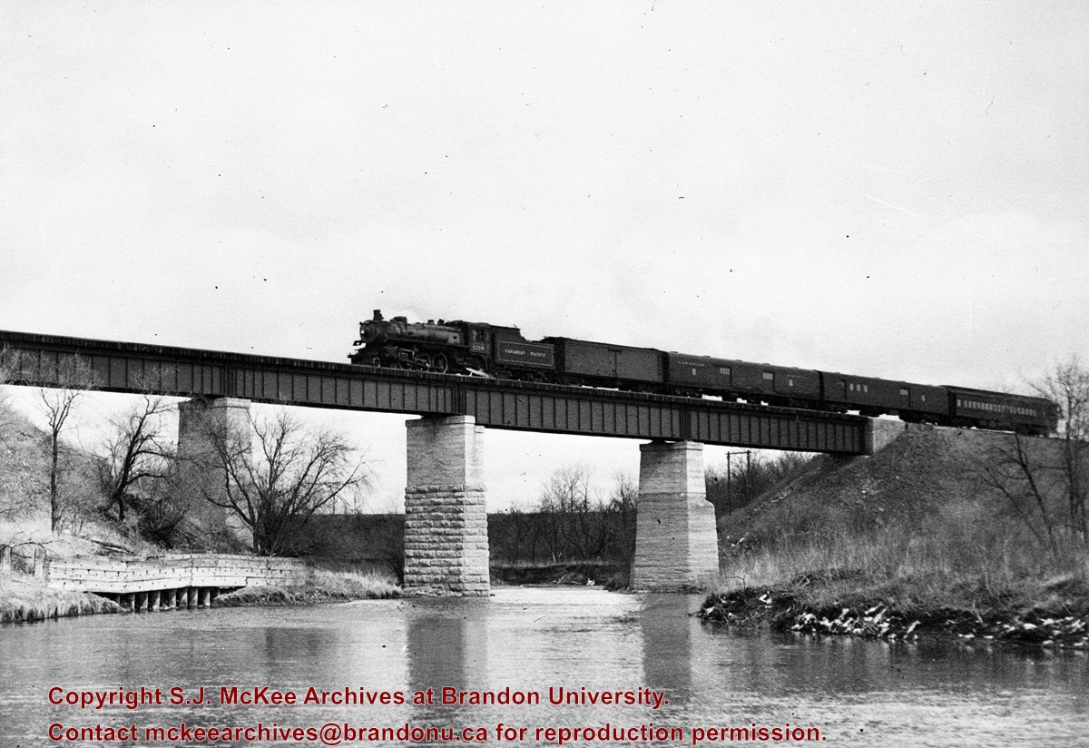
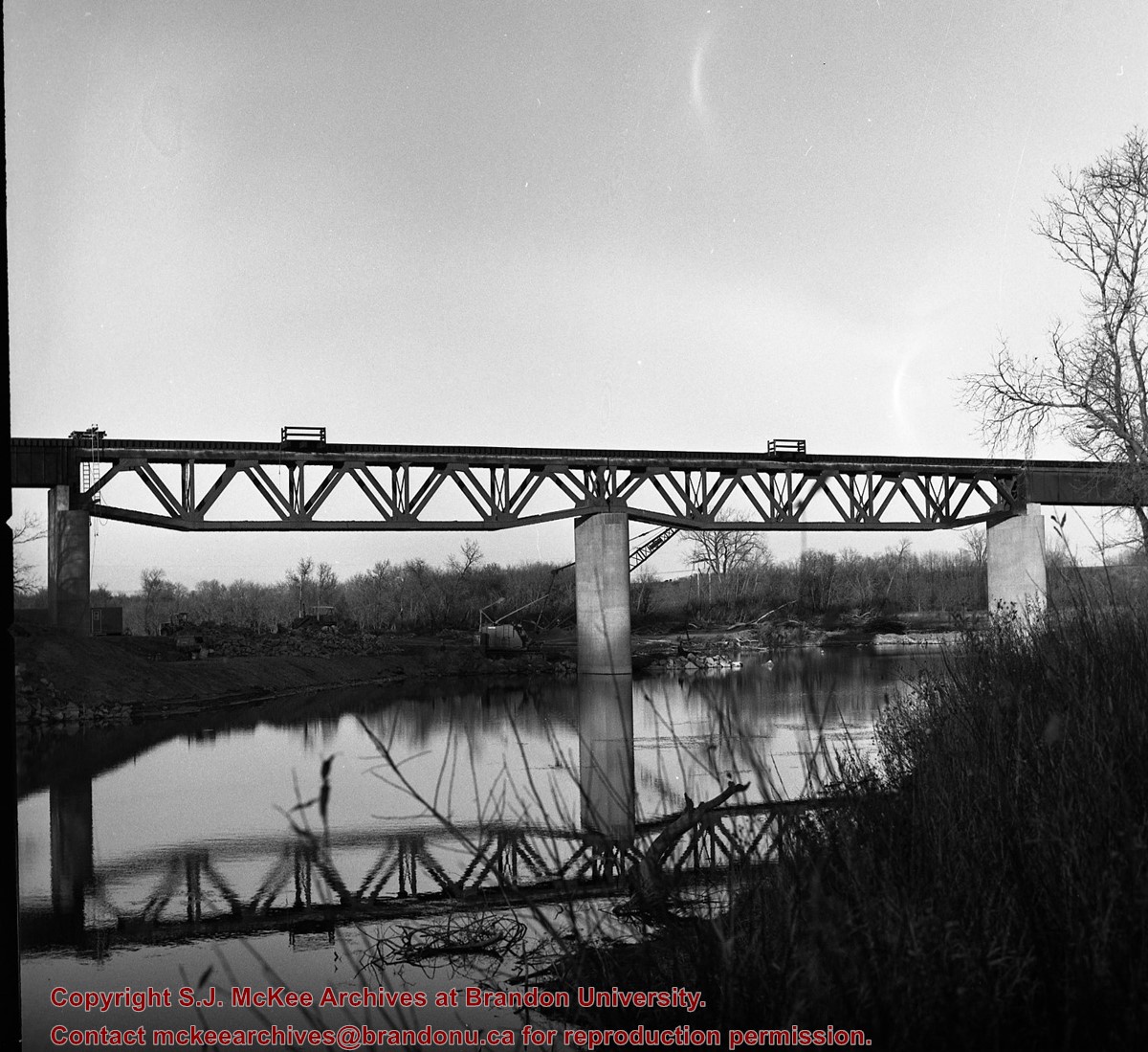
Kirkham's Bridge was built in 1906, to replace an earlier wooden bridge. The bridge was used until 1981, when it was purchased by the Town of Birtle and moved to a newsite. A former railway pridge was installed in its place.
Scope and Content
Photograph shows Kirkham's Bridge, a steel truss bridge that spanned the Little Saskatchewan River in the Municipality of Riverdale.
Notes
Identification of the bridge provided by Ken Storie (2023). Additional information taken from the Manitoba Historical Society website.
Subject Access
bridges
Rivers
Storage Location
RG 5 photograph storage drawer 2 (hanging photos)
Images
Show Less

Lawrence Stuckey slide collection

http://archives.brandonu.ca/en/permalink/descriptions9512
Part Of
RG 11 Lawrence Stuckey fonds
Description Level
Series
GMD
graphic
Date Range
1954-1982
Accession Number
1-2002
Part Of
RG 11 Lawrence Stuckey fonds
Description Level
Series
Series Number
2
Accession Number
1-2002
GMD
graphic
Date Range
1954-1982
Physical Description
approximately 3838 colour slides
History / Biographical
For history/bio information see the collection level description of the Lawrence Stuckey collection.
Custodial History
For custodial history see the collection level description of the Lawrence Stuckey collection.
Scope and Content
Series consists of slides created from photographs taken by Lawrence Stuckey during his travels throughout Manitoba, other parts of Canada and the United States. Although Lawrence and his wife Mavis travelled for pleasure, their destinations were often chosen deliberately to enable Lawrence to explore and photograph specific landscapes, flora and fauna.
Name Access
Glendenning
Assiniboine River
Souris River
Sidney
Manitoba
Whiteshell
Carberry Hills
Baldhead Hills
Sprucewoods
Duck Mountains
Rossburn
Thompson
Kelsey Trail
E.T. Seton Park
Steeprock Bay
Steeprock River
Flin Flon
Rocky Lake
Lake Winnipegosis
Turtle Mountains
Riding Mountain National Park
Moon Lake
Lake Katherine
Clear Lake
Arrowhead Trail
B&B Trail
Ominik Trail
Gorge Creek
Scarborough
Ontario
Edwards Gardens
Royal Botanical Gardens
Prince Albert
Saskatoon
Lake Madge
Winnipeg
Saskatchewan
International Peace Gardens
South Dakota
Black Hills
North Dakota
Quebec
Kenora
Qu'Appelle Valley
Theodore Roosevelt National Monument
Toronto
Point Pelee
Port Dover
Windsor
Yellowstone National Park
Wyoming
Ottawa
Scotsbluff
Nebraska
Mt. Evans Road
Colorado
Berthoud Pass
Milner Pass
Dinosaur Park
Trail Ridge
Rollins Pass
Grand Teton
Beartooth Pass
Craters of the Moon
Idaho
Medicine Bow National Fort
Michigan
Wisconsin
Quebec City
Mont. Tremblant Park
Sugar Camp
Satine-Anne-de-Bellevue Canal
Montreal
Banff National Park
Larch Valley
Sentinel Pass
Lake Louise
Moraine Lake
Athabaska River
Plain of Six
Columbia Icefields
Bow River
Victoria Glacier
Yoho Pass
Yoho National Park
Wapta Falls
Hoodoo Park
Waterfall Valley
Highline Trail
Burgess Pass
Takakaw Falls
Kicking Horse
Skyline Trail
Waterton Lakes National Park
Emerald Lake
Yoho Valley
Twin Falls Creek
Trans Canada Highway
Subject Access
geographic features
manmade geographic features
natural geographic features
political geographic features
natural phenomena
natural waterways
bridges
canals
mines
roads
trails
monuments
historical markers
lakes
mountains
national parks
parks
hills
valleys
Rivers
cities
towns
landscapes
creeks
gardens
Plants
trees
badlands
glaciers
icefields
hoodoos
waterfalls
beaches
forests
Accruals
Additional slides of flora and fauna taken by Stuckey during his travels are housed in the McKee Archives. Those slides are unprocessed at present.
Repro Restriction
The McKee Archives is the copyright holder for the Stuckey materials.
Storage Location
Lawrence Stuckey collection
Show Less

Morning reflection of Brandon's skyline on the Assiniboine River

http://archives.brandonu.ca/en/permalink/descriptions13781
Part Of
Fred McGuinness collection
Description Level
Item
GMD
graphic
Date Range
[1980s]
Accession Number
20-2009
Part Of
Fred McGuinness collection
Creator
Photographer: Sandy Black
Description Level
Item
Series Number
McG 9
Item Number
20-2009.92
Accession Number
20-2009
GMD
graphic
Date Range
[1980s]
Physical Description
5.5" x 3.5" (colour)
Material Details
postcard
Scope and Content
Postcard shows the 100 block of 10th Street facing north. The CPR train station can be seen at the end of 10th Street. The sign for the Rex Cafe is visible on the west side of 10th Street. On the east side of 10th Street, billboards for Campbell & Campbell furniture are visible as well as signs for Pianos and the Orpheum Theatre. Motorists and cyclists share the road. Street car tracks run the length of 10th Street.
Notes
Back of postcard reads: Morning reflection of Brandon's skyline on the Assiniboine River, photo by Sandy Black, printed in Brandno, Manitoba, Canada by Leech Printing Ltd.
Name Access
Assiniboine River
McKenzie Seeds
Scotia Towers
Subject Access
Rivers
downtown
Storage Location
RG 5 photograph storage drawer 2 (hanging photos)
Images
Show Less

New CPR bridge over Souris River, east of Treesbank, Manitoba

http://archives.brandonu.ca/en/permalink/descriptions10407
Part Of
RG 11 Lawrence Stuckey fonds
Description Level
Item
GMD
graphic
Date Range
October 22, 1978
Accession Number
1-2002
Part Of
RG 11 Lawrence Stuckey fonds
Creator
L.A. Stuckey
Description Level
Item
Series Number
3.3
Item Number
1-2002.3.3.CPR[59a]
Accession Number
1-2002
GMD
graphic
Date Range
October 22, 1978
Physical Description
2.25" x 2.25 (b/w)
Material Details
Negative
Custodial History
For custodial history see the collection level description of the Lawrence Stuckey collection.
Scope and Content
Image of CPR bridge over Souris River, east of Treesbank, Manitoba, taken along the CPR lines south of mainline.
Name Access
CPR
Treesbank, Manitoba
Souris River
Subject Access
railways
bridges
Rivers
geographic features
Repro Restriction
The McKee Archives is the copyright holder of the Stuckey materials.
Storage Location
Lawrence Stuckey collection
Arrangement
[Mr. Stuckey put two negatives in same envelope. We have separated them and numbered them (59a) and (59b)].
Images
Show Less

New CPR bridge over Souris River, east of Treesbank, Manitoba

http://archives.brandonu.ca/en/permalink/descriptions10408
Part Of
RG 11 Lawrence Stuckey fonds
Description Level
Item
GMD
graphic
Date Range
October 22, 1978
Accession Number
1-2002
Part Of
RG 11 Lawrence Stuckey fonds
Creator
L.A. Stuckey
Description Level
Item
Series Number
3.3
Item Number
1-2002.3.3.CPR[59b]
Accession Number
1-2002
GMD
graphic
Date Range
October 22, 1978
Physical Description
2.25" x 2.25 (b/w)
Material Details
Negative
Custodial History
For custodial history see the collection level description of the Lawrence Stuckey collection.
Scope and Content
Image of CPR bridge over Souris River, east of Treesbank, Manitoba, taken along the CPR lines south of mainline.
Name Access
CPR
Treesbank, Manitoba
Souris River
Subject Access
railways
bridges
Rivers
geographic features
Repro Restriction
The McKee Archives is the copyright holder of the Stuckey materials.
Storage Location
Lawrence Stuckey collection
Arrangement
[Mr. Stuckey put two negatives in same envelope. We have separated them and numbered them (59a) and (59b)].
Images
Show Less

31 records – page 1 of 2.