Postcard shows an aerial view of 9th Street facing south in Brandon, Manitoba. Visible businesses and landmarks include: Beaubier Hotel, YMCA/police station, the original CKX Radio station towers on 8th Street (est. 1928 - moved 1940), the old City Hall, Prince Edward Hotel, and the original Manitoba Power commission smokestack on 10th Street.
Notes
Writing on the front of the photograph reads: Brandon, Man., Jerrett Photo. This photograph shows a rare view of the 800-block between Rosser and Princess Avenues.
Photograph shows seven men posing in front of a wood-framed shack on 10th Street. The men are wearing three-piece suits or vests and long-sleeved shirts. One man can be seen holding an axe another a saw. A double ox-team wagon is in front of the structure.
Notes
Writing on the back of the photograph reads: 10th St. May 1882, Brandon. Photograph is stamped Public Archives Canada.
Photograph of 10th Street facing north from Princess Avenue. Vehicles are parallel parked on both sides of the street. The Welcome Brandon sign can be seen at the Rosser Avenue intersection.
Visible businesses on the west side of 10th Street include: Doig's, Box Brothers Hardware and Allied Hardware Stores in the Alexandra Block; followed by Simpsons-Sears in the Strathcona Block. Barry Neill Men's Wear, Kresge's and the Cecil Hotel are also visible. The Johnny Smith Block is visible in the background.
Visible businesses on the east side of 10th Street include: Ollies Steaks and Chops, Elna Sewing Centre, Carlton Cafe, Chop Suey. At the base of the hill the Canadian Pacific train station is visible at the base of the hill.
Notes
Writing on the front of the postcard reads: Tenth St. Brandon, Man.
Photograph shows a street view of 10th Street facing north. There are many automobiles parked along the street and several pedestrians in summer dress are on the sidewalks and street. Visible business signs include: Hentzman & Co. Pianos (possibly belonging to J.J.H. McLean Co. Ltd.), the Strand Theatre, T & D Clothes, Campbell & Campbell, the CPR Station, and Bowling Alley and Billiards.
Notes
Part of "Souvenir of Brandon, Manitoba, Canada [viewbook], Printed by Photogelatine Engraving Co. Limited, Ottawa." Dates obtained from the Burchill's Music Store Henderson's Brandon City Directory listings (1927-1929). Writing on the front of the photograph reads: 10th St., looking north (C.P.R. Station at end of Street) Brandon, Man.
Photograph shows the west side of the 100-block of 10th Street facing northwest. Visible businesses include: Bottomley's Furniture, Recreation Bowling & Billiards, Fashion Fabrics, Brandon News & Record Shop, Bass' Storkland, Beneficial Finance Co., and the Kresge Store. The Johnny Smith Block is visible in the background.
Photograph shows the west side of 10th Street between Rosser and Princess Avenues. Visible businesses include: Brandon News & Record Shop, Fashion Fabrics, Recreation Bowling & Billiards, Bottomley's, Barry Neill Men's Wear, Simpsons-Sears. Painted on the north face of the Strathcona Block are two advertisements, one for Sutherland and Robertson [Grocery] and the other for Boyd Electric Co. Ltd. Union Jack flags hang from some businesses and light standards.
Photograph shows the west side of 10th Street between Rosser and Princess Avenues. Visible businesses include: Recreation Bowling & Billiards, Bottomley's, Barry Neill Men's Wear, Simpsons-Sears, Allied Hardware Stores, Box Brothers Hardware, Doig's. Painted on the north face of the Strathcona Block are two advertisements, one for Sutherland and Robertson [Grocery] and the other for Boyd Electric Co. Ltd.
Photograph shows the west side of 10th Street between Rosser and Princess Avenues in the winter. Visible businesses include: Bottomley's, Simpsons-Sears, Lionel Electric, Allied Hardware Stores, Box Brothers Hardware, Doig's. Painted on the north face of the Strathcona Block are two advertisements, one for Sutherland and Robertson [Grocery] and the other for Boyd Electric Co. Ltd.
Photograph shows a group of Aboriginal peoples sitting near a fair building. Several members are dressed in regalia.
Notes
Writing on back of photograph reads: 6 prints [20-2009.145 to 20-2009.150]. Indians at the Brandon Fair. Camping off 18th St. back of fair grounds. 1923
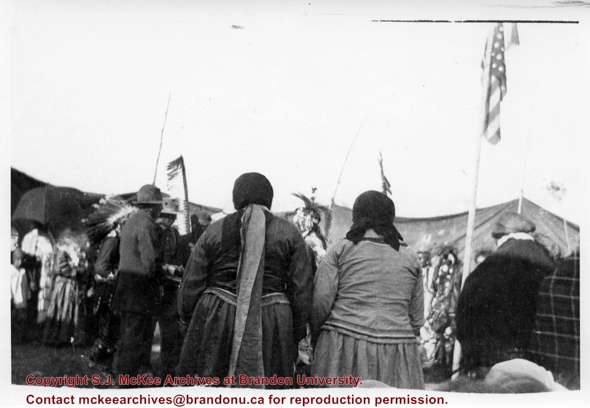
Photograph shows a group of Aboriginal peoples standing in a circle surrounding a group in traditional regalia. An American flag is visible in the foreground.
Notes
Writing on back of photograph reads: 6 prints [20-2009.145 to 20-2009.150]. Indians at the Brandon Fair. Camping off 18th St. back of fair grounds. 1923
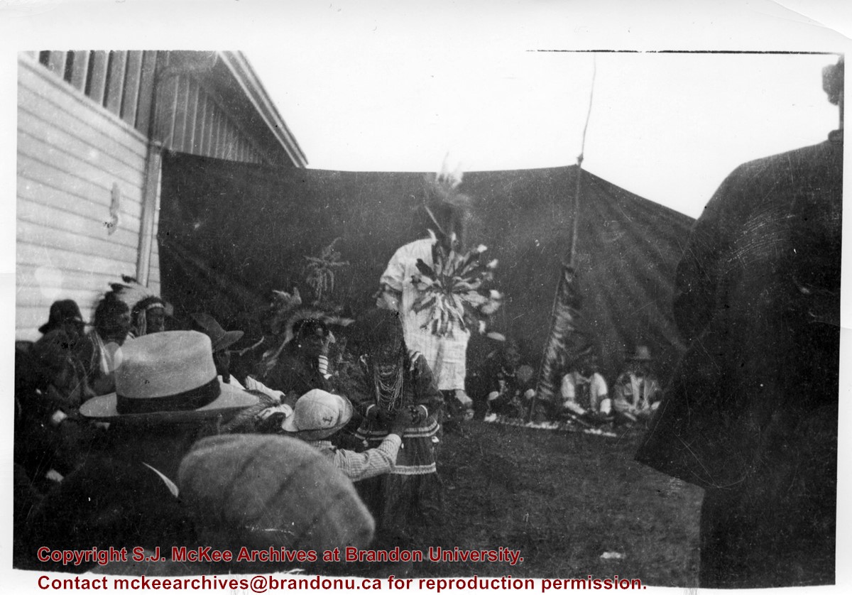
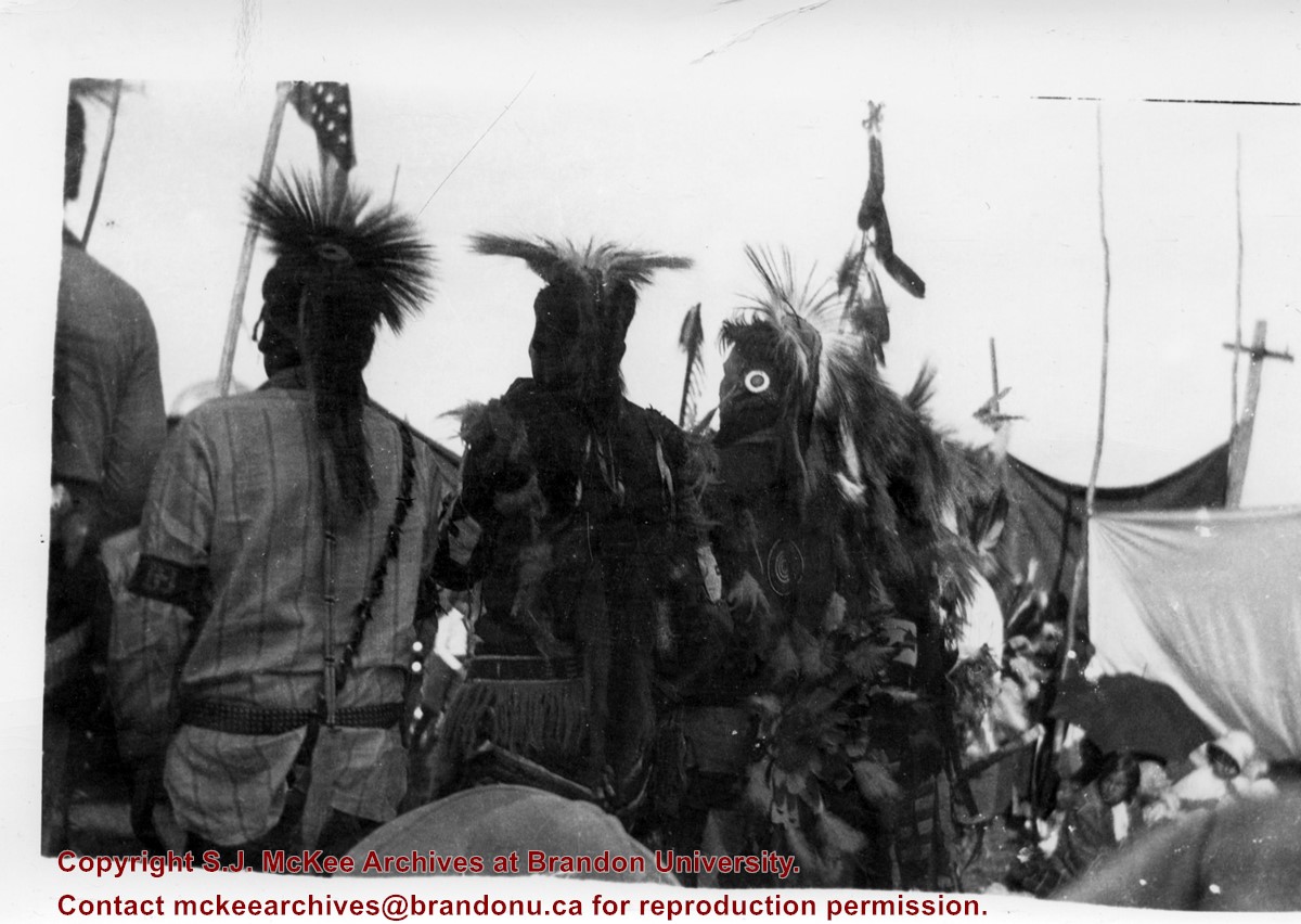
Photograph shows the backside of a group Aboriginal peoples dressed in traditional regalia. An American flag is visible in the background
Notes
Writing on back of photograph reads: 6 prints [20-2009.145 to 20-2009.150]. Indians at the Brandon Fair. Camping off 18th St. back of fair grounds. 1923
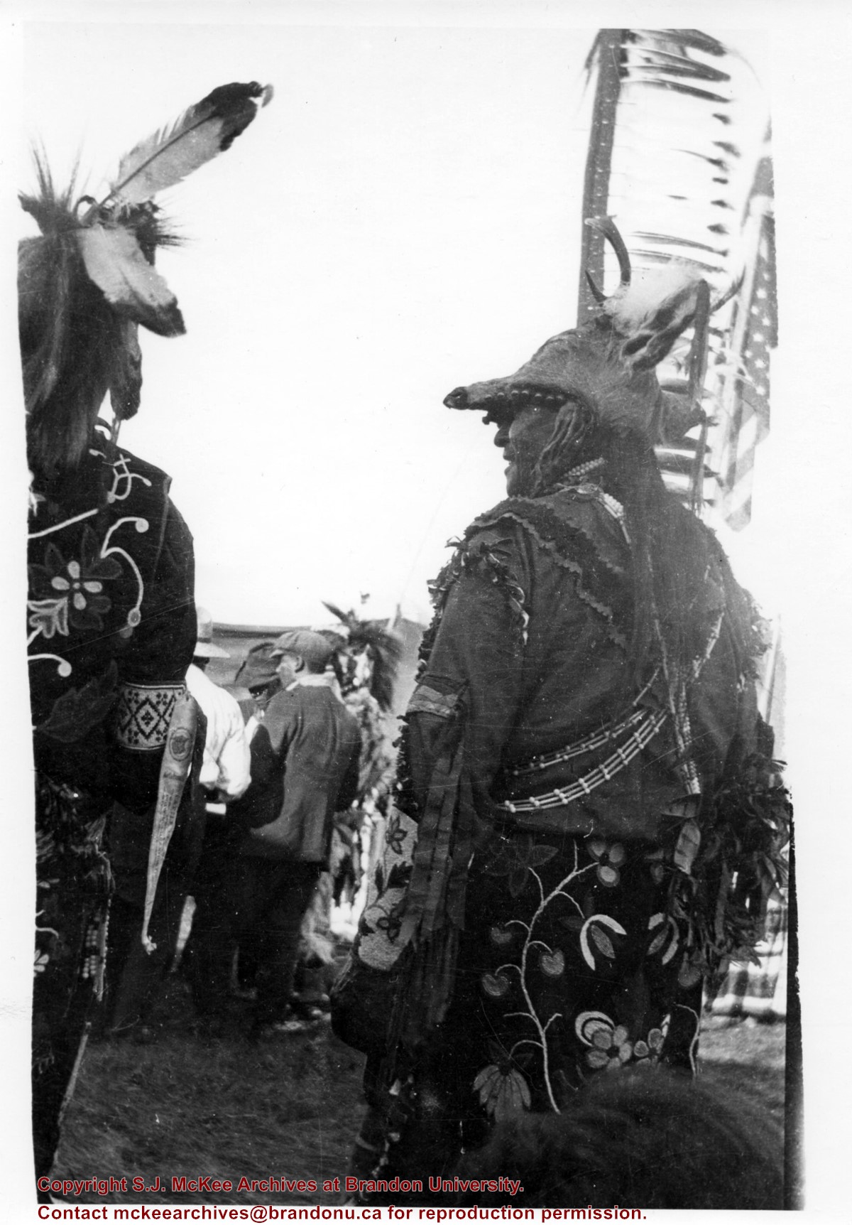
Photograph shows the backside of a pair of Aboriginal men dressed in traditional regalia. Both are wearing beaded clothing and one is wearing a deer head headdress. An American flag is visible in the background
Notes
Writing on back of photograph reads: 6 prints [20-2009.145 to 20-2009.150]. Indians at the Brandon Fair. Camping off 18th St. back of fair grounds. 1923
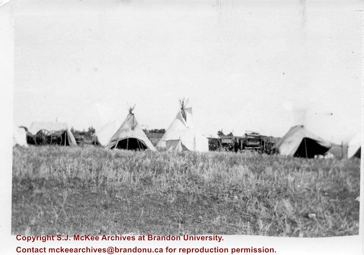
Photograph shows the Aboriginal camp site at the Brandon Fair. Pictured are wagon carts, tipis, and canvas tents.
Notes
Writing on back of photograph reads: 6 prints [20-2009.145 to 20-2009.150]. Indians at the Brandon Fair. Camping off 18th St. back of fair grounds. 1923
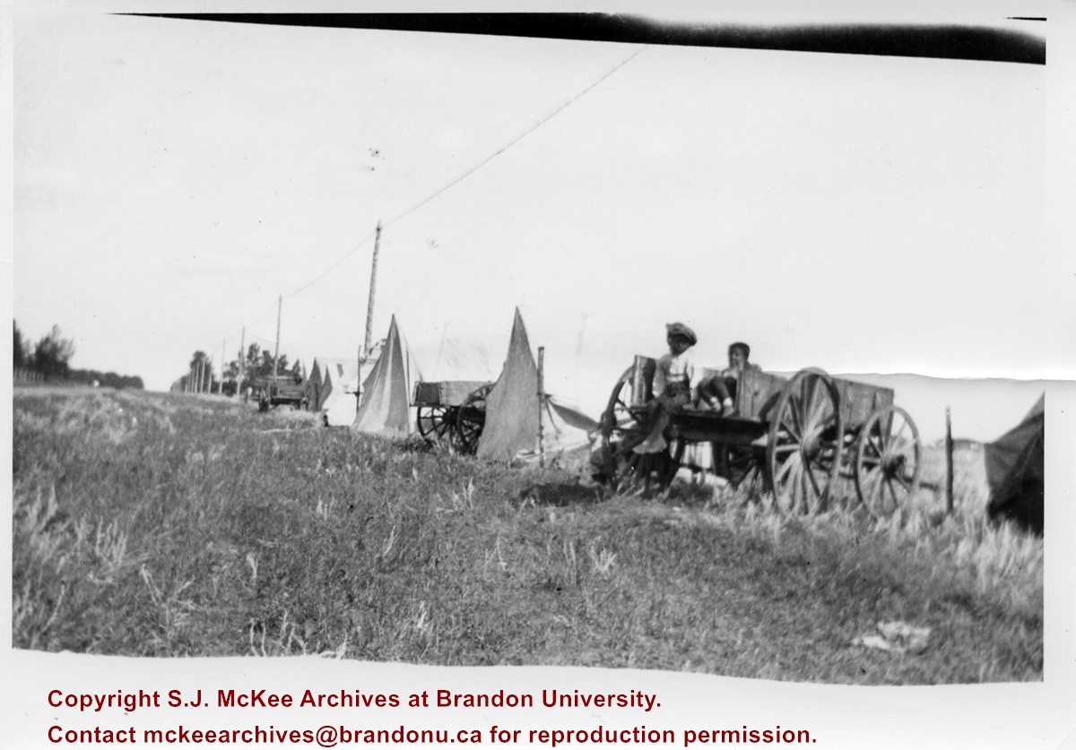
Photograph shows the Aboriginal camp site at the Brandon Fair. Pictured are wagon carts and canvas tents. Two children can be seen sitting in a wagon.
Notes
Writing on back of photograph reads: 6 prints [20-2009.145 to 20-2009.150]. Indians at the Brandon Fair. Camping off 18th St. back of fair grounds. 1923
Archie Cleveland Miller owned and operated a farm near Roland, Manitoba from 1918 to 1938. Miller was engaged principally in a commercial grain operation.
Custodial History
This fonds was accessioned in 1997 by the McKee Archives. Prior custodial history is unknown. .
Scope and Content
Fonds contains legal documents from A.C. Miller's farm near Roland, Manitoba from 1916 to 1938. They include mortgage documents, lease agreements, and bank receipts.
Brandon College looking south from 19th Street. Photograph was taken after Flora Cowan Hall was built but before construction of the Education Building.
Image is looking east northeast from approximately the 300 block of 23rd Street between Lorne and Louise Avenues. Photograph shows the Brandon College campus after the opening of the original Music Building in 1963, but before the construction of the Education Building in 1966. A number of house on the 300 blocks of 22nd and 21st Streets are visible in the foreground, with the A.E. McKenzie Seed Co., the Prince Edward Hotel and various grain elevators on the horizon.
Image shows the Brandon College campus from 17th Street looking southwest. The photo was taken after the completion of the original Music Building in 1963, but construction of the Education Building. Also visible are a number of properties on the 200 block of 18th Street and the 200 block of 20th Street.
View is southwest from approximatley 16th Street between Princess and Rosser Avenues. Photograph shows the Brandon University campus, as well as surrounding residential blocks, including Flemming, J.R. Reid and Vincent Massey schools.
View is west southwest from approximatley 16th Street between Princess and Lorne Avenues. Photograph shows the Brandon University campus, as well as surrounding residential blocks between 16th and 23rd Streets, Princess and Louise Avenues..


)
)