ARCH 2: North Lauder Locale
The North Lauder locale has a long archaeological and geological history that is important for understanding the forces that shaped the region. Archaeological research in the locale shows that the area has been occupied by humans for at least the past 6,500 years. Environmental forces provided an area of diverse resources that attracted early peoples.
Environment of the Lauder Sandhills
The North Lauder locale is part of the greater Lauder Sandhills area. The glaciers that covered this region began to recede approximately 11,000 years ago leaving a large lake known as glacial Lake Hind. The Souris River, the Lauder Sandhills and the Oak Lake Aquifer are remnants of the environmental and geological forces that shaped the region.
The Lauder Sandhills region is characterized by a landscape of sand sheets and stabilized sand dunes interspersed with a variety of wetlands. This complex topographic and hydrological situation favoured the development of an island mosaic of mixed forest, wetland and meadow, surrounded by mixed grass prairie. The result was a large, isolated ecotone which provided a rich variety of subsistence resources for hunter-gatherers.
Research in the Lauder Sandhills
Archaeologists from Brandon University have been conducting research in the Lauder Sandhills since 1991. Research in the North Lauder locale has focused on the Atkinson site, a 6,500 year old hunter-gatherer site and Flintstone Hill.
The Atkinson site
The Atkinson site is one of the oldest excavated sites in Manitoba and has been Radiocarbon dated to 6,500 years before present. The Atkinson site is located on the bank of the Souris River and was discovered when a hearth (fire pit) was seen eroding out of the bank. Based on the date of the site and the kind of lithics (stone tools) present it is considered a Gowen occupation. The Atkinson site is evidence that bison hunters were active on the northern plains at a very early date. Similar sites have also been found on the High Plains in the U.S. and are referred to as the Mummy Cave Complex.
The Atkinson Site is of great importance as it is the first undisturbed site of this type to be excavated in Manitoba and extends the range of these sites south and east from the type-sites in central Saskatchewan.
Flintstone Hill
The geomorphology of the glacial Lake Hind Basin over the past 11,000 years is known primarily through the study of a cut bank along the Souris River. Flint Stone Hill contains the most complete stratigraphic record for the post-glacial period on the northern plains. The site has been extensively studied by geoarchaeologists, geologists and paleoenvironmentalists over many years and their findings have contributed to our understanding of the region.
The North Lauder locale Borden designations of Atkinson site DiMe-27 and Flintstone Hill site DiMe-26.
Borden System
Archaeological sites in Canada are identified by the Borden system, which is a uniform site designation system. The country is divided into grids based on latitude and longitude in blocks of 10 x 20 minutes. The first 4 letters indicate the block and the following numbers indicate the actual site. For example the area of the Lauder Sandhills in southwestern Manitoba is identified by the letters DM and the North Lauder locale within that area is DiMe. The Atkinson site is DiMe-27 and the Flintstone Hill site DiMe-26. As new sites are discovered they will be numbered sequentially.
Scope and Content
The Series has been divided into two sub-series, including (1) Atkinson site DiMe-27 and Flintstone Hill site DiMe-26.
The Lovstrom locale first came to the attention of Dr. Nicholson through conversations with landowners Mr. and Mrs. Herb Lovstrom in 1985. Lovstrom is a multi-component archaeological locale located 25km south of Brandon overlooking the Souris River channel. The landowner’s surface collection and the presence of bone and artifacts in a cultivated field indicated the presence of one or more sites.
Limited testing was conducted in 1985 and 1986, followed by major excavations in 1987, 1988 and 1991. Eight sites of block excavations with a total of 132 1m2 excavation units were completed. The locale area extends approximately 500m north from the edge of the Souris Valley escarpment and over 200m east from the Jock’s Creek escarpment.
Physical and biological environment As has been noted above, the locale is bounded on the south by the Souris channel and on the west by the incised channel of Jock’s Creek and a till plain extends to the north and the east. This plain is characterized by buff colored glacial till with numerous rocks embedded in the surface. Surrounding these rocky knolls are dark-soil hollows where the various cultural occupations are found. The depth of the topsoil layer suggests a long term grassland cover with the present oak forest likely developing in historic times due to the elimination of bison grazing and the controlling of prairie fires in late historic times. A small cleared patch of farmland is found within the boundaries of the locale area. This area has provided a substantial surface collection of artifacts.
Present vegetation in the area is a mosaic of aspen/oak forest groves and mesic grass prairie that includes introduced species such as brome grass. In poorly drained areas, willow and red osier dogwood are present. The Lovstrom locale is found in a forested area dominated by oak with an under story of saskatoon, chokecherry, pin cherry, and hazelnut brush. Poison ivy is abundant as well as sarsaparilla.
The major faunal resources in Precontact times would have been bison, with elk and mule deer playing a minor role. Antelope may have been present also. Small animals included snowshoe hare, cottontails, porcupines and beaver. Canids, including wolf, coyote, fox and domesticated dog were present, as well as mustelids such as badger, mink, and weasel. Fragments from a fisher were also recovered in the excavations.
Summation.
The Lovstrom locale has eight sites. The sites were designated and excavated as Blocks A, B, C, D, E, F, G and H. Many of the sites are multi-occupations.
The Vickers materials are primarily confined to Blocks D, E, F, G and H. Vickers Focus materials overlie Blackduck/Duck Bay materials. Blackduck and Duck Bay materials are found in the lower levels of all excavation blocks and in most test units. The Vickers occupations at the Lovstrom locale, based upon ceramic wares and an overlapping of C14 dates, appear to have been contemporary with the Lowton type site to the east, near Belmont. A small protohistoric occupation was identified overlying part of Block D. Faunal remains are abundant with bison clearly dominating the assemblages. Lesser amounts of canid are present as well as small mammals including beaver, hare and mustelids. Small amounts of avian species are also present.
Publications
Nicholson, B.A.
2011 The Role of Pocket Gophers (Thomomys talpoides) in Restructuring Stratigraphic Relationships at the Lovstrom Site. Canadian Journal of Archaeology 35:323-331.
Nicholson, Bev, Scott Hamilton, Matthew Boyd and Sylvia Nicholson
2008 A Late Plains Woodland Adaptive Strategy in the Northern Parklands: the Vickers Focus Forager-Horticulturists. Invited Paper for Papers in Northeastern Plains Prehistory, eds. Michael G. Michlovic and Dennis L. Toom, North Dakota Journal of Archaeology Vol. 8:19-34.
Nicholson, Bev and Scott Hamilton
2001 Cultural Continuity and Changing Subsistence Strategies During the Late Precontact Period in Southwestern Manitoba. Canadian Journal of Archaeology 25:53-73.
Nicholson, Bev
1996 Plains Woodland Influx and the Blackduck Exodus in South-Western Manitoba During the Late Precontact Period. Manitoba Archaeological Journal 6(1):69-85.
Nicholson, Bev and Mary Malainey
1991 Report on the 1991 Field School Excavations at the Lovstrom Site (DjLx-1), Southwestern Manitoba. Manitoba Archaeological Journal 1(2): 51-93.
Nicholson, Bev and Jane Gibson
1990-91 Lovstrom Site Field Report, 1987 Excavations. Saskatchewan Archaeology 11&12:46-68.
Nicholson, Bev and Ian Kuiijt
1990 Field Report and Interpretations of the 1988 Archaeological Excavations at the Lovstrom Site (DjLx-1) in Southwestern Manitoba. North Dakota Journal of Archaeology 4:166-205.
Nicholson, Bev
1990 Ceramic Affiliations and the Case for Incipient Horticulture in Southwestern Manitoba. Canadian Journal of Archaeology 14:33-60.
Nicholson, Bev
1986 The Lovstrom Site: Culture Contact in Prehistory. Manitoba Archaeological Quarterly 10(1):35-71.
Scope and Content
The Series has been divided into nine sub-series, including (1) Survey (2) Block A; (3) Block B (4) Block C; (5) Block D; (6) Block E; (7) Block F; (8) Block G; (9) Block H
Field journals have been scanned in multi-page PDF files. Artifact catalogues are PDF files in spreadsheet format. Photographs are in jpeg format.
History / Biographical
After the flooding of the Souris River in 2004 receded, Tomasin Playford and her crew of Andrea Richards, Sarah Graham and Shane Kolesar returned to the Atkinson site and commenced cleaning up the earlier excavation of Atkinson.
An area east of the Atkinson excavations was also opened for testing in 2004. This area was designated as Atkinson II. In some of the field notes it is referred to as Atkinson East. A test block was opened and fenced off from the cattle with snow fence. A 4m2 block was surveyed in (units 13 - 16) and two partial units that were truncated by the riverbank (units 11 &12) were also placed to the south of the 4m2 block.
Three of the students who had completed the recent field school were hired as crew. Jessica McKenzie, Evie Fevez and Emily Ansell joined the crew at the Atkinson II site.
Recoveries from XU 13 - 16:
Large bison bone was recovered from units 11 and 12 and a metal tobacco box seal was recovered from unit 12. More small pieces of metal found in levels 2 and three together with small bone fragments. A bone fragment with butchering marks from a metal tool was recovered from level 6 and pottery was found in level 9. A few lithic flakes were found in level 13 and in a trench at the bottom of unit 13 above a calcite cemented layer. Recoveries from these tests were sparse and diminished as the excavation series became more distant from the river. It is likely that the remains that were recovered represent the northern edge of these occupations.
The upper occupation at Atkinson II appears to be an early historic occupation with a sparse scatter of bone and a few pieces of metal. The lower layers, below level 7 are likely precontact. Units 9 and 10 were dug as test pits and produced very little in the way of cultural materials.
Scope and Content
Sub-sub-sub series contains: Summary information of field methology, number and co-ordinates of excavations, personnel and their staff position; Field journals are daily records of recoveries, features and activities at the site; Site records include excavation level and unit summaries, feature sheets, profiles; sample records and maps; Artifact catalogues are lists and identifications of all artifacts recovered; Photographs are of excavation units, features, the landscape and personnel.
The Atkinson site was named for the landowners Ken and Karen Atkinson who were very helpful to the archaeology and geoarchaeology crews that worked at the site. Their support made the project possible.
The Atkinson site story begins with the discovery of a charcoal lens eroding from the north bank of the Souris River in the summer of 2002. Study of Cultural Adaptations on the Prairie Ecozone (SCAPE) project geoarchaeologist Dr. Garry Running was exploring the stratigraphic layering in the bank when he noted the lens and reported it to Dr. Bev Nicholson. Upon closer examination, a tiny pressure flake was observed on the lens exposure and it was decided to collect a charcoal sample for radiocarbon dating.
The resulting date of 5250B.P cal. 4225 B.C. placed the site in the early Archaic period. A second date on bone collagen of 5580B.P. cal. 4500 B.C. confirmed the earlier date and gave an averaged date of circa 4400 B.C or 6,500 years ago.
The Atkinson site is one of the oldest excavated sites in Manitoba. Based on the date of the site and the kind of lithics (stone tools) present it is considered a Gowen occupation. The Atkinson site is evidence that bison hunters were active on the northern plains at a very early date. Similar sites have also been found on the High Plains in the U.S. and are referred to as the Mummy Cave Complex.
The Atkinson Site is of great importance as it is the first undisturbed site of this type to be excavated in Manitoba and extends the range of these sites south and east from the type-sites in central Saskatchewan. Based on the date and sample evidence further excavations were conducted by Dr. Nicholson's team. in 2003, 2004 and 2006.
Scope and Content
Sub series has been divided into three sub sub series including: (1) Atkinson 2003, (2) Atkinson 2004; (3) Atkinson 2006
Field journals have been scanned in multi-page PDF files. Artifact catalogues are PDF files in spreadsheet format. Photographs are in jpeg format.
History / Biographical
Based on the results of the testing in 2002 and the radiocarbon date of 6,500 years before present, further excavation was warranted at the Atkinson site. In 2003 Field Chief Holly Alston and crew Shayne Kolesar and Andrea Richards opened a 42m test excavation (units 1 - 4) that included the hearth area.
The site area was covered with a huge sand dune that was slowly sliding into the river as the supporting bank eroded away. As the dune was removed a late woodland camp was found at the dune interface and a large chunk of charcoal dated this occupation to 440+/-60 B.P. cal.1440A.D. This indicated that the dune was a relatively late incursion over the site. This occupation is likely connected to subsequent testing to the east in 2005 that came to be known as Atkinson II.
Methodology:
The crew began shovel shaving the upper strata with the intention of establishing an arbitrary datum when artifacts were encountered or when a level 25cm above the hearth was reached. At 25cm above the hearth an arbitrary surface datum was established and excavation in 5cm levels began. The overbank deposited matrix was a dense, compacted silt clay and it was necessary to soak the excavated materials in buckets and then water screen the material with a high pressure pump over ¼ inch hardware cloth.
Lithic flakes were found at 10cm below datum, above the hearth level. In the next level, large bone, a broken projectile point and additional flakes were found. Increasing amounts of bone and lithic flakes were found as the excavation continued through levels 3 to 5. The top of the hearth was identified at 28cm below datum, below a 2cm layer of well-sorted sand. This sand layer was confined to a small area directly overlying the hearth. It was considered to be a deliberate quenching of the hearth.
After the conclusion of excavating level 6 the hearth was profiled and photographed. The charcoal and ash layer of the hearth was shown to be directly below the sand layer. Levels 6 and 7 revealed a bison bone bed that was consistent with primary and secondary butchering including elements from the vertebral column and appendicular skeleton. Two additional Gowen (Mummy Cave Series) projectile points were also recovered adjacent to the hearth. Level 8 continued to produce larger amounts of bone and many lithic flakes. Level 9 produced a few bone fragments and a small number of lithic flakes. At the conclusion of the excavations, the crew shoveled sand down from the dune to protect the site over winter and through any subsequent spring flooding.
Scope and Content
Sub-sub-sub series contains: Summary information of field methology, number and co-ordinates of excavations, personnel and their staff position; Field journals are daily records of recoveries, features and activities at the site; Site records include excavation level and unit summaries, feature sheets, profiles; sample records and maps; Artifact catalogues are lists and identifications of all artifacts recovered; Photographs are of excavation units, features, the landscape and personnel.
Field journals have been scanned in multi-page PDF files. Artifact catalogues are PDF files in spreadsheet format. Photographs are in jpeg format.
History / Biographical
In 2004 Tomasin Playford and her crew of Andrea Richards, Sarah Graham and Shane Kolesar cleared sand cover from over the 2003 excavations and extended sand clearing back from the north edge of the 2003 units to permit implementation of four additional units. During this sand clearing a hearth was identified together with small numbers of lithics and pottery body sherds. This occupation had been noted during sand clearing in 2003 and a charcoal sample was collected and radiocarbon dated to 1440 A.D. This hearth was assigned to Atkinson II, a later occupation.
Four units (5, 6, 7, & 8) were surveyed in adjacent to the 2003 units. Excavation proceeded by means of shovel shaving until the datum pegs from the previous year were located. The new units were then given datum pegs and string boundaries and the high pressure pump was set up for water screening of silt/clay matrix.
Continued to shovel shave levels 1 - 4 and recovered small burned and unburned bone fragments. Level 5 produced a projectile point, an end scraper and a large heat-treated Swan River Chert (SRC) flake. Other SRC flakes were also recovered. Levels 6 and 7 yielded large numbers of flake debitage. The matrix in levels 5-7 contained a scatter of small, bright red ochre particles. The river began to rise on the ninth of June and the site was sandbagged on June 11th, temporarily bringing an end to excavation for Atkinson 1. Tomasin and her crew were relocated to the Crepeele site, west of Lauder.
On July 20th, Tomasin and her crew returned to the Atkinson site and commenced cleaning up the earlier excavation following the flooding. Following the clean up, excavations were resumed on the units that had been opened. An additional Gowen point was recovered from level 8 as well as some poorly preserved bison bone. A lot flakes and small amounts of bone were recovered on west side of block and larger bone and flakes in bone bed along the east side in levels 8 - 10. Two bifaces were recovered in level 11 and a third in level 13. The excavations were terminated at level 18 when water started coming up through the unit floors.
Scope and Content
Sub-sub-sub series contains: Summary information of field methology, number and co-ordinates of excavations, personnel and their staff position; Field journals are daily records of recoveries, features and activities at the site; Site records include excavation level and unit summaries, feature sheets, profiles; sample records and maps; Artifact catalogues are lists and identifications of all artifacts recovered; Photographs are of excavation units, features, the landscape and personnel.
Field journals have been scanned in multi-page PDF files. Artifact catalogues are PDF files in spreadsheet format. Photographs are in jpeg format.
History / Biographical
The Atkinson site had been flooded in 2005 and there was concern about the amount of damage that might have occurred. A small crew of Tomasin Playford, Michelle Drysdale and Jessica McKenzie returned to the Atkinson site with the goals of obtaining a detailed profile of the stratigraphy at the north end of the occupation and to determine if the site extended contiguously towards the east. Two test pits were planned as well as the investigation of a couple of hearths found eroding from the riverbank Work commenced July 4th and finished July 21st.
To the north of XU 8 (Gowen occupation) an excavation unit 18 was opened and shovel shaved to a depth of 200cm. At 195cm below surface a point bar deposit was identified indicating that any lower occupations would likely have been eroded by an earlier channel cutting event prior to formation of this point bar depositional event. Golf tees were inserted into the edge of the profile to indicate the 5cm levels superimposed on a digital photo of the section. Lithic flakes and bone fragments were scattered thoughout the stratigraphic column. A radiocarbon date of 440 B.P. was obtained from the unit, indicating a much later occupation than Gowen.
Unit 19 was excavated but only yielded a small Besant component containing a small hearth (H#3) In level 9, a point tip and a small biface as well as a few undecorated pot sherds were recovered. These two units defined the extent of the Atkinson I site. An unknowable area of the site has been eroded away by the encroaching Souris River.
The two small exposed hearths were excavated but only yielded a small amount of material. Hearth 4, at the western edge of the Atkinson block yielded only a small amount of charcoal , mixed with burnt bone and a few small lithic flakes. Hearth 5, located in the high cut bank west of the main site yielded a small amount of bone from a small ungulate, a muskrat and a bird as well as a percussion cap. This latter recovery indicated that this was an early historic period site.
Scope and Content
Sub-sub-sub series contains: Summary information of field methology, number and co-ordinates of excavations, personnel and their staff position; Field journals are daily records of recoveries, features and activities at the site; Site records include excavation level and unit summaries, feature sheets, profiles; sample records and maps; Artifact catalogues are lists and identifications of all artifacts recovered; Photographs are of excavation units, features, the landscape and personnel.
See RG 6, sub-series 4.1 Vice-President (Academic and Research) and 4.2 Vice-President (Administration and Finance) for history/bio information.
Scope and Content
Series consists of records generated and collected by the Office of the Vice-President in the course of performing its functions. The fonds has been divided into two sub-series, including: (1) Vice-President (Academic and Research); and (2) Vice-President (Administration and Finance).
Notes
A portion (2.3 m) of the records in this series are unprocessed.
The high biodiversity and evidence of pre-Europeon contact prompted the decision to test the Crepeele locale. The survey was named in recognition of the Casselman family, the original landowners.
Archaeological testing began in the Crepeele locale in May 2003 on property now owned by the Crepeele family. The locale covers over 6 sections or approximately 3,800 acres of land in an area of stabilized sand dunes and wetlands covered with mixed forest and prairie grass. Given the terrain, the size of the crew and time constrains, an area of approximately 60 acres was chosen for the survey. The survey used the established archaeological methodology of walking the selected area and using a shovel test surveyed grid. The use of GIS technology to locate the exact test spot and record the information into a GIS database was a significant advance and was one of the advantages of the integration of multi-disciplinary techniques encouraged by the SCAPE project. Over one half of the test pits resulted in the recovery of cultural materials. The results of the Casselman survey indicated several areas for further examination including areas that became the Crepeele, Sarah and Graham sites.
Scope and Content
Sub sub series has been divided into five sub sub sub series including: (1) Summary information; (2) Field journals; (3) Site records; (4) Artifact catalogues; and (5) Photographs.
Field journals have been scanned in multi-page PDF files. Artifact catalogues are PDF files in spreadsheet format. Photographs are in jpeg format.
History / Biographical
Archaeological testing began in the Crepeele locale in May 2003 with a field crew of four members. James Graham supervised the crew and was assisted by Sarah Graham, Jollana Bishop, and Lisa Sonnenburg. Later additions to the testing team were Todd Kristensen, Michael Evans, and Emily Ansell.
The methodology for this survey used an arbitrary datum and a transit to establish a grid of 30 m intervals and a shovel test every 20 m. Materials were removed and screened to a minimum depth of 50 cm below surface. All recovered materials were bagged and removed to the lab for further analysis. All information including: test pit grid co-ordinates; UTM co-ordinates for each test pit; artifact presence; excavator; vegetation; aspect; paleosol; paleosol depth; and notes, were entered into a GIS database.
Approximately 600 shovel test pits were excavated and recorded in this fashion. Of the 600 shovel test pits, over 300 contained cultural materials. Based on the results of the Casselman survey several areas were designed for further testing and excavation. Crepeele West and Crepeele East were renamed the Sarah site DiMe-28) and Crepeele 3 which became the Crepeele site DiMe- 29.
Scope and Content
Sub-sub-sub series contains: Summary information of field methology, number and co-ordinates of excavations, personnel and their staff position; Field journalsare daily records of recoveries, features and activities at the site; Site records include excavation level and unit summaries, feature sheets, profiles; sample records and maps; Artifact catalogues are lists and identifications of all artifacts recovered; Photographs are of excavation units, features, the landscape and personnel.
Radiocarbon date reports have been scanned in multi-page PDF files.
History / Biographical
Crepeele locale Radiocarbon Dates. C14 report by IsoTrace Laboratory for Crepeele site 2005 XU 8.
From 2003 to 2008 field work took place at the Crepeele locale with 75 - 1m x1m units excavated.
To help establish the cultural sequence at the locale Radiocarbon dates were obtained from the three sites in the Crepeele locale.
Radiocarbon dating
The technique of radiocarbon dating was developed by Willard Libby and his colleagues at the University of Chicago in 1949.
Radiocarbon dating is used to estimate the age of organic remains from archaeological sites. Organic matter has a radioactive form of carbon (C14) that begins to decay upon death. C14 decays at a steady, known rate of a half life of 5,730 years. The technique is useful for material up to 50,000 years. Fluctuations of C14 in the atmosphere can affect results so dates are calibrated against dendrochronology. Radiocarbon dates are calibrated to calendar years.
Dates are reported in radiocarbon years or Before Present. Before Present refers to dates before 1950. The introduction of massive amounts of C14, due to atomic bomb and surface testing of atomic weapons, has widely increased the standard deviation on all dates after A.D. 1700 causing these dates to be unreliable.
Accelerated mass spectrometry can more accurately measure C14 with smaller samples and can date materials to 80,000 years.
Scope and Content
Sub sub series contains radiocarbon dates from: Crepeele, Sarah and Graham sites.
Radiocarbon date reports have been scanned in multi-page PDF files.
History / Biographical
Crepeele locale Radiocarbon Dates. C14 report by Beta Analytic Inc. for Crepeele site XU 48 and Graham site XU 54.
From 2003 to 2008 field work took place at the Crepeele locale with 75 - 1m x1m units excavated.
To help establish the cultural sequence at the locale Radiocarbon dates were obtained from the three sites in the Crepeele locale.
Radiocarbon dating
The technique of radiocarbon dating was developed by Willard Libby and his colleagues at the University of Chicago in 1949.
Radiocarbon dating is used to estimate the age of organic remains from archaeological sites. Organic matter has a radioactive form of carbon (C14) that begins to decay upon death. C14 decays at a steady, known rate of a half life of 5,730 years. The technique is useful for material up to 50,000 years. Fluctuations of C14 in the atmosphere can affect results so dates are calibrated against dendrochronology. Radiocarbon dates are calibrated to calendar years.
Dates are reported in radiocarbon years or Before Present. Before Present refers to dates before 1950. The introduction of massive amounts of C14, due to atomic bomb and surface testing of atomic weapons, has widely increased the standard deviation on all dates after A.D. 1700 causing these dates to be unreliable.
Accelerated mass spectrometry can more accurately measure C14 with smaller samples and can date materials to 80,000 years.
Scope and Content
Sub sub series contains radiocarbon dates from: Crepeele, Sarah and Graham sites.
Radiocarbon date reports have been scanned in multi-page PDF files.
History / Biographical
Crepeele locale Radiocarbon Dates. C14 report by Beta Analytic Inc. for Crepeele site XUs 8, 30, 50.
From 2003 to 2008 field work took place at the Crepeele locale with 75 - 1m x1m units excavated.
To help establish the cultural sequence at the locale Radiocarbon dates were obtained from the three sites in the Crepeele locale.
Radiocarbon dating
The technique of radiocarbon dating was developed by Willard Libby and his colleagues at the University of Chicago in 1949.
Radiocarbon dating is used to estimate the age of organic remains from archaeological sites. Organic matter has a radioactive form of carbon (C14) that begins to decay upon death. C14 decays at a steady, known rate of a half life of 5,730 years. The technique is useful for material up to 50,000 years. Fluctuations of C14 in the atmosphere can affect results so dates are calibrated against dendrochronology. Radiocarbon dates are calibrated to calendar years.
Dates are reported in radiocarbon years or Before Present. Before Present refers to dates before 1950. The introduction of massive amounts of C14, due to atomic bomb and surface testing of atomic weapons, has widely increased the standard deviation on all dates after A.D. 1700 causing these dates to be unreliable.
Accelerated mass spectrometry can more accurately measure C14 with smaller samples and can date materials to 80,000 years.
Scope and Content
Sub sub series contains radiocarbon dates from: Crepeele, Sarah and Graham sites.
Radiocarbon date reports have been scanned in multi-page PDF files.
History / Biographical
Crepeele locale Radiocarbon Dates. C14 report by IsoTrace Analytic Laboratory for Sarah site XU17.
From 2003 to 2008 field work took place at the Crepeele locale. The Crepeele, Graham and Sarah sites were excavated with 75 - 1m x1m units excavated
To help establish the cultural sequence at the locale Radiocarbon dates were obtained from the three sites in the Crepeele locale.
Radiocarbon dating
The technique of radiocarbon dating was developed by Willard Libby and his colleagues at the University of Chicago in 1949.
Radiocarbon dating is used to estimate the age of organic remains from archaeological sites. Organic matter has a radioactive form of carbon (C14) that begins to decay upon death. C14 decays at a steady, known rate of a half life of 5,730 years. The technique is useful for material up to 50,000 years. Fluctuations of C14 in the atmosphere can affect results so dates are calibrated against dendrochronology. Radiocarbon dates are calibrated to calendar years.
Dates are reported in radiocarbon years or Before Present. Before Present refers to dates before 1950. The introduction of massive amounts of C14, due to atomic bomb and surface testing of atomic weapons, has widely increased the standard deviation on all dates after A.D. 1700 causing these dates to be unreliable.
Accelerated mass spectrometry can more accurately measure C14 with smaller samples and can date materials to 80,000 years.
Scope and Content
Sub sub series contains radiocarbon dates from: Crepeele, Sarah and Graham sites.
Radiocarbon date reports have been scanned in multi-page PDF files.
History / Biographical
Crepeele locale Radiocarbon Dates. C14 report by IsoTrace Analytic Laboratory for Graham site XUs 5 and 8.
From 2003 to 2008 field work took place at the Crepeele locale. The Crepeele, Graham and Sarah sites were excavated with 75 - 1m x1m units excavated
To help establish the cultural sequence at the locale Radiocarbon dates were obtained from the three sites in the Crepeele locale.
Radiocarbon dating
The technique of radiocarbon dating was developed by Willard Libby and his colleagues at the University of Chicago in 1949.
Radiocarbon dating is used to estimate the age of organic remains from archaeological sites. Organic matter has a radioactive form of carbon (C14) that begins to decay upon death. C14 decays at a steady, known rate of a half life of 5,730 years. The technique is useful for material up to 50,000 years. Fluctuations of C14 in the atmosphere can affect results so dates are calibrated against dendrochronology. Radiocarbon dates are calibrated to calendar years.
Dates are reported in radiocarbon years or Before Present. Before Present refers to dates before 1950. The introduction of massive amounts of C14, due to atomic bomb and surface testing of atomic weapons, has widely increased the standard deviation on all dates after A.D. 1700 causing these dates to be unreliable.
Accelerated mass spectrometry can more accurately measure C14 with smaller samples and can date materials to 80,000 years.
Scope and Content
Sub sub series contains radiocarbon dates from: Crepeele, Sarah and Graham sites.
Field journals have been scanned in multi-page PDF files. Artifact catalogues are PDF files in spreadsheet format. Photographs are in jpeg format.
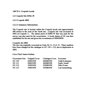
History / Biographical
The Crepeele site was identified from the results of the Casselman survey. The site is located within the Crepeele locale approximately 400 meters to the west of the Sarah site. The units were excavated by Crew Chief James Graham and the crew from the survey.
The Crepeele site was excavated in 2003 as Crepeele 3 with the units numbered as units 10, 11, 12 & 13. These numbers have been changed on the catalogue to XU 110 – 113, due to duplication in 2005. Corresponding documents have been changed but there may be some reference to the initial numbers in the field journals.
The artifacts recovered from these four excavations are faunal (animal bone), mainly bison, lithic materials (stone tools and flakes) and some ceramic (pottery). The artifact catalogue has over 600 records.
Scope and Content
Sub-sub-sub series contains: Summary information of field methology, number and co-ordinates of excavations, personnel and their staff position; Field journalsare daily records of recoveries, features and activities at the site; Site records include excavation level and unit summaries, feature sheets, profiles; sample records and maps; Artifact catalogues are lists and identifications of all artifacts recovered; Photographs are of excavation units, features, the landscape and personnel.
Field journals have been scanned in multi-page PDF files.
History / Biographical
The Crepeele site was excavated in 2003 as Crepeele 3. Standard archaeological methods were used to excavate the units. Excavation units were initially numbered as units 10, 11, 12 & 13. These numbers have been changed on the catalogue to XU 110 – 113, due to duplication in 2005. Corresponding documents have been changed to reflect the amended excavation unit numbers, however the field journals may contain the initial numbers.
Scope and Content
Record of daily observations at the site including: excavation methods, items recovered, features, local environment and weather.
Site records have been scanned in multi-page PDF files.
History / Biographical
The Crepeele site was excavated in 2003 as Crepeele 3. Standard archaeological methods were used to excavate the units. Site records of excavation units XU 110 – 113 are in seperate pdf files.
Scope and Content
Site records of excavation units may include: level summaries, floor plans, feature sheets, wall profiles, unit summaries and any other additional information relating to the unit.
Field journals have been scanned in multi-page PDF files. Artifact catalogues are PDF files in spreadsheet format. Photographs are in jpeg format.
History / Biographical
The Crepeele site was identified from the results of the Casselman survey. The site is located within the Crepeele locale approximately 400 meters to the west of the Sarah site. The units were excavated by Crew Chief James Graham and the crew from the survey.
The Crepeele site was excavated in 2003 as Crepeele 3 with the units numbered as units 10, 11, 12 & 13. These numbers have been changed on the catalogue to XU 110 – 113, due to duplication in 2005. Corresponding documents have been changed but there may be some reference to the initial numbers in the field journals.
The artifacts recovered from these four excavations are faunal (animal bone), mainly bison, lithic materials (stone tools and flakes) and some ceramic (pottery). The artifact catalogue has over 600 records.
Scope and Content
Sub-sub-sub series contains: Summary information of field methology, number and co-ordinates of excavations, personnel and their staff position; Field journalsare daily records of recoveries, features and activities at the site; Site records include excavation level and unit summaries, feature sheets, profiles; sample records and maps; Artifact catalogues are lists and identifications of all artifacts recovered; Photographs are of excavation units, features, the landscape and personnel.