Skip header and navigation

Revise Search

20 records – page 1 of 1.

9th Street aerial view facing south, Brandon, Manitoba

http://archives.brandonu.ca/en/permalink/descriptions8419
Part Of
Joseph H. Hughes collection
Description Level
Item
GMD
graphic
Date Range
c. 1940
Accession Number
3-1997
Part Of
Joseph H. Hughes collection
Creator
Photographer: Jerrett Photo
Description Level
Item
Series Number
3-1997.1
Item Number
3-1997.1.41
Accession Number
3-1997
GMD
graphic
Date Range
c. 1940
Physical Description
5.5" x 3.5" (b/w)
Material Details
postcard
Physical Condition
good
Scope and Content
Postcard shows an aerial view of 9th Street facing south in Brandon, Manitoba. Visible businesses and landmarks include: Beaubier Hotel, YMCA/police station, the original CKX Radio station towers on 8th Street (est. 1928 - moved 1940), the old City Hall, Prince Edward Hotel, and the original Manitoba Power commission smokestack on 10th Street.
Notes
Writing on the front of the photograph reads: Brandon, Man., Jerrett Photo. This photograph shows a rare view of the 800-block between Rosser and Princess Avenues.
Name Access
Beaubier Hotel
City Hall
CKX
Prince Edward Hotel
Manitoba Power Company
Subject Access
downtowns
street scenes
Brandon business buildings & facilities before 1940
aerial views
building exteriors
Storage Location
RG 5 photograph storage drawer
Images
Show Less

10th Street from Princess Avenue facing north, Brandon, Manitoba

http://archives.brandonu.ca/en/permalink/descriptions8402
Part Of
Joseph H. Hughes collection
Description Level
Item
GMD
graphic
Date Range
c. 1955
Accession Number
3-1997
Part Of
Joseph H. Hughes collection
Creator
Photographer: Jerrett Photo
Description Level
Item
Series Number
3-1997.1
Item Number
3-1997.1.24
Accession Number
3-1997
GMD
graphic
Date Range
c. 1955
Physical Description
3.5" x 5.5" (b/w)
Material Details
postcard
Physical Condition
good
Scope and Content
Photograph of 10th Street facing north from Princess Avenue. Vehicles are parallel parked on both sides of the street. The Welcome Brandon sign can be seen at the Rosser Avenue intersection. Visible businesses on the west side of 10th Street include: Doig's, Box Brothers Hardware and Allied Hardware Stores in the Alexandra Block; followed by Simpsons-Sears in the Strathcona Block. Barry Neill Men's Wear, Kresge's and the Cecil Hotel are also visible. The Johnny Smith Block is visible in the background. Visible businesses on the east side of 10th Street include: Ollies Steaks and Chops, Elna Sewing Centre, Carlton Cafe, Chop Suey. At the base of the hill the Canadian Pacific train station is visible at the base of the hill.
Notes
Writing on the front of the postcard reads: Tenth St. Brandon, Man.
Name Access
Strathcona Block
Alexandra Block
Doig's
Box Brothers Hardware
Simpsons-Sears Ltd.
Barry Neill Men's Wear
Kresge
Cecil Hotel
CPR Station
Ollies
Elna Sewing Centre
Carlton Cafe
10th Street
Subject Access
downtowns
street scenes
Brandon business buildings & facilities after 1940
building exteriors
Chinese restaurants
Storage Location
RG 5 photograph storage drawer
Images
Show Less

100-block 10th Street, Brandon, Manitoba

http://archives.brandonu.ca/en/permalink/descriptions8391
Part Of
Joseph H. Hughes collection
Description Level
Item
GMD
graphic
Date Range
c. 1962
Accession Number
3-1997
Part Of
Joseph H. Hughes collection
Description Level
Item
Series Number
3-1997.1
Item Number
3-1997.1.18
Accession Number
3-1997
GMD
graphic
Date Range
c. 1962
Physical Description
8" x 10" (b/w)
Physical Condition
good
Scope and Content
Photograph shows the west side of the 100-block of 10th Street facing northwest. Visible businesses include: Bottomley's Furniture, Recreation Bowling & Billiards, Fashion Fabrics, Brandon News & Record Shop, Bass' Storkland, Beneficial Finance Co., and the Kresge Store. The Johnny Smith Block is visible in the background.
Name Access
Bottomley's Furniture Store
Recreation Bowling and Billiards
Fashion Fabrics
Brandon News & Record Shop
Bass Storkland
Beneficial Finance Co.
Kresge Store
Subject Access
downtowns
street scenes
Brandon business buildings & facilities after 1940
building exteriors
Storage Location
RG 5 photograph storage drawer
Images
Show Less

100-block 10th Street, facing southwest

http://archives.brandonu.ca/en/permalink/descriptions8406
Part Of
Joseph H. Hughes collection
Description Level
Item
GMD
graphic
Date Range
c. 1950s
Accession Number
3-1997
Part Of
Joseph H. Hughes collection
Description Level
Item
Series Number
3-1997.1
Item Number
3-1997.1.28
Accession Number
3-1997
GMD
graphic
Date Range
c. 1950s
Physical Description
10" x 8" (b/w)
Physical Condition
good
Scope and Content
Photograph shows the west side of 10th Street between Rosser and Princess Avenues. Visible businesses include: Brandon News & Record Shop, Fashion Fabrics, Recreation Bowling & Billiards, Bottomley's, Barry Neill Men's Wear, Simpsons-Sears. Painted on the north face of the Strathcona Block are two advertisements, one for Sutherland and Robertson [Grocery] and the other for Boyd Electric Co. Ltd. Union Jack flags hang from some businesses and light standards.
Name Access
10th Street
Brandon News & Record Shop
Fashion Fabrics
Recreation Bowling and Billiards
Bottomley's
Barry Neill Men's Wear
Simpsons-Sears Ltd.
Sutherland and Robertson
Boyd Electric Co. Ltd.
Strathcona Block
Subject Access
downtowns
street scenes
Brandon business buildings & facilities after 1940
building exteriors
Storage Location
RG 5 photograph storage drawer
Images
Show Less

100-block 10th Street, facing southwest (2)

http://archives.brandonu.ca/en/permalink/descriptions8407
Part Of
Joseph H. Hughes collection
Description Level
Item
GMD
graphic
Date Range
c. 1950
Accession Number
3-1997
Part Of
Joseph H. Hughes collection
Description Level
Item
Series Number
3-1997.1
Item Number
3-1997.1.29
Accession Number
3-1997
GMD
graphic
Date Range
c. 1950
Physical Description
8 " x 10" (b/w)
Physical Condition
good
Scope and Content
Photograph shows the west side of 10th Street between Rosser and Princess Avenues. Visible businesses include: Recreation Bowling & Billiards, Bottomley's, Barry Neill Men's Wear, Simpsons-Sears, Allied Hardware Stores, Box Brothers Hardware, Doig's. Painted on the north face of the Strathcona Block are two advertisements, one for Sutherland and Robertson [Grocery] and the other for Boyd Electric Co. Ltd.
Name Access
10th Street
Recreation Bowling and Billiards
Bottomley's
Barry Neill Men's Wear
Simpsons-Sears Ltd.
Sutherland and Robertson
Boyd Electric Co. Ltd.
Strathcona Block
Box Brothers Hardware
Doig's
Allied Hardware
Alexandra Block
Subject Access
downtowns
street scenes
Brandon business buildings & facilities after 1940
building exteriors
Storage Location
RG 5 photograph storage drawer
Images
Show Less

100-block 10th Street, facing west (3)

http://archives.brandonu.ca/en/permalink/descriptions8408
Part Of
Joseph H. Hughes collection
Description Level
Item
GMD
graphic
Date Range
c. 1955
Accession Number
3-1997
Part Of
Joseph H. Hughes collection
Creator
Photographer: R.M. Coleman
Description Level
Item
Series Number
3-1997.1
Item Number
3-1997.1.30
Accession Number
3-1997
GMD
graphic
Date Range
c. 1955
Physical Description
8 " x 5" (b/w)
Physical Condition
good
Scope and Content
Photograph shows the west side of 10th Street between Rosser and Princess Avenues in the winter. Visible businesses include: Bottomley's, Simpsons-Sears, Lionel Electric, Allied Hardware Stores, Box Brothers Hardware, Doig's. Painted on the north face of the Strathcona Block are two advertisements, one for Sutherland and Robertson [Grocery] and the other for Boyd Electric Co. Ltd.
Name Access
10th Street
Bottomley's
Simpsons-Sears Ltd.
Lionel Electric
Sutherland and Robertson
Boyd Electric Co. Ltd.
Strathcona Block
Box Brothers Hardware
Doig's
Allied Hardware
Alexandra Block
Subject Access
downtowns
street scenes
Brandon business buildings & facilities after 1940
building exteriors
winter
Storage Location
RG 5 photograph storage drawer
Images
Show Less

A.E. McKenzie Building construction

http://archives.brandonu.ca/en/permalink/descriptions627
Part Of
Brandon University Photograph collection
Description Level
Item
GMD
graphic
Date Range
[1959-1960]
Part Of
Brandon University Photograph collection
Description Level
Item
Series Number
2.4
Item Number
BUPC 2.4.6
GMD
graphic
Date Range
[1959-1960]
Physical Description
5" x 7" (b/w)
Scope and Content
Photograph is looking northeast (?) and shows the construction of the A.E. McKenzie Building (Library and Arts Building) during the winter.
Subject Access
campus buildings
Images
Show Less

Aerial view: Brandon College

http://archives.brandonu.ca/en/permalink/descriptions594
Part Of
Brandon University Photograph collection
Description Level
Item
GMD
graphic
Date Range
[fall 1964?]
Part Of
Brandon University Photograph collection
Description Level
Item
Series Number
2.1
Item Number
BUPC 2.1.2
GMD
graphic
Date Range
[fall 1964?]
Physical Description
5" x 4" (b/w)
Scope and Content
Brandon College looking south from 19th Street. Photograph was taken after Flora Cowan Hall was built but before construction of the Education Building.
Subject Access
aerial photographs
campus photographs
campus buildings
Brandon streets
Images
Show Less

Aerial view: Brandon College from 23rd Street

http://archives.brandonu.ca/en/permalink/descriptions602
Part Of
Brandon University Photograph collection
Description Level
Item
GMD
graphic
Date Range
[1963-1966]
Part Of
Brandon University Photograph collection
Description Level
Item
Series Number
2.1
Item Number
BUPC 2.1.9
GMD
graphic
Date Range
[1963-1966]
Physical Description
5" x 4" (b/w)
Scope and Content
Image is looking east northeast from approximately the 300 block of 23rd Street between Lorne and Louise Avenues. Photograph shows the Brandon College campus after the opening of the original Music Building in 1963, but before the construction of the Education Building in 1966. A number of house on the 300 blocks of 22nd and 21st Streets are visible in the foreground, with the A.E. McKenzie Seed Co., the Prince Edward Hotel and various grain elevators on the horizon.
Subject Access
aerial photographs
campus photographs
campus buildings
Brandon streets
Grain elevators
Images
Show Less

Aerial view - Brandon College looking southwest

http://archives.brandonu.ca/en/permalink/descriptions601
Part Of
Brandon University Photograph collection
Description Level
Item
GMD
graphic
Date Range
[1963-1966]
Part Of
Brandon University Photograph collection
Description Level
Item
Series Number
2.1
Item Number
BUPC 2.1.8
GMD
graphic
Date Range
[1963-1966]
Physical Description
5" x 4" (b/w)
Scope and Content
Image shows the Brandon College campus from 17th Street looking southwest. The photo was taken after the completion of the original Music Building in 1963, but construction of the Education Building. Also visible are a number of properties on the 200 block of 18th Street and the 200 block of 20th Street.
Subject Access
aerial photographs
campus photographs
campus buildings
Brandon streets
Images
Show Less

Aerial view - Brandon University campus

http://archives.brandonu.ca/en/permalink/descriptions7989
Part Of
Brandon University Photograph collection
Description Level
Item
GMD
graphic
Date Range
c. 2000
Part Of
Brandon University Photograph collection
Creator
Photograph commissioned by Brandon University and taken by Yourview Aerial Scenics Ltd.
Description Level
Item
Series Number
2.1
Item Number
BUPC 2.1.55
GMD
graphic
Date Range
c. 2000
Physical Description
6" x 4" (colour)
Scope and Content
View is southwest from approximatley 16th Street between Princess and Rosser Avenues. Photograph shows the Brandon University campus, as well as surrounding residential blocks, including Flemming, J.R. Reid and Vincent Massey schools.
Subject Access
aerial photographs
campus photographs
campus buildings
Brandon streets
Images
Show Less

Aerial view - Brandon University campus

http://archives.brandonu.ca/en/permalink/descriptions7990
Part Of
Brandon University Photograph collection
Description Level
Item
GMD
graphic
Date Range
c. 2000
Part Of
Brandon University Photograph collection
Creator
Photograph commissioned by Brandon University and taken by Yourview Aerial Scenics Ltd.
Description Level
Item
Series Number
2.1
Item Number
BUPC 2.1.56
GMD
graphic
Date Range
c. 2000
Physical Description
6" x 4" (colour)
Scope and Content
View is west southwest from approximatley 16th Street between Princess and Lorne Avenues. Photograph shows the Brandon University campus, as well as surrounding residential blocks between 16th and 23rd Streets, Princess and Louise Avenues..
Subject Access
aerial photographs
campus photographs
campus buildings
Brandon streets
Images
Show Less

Aerial view - Brandon University campus

http://archives.brandonu.ca/en/permalink/descriptions7991
Part Of
Brandon University Photograph collection
Description Level
Item
GMD
graphic
Date Range
c. 2000
Part Of
Brandon University Photograph collection
Creator
Photograph commissioned by Brandon University and taken by Yourview Aerial Scenics Ltd.
Description Level
Item
Series Number
2.1
Item Number
BUPC 2.1.57
GMD
graphic
Date Range
c. 2000
Physical Description
6" x 4" (colour)
Scope and Content
View is west from approximatley 17th Street between Lorne and Louise Avenues. Photograph shows a portion of the Brandon University campus (excluding the Education Building and anything north of it), as well as surrounding residential blocks from approximatley 17th Street to 22nd Street.
Subject Access
aerial photographs
campus photographs
campus buildings
Brandon streets
Images
Show Less

Aerial view - Brandon University campus

http://archives.brandonu.ca/en/permalink/descriptions7992
Part Of
Brandon University Photograph collection
Description Level
Item
GMD
graphic
Date Range
c. 1990
Part Of
Brandon University Photograph collection
Description Level
Item
Series Number
2.1
Item Number
BUPC 2.1.58
GMD
graphic
Date Range
c. 1990
Physical Description
5" x 3.5" (colour)
Scope and Content
View is west northwest from approximatley 16th Street and Louise Avenue. Photograph shows the Brandon University campus, prior to the Library Extension, and a large portion of the city to the west of the campus.
Subject Access
aerial photographs
campus photographs
campus buildings
Brandon streets
Images
Show Less

Aerial view of 10th Street facing south from Princess Avenue

http://archives.brandonu.ca/en/permalink/descriptions8420
Part Of
Joseph H. Hughes collection
Description Level
Item
GMD
graphic
Date Range
c.1940
Accession Number
3-1997
Part Of
Joseph H. Hughes collection
Creator
Photographer: Jerrett Photo
Description Level
Item
Series Number
3-1997.1
Item Number
3-1997.1.42
Accession Number
3-1997
GMD
graphic
Date Range
c.1940
Physical Description
5.5" x 3.5" (b/w)
Material Details
postcard
Physical Condition
Red ink stain is on the front right corner of postcard
Scope and Content
Photograph shows 10th Street facing south from Princess Avenue. Visible landmarks and businesses include: Manitoba Power Commission (MPC)'s power sub-station, First Baptist Church, Wheat City Arena, and the grand stand at the Exhibition Grounds. The partial sign visible at the bottom of the photograph on the east side of 10th Street reads Yates and Neale, which refers to a plumbing and heating company that dissolved in 1943 to be replaced by Neale, Stothard and Chapman. Businesses on the west side of 10th Street include: Dominion Tire & Radio Co., Bolts Barber Shop, Elviss T.E. Co. Stables.
Notes
Information concerning Yates and Neale courtesy Jack Stothard. Writing on the front of the postcard reads: Brandon, Looking S.W., Jerrett Photo. This photograph shows a rare view of the 200-block of 10th Street.
Name Access
Manitoba Power Company
10th Street
Dominion Tire & Radio Co.
T.E. Elviss Co. Stables
First Baptist Church
Subject Access
downtowns
street scenes
Brandon business buildings & facilities before 1940
aerial views
building exteriors
residences
churches
Storage Location
RG 5 photograph storage drawer
Images
Show Less

Architect's drawing of proposed Federal Building, Princess Avenue between 10th and 11th Street, Brandon, Manitoba

http://archives.brandonu.ca/en/permalink/descriptions8423
Part Of
Joseph H. Hughes collection
Description Level
Item
GMD
graphic
Date Range
c.1930
Accession Number
3-1997
Part Of
Joseph H. Hughes collection
Creator
Shillinglaw, Brandon architect
Description Level
Item
Series Number
3-1997.1
Item Number
3-1997.1.44
Accession Number
3-1997
GMD
graphic
Date Range
c.1930
Physical Description
6.75" x 4.5" (b/w)
Physical Condition
good
Scope and Content
Architect's drawing of the proposed Federal Building on Princess Avenue between 10th and 11th Streets, Brandon, Manitoba.
Name Access
Federal Building
Walter Shillinglaw
Subject Access
downtowns
Brandon business buildings & facilities before 1940
architecture
Storage Location
RG 5 photograph storage drawer
Images
Show Less

Bank of Montreal - 10th Street and Rosser, Brandon, Manitoba

http://archives.brandonu.ca/en/permalink/descriptions8384
Part Of
Joseph H. Hughes collection
Description Level
Item
GMD
graphic
Date Range
c. 1959
Accession Number
3-1997
Part Of
Joseph H. Hughes collection
Description Level
Item
Series Number
3-1997.1
Item Number
3-1997.1.12
Accession Number
3-1997
GMD
graphic
Date Range
c. 1959
Physical Description
8" x 10" (b/w)
Physical Condition
good
Scope and Content
Photograph shows the southeast corner of 10th Street and Rosser Avenue, Brandon, Manitoba. The Bank of Montreal is situated on the corner. Visible businesses along the east side of 10th Street include: Barclay's Shoe Store, Carlton Cafe, and Ted Heming Jewellers.
Name Access
Bank of Montreal
Barclay's Shoe Store
Carlton Cafe
Ted Heming Jewellers
Subject Access
downtowns
street scenes
Brandon business buildings & facilities after 1940
building exteriors
banks
Storage Location
RG 5 photograph storage drawer
Images
Show Less

Brandon train station

http://archives.brandonu.ca/en/permalink/descriptions14273
Part Of
Joseph H. Hughes collection
Description Level
Item
GMD
graphic
Date Range
[1905-1911]
Accession Number
3-1997
Part Of
Joseph H. Hughes collection
Creator
Photographer: Frank Gowen
Description Level
Item
Series Number
3-1997.1
Item Number
3-1997.1.75
Accession Number
3-1997
Other Numbers
Hughes #71
GMD
graphic
Date Range
[1905-1911]
Physical Description
9.5" x 7.5" (b/w)
Material Details
on matting
Physical Condition
Photograph is stained
Scope and Content
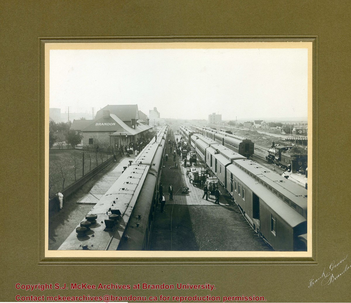
Photograph shows a CPR passenger trains at the old Brandon train station. Carts/trolleys appear to be loaded with wooden crates and metal milk containers. Photograph was likely taken from the 8th Street Bridge. The ramp to the 8th Street Bridge can be seen on the ride of the photograph, where residences line Assiniboine Avenue.
Name Access
Assiniboine Avenue - Early Scene
8th Street Bridge
Subject Access
residences
building exteriors
residential streets
railway stations
railroads
Storage Location
Hughes oversize drawer
Images
Show Less

Brandon University campus

http://archives.brandonu.ca/en/permalink/descriptions7997
Part Of
Brandon University Photograph collection
Description Level
Item
GMD
graphic
Date Range
c. 1996
Part Of
Brandon University Photograph collection
Creator
Photographer: Sandy Black
Description Level
Item
Series Number
2.1
Item Number
BUPC 2.1.63
GMD
graphic
Date Range
c. 1996
Physical Description
6" x 4" (colour)
Scope and Content
View is northwest from the roof of the John R. Brodie Science Centre. Photograph shows the roof of the Knowles Douglas Students' Union Centre, the Citizens' Science Building, and the Brandon College Building and Clark Hall during renovation.
Subject Access
campus photographs
campus buildings
campus construction
Images
Show Less

Brandon University campus

http://archives.brandonu.ca/en/permalink/descriptions7999
Part Of
Brandon University Photograph collection
Description Level
Item
GMD
graphic
Date Range
c. 1993
Part Of
Brandon University Photograph collection
Description Level
Item
Series Number
2.1
Item Number
BUPC 2.1.65
GMD
graphic
Date Range
c. 1993
Physical Description
4" x 6" (colour)
Scope and Content
View is southwest from the roof of the George T. Richardson Centre. Photograph shows the curved glass wall of the John E. Robbins Library, the walkway between the Library and the Dining Hall, the Dining Hall and Darrach Hall.
Subject Access
campus photographs
campus buildings
Images
Show Less

20 records – page 1 of 1.