Brandon College looking south from 19th Street. Photograph was taken after Flora Cowan Hall was built but before construction of the Education Building.
Image is looking east northeast from approximately the 300 block of 23rd Street between Lorne and Louise Avenues. Photograph shows the Brandon College campus after the opening of the original Music Building in 1963, but before the construction of the Education Building in 1966. A number of house on the 300 blocks of 22nd and 21st Streets are visible in the foreground, with the A.E. McKenzie Seed Co., the Prince Edward Hotel and various grain elevators on the horizon.
Image shows the Brandon College campus from 17th Street looking southwest. The photo was taken after the completion of the original Music Building in 1963, but construction of the Education Building. Also visible are a number of properties on the 200 block of 18th Street and the 200 block of 20th Street.
View is southwest from approximatley 16th Street between Princess and Rosser Avenues. Photograph shows the Brandon University campus, as well as surrounding residential blocks, including Flemming, J.R. Reid and Vincent Massey schools.
View is west southwest from approximatley 16th Street between Princess and Lorne Avenues. Photograph shows the Brandon University campus, as well as surrounding residential blocks between 16th and 23rd Streets, Princess and Louise Avenues..
View is west from approximatley 17th Street between Lorne and Louise Avenues. Photograph shows a portion of the Brandon University campus (excluding the Education Building and anything north of it), as well as surrounding residential blocks from approximatley 17th Street to 22nd Street.
View is west northwest from approximatley 16th Street and Louise Avenue. Photograph shows the Brandon University campus, prior to the Library Extension, and a large portion of the city to the west of the campus.
View is northwest from approximatley 16th Street and Louise Avenue. Photograph shows the Brandon University campus, prior to the Library Extension, and a large portion of the city to the west of the campus.
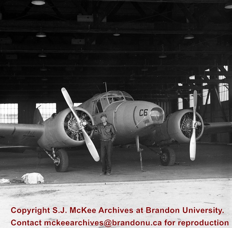
The Avro Anson is a British twin-engine, multi-role aircraft that served with the Royal Air Force, Fleet Air Arm and numerous other air forces prior to, during, and after the Second World War. Suitable as a multi-engine air crew trainer, the plane became a mainstay of the British Commonwealth Air Training Plan.
DEW refers to the distant early warning line in the Arctic.
Custodial History
See fonds level of the CKX records for custodial history.
Scope and Content
Image of a man and plane in an airplane hanger.
Notes
History/Bio information taken from the Avro Anson entry on Wikipedia (November 2010) available at: http://en.wikipedia.org/wiki/Avro_Anson.
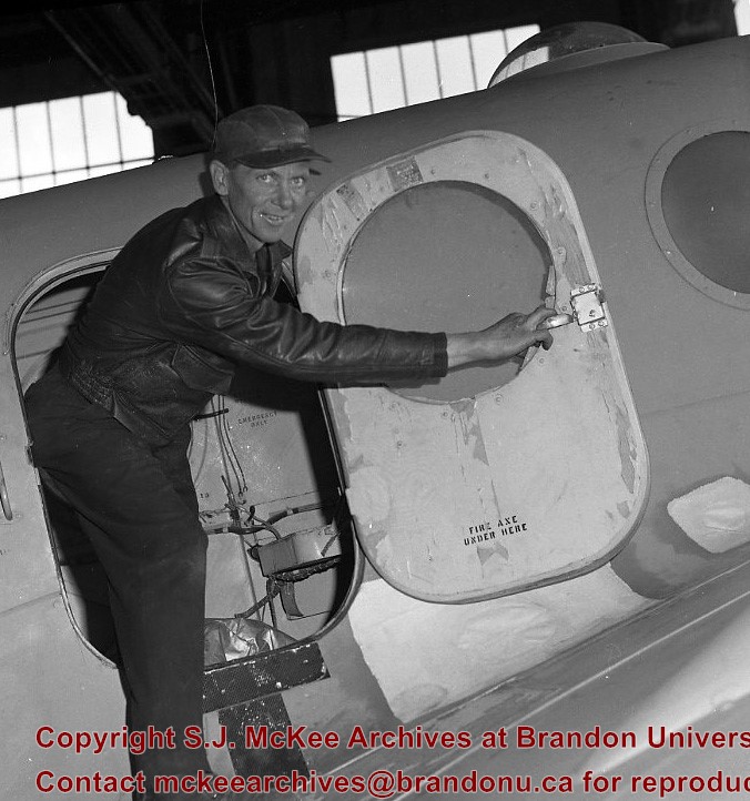
The Avro Anson is a British twin-engine, multi-role aircraft that served with the Royal Air Force, Fleet Air Arm and numerous other air forces prior to, during, and after the Second World War. Suitable as a multi-engine air crew trainer, the plane became a mainstay of the British Commonwealth Air Training Plan.
DEW refers to the distant early warning line in the Arctic.
Custodial History
See fonds level of the CKX records for custodial history.
Scope and Content
Image of a man at the door of the plane.
Notes
History/Bio information taken from the Avro Anson entry on Wikipedia (November 2010) available at: http://en.wikipedia.org/wiki/Avro_Anson.
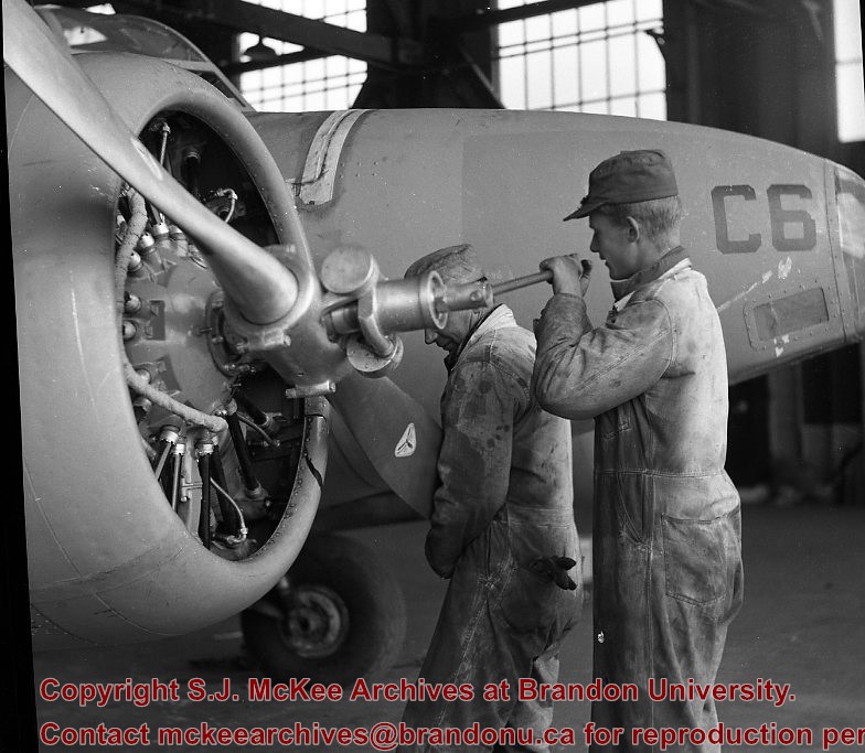
The Avro Anson is a British twin-engine, multi-role aircraft that served with the Royal Air Force, Fleet Air Arm and numerous other air forces prior to, during, and after the Second World War. Suitable as a multi-engine air crew trainer, the plane became a mainstay of the British Commonwealth Air Training Plan.
DEW refers to the distant early warning line in the Arctic.
Custodial History
See fonds level of the CKX records for custodial history.
Scope and Content
Image of two men working on the plane's propeller.
Notes
History/Bio information taken from the Avro Anson entry on Wikipedia (November 2010) available at: http://en.wikipedia.org/wiki/Avro_Anson.
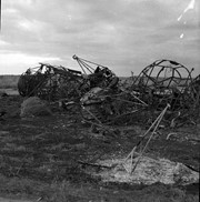
The Avro Anson is a British twin-engine, multi-role aircraft that served with the Royal Air Force, Fleet Air Arm and numerous other air forces prior to, during, and after the Second World War. Suitable as a multi-engine air crew trainer, the plane became a mainstay of the British Commonwealth Air Training Plan.
DEW refers to the distant early warning line in the Arctic.
Custodial History
See fonds level of the CKX records for custodial history.
Scope and Content
Image of some kind of wreckage.
Notes
History/Bio information taken from the Avro Anson entry on Wikipedia (November 2010) available at: http://en.wikipedia.org/wiki/Avro_Anson.
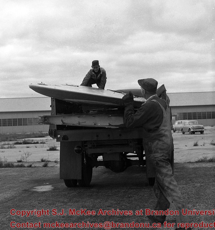
The Avro Anson is a British twin-engine, multi-role aircraft that served with the Royal Air Force, Fleet Air Arm and numerous other air forces prior to, during, and after the Second World War. Suitable as a multi-engine air crew trainer, the plane became a mainstay of the British Commonwealth Air Training Plan.
DEW refers to the distant early warning line in the Arctic.
Custodial History
See fonds level of the CKX records for custodial history.
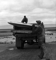
Scope and Content
Image of two men loading the wings of a plane into the flatbed of a truck.
Notes
History/Bio information taken from the Avro Anson entry on Wikipedia (November 2010) available at: http://en.wikipedia.org/wiki/Avro_Anson.
View is northeast probably from the roof of McMaster Hall. Photograph shows the construction of the new roof on Clark Hall and the Brandon College Building. A portion of the east side of the 000 and 100 blocks of 18th Street, as well as the corner of 18th Street and Rosser Avenue are visible in the upper left hand corner. This includes the "Downtown Brandon" sign.
View is north northeast probably from the roof of McMaster Hall. Photograph shows the construction of the new roof on Clark Hall and the Brandon College Building, as well as the construction of the extension to Clark Hall and the skywalk. Portions of the city as far north as the Assiniboine River are also visible.


)