Skip header and navigation

Revise Search

19 records – page 1 of 1.

Aerial view: Brandon College

http://archives.brandonu.ca/en/permalink/descriptions594
Part Of
Brandon University Photograph collection
Description Level
Item
GMD
graphic
Date Range
[fall 1964?]
Part Of
Brandon University Photograph collection
Description Level
Item
Series Number
2.1
Item Number
BUPC 2.1.2
GMD
graphic
Date Range
[fall 1964?]
Physical Description
5" x 4" (b/w)
Scope and Content
Brandon College looking south from 19th Street. Photograph was taken after Flora Cowan Hall was built but before construction of the Education Building.
Subject Access
aerial photographs
campus photographs
campus buildings
Brandon streets
Images
Show Less

Aerial view: Brandon College from 23rd Street

http://archives.brandonu.ca/en/permalink/descriptions602
Part Of
Brandon University Photograph collection
Description Level
Item
GMD
graphic
Date Range
[1963-1966]
Part Of
Brandon University Photograph collection
Description Level
Item
Series Number
2.1
Item Number
BUPC 2.1.9
GMD
graphic
Date Range
[1963-1966]
Physical Description
5" x 4" (b/w)
Scope and Content
Image is looking east northeast from approximately the 300 block of 23rd Street between Lorne and Louise Avenues. Photograph shows the Brandon College campus after the opening of the original Music Building in 1963, but before the construction of the Education Building in 1966. A number of house on the 300 blocks of 22nd and 21st Streets are visible in the foreground, with the A.E. McKenzie Seed Co., the Prince Edward Hotel and various grain elevators on the horizon.
Subject Access
aerial photographs
campus photographs
campus buildings
Brandon streets
Grain elevators
Images
Show Less

Aerial view - Brandon College looking southwest

http://archives.brandonu.ca/en/permalink/descriptions601
Part Of
Brandon University Photograph collection
Description Level
Item
GMD
graphic
Date Range
[1963-1966]
Part Of
Brandon University Photograph collection
Description Level
Item
Series Number
2.1
Item Number
BUPC 2.1.8
GMD
graphic
Date Range
[1963-1966]
Physical Description
5" x 4" (b/w)
Scope and Content
Image shows the Brandon College campus from 17th Street looking southwest. The photo was taken after the completion of the original Music Building in 1963, but construction of the Education Building. Also visible are a number of properties on the 200 block of 18th Street and the 200 block of 20th Street.
Subject Access
aerial photographs
campus photographs
campus buildings
Brandon streets
Images
Show Less

Aerial view - Brandon University campus

http://archives.brandonu.ca/en/permalink/descriptions7989
Part Of
Brandon University Photograph collection
Description Level
Item
GMD
graphic
Date Range
c. 2000
Part Of
Brandon University Photograph collection
Creator
Photograph commissioned by Brandon University and taken by Yourview Aerial Scenics Ltd.
Description Level
Item
Series Number
2.1
Item Number
BUPC 2.1.55
GMD
graphic
Date Range
c. 2000
Physical Description
6" x 4" (colour)
Scope and Content
View is southwest from approximatley 16th Street between Princess and Rosser Avenues. Photograph shows the Brandon University campus, as well as surrounding residential blocks, including Flemming, J.R. Reid and Vincent Massey schools.
Subject Access
aerial photographs
campus photographs
campus buildings
Brandon streets
Images
Show Less

Aerial view - Brandon University campus

http://archives.brandonu.ca/en/permalink/descriptions7990
Part Of
Brandon University Photograph collection
Description Level
Item
GMD
graphic
Date Range
c. 2000
Part Of
Brandon University Photograph collection
Creator
Photograph commissioned by Brandon University and taken by Yourview Aerial Scenics Ltd.
Description Level
Item
Series Number
2.1
Item Number
BUPC 2.1.56
GMD
graphic
Date Range
c. 2000
Physical Description
6" x 4" (colour)
Scope and Content
View is west southwest from approximatley 16th Street between Princess and Lorne Avenues. Photograph shows the Brandon University campus, as well as surrounding residential blocks between 16th and 23rd Streets, Princess and Louise Avenues..
Subject Access
aerial photographs
campus photographs
campus buildings
Brandon streets
Images
Show Less

Aerial view - Brandon University campus

http://archives.brandonu.ca/en/permalink/descriptions7991
Part Of
Brandon University Photograph collection
Description Level
Item
GMD
graphic
Date Range
c. 2000
Part Of
Brandon University Photograph collection
Creator
Photograph commissioned by Brandon University and taken by Yourview Aerial Scenics Ltd.
Description Level
Item
Series Number
2.1
Item Number
BUPC 2.1.57
GMD
graphic
Date Range
c. 2000
Physical Description
6" x 4" (colour)
Scope and Content
View is west from approximatley 17th Street between Lorne and Louise Avenues. Photograph shows a portion of the Brandon University campus (excluding the Education Building and anything north of it), as well as surrounding residential blocks from approximatley 17th Street to 22nd Street.
Subject Access
aerial photographs
campus photographs
campus buildings
Brandon streets
Images
Show Less

Aerial view - Brandon University campus

http://archives.brandonu.ca/en/permalink/descriptions7992
Part Of
Brandon University Photograph collection
Description Level
Item
GMD
graphic
Date Range
c. 1990
Part Of
Brandon University Photograph collection
Description Level
Item
Series Number
2.1
Item Number
BUPC 2.1.58
GMD
graphic
Date Range
c. 1990
Physical Description
5" x 3.5" (colour)
Scope and Content
View is west northwest from approximatley 16th Street and Louise Avenue. Photograph shows the Brandon University campus, prior to the Library Extension, and a large portion of the city to the west of the campus.
Subject Access
aerial photographs
campus photographs
campus buildings
Brandon streets
Images
Show Less

Aerial view - Brandon University campus

http://archives.brandonu.ca/en/permalink/descriptions7993
Part Of
Brandon University Photograph collection
Description Level
Item
GMD
graphic
Date Range
c. 1990
Part Of
Brandon University Photograph collection
Description Level
Item
Series Number
2.1
Item Number
BUPC 2.1.59
GMD
graphic
Date Range
c. 1990
Physical Description
5" x 3.5" (colour)
Scope and Content
View is northwest from approximatley 16th Street and Louise Avenue. Photograph shows the Brandon University campus, prior to the Library Extension, and a large portion of the city to the west of the campus.
Subject Access
aerial photographs
campus photographs
campus buildings
Brandon streets
Show Less

Brandon University campus construction

http://archives.brandonu.ca/en/permalink/descriptions8005
Part Of
Brandon University Photograph collection
Description Level
Item
GMD
graphic
Date Range
c. 1996
Part Of
Brandon University Photograph collection
Creator
Photographer: Sandy Black
Description Level
Item
Series Number
2.1
Item Number
BUPC 2.1.71
GMD
graphic
Date Range
c. 1996
Physical Description
4" x 6" (colour)
Scope and Content
View is northeast probably from the roof of McMaster Hall. Photograph shows the construction of the new roof on Clark Hall and the Brandon College Building. A portion of the east side of the 000 and 100 blocks of 18th Street, as well as the corner of 18th Street and Rosser Avenue are visible in the upper left hand corner. This includes the "Downtown Brandon" sign.
Subject Access
campus photographs
campus buildings
campus construction
Brandon streets
Images
Show Less

Brandon University campus construction

http://archives.brandonu.ca/en/permalink/descriptions8006
Part Of
Brandon University Photograph collection
Description Level
Item
GMD
graphic
Date Range
c. 1996
Part Of
Brandon University Photograph collection
Creator
Photographer: Sandy Black
Description Level
Item
Series Number
2.1
Item Number
BUPC 2.1.72
GMD
graphic
Date Range
c. 1996
Physical Description
6" x 4" (colour)
Scope and Content
View is north northeast probably from the roof of McMaster Hall. Photograph shows the construction of the new roof on Clark Hall and the Brandon College Building, as well as the construction of the extension to Clark Hall and the skywalk. Portions of the city as far north as the Assiniboine River are also visible.
Subject Access
campus photographs
campus buildings
campus construction
Brandon streets
Images
Show Less

Brandon University campus construction

http://archives.brandonu.ca/en/permalink/descriptions8016
Part Of
Brandon University Photograph collection
Description Level
Item
GMD
graphic
Date Range
c. 1996
Part Of
Brandon University Photograph collection
Creator
Photographer: Sandy Black
Description Level
Item
Series Number
2.1
Item Number
BUPC 2.1.82
GMD
graphic
Date Range
c. 1996
Physical Description
4" x 6" (colour)
Scope and Content
View is northeast from the Brandon College Building. Photograph shows the inside of the Brandon College Building after it had been gutted and then partially rebuilt. The exterior fascade of the west side of the building can be clearly seen in this photograph. A number of houses on the east side of 200 block of 18th Street are also visible, as is the stone fence on Princess Avenue and the flag pole on the front lawn.
Subject Access
campus photographs
campus construction
Brandon streets
Images
Show Less

Brandon University campus construction

http://archives.brandonu.ca/en/permalink/descriptions8018
Part Of
Brandon University Photograph collection
Description Level
Item
GMD
graphic
Date Range
c. 1996
Part Of
Brandon University Photograph collection
Description Level
Item
Series Number
2.1
Item Number
BUPC 2.1.84
GMD
graphic
Date Range
c. 1996
Physical Description
6" x 4" (colour)
Scope and Content
View is north northeast from the roof of McMaster Hall. Photograph shows the campus under construction during the renovation of the Brandon College Building and Clark Hall. The photograph was taken in late fall after the roof had been removed from the buildings but before the construction of the extension of Clark Hall. Construction materials litter the courtyard and driveway. The view looking north extends to The North Hill - a number of residential blocks, particularly to the northeast of 18th Street are visible. Buildings include the International Harvester Building and Kin Village.
Subject Access
campus photographs
campus buildings
campus construction
Brandon streets
Images
Show Less

Brandon University campus construction

http://archives.brandonu.ca/en/permalink/descriptions8020
Part Of
Brandon University Photograph collection
Description Level
Item
GMD
graphic
Date Range
c. 1996
Part Of
Brandon University Photograph collection
Creator
Photographer: Sandy Black
Description Level
Item
Series Number
2.1
Item Number
BUPC 2.1.86
GMD
graphic
Date Range
c. 1996
Physical Description
6" x 4" (colour)
Scope and Content
View is north northeast probably from the roof of McMaster Hall. Photograph shows the construction of the new roof on Clark Hall and the Brandon College Building, as well as the construction of the extension to Clark Hall and the skywalk. The view looking north extends to The North Hill - a number of residential blocks, particularly to the northeast of 18th Street are visible. Buildings include the International Harvester Building and Kin Village.
Subject Access
campus photographs
campus buildings
campus construction
Brandon streets
Images
Show Less

City of Brandon "See you in '82" float

http://archives.brandonu.ca/en/permalink/descriptions14318
Part Of
Brandon and Area Photograph Collection
Description Level
Item
GMD
graphic
Date Range
c. 1980
Part Of
Brandon and Area Photograph Collection
Description Level
Item
Series Number
2
Item Number
BAPC 2.44
GMD
graphic
Date Range
c. 1980
Physical Description
5" x 8" (b/w)
Scope and Content
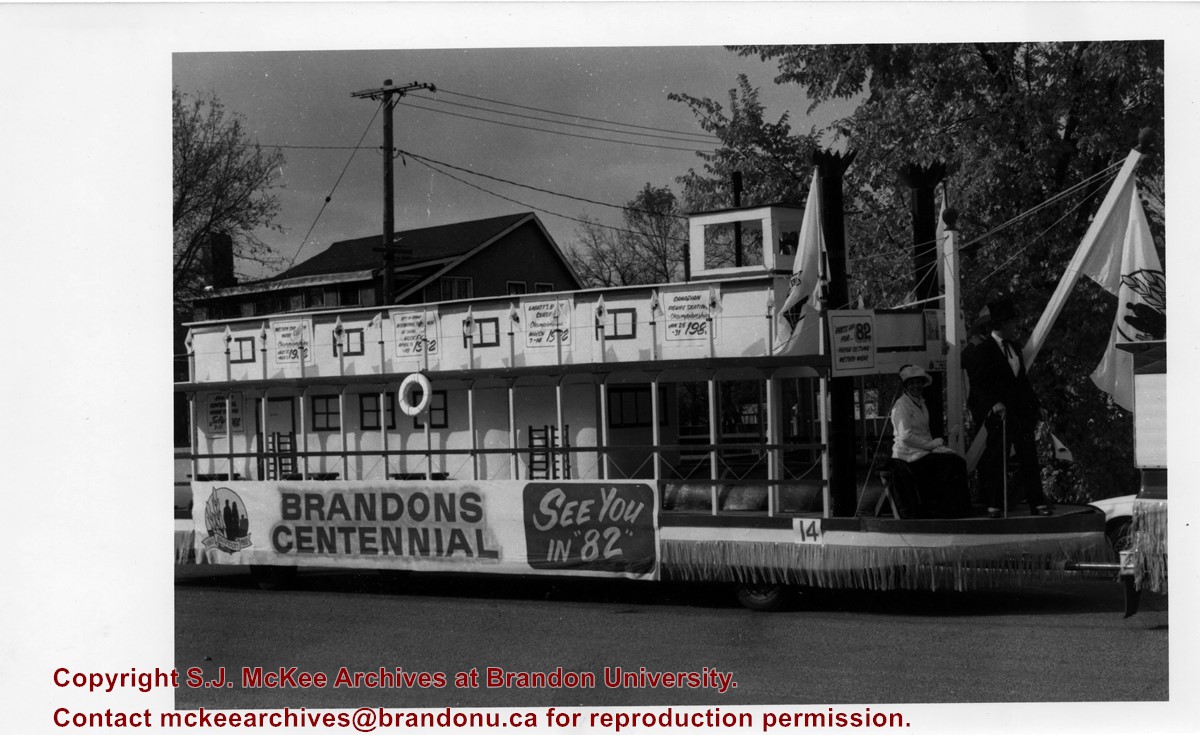
Item is a photograph of the City of Brandon's "See you in '82" float advertising Brandon's upcoming Centennial in 1982. The float is a steamboat and features a number of posters.
Name Access
City of Brandon
Subject Access
parades
floats
centennials
celebrations
Storage Location
BAPC photograph drawer
Images
Show Less

Dr. Stuart Schultz

http://archives.brandonu.ca/en/permalink/descriptions14322
Part Of
Brandon and Area Photograph Collection
Description Level
Item
GMD
graphic
Date Range
1956-1957
Part Of
Brandon and Area Photograph Collection
Description Level
Item
Series Number
5
Item Number
BAPC 5.14
GMD
graphic
Date Range
1956-1957
Physical Description
3" x 4.5" (b/w)
History / Biographical
Stuart Duncan Schultz was born on December 24, 1892 in Belmont, MB to Frank Albert Schultz and Margaret Maria MacPhail. He graduated from the Manitoba Medical College and then continued his studies with four years at the London Royal College of Physicians and Surgeons. Schultz served with the 226th Overseas Battalion of the Canadian Expeditionary Force (CEF) during World War I. Schultz returned from England in 1925, at which point he joined the medical staff of the Brandon Hospital for Mental Diseases (later the BMHC). In 1942, he became Superintendent, and in 1959, he retired. During his time in Brandon, Schultz served fourteen years on city council and was Mayor from 1956-1957. He was also the director of the Brandon Schubert Choir for twenty-five years. Following his retirement Schultz moved to Winnipeg where he was the consulting psychiatrist for Stony Mountain Penitentiary. Schultz married Jemima Meiklejohn Gibson on August 30, 1920, in Winnipeg, MB. They had one daughter: Sheilea Schultz Taylor. Stuart Shultz died in Winnipeg, MB on August 10, 1974.
Scope and Content
Item is a portrait of Dr. Stuart Schultz, mayor of the City of Brandon from 1956-1957.
Notes
History/Bio information taken from the Manitoba Historical Society website (http://www.mhs.mb.ca/docs/people/schultz_sd.shtml)
Name Access
Stuart Schultz
Brandon Mental Health Centre
BMHC
Subject Access
mayors
portraits
Storage Location
BAPC photograph drawer
Images
Show Less
Part Of
Brandon University Photograph collection
Description Level
Item
GMD
graphic
Date Range
c. 1985
Part Of
Brandon University Photograph collection
Description Level
Item
Series Number
2.1
Item Number
BUPC 2.1.60
GMD
graphic
Date Range
c. 1985
Physical Description
5" x 3.5" (colour)
Scope and Content
Photograph shows the removal of one of the houses formerly located on 20th Street between Louise and Princess Avenues. The houses on those blocks were removed to create parking lots for the University. A Fed Zavislak Ltd. Well Drilling & Trucking pickup truck is visible at the curb.
Subject Access
campus photographs
Brandon streets
Images
Show Less
Part Of
Brandon University Photograph collection
Description Level
Item
GMD
graphic
Date Range
c. 1985
Part Of
Brandon University Photograph collection
Description Level
Item
Series Number
2.1
Item Number
BUPC 2.1.61
GMD
graphic
Date Range
c. 1985
Physical Description
5" x 3.5" (colour)
Scope and Content
Photograph shows the removal of one of the houses formerly located on 20th Street between Louise and Princess Avenues. The houses on those blocks were removed to create parking lots for the University.
Subject Access
campus photographs
Brandon streets
Images
Show Less

Princess Anne visits Brandon

http://archives.brandonu.ca/en/permalink/descriptions14323
Part Of
Brandon and Area Photograph Collection
Description Level
Item
GMD
graphic
Date Range
July 15, 1982
Part Of
Brandon and Area Photograph Collection
Description Level
Item
Series Number
5
Item Number
BAPC 5.15
GMD
graphic
Date Range
July 15, 1982
Physical Description
5" x 3.5" (b/w)
History / Biographical
Princess Anne visited Brandon for seven hours on July 15, 1982. Her visit was covered in the July 16, 1982 issue of The Brandon Sun.
Scope and Content
Item is a photograph of Princess Anne's welcome at City Hall. The event was attended by a crowd of 1500 and most of Brandon's dignitaries. The Princes is standing on a small platform on the west side of 9th Street facing spectators and the honor guard from CFB Shilo. A Canadian flag is in the foreground and Mayor Ken Burgess is standing to her right. A number of individuals are standing on the steps behind her.
Notes
The Brandon Sun includes a photograph of this same even taken from the opposite side of the street and from a wider angle.
Name Access
Princess Anne
City Hall
Ken Burgess
9th Street
Subject Access
Centennial
royal visits
Storage Location
BAPC photograph drawer
Images
Show Less

Stephen and Grace Magnacca

http://archives.brandonu.ca/en/permalink/descriptions14319
Part Of
Brandon and Area Photograph Collection
Description Level
Item
GMD
graphic
Date Range
1967
Part Of
Brandon and Area Photograph Collection
Description Level
Item
Series Number
5
Item Number
BAPC 5.12
GMD
graphic
Date Range
1967
Physical Description
10.25" x 8" (b/w)
History / Biographical
Stephen Adolph Magnacca was born December 10, 1902 in Winnipeg, MB. He joined the Winnipeg Highland Cadets in 1914, and at the age of 15, he added two years to his age and joined the Winnipeg Light Infantry. He was commissioned as a Lieutenant on June 15, 1923. In 1933, he was promoted to the rank of Major. In 1956, he was made an honorary Lieutenant Colonel of the 26th Field Artillery Regiment; he was made a Colonel in 1967. Magnacca married Grace Rosina Jones in 1927 and together they had two children: Patricia and Allan. Grace Jones was born in Cardiff, Wales on November 22, 1901. She came to Winnipeg as a child. For a few years before her marriage she worked as the circulation manager of The Nor'West Farmer. Members of St. Matthew's Church, Grace Magnacca was active in the Anglican Church Women of Canada (ACW). Following her husband's death she moved to Winnipeg. Grace Magnacca died in Winnipeg, MB on December 20, 2004. The Maganacca family lived in Winnipeg until Magnacca's military career took him to Brandon in 1940; his family followed in 1942. The Magnacca's ran an Officer's Kit Shop and then in 1947, opened a real estate business named Magnacca Agencies. Magnacca served two terms as Mayor of Brandon (1961-1969). He was also President of the Assiniboine Historical Society. For meritorious community service, Magnacca was given a Manitoba Golden Boy Award (1969) and a Queen Elizabeth II Silver Jubilee Medal. Stephen Magnacca died on August 4, 1980 in Brandon, MB. He is commemmorated by Magnacca Crescent in Brandon and the Magnacca Research Centre at the Daly House Museum. He was elected a Life member of the Union of Manitoba Municipalities and in 1973, he was made a Member of the Order of Canada.
Scope and Content
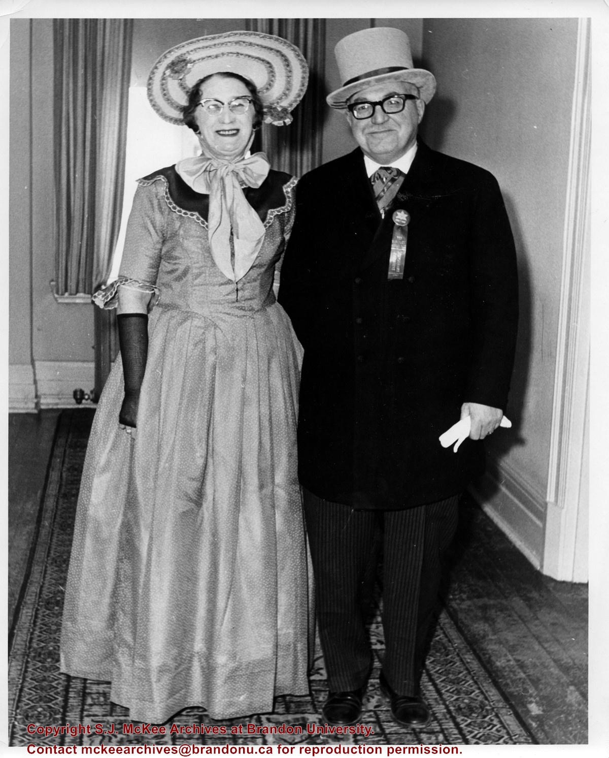
Item is a photograph of Mayor Stephen Magnacca and his wife Grace Magnacca dressed in period costumes for Canada's Centennial in 1967.
Notes
History/Bio information taken from the Manitoba Historical Society website (http://www.mhs.mb.ca/docs/people/magnacca_sa.shtml) and the December 31, 1969 Brandon Sun article Experience of being the wife of the mayor has brought satisfaction to Mrs. Magnacca.
Name Access
Stephen Magnacca
Grace Magnacca
Subject Access
celebrations
centennials
mayors
Storage Location
BAPC photograph drawer
Images
Show Less

19 records – page 1 of 1.