Skip header and navigation

Revise Search

16 records – page 1 of 1.

8th Street and Rosser Avenue intersection

http://archives.brandonu.ca/en/permalink/descriptions13701
Part Of
Fred McGuinness collection
Description Level
Item
GMD
graphic
Date Range
[1906]
Accession Number
20-2009
Part Of
Fred McGuinness collection
Description Level
Item
Series Number
McG 9
Item Number
20-2009.11
Accession Number
20-2009
GMD
graphic
Date Range
[1906]
Physical Description
6.5" x 4.25" (b/w)
Material Details
on matting
Physical Condition
Photograph is scratched and has been glued to a backing board that has warped over time
Scope and Content
Photograph shows street view of intersection of the 000 block of 8th Street and Rosser Avenue. Horse and buggies are travelling on both roads. Businesses on the east side of 8th Street from Pacific to Rosser Avenues are clearly visible and include: a Lunch Room (likely Aagaard's Lunch Counter), the Hotel Imperial Annex, Liverpool House (a boarding house), R.S. Thompson and Company Real Estate Office (Land Office), a barber shop (likely J. Coulter's), Frank Gowen photography studio, and Fleming's Drug Store. A possible street fair is in progress on Rosser Avenue. One man is surrounded by a crowd adjacent to the Fleming Block, another man stands on a soap box in the middle of the intersection, while a third man is standing behind a booth. Building construction appears to be happening on the west corner of 7th Street and Rosser Avenue.
Notes
Writing on the front of the photograph matting reads: 296. One photograph (20-2009.12) is glued above and two others are glued on the reverse side. Page appears to be from a photo album.
Name Access
Fleming Block
Fleming's Drug Store
Frank Gowen Photographer
Liverpool House
Hotel Imperial Annex
8th Street
Rosser Avenue
Aagaard's
R.S. Thompson
8th Street Bridge
Subject Access
Street scene
Transportation
downtown
storefronts
store exteriors
hotels
boarding houses
barber shops
restaurants
druggists
photographers
bridge
horses
dogs
land agents
Storage Location
RG 5 photograph storage drawer 2 (hanging photos)
Images
Show Less

8th Street and Rosser Avenue intersection

http://archives.brandonu.ca/en/permalink/descriptions13768
Part Of
Fred McGuinness collection
Description Level
Item
GMD
graphic
Date Range
[1906]
Accession Number
20-2009
Part Of
Fred McGuinness collection
Description Level
Item
Series Number
McG 9
Item Number
20-2009.79
Accession Number
20-2009
GMD
graphic
Date Range
[1906]
Physical Description
4.25" x 3.25" (b/w)
Material Details
on matting
Physical Condition
Photograph is scratched and has been glued to a backing board that has warped over time
Scope and Content
Photograph shows street view of the northeast intersection of the 000 block of 8th Street and Rosser Avenue. Horse and buggies are parked along the east side of 8th Street. Businesses on the east side of 8th Street from Pacific to Rosser Avenues are clearly visible and include: a Lunch Room (likely Aagaard's Lunch Counter), the Hotel Imperial Annex, Liverpool House (a boarding house), R.S. Thompson and Company Real Estate Office (Land Office), a barber shop (likely J. Coulter's), Frank Gowen photography studio, and Fleming's Drug Store. A possible street fair is in progress on Rosser Avenue. One man is standing on a soap box and is surrounded by a crowd in the middle of 8th Street. Another man can be seen standing behind a booth on the northwest street corner. Building construction appears to be happening on the west corner of 8th Street and Rosser Avenue.
Notes
Writing on the front of the photograph matting reads: 297. One photograph (20-2009.80) is glued below the photograph. Another photograph is glued on the reverse side. Page appears to be from a photo album.
Name Access
Fleming Block
Fleming's Drug Store
Frank Gowen Photographer
Liverpool House
Hotel Imperial Annex
8th Street
Rosser Avenue
Aagaard's
R.S. Thompson
8th Street Bridge
Subject Access
Street scene
Transportation
downtown
storefronts
store exteriors
hotels
boarding houses
barber shops
restaurants
druggists
photographers
bridge
horses
dogs
buggies
Storage Location
RG 5 photograph storage drawer 2 (hanging photos)
Images
Show Less

Assiniboine River; Treesbank Ferry - Stockton Ferry

http://archives.brandonu.ca/en/permalink/descriptions11023
Part Of
RG 11 Lawrence Stuckey fonds
Description Level
Item
GMD
graphic
Date Range
May 23, 1981
Part Of
RG 11 Lawrence Stuckey fonds
Creator
L.A. Stuckey
Description Level
Item
Series Number
3.3
Item Number
1-2002.3.3.BSE[362a]
GMD
graphic
Date Range
May 23, 1981
Physical Description
2.5" x 2.5"
Material Details
Negative
History / Biographical
Mr. Stuckey's notes: Jacques Wendover and Errol Bredin.
Custodial History
For custodial history see the collection level description of the Lawrence Stuckey collection.
Scope and Content
Image of Assiniboine River; Treesbank Ferry - Stockton Ferry.
Notes
[Brandon SE includes communities south of Trans-Canada #1 highway and east of PTH #10.]
Name Access
Assiniboine River
Stockton, Manitoba
Stockton Ferry
Treesbank Ferry
Jacques Wendover
Errol Bredin
Subject Access
ferries
Transportation
water transportation
ferry services
Rivers
Storage Location
Lawrence Stuckey collection
Arrangement
[Mr. Stuckey put four negatives in the same envelope. We have separated them and numbered the negatives (362a) to (362d)].
Images
Show Less

Assiniboine River; Treesbank Ferry - Stockton Ferry

http://archives.brandonu.ca/en/permalink/descriptions11024
Part Of
RG 11 Lawrence Stuckey fonds
Description Level
Item
GMD
graphic
Date Range
May 23, 1981
Part Of
RG 11 Lawrence Stuckey fonds
Creator
L.A. Stuckey
Description Level
Item
Series Number
3.3
Item Number
1-2002.3.3.BSE[362b]
GMD
graphic
Date Range
May 23, 1981
Physical Description
2.5" x 2.5"
Material Details
Negative
History / Biographical
Mr. Stuckey's notes: Jacques Wendover and Errol Bredin.
Custodial History
For custodial history see the collection level description of the Lawrence Stuckey collection.
Scope and Content
Image of Assiniboine River; Treesbank Ferry - Stockton Ferry.
Notes
[Brandon SE includes communities south of Trans-Canada #1 highway and east of PTH #10.]
Name Access
Assiniboine River
Stockton, Manitoba
Stockton Ferry
Treesbank Ferry
Jacques Wendover
Errol Bredin
Subject Access
ferries
Transportation
water transportation
ferry services
Rivers
Storage Location
Lawrence Stuckey collection
Arrangement
[Mr. Stuckey put four negatives in the same envelope. We have separated them and numbered the negatives (362a) to (362d)].
Images
Show Less

Assiniboine River; Treesbank Ferry - Stockton Ferry

http://archives.brandonu.ca/en/permalink/descriptions11025
Part Of
RG 11 Lawrence Stuckey fonds
Description Level
Item
GMD
graphic
Date Range
May 23, 1981
Part Of
RG 11 Lawrence Stuckey fonds
Creator
L.A. Stuckey
Description Level
Item
Series Number
3.3
Item Number
1-2002.3.3.BSE[362c]
GMD
graphic
Date Range
May 23, 1981
Physical Description
2.5" x 2.5"
Material Details
Negative
History / Biographical
Mr. Stuckey's notes: Jacques Wendover and Errol Bredin.
Custodial History
For custodial history see the collection level description of the Lawrence Stuckey collection.
Scope and Content
Image of Assiniboine River; Treesbank Ferry - Stockton Ferry.
Notes
[Brandon SE includes communities south of Trans-Canada #1 highway and east of PTH #10.]
Name Access
Assiniboine River
Stockton, Manitoba
Stockton Ferry
Treesbank Ferry
Jacques Wendover
Errol Bredin
Subject Access
ferries
Transportation
water transportation
ferry services
Rivers
Storage Location
Lawrence Stuckey collection
Arrangement
[Mr. Stuckey put four negatives in the same envelope. We have separated them and numbered the negatives (362a) to (362d)].
Images
Show Less

Assiniboine River; Treesbank Ferry - Stockton Ferry

http://archives.brandonu.ca/en/permalink/descriptions11026
Part Of
RG 11 Lawrence Stuckey fonds
Description Level
Item
GMD
graphic
Date Range
May 23, 1981
Part Of
RG 11 Lawrence Stuckey fonds
Creator
L.A. Stuckey
Description Level
Item
Series Number
3.3
Item Number
1-2002.3.3.BSE[362d]
GMD
graphic
Date Range
May 23, 1981
Physical Description
2.5" x 2.5"
Material Details
Negative
History / Biographical
Mr. Stuckey's notes: Jacques Wendover and Errol Bredin.
Custodial History
For custodial history see the collection level description of the Lawrence Stuckey collection.
Scope and Content
Image of Assiniboine River; Treesbank Ferry - Stockton Ferry.
Notes
[Brandon SE includes communities south of Trans-Canada #1 highway and east of PTH #10.]
Name Access
Assiniboine River
Stockton, Manitoba
Stockton Ferry
Treesbank Ferry
Jacques Wendover
Errol Bredin
Subject Access
ferries
Transportation
water transportation
ferry services
Rivers
Storage Location
Lawrence Stuckey collection
Arrangement
[Mr. Stuckey put four negatives in the same envelope. We have separated them and numbered the negatives (362a) to (362d)].
Images
Show Less
Part Of
CKX fonds
Description Level
Item
GMD
graphic
Date Range
after 1954
Accession Number
11-2010
Part Of
CKX fonds
Creator
CKX
Description Level
Item
Series Number
R
Item Number
11-2010.R52
Accession Number
11-2010
GMD
graphic
Date Range
after 1954
Physical Description
5" x 4" (b/w)
Material Details
Negative
Custodial History
See fonds level of the CKX records for custodial history.
Scope and Content
Portrait of Betty Reid.
Name Access
CKX
Betty Reid
Subject Access
portraits
persons
Storage Location
CKX fonds - 2010 accessions
Images
Show Less

Brandon train station

http://archives.brandonu.ca/en/permalink/descriptions14273
Part Of
Joseph H. Hughes collection
Description Level
Item
GMD
graphic
Date Range
[1905-1911]
Accession Number
3-1997
Part Of
Joseph H. Hughes collection
Creator
Photographer: Frank Gowen
Description Level
Item
Series Number
3-1997.1
Item Number
3-1997.1.75
Accession Number
3-1997
Other Numbers
Hughes #71
GMD
graphic
Date Range
[1905-1911]
Physical Description
9.5" x 7.5" (b/w)
Material Details
on matting
Physical Condition
Photograph is stained
Scope and Content
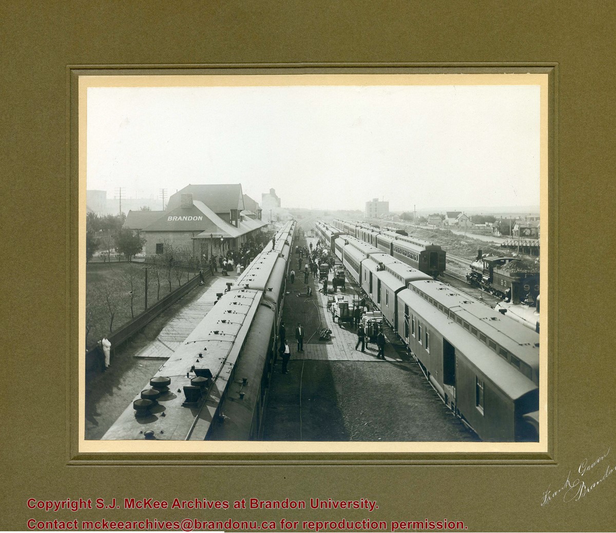
Photograph shows a CPR passenger trains at the old Brandon train station. Carts/trolleys appear to be loaded with wooden crates and metal milk containers. Photograph was likely taken from the 8th Street Bridge. The ramp to the 8th Street Bridge can be seen on the ride of the photograph, where residences line Assiniboine Avenue.
Name Access
Assiniboine Avenue - Early Scene
8th Street Bridge
Subject Access
residences
building exteriors
residential streets
railway stations
railroads
Storage Location
Hughes oversize drawer
Images
Show Less

Curries Landing (Assiniboine River)

http://archives.brandonu.ca/en/permalink/descriptions11132
Part Of
RG 11 Lawrence Stuckey fonds
Description Level
Item
GMD
graphic
Date Range
Apr. 12, 1977
Part Of
RG 11 Lawrence Stuckey fonds
Creator
L.A. Stuckey
Description Level
Item
Series Number
3.3
Item Number
1-2002.3.3.BSE[366a]
GMD
graphic
Date Range
Apr. 12, 1977
Physical Description
2.5" x 2.5"
Material Details
Negative
Custodial History
For custodial history see the collection level description of the Lawrence Stuckey collection.
Scope and Content
Image of Curries Landing (Assiniboine River).
Notes
[Brandon SE includes communities south of Trans-Canada #1 highway and east of PTH #10.]
Name Access
Curries Landing
Assiniboine River
Subject Access
Rivers
Storage Location
Lawrence Stuckey collection
Arrangement
[Mr. Stuckey put three negatives in the same envelope. We have separated them and numbered the negatives (366a) to(366c)].
Images
Show Less

Curries Landing (Assiniboine River)

http://archives.brandonu.ca/en/permalink/descriptions11134
Part Of
RG 11 Lawrence Stuckey fonds
Description Level
Item
GMD
graphic
Date Range
Apr. 12, 1977
Part Of
RG 11 Lawrence Stuckey fonds
Creator
L.A. Stuckey
Description Level
Item
Series Number
3.3
Item Number
1-2002.3.3.BSE[366b]
GMD
graphic
Date Range
Apr. 12, 1977
Physical Description
2.5" x 2.5"
Material Details
Negative
Custodial History
For custodial history see the collection level description of the Lawrence Stuckey collection.
Scope and Content
Image of Curries Landing (Assiniboine River).
Notes
[Brandon SE includes communities south of Trans-Canada #1 highway and east of PTH #10.]
Name Access
Curries Landing
Assiniboine River
Subject Access
Rivers
Storage Location
Lawrence Stuckey collection
Arrangement
[Mr. Stuckey put three negatives in the same envelope. We have separated them and numbered the negatives (366a) to(366c)].
Images
Show Less

Curries Landing (Assiniboine River)

http://archives.brandonu.ca/en/permalink/descriptions11135
Part Of
RG 11 Lawrence Stuckey fonds
Description Level
Item
GMD
graphic
Date Range
Apr. 12, 1977
Part Of
RG 11 Lawrence Stuckey fonds
Creator
L.A. Stuckey
Description Level
Item
Series Number
3.3
Item Number
1-2002.3.3.BSE[366c]
GMD
graphic
Date Range
Apr. 12, 1977
Physical Description
2.5" x 2.5"
Material Details
Negative
Custodial History
For custodial history see the collection level description of the Lawrence Stuckey collection.
Scope and Content
Image of Curries Landing (Assiniboine River).
Notes
[Brandon SE includes communities south of Trans-Canada #1 highway and east of PTH #10.]
Name Access
Curries Landing
Assiniboine River
Subject Access
Rivers
Storage Location
Lawrence Stuckey collection
Arrangement
[Mr. Stuckey put three negatives in the same envelope. We have separated them and numbered the negatives (366a) to(366c)].
Images
Show Less

Morning reflection of Brandon's skyline on the Assiniboine River

http://archives.brandonu.ca/en/permalink/descriptions13781
Part Of
Fred McGuinness collection
Description Level
Item
GMD
graphic
Date Range
[1980s]
Accession Number
20-2009
Part Of
Fred McGuinness collection
Creator
Photographer: Sandy Black
Description Level
Item
Series Number
McG 9
Item Number
20-2009.92
Accession Number
20-2009
GMD
graphic
Date Range
[1980s]
Physical Description
5.5" x 3.5" (colour)
Material Details
postcard
Scope and Content
Postcard shows the 100 block of 10th Street facing north. The CPR train station can be seen at the end of 10th Street. The sign for the Rex Cafe is visible on the west side of 10th Street. On the east side of 10th Street, billboards for Campbell & Campbell furniture are visible as well as signs for Pianos and the Orpheum Theatre. Motorists and cyclists share the road. Street car tracks run the length of 10th Street.
Notes
Back of postcard reads: Morning reflection of Brandon's skyline on the Assiniboine River, photo by Sandy Black, printed in Brandno, Manitoba, Canada by Leech Printing Ltd.
Name Access
Assiniboine River
McKenzie Seeds
Scotia Towers
Subject Access
Rivers
downtown
Storage Location
RG 5 photograph storage drawer 2 (hanging photos)
Images
Show Less
Part Of
CKX fonds
Description Level
Item
GMD
graphic
Date Range
after 1954
Accession Number
11-2010
Part Of
CKX fonds
Creator
CKX
Description Level
Item
Series Number
S
Item Number
11-2010.S116k
Accession Number
11-2010
GMD
graphic
Date Range
after 1954
Physical Description
5" x 4" (b/w)
Material Details
Negative
Custodial History
See fonds level of the CKX records for custodial history.
Scope and Content
Image of the Assiniboine River.
Name Access
CKX
Assiniboine River
Subject Access
winter
Rivers
bridges
building exteriors
trees
Storage Location
CKX fonds - 2010 accessions
Images
Show Less

Stockton Ferry, Stockton, Manitoba

http://archives.brandonu.ca/en/permalink/descriptions11022
Part Of
RG 11 Lawrence Stuckey fonds
Description Level
Item
GMD
graphic
Date Range
May 23, 1981
Part Of
RG 11 Lawrence Stuckey fonds
Creator
L.A. Stuckey
Description Level
Item
Series Number
3.3
Item Number
1-2002.3.3.BSE[361]
GMD
graphic
Date Range
May 23, 1981
Physical Description
2.5" x 2.5"
Material Details
Negative
Custodial History
For custodial history see the collection level description of the Lawrence Stuckey collection.
Notes
[Brandon SE includes communities south of Trans-Canada #1 highway and east of PTH #10.]
Name Access
Assiniboine River
Stockton, Manitoba
Stockton Ferry
Subject Access
ferries
Transportation
water transportation
ferry services
Rivers
Storage Location
Lawrence Stuckey collection
Images
Show Less

Street scene 8th Street in winter

http://archives.brandonu.ca/en/permalink/descriptions13703
Part Of
Fred McGuinness collection
Description Level
Item
GMD
graphic
Date Range
1906
Accession Number
20-2009
Part Of
Fred McGuinness collection
Description Level
Item
Series Number
McG 9
Item Number
20-2009.13
Accession Number
20-2009
GMD
graphic
Date Range
1906
Physical Description
4.25" x 3.25" (b/w)
Material Details
on matting
Physical Condition
Photograph has been glued to a backing board that has warped over time
History / Biographical
On 16 November 1906, Manitoba was hit by a severe winter storm that began that Thursday evening and extended through the weekend. The Brandon Daily Sun ("Storm Extends Over a Large Territory," 17 Nov. 1906, 1) reported that rail and telegraph services had been disrupted, country roads were impassable, and business in town was at a stand still. Following the weekend, the daily reported the blizzard was one of the greatest in recent memory. CPR trains had been caught in drifts by Carberry and an express car had caught fire and was destroyed ("Worst Storm in Many Years," Brandon Daily Sun, 19 Nov. 1906, 1).
Scope and Content
Photograph shows street view of intersection of the 000 block of 8th Street and Rosser Avenue in the winter. Businesses on the east side of 8th Street from Pacific to Rosser Avenues are clearly visible and include: a Lunch Room (likely Aagaard's Lunch Counter), the Hotel Imperial Annex, Liverpool House (a boarding house), R.S. Thompson and Company Real Estate Office (Land Office), a barber shop (likely J. Coulter's), Frank Gowen photography studio. Fleming's Drug Store on the corner of 8th Street and Rosser Avenue has been replaced by the Bank of Hamilton. The Imperial Hotel is visible on the west side of 8th Street. The 8th Street Bridge is visible in the background.
Notes
Writing on the front of the photograph matting reads: 338, November 1906. Page appears to be from a photo album. The photograph appears to be taken from the interior of a builing on the southwest corner of 8th Street and Rosser Avenue.
Name Access
Fleming Block
Frank Gowen Photographer
Liverpool House
Hotel Imperial Annex
8th Street
Rosser Avenue
Aagaard's
R.S. Thompson
8th Street Bridge
Bank of Hamilton
Imperial Hotel
Subject Access
Street scene
downtown
storefronts
store exteriors
hotels
boarding houses
barber shops
restaurants
druggists
photographers
bridge
banks
winter
land agents
Storage Location
RG 5 photograph storage drawer 2 (hanging photos)
Images
Show Less

Street scene 8th Street in winter

http://archives.brandonu.ca/en/permalink/descriptions13704
Part Of
Fred McGuinness collection
Description Level
Item
GMD
graphic
Date Range
1906
Accession Number
20-2009
Part Of
Fred McGuinness collection
Description Level
Item
Series Number
McG 9
Item Number
20-2009.14
Accession Number
20-2009
GMD
graphic
Date Range
1906
Physical Description
4.25" x 3.25" (b/w)
Material Details
on matting
Physical Condition
Photograph has been glued to a backing board that has warped over time
History / Biographical
On 16 November 1906, Manitoba was hit by a severe winter storm that began that Thursday evening and extended through the weekend. The Brandon Daily Sun ("Storm Extends Over a Large Territory," 17 Nov. 1906, 1) reported that rail and telegraph services had been disrupted, country roads were impassable, and business in town was at a stand still. Following the weekend, the daily reported the blizzard was one of the greatest in recent memory. CPR trains had been caught in drifts by Carberry and an express car had caught fire and was destroyed ("Worst Storm in Many Years," Brandon Daily Sun, 19 Nov. 1906, 1).
Scope and Content
Photograph shows street view of intersection of the 000 block of 8th Street and Rosser Avenue in the winter. Businesses on the east side of 8th Street from Pacific to Rosser Avenues are clearly visible and include: a Lunch Room (likely Aagaard's Lunch Counter), the Hotel Imperial Annex, Liverpool House (a boarding house), R.S. Thompson and Company Real Estate Office (Land Office), a barber shop (likely J. Coulter's), Frank Gowen photography studio. Fleming's Drug Store on the corner of 8th Street and Rosser Avenue has been replaced by the Bank of Hamilton. The Imperial Hotel is visible on the west side of 8th Street. The 8th Street Bridge is visible in the background. Men in winter coats and hats are crossing the street at the intersection. A horse-drawn sleigh is parked on 8th Street.
Notes
Writing on the front of the photograph matting reads: 340, after the storm November 1906. Page appears to be from a photo album. The photograph appears to be taken from the interior of a builing on the southwest corner of 8th Street and Rosser Avenue.
Name Access
Fleming Block
Frank Gowen Photographer
Liverpool House
Hotel Imperial Annex
8th Street
Rosser Avenue
Aagaard's
R.S. Thompson
8th Street Bridge
Bank of Hamilton
Imperial Hotel
Subject Access
Street scene
downtown
storefronts
store exteriors
hotels
boarding houses
barber shops
restaurants
druggists
photographers
bridges
banks
winter
Transportation
sleighs
storms
land agents
Storage Location
RG 5 photograph storage drawer 2 (hanging photos)
Images
Show Less

16 records – page 1 of 1.