Skip header and navigation

Revise Search

14 records – page 1 of 1.

Assiniboine River; Treesbank Ferry - Stockton Ferry

http://archives.brandonu.ca/en/permalink/descriptions11023
Part Of
RG 11 Lawrence Stuckey fonds
Description Level
Item
GMD
graphic
Date Range
May 23, 1981
Part Of
RG 11 Lawrence Stuckey fonds
Creator
L.A. Stuckey
Description Level
Item
Series Number
3.3
Item Number
1-2002.3.3.BSE[362a]
GMD
graphic
Date Range
May 23, 1981
Physical Description
2.5" x 2.5"
Material Details
Negative
History / Biographical
Mr. Stuckey's notes: Jacques Wendover and Errol Bredin.
Custodial History
For custodial history see the collection level description of the Lawrence Stuckey collection.
Scope and Content
Image of Assiniboine River; Treesbank Ferry - Stockton Ferry.
Notes
[Brandon SE includes communities south of Trans-Canada #1 highway and east of PTH #10.]
Name Access
Assiniboine River
Stockton, Manitoba
Stockton Ferry
Treesbank Ferry
Jacques Wendover
Errol Bredin
Subject Access
ferries
Transportation
water transportation
ferry services
Rivers
Storage Location
Lawrence Stuckey collection
Arrangement
[Mr. Stuckey put four negatives in the same envelope. We have separated them and numbered the negatives (362a) to (362d)].
Images
Show Less

Assiniboine River; Treesbank Ferry - Stockton Ferry

http://archives.brandonu.ca/en/permalink/descriptions11024
Part Of
RG 11 Lawrence Stuckey fonds
Description Level
Item
GMD
graphic
Date Range
May 23, 1981
Part Of
RG 11 Lawrence Stuckey fonds
Creator
L.A. Stuckey
Description Level
Item
Series Number
3.3
Item Number
1-2002.3.3.BSE[362b]
GMD
graphic
Date Range
May 23, 1981
Physical Description
2.5" x 2.5"
Material Details
Negative
History / Biographical
Mr. Stuckey's notes: Jacques Wendover and Errol Bredin.
Custodial History
For custodial history see the collection level description of the Lawrence Stuckey collection.
Scope and Content
Image of Assiniboine River; Treesbank Ferry - Stockton Ferry.
Notes
[Brandon SE includes communities south of Trans-Canada #1 highway and east of PTH #10.]
Name Access
Assiniboine River
Stockton, Manitoba
Stockton Ferry
Treesbank Ferry
Jacques Wendover
Errol Bredin
Subject Access
ferries
Transportation
water transportation
ferry services
Rivers
Storage Location
Lawrence Stuckey collection
Arrangement
[Mr. Stuckey put four negatives in the same envelope. We have separated them and numbered the negatives (362a) to (362d)].
Images
Show Less

Assiniboine River; Treesbank Ferry - Stockton Ferry

http://archives.brandonu.ca/en/permalink/descriptions11025
Part Of
RG 11 Lawrence Stuckey fonds
Description Level
Item
GMD
graphic
Date Range
May 23, 1981
Part Of
RG 11 Lawrence Stuckey fonds
Creator
L.A. Stuckey
Description Level
Item
Series Number
3.3
Item Number
1-2002.3.3.BSE[362c]
GMD
graphic
Date Range
May 23, 1981
Physical Description
2.5" x 2.5"
Material Details
Negative
History / Biographical
Mr. Stuckey's notes: Jacques Wendover and Errol Bredin.
Custodial History
For custodial history see the collection level description of the Lawrence Stuckey collection.
Scope and Content
Image of Assiniboine River; Treesbank Ferry - Stockton Ferry.
Notes
[Brandon SE includes communities south of Trans-Canada #1 highway and east of PTH #10.]
Name Access
Assiniboine River
Stockton, Manitoba
Stockton Ferry
Treesbank Ferry
Jacques Wendover
Errol Bredin
Subject Access
ferries
Transportation
water transportation
ferry services
Rivers
Storage Location
Lawrence Stuckey collection
Arrangement
[Mr. Stuckey put four negatives in the same envelope. We have separated them and numbered the negatives (362a) to (362d)].
Images
Show Less

Assiniboine River; Treesbank Ferry - Stockton Ferry

http://archives.brandonu.ca/en/permalink/descriptions11026
Part Of
RG 11 Lawrence Stuckey fonds
Description Level
Item
GMD
graphic
Date Range
May 23, 1981
Part Of
RG 11 Lawrence Stuckey fonds
Creator
L.A. Stuckey
Description Level
Item
Series Number
3.3
Item Number
1-2002.3.3.BSE[362d]
GMD
graphic
Date Range
May 23, 1981
Physical Description
2.5" x 2.5"
Material Details
Negative
History / Biographical
Mr. Stuckey's notes: Jacques Wendover and Errol Bredin.
Custodial History
For custodial history see the collection level description of the Lawrence Stuckey collection.
Scope and Content
Image of Assiniboine River; Treesbank Ferry - Stockton Ferry.
Notes
[Brandon SE includes communities south of Trans-Canada #1 highway and east of PTH #10.]
Name Access
Assiniboine River
Stockton, Manitoba
Stockton Ferry
Treesbank Ferry
Jacques Wendover
Errol Bredin
Subject Access
ferries
Transportation
water transportation
ferry services
Rivers
Storage Location
Lawrence Stuckey collection
Arrangement
[Mr. Stuckey put four negatives in the same envelope. We have separated them and numbered the negatives (362a) to (362d)].
Images
Show Less
Part Of
CKX fonds
Description Level
Item
GMD
graphic
Date Range
after 1954
Accession Number
11-2010
Part Of
CKX fonds
Creator
CKX
Description Level
Item
Series Number
R
Item Number
11-2010.R52
Accession Number
11-2010
GMD
graphic
Date Range
after 1954
Physical Description
5" x 4" (b/w)
Material Details
Negative
Custodial History
See fonds level of the CKX records for custodial history.
Scope and Content
Portrait of Betty Reid.
Name Access
CKX
Betty Reid
Subject Access
portraits
persons
Storage Location
CKX fonds - 2010 accessions
Images
Show Less

Coombs & Stewart general store c. 1881

http://archives.brandonu.ca/en/permalink/descriptions13756
Part Of
Fred McGuinness collection
Description Level
Item
GMD
graphic
Date Range
c.1881
Accession Number
20-2009
Part Of
Fred McGuinness collection
Description Level
Item
Series Number
McG 9
Item Number
20-2009.67
Accession Number
20-2009
GMD
graphic
Date Range
c.1881
Physical Description
6.5" x 5" (b/w)
Material Details
on matting
Physical Condition
Photograph is stained and water damaged. A newspaper clipping about William (Billy) Muir is glued to the top left hand corner of the mat. The image is exfoliated in the right hand corner. The negative has been reverse printed.
History / Biographical
Coombs & Stewart opened the first general store in Brandon in 1881, which was located on 6th Street and Pacific Avenue. According to G.F. Barker (Brandon: A City, 1977, 291), William (Billy) Muir worked at the store until he opened his own grocery store in 1888.
Custodial History
Donated to Fred McGuinness by Allena Strath (nee Coombs).
Scope and Content
Photograph shows the Coombs & Stewart general store located on the corner of Pacific Avenue and 6th Street. A group of men pose in front of the wood-framed store.
Notes
Back of photograph reads: One of first stores in Brandon, Coombs...[?]
Name Access
Coombs & Stewart
Pacific Avenue
6th Street
Wm. Muir General Grocer
Subject Access
Pioneers
general stores
building exteriors
store exteriors
horses
grocery stores
Brandon business buildings & facilities before 1940
Storage Location
RG 5 photograph storage drawer 2 (hanging photos)
Related Material
Lawrence Stuckey collection 1-2002.3.1E13
Images
Show Less

Curries Landing (Assiniboine River)

http://archives.brandonu.ca/en/permalink/descriptions11132
Part Of
RG 11 Lawrence Stuckey fonds
Description Level
Item
GMD
graphic
Date Range
Apr. 12, 1977
Part Of
RG 11 Lawrence Stuckey fonds
Creator
L.A. Stuckey
Description Level
Item
Series Number
3.3
Item Number
1-2002.3.3.BSE[366a]
GMD
graphic
Date Range
Apr. 12, 1977
Physical Description
2.5" x 2.5"
Material Details
Negative
Custodial History
For custodial history see the collection level description of the Lawrence Stuckey collection.
Scope and Content
Image of Curries Landing (Assiniboine River).
Notes
[Brandon SE includes communities south of Trans-Canada #1 highway and east of PTH #10.]
Name Access
Curries Landing
Assiniboine River
Subject Access
Rivers
Storage Location
Lawrence Stuckey collection
Arrangement
[Mr. Stuckey put three negatives in the same envelope. We have separated them and numbered the negatives (366a) to(366c)].
Images
Show Less

Curries Landing (Assiniboine River)

http://archives.brandonu.ca/en/permalink/descriptions11134
Part Of
RG 11 Lawrence Stuckey fonds
Description Level
Item
GMD
graphic
Date Range
Apr. 12, 1977
Part Of
RG 11 Lawrence Stuckey fonds
Creator
L.A. Stuckey
Description Level
Item
Series Number
3.3
Item Number
1-2002.3.3.BSE[366b]
GMD
graphic
Date Range
Apr. 12, 1977
Physical Description
2.5" x 2.5"
Material Details
Negative
Custodial History
For custodial history see the collection level description of the Lawrence Stuckey collection.
Scope and Content
Image of Curries Landing (Assiniboine River).
Notes
[Brandon SE includes communities south of Trans-Canada #1 highway and east of PTH #10.]
Name Access
Curries Landing
Assiniboine River
Subject Access
Rivers
Storage Location
Lawrence Stuckey collection
Arrangement
[Mr. Stuckey put three negatives in the same envelope. We have separated them and numbered the negatives (366a) to(366c)].
Images
Show Less

Curries Landing (Assiniboine River)

http://archives.brandonu.ca/en/permalink/descriptions11135
Part Of
RG 11 Lawrence Stuckey fonds
Description Level
Item
GMD
graphic
Date Range
Apr. 12, 1977
Part Of
RG 11 Lawrence Stuckey fonds
Creator
L.A. Stuckey
Description Level
Item
Series Number
3.3
Item Number
1-2002.3.3.BSE[366c]
GMD
graphic
Date Range
Apr. 12, 1977
Physical Description
2.5" x 2.5"
Material Details
Negative
Custodial History
For custodial history see the collection level description of the Lawrence Stuckey collection.
Scope and Content
Image of Curries Landing (Assiniboine River).
Notes
[Brandon SE includes communities south of Trans-Canada #1 highway and east of PTH #10.]
Name Access
Curries Landing
Assiniboine River
Subject Access
Rivers
Storage Location
Lawrence Stuckey collection
Arrangement
[Mr. Stuckey put three negatives in the same envelope. We have separated them and numbered the negatives (366a) to(366c)].
Images
Show Less

Morning reflection of Brandon's skyline on the Assiniboine River

http://archives.brandonu.ca/en/permalink/descriptions13781
Part Of
Fred McGuinness collection
Description Level
Item
GMD
graphic
Date Range
[1980s]
Accession Number
20-2009
Part Of
Fred McGuinness collection
Creator
Photographer: Sandy Black
Description Level
Item
Series Number
McG 9
Item Number
20-2009.92
Accession Number
20-2009
GMD
graphic
Date Range
[1980s]
Physical Description
5.5" x 3.5" (colour)
Material Details
postcard
Scope and Content
Postcard shows the 100 block of 10th Street facing north. The CPR train station can be seen at the end of 10th Street. The sign for the Rex Cafe is visible on the west side of 10th Street. On the east side of 10th Street, billboards for Campbell & Campbell furniture are visible as well as signs for Pianos and the Orpheum Theatre. Motorists and cyclists share the road. Street car tracks run the length of 10th Street.
Notes
Back of postcard reads: Morning reflection of Brandon's skyline on the Assiniboine River, photo by Sandy Black, printed in Brandno, Manitoba, Canada by Leech Printing Ltd.
Name Access
Assiniboine River
McKenzie Seeds
Scotia Towers
Subject Access
Rivers
downtown
Storage Location
RG 5 photograph storage drawer 2 (hanging photos)
Images
Show Less

Royal George Hotel

http://archives.brandonu.ca/en/permalink/descriptions13712
Part Of
Fred McGuinness collection
Description Level
Item
GMD
graphic
Date Range
1912
Accession Number
20-2009
Part Of
Fred McGuinness collection
Description Level
Item
Series Number
McG 9
Item Number
20-2009.22
Accession Number
20-2009
GMD
graphic
Date Range
1912
Physical Description
9.75" x 7.5" (b/w)
Physical Condition
photograph is torn and has scotch tape residue
Scope and Content
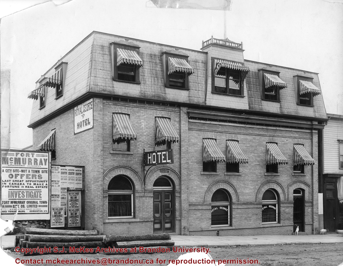
Photograph shows the exterior of the Royal George Hotel located at 142-6th Street, Brandon. Striped awnings cover the second and third storey windows of the hotel. Dogs roam the sidewalk in front of the hotel. Advertisements cover the fence adjacent to the hotel and include: Fort McMurray town site settlement; Mortgage sale for city property; Starland Theatre featuring Miss Amy Lawrence, Soprano; Sherman Theatre; 15th Annual Horticultural Exhibition
Notes
Date ascertained from 15th Annual Horticultural Exhibition advertisement posted on fence adjacent to hotel. Address obtained from Henderson's Brandon City Directory for 1913.
Name Access
Royal George Hotel
Starland Theatre
Sherman Theatre
Horticultural Exhibition
6th Street
Subject Access
hotels
building exteriors
advertising
dogs
Storage Location
RG 5 photograph storage drawer 2 (hanging photos)
Images
Show Less
Part Of
CKX fonds
Description Level
Item
GMD
graphic
Date Range
after 1954
Accession Number
11-2010
Part Of
CKX fonds
Creator
CKX
Description Level
Item
Series Number
S
Item Number
11-2010.S116k
Accession Number
11-2010
GMD
graphic
Date Range
after 1954
Physical Description
5" x 4" (b/w)
Material Details
Negative
Custodial History
See fonds level of the CKX records for custodial history.
Scope and Content
Image of the Assiniboine River.
Name Access
CKX
Assiniboine River
Subject Access
winter
Rivers
bridges
building exteriors
trees
Storage Location
CKX fonds - 2010 accessions
Images
Show Less

Stockton Ferry, Stockton, Manitoba

http://archives.brandonu.ca/en/permalink/descriptions11022
Part Of
RG 11 Lawrence Stuckey fonds
Description Level
Item
GMD
graphic
Date Range
May 23, 1981
Part Of
RG 11 Lawrence Stuckey fonds
Creator
L.A. Stuckey
Description Level
Item
Series Number
3.3
Item Number
1-2002.3.3.BSE[361]
GMD
graphic
Date Range
May 23, 1981
Physical Description
2.5" x 2.5"
Material Details
Negative
Custodial History
For custodial history see the collection level description of the Lawrence Stuckey collection.
Notes
[Brandon SE includes communities south of Trans-Canada #1 highway and east of PTH #10.]
Name Access
Assiniboine River
Stockton, Manitoba
Stockton Ferry
Subject Access
ferries
Transportation
water transportation
ferry services
Rivers
Storage Location
Lawrence Stuckey collection
Images
Show Less

William Muir General Grocer building

http://archives.brandonu.ca/en/permalink/descriptions13757
Part Of
Fred McGuinness collection
Description Level
Item
GMD
graphic
Date Range
post-1888
Accession Number
20-2009
Part Of
Fred McGuinness collection
Description Level
Item
Series Number
McG 9
Item Number
20-2009.68
Accession Number
20-2009
GMD
graphic
Date Range
post-1888
Physical Description
4.5" x 7.5" (b/w)
Material Details
on matting
Physical Condition
Matting is bent and has a thumbtack hole.
History / Biographical
According to G.F. Barker (Brandon: A City, 1977, 291), William (Billy) Muir worked at Coombs & Stewart's on Pacific Avenue until he opened his own grocery store in 1888. The shop was located at 143-6th Street, Brandon, and was demolished for a parking lot in 1952.
Custodial History
Donated to Fred McGuinness by Allena Strath (nee Coombs).
Scope and Content
Photograph shows the "Wm. Muir General Grocer" building on 6th Street. Two men pose in the doorway of the store. The man on the left is likely William Muir. Barrels are lined on the boardwalk in front of the store. Apples and mason jars can be seen in the shop's windows.
Notes
Front of photograph reads: Sixth Street between Rosser - Princess. Back of photograph reads: Billy Muir's Store, 143 6th Street Brandon - 57 years in business in this location. An address label affixed to the back of the mat reads: Mrs. James Strath, Box 421, Souris, Man.
Name Access
Coombs & Stewart
Pacific Avenue
6th Street
Wm. Muir General Grocer
Subject Access
Pioneers
general stores
building exteriors
store exteriors
grocery stores
Brandon business buildings & facilities before 1940
Storage Location
RG 5 photograph storage drawer 2 (hanging photos)
Related Material
Lawrence Stuckey collection 1-2002.3.1E18
Images
Show Less

14 records – page 1 of 1.