Photograph is scratched and has been glued to a backing board that has warped over time
Scope and Content
Photograph shows street view of intersection of the 000 block of 8th Street and Rosser Avenue. Horse and buggies are travelling on both roads. Businesses on the east side of 8th Street from Pacific to Rosser Avenues are clearly visible and include: a Lunch Room (likely Aagaard's Lunch Counter), the Hotel Imperial Annex, Liverpool House (a boarding house), R.S. Thompson and Company Real Estate Office (Land Office), a barber shop (likely J. Coulter's), Frank Gowen photography studio, and Fleming's Drug Store. A possible street fair is in progress on Rosser Avenue. One man is surrounded by a crowd adjacent to the Fleming Block, another man stands on a soap box in the middle of the intersection, while a third man is standing behind a booth. Building construction appears to be happening on the west corner of 7th Street and Rosser Avenue.
Notes
Writing on the front of the photograph matting reads: 296. One photograph (20-2009.12) is glued above and two others are glued on the reverse side. Page appears to be from a photo album.
Photograph is scratched and has been glued to a backing board that has warped over time
Scope and Content
Photograph shows street view of the northeast intersection of the 000 block of 8th Street and Rosser Avenue. Horse and buggies are parked along the east side of 8th Street. Businesses on the east side of 8th Street from Pacific to Rosser Avenues are clearly visible and include: a Lunch Room (likely Aagaard's Lunch Counter), the Hotel Imperial Annex, Liverpool House (a boarding house), R.S. Thompson and Company Real Estate Office (Land Office), a barber shop (likely J. Coulter's), Frank Gowen photography studio, and Fleming's Drug Store. A possible street fair is in progress on Rosser Avenue. One man is standing on a soap box and is surrounded by a crowd in the middle of 8th Street. Another man can be seen standing behind a booth on the northwest street corner. Building construction appears to be happening on the west corner of 8th Street and Rosser Avenue.
Notes
Writing on the front of the photograph matting reads: 297. One photograph (20-2009.80) is glued below the photograph. Another photograph is glued on the reverse side. Page appears to be from a photo album.
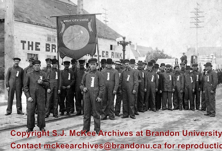
July 12 Orange Lodge parade in progress; Shows that there was a building in what was for many years, a small vacant lot behind the Bank of Montreal; Campbell & Campbell building and Security Block. Davidson (photography) Studio on awning - became Henfries studio and, in 1923, Jerrets' Studio.
Custodial History
For custodial history see the collection level description of the Lawrence Stuckey collection.
Scope and Content
100 Block of Tenth Street
Notes
Probably taken from Strathcona Block
Creator provided by Fred McGuinness collection (20-2009).
Postcard shows an aerial view of the city of Brandon
Notes
Writing on the back of the postcard reads: No. 10. Brandon, Manitoba, Canada / Aerial View of Brandon / Distributed by Clements Drug Store / Brandon, Manitoba, Canada / Photos by: R.J. "Bob" Snazel. / Printed by: D.W. Friesen & Sons Ltd. Altona, Manitoba, Canada. The postcard is addressed to Mr. F.A. Rosser and is postmarked Brandon 30 May 1970. A 6-cent Queen Elizabeth red postage stamp portraying various modes of the transportation. The stamp has been cancelled with a postmark that reads "Help Retarded Children."
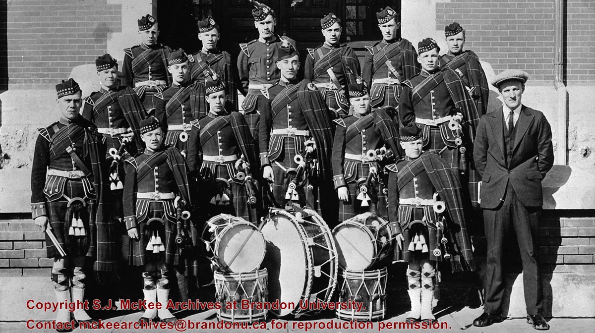
[The organization of the boys' pipe band was initiated by a group of citizens of Scottish origin in 1934. The same group engaged an instructor for the band from Scotland; the kilts were discovered in Park School and permission was given by the School Board for their use by the band.]
Custodial History
For custodial history see the collection level description of the Lawrence Stuckey collection.
Scope and Content
Brandon Boys Pipe Band
Notes
[History/Bio information is from Mary Hume's Brandon: A Prospect of a City, p. 129.]
For custodial history see the collection level description of the Lawrence Stuckey collection.
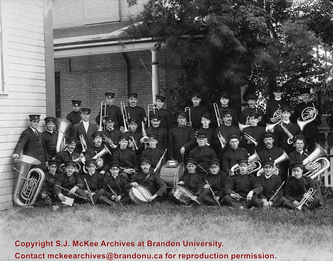
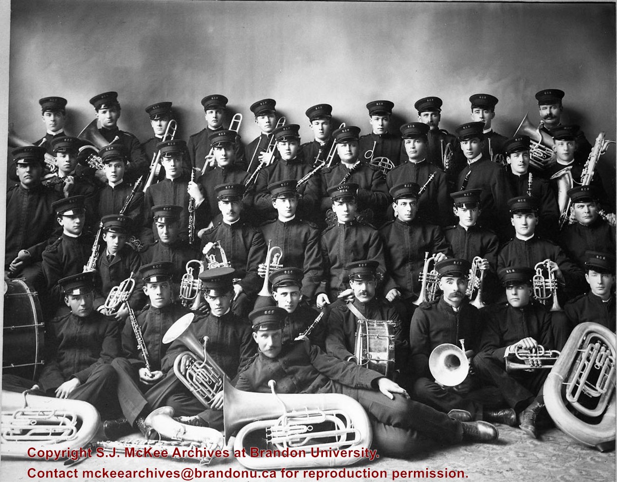
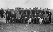
Scope and Content
Brandon City Band
Notes
Top row (l-r): F. Scott, A. McPhail, W. Marshall, L. Neilly, W. Lemay, W.G. Stuckey, W. Murdock, A. Smith, W. McLean, R. Barrett. 2nd row: W. Graham, M. Parkin, B. Treherne, J. Whitney, Geo. Mutter, L. Hammell, T. Rife, E. Rife, L. Purdon, E. Mathewson, J. Scott. 3rd row: J. Ober, A. Ober, F. Lepard, T. Mathewson, Paul Joubert, T.H. Miller, T.H. Farrar, E. Teeple, F. Harriet, F.A. Lewis. Bottom row: B. Neumeyer, Frank Parks, O. Olson, H. Lepard, W. Broadie, G. Sherman, B.T. Stuckey, Gordon Sampson, Frank Harris. T.H. Miller was band leader, W. Graham was secretary. A.C. Davidson was also a member but does not appear because he was the professional photographer; From George Lepard.
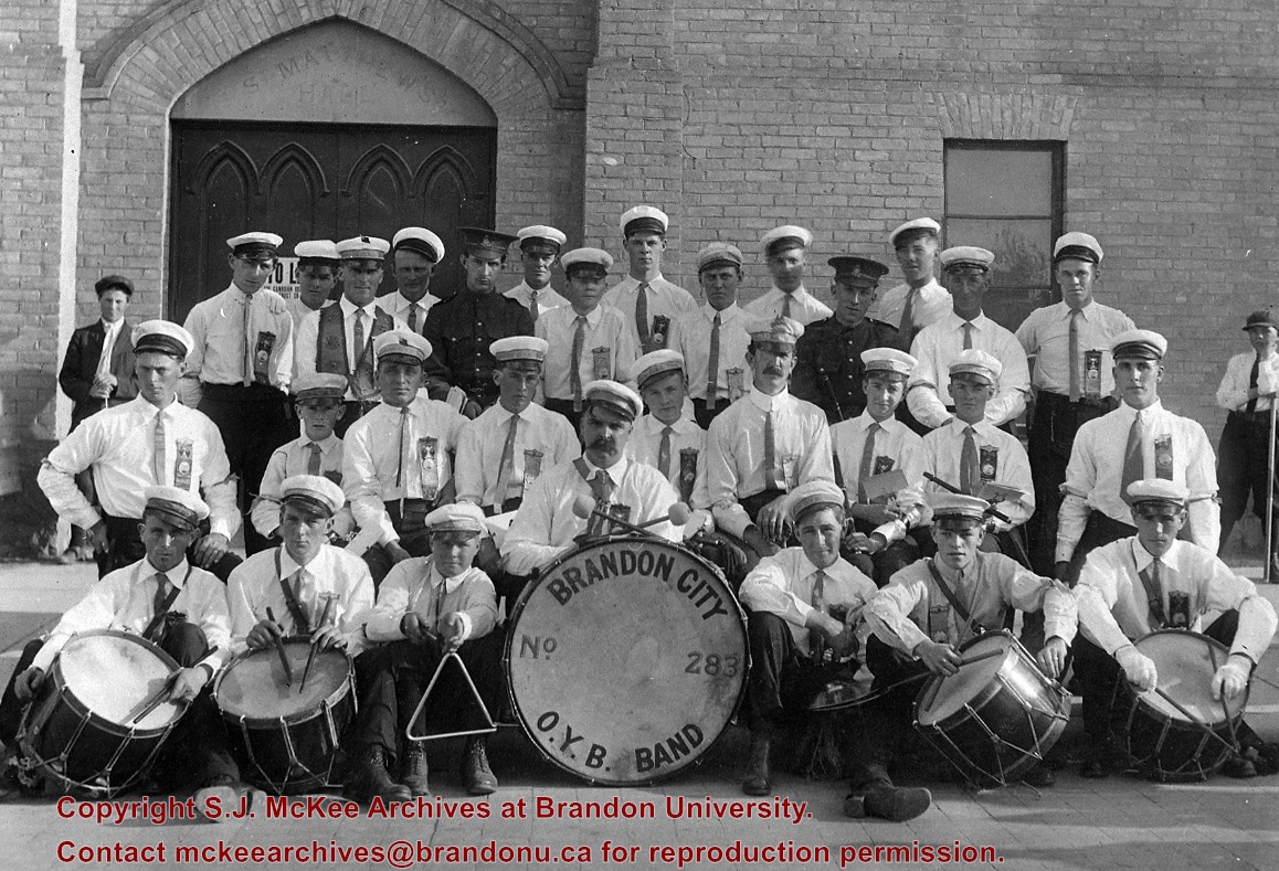
For custodial history see the collection level description of the Lawrence Stuckey collection.
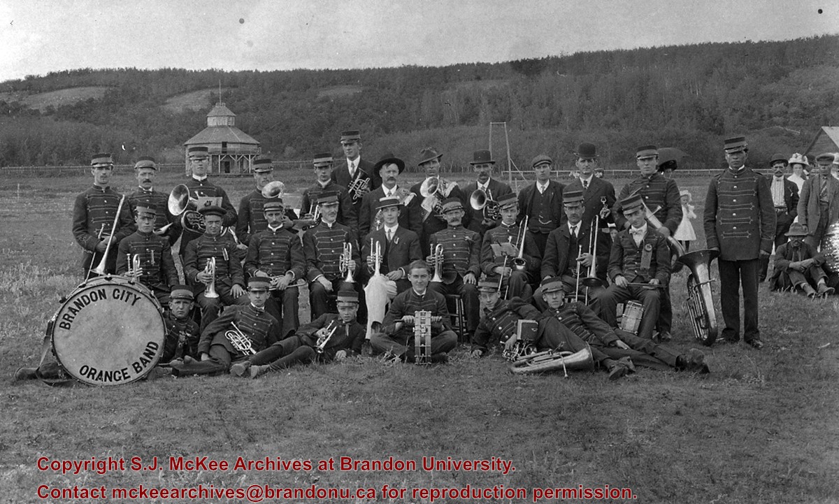
Scope and Content
Brandon City O.Y.B. Band
Notes
Names written on a piece of paper inside the envelope are now on the label. Top row (l-r): (boy), ?, Arnold Rice, Frank Roberts, Jack Pritchard, Tom Prue, ?, ?, Ab. Scott, ?, ?, Anthony Rogerson, ?, Bill Fisher, Al. Crane, (boy). 2nd row: Angus Munroe, Harry McKenzie, Adam Petrick, ?, Cec. Arthur, Alex. Pue (band leader), Temp. Roberts, Jack Melhuish, Dan Craig. 3rd row: ?, ?, Gordon Rice, Harry Wells (drummer), Roy Rice, W. Hayward, Bill McRory; Source: Mr. P.K. Roberts
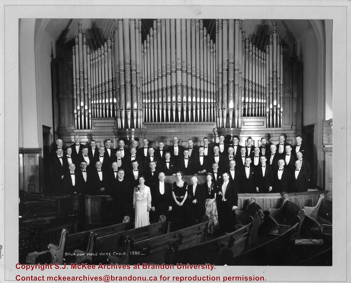
According to Henderson's 1935 Brandon City Directory, the First United Church was located on the corner of 8th Street and Lorne Avenue. The minister at the time was Reverend John H. Garden.
Scope and Content
Photograph shows the Brandon Male Voice Choir dressed in tuxedos and posing before the First United Church's pipe organ. A minister (possibly Rev. John H. Garden) and three women in formal attire are standing in the front row.
Notes
Writing on the back of the photograph reads: return to Bob Hoffman, Box #1, Brandon, R7A 5Y6
The Medicine Hat Exhibition and Stampede Parade Day was held on Thursday, July 19, 1962, at 9:30 a.m. The local newspaper reported that approximately 24,000 people were in attendance to see parade marshall Rod Ashburner leading 175 entries consisting of 90 floats, 75 horses, and 10 bands. There were 19 parade categories eligible for $12,000 in prize money and included: junior and senior cowboys and cowgirls; fancy and Shetland ponies; sulky class open; comic, commercial, industrial and organizational floats; decorated cars; special ranch class; 4-H Clubs; and a non-competitive class.
The parade route started at Second St. and Allowance Ave., from Second St. to Ash Ave., north on Ash to First St. SE., from First St. S.E. to Fourth Ave., south to Second St. to South Railway St., south on South Railway St. to Third St., with a finish at McLeod Trail. A route map was published in the Medicine Hat News the day before the parade.
Aerial photographs of the parade were taken by Medicine Hat News photographer Howard Heid (1930-2005) from the private helicopter of John Bourn. Bourn was a pilot from Woodville, Wisconsin, who chartered his four-seater helicopter for sight-seers at exhibitions and stampedes across the county.
(Sources: Pat Currie, "Let 'Er Go!," Medicine Hat News, 19 July 1962,1; Harald Gunderson, "'Eye in the Sky' Best Parade View," Medicine Hat News, 19 July 1962,1; "Parade Starts at 9:30 Sharp," 18 July 1962)
Scope and Content
Photograph shows an aerial view of the Medicine Hat Exhibition and Stampede Parade route with a focus on the First Street SE. A number of gas stations and garages are visible along this route and include Texaco, Shell, Ford, and B/A. The Fraternal Order of Eagles lodge is also visible.
Notes
This photograph appeared on the front page of The Medicine Hat News (19 July 1962).
The Medicine Hat Exhibition and Stampede Parade Day was held on Thursday, July 19, 1962, at 9:30 a.m. The local newspaper reported that approximately 24,000 people were in attendance to see parade marshall Rod Ashburner leading 175 entries consisting of 90 floats, 75 horses, and 10 bands. There were 19 parade categories eligible for $12,000 in prize money and included: junior and senior cowboys and cowgirls; fancy and Shetland ponies; sulky class open; comic, commercial, industrial and organizational floats; decorated cars; special ranch class; 4-H Clubs; and a non-competitive class.
The parade route started at Second St. and Allowance Ave., from Second St. to Ash Ave., north on Ash to First St. SE., from First St. S.E. to Fourth Ave., south to Second St. to South Railway St., south on South Railway St. to Third St., with a finish at McLeod Trail. A route map was published in the Medicine Hat News the day before the parade.
Aerial photographs of the parade were taken by Medicine Hat News photographer Howard Heid (1930-2005) from the private helicopter of John Bourn. Bourn was a pilot from Woodville, Wisconsin, who chartered his four-seater helicopter for sight-seers at exhibitions and stampedes across the county.
(Sources: Pat Currie, "Let 'Er Go!," Medicine Hat News, 19 July 1962,1; Harald Gunderson, "'Eye in the Sky' Best Parade View," Medicine Hat News, 19 July 1962,1; "Parade Starts at 9:30 Sharp," 18 July 1962)
Scope and Content
Photograph shows an aerial view of the Medicine Hat Exhibition and Stampede Parade route with a focus on the First Street SE and and the South Railway Street merge. A number of gas stations and garages are visible along this route and include Texaco, Shell, Ford, and B/A. The Fraternal Order of Eagles lodge is also visible.
Notes
This photograph shows the neighbourhood before rezoning and commercial development.


