Skip header and navigation

Revise Search

20 records – page 1 of 1.

2nd Floor Foyer, Library & Arts Opening

http://archives.brandonu.ca/en/permalink/descriptions30
Part Of
Brandon University Photograph Collection
Description Level
Item
Date Range
c. 1961
Part Of
Brandon University Photograph Collection
Description Level
Item
Series Number
1
File Number
1.1.16 A&B
Item Number
1.1.16 A&B
Date Range
c. 1961
Physical Description
b/w, A: 24.5 cm x 19 cm; B: 18.5 cm x 12.8 cm
Scope and Content
Furnishings, layouts and exhibits as at the time of opening. Allan Budlong (student), Barbara Ritchie (staff) Library Foyer, 2nd floor Library and Arts Building
Name Access
Allan Budlong; Barbara Ritchie
Subject Access
Library & Arts Building
Show Less

10th Street from Princess Avenue facing north, Brandon, Manitoba

http://archives.brandonu.ca/en/permalink/descriptions8402
Part Of
Joseph H. Hughes collection
Description Level
Item
GMD
graphic
Date Range
c. 1955
Accession Number
3-1997
Part Of
Joseph H. Hughes collection
Creator
Photographer: Jerrett Photo
Description Level
Item
Series Number
3-1997.1
Item Number
3-1997.1.24
Accession Number
3-1997
GMD
graphic
Date Range
c. 1955
Physical Description
3.5" x 5.5" (b/w)
Material Details
postcard
Physical Condition
good
Scope and Content
Photograph of 10th Street facing north from Princess Avenue. Vehicles are parallel parked on both sides of the street. The Welcome Brandon sign can be seen at the Rosser Avenue intersection. Visible businesses on the west side of 10th Street include: Doig's, Box Brothers Hardware and Allied Hardware Stores in the Alexandra Block; followed by Simpsons-Sears in the Strathcona Block. Barry Neill Men's Wear, Kresge's and the Cecil Hotel are also visible. The Johnny Smith Block is visible in the background. Visible businesses on the east side of 10th Street include: Ollies Steaks and Chops, Elna Sewing Centre, Carlton Cafe, Chop Suey. At the base of the hill the Canadian Pacific train station is visible at the base of the hill.
Notes
Writing on the front of the postcard reads: Tenth St. Brandon, Man.
Name Access
Strathcona Block
Alexandra Block
Doig's
Box Brothers Hardware
Simpsons-Sears Ltd.
Barry Neill Men's Wear
Kresge
Cecil Hotel
CPR Station
Ollies
Elna Sewing Centre
Carlton Cafe
10th Street
Subject Access
downtowns
street scenes
Brandon business buildings & facilities after 1940
building exteriors
Chinese restaurants
Storage Location
RG 5 photograph storage drawer
Images
Show Less

10th street power plant control room

http://archives.brandonu.ca/en/permalink/descriptions8764
Part Of
RG 11 Lawrence Stuckey fonds
Description Level
Item
GMD
graphic
Date Range
[n.d.]
Accession Number
1-2002
Part Of
RG 11 Lawrence Stuckey fonds
Creator
Clark J. Smith
Description Level
Item
Series Number
3.9
Item Number
1-2002.3.9.131
Accession Number
1-2002
GMD
graphic
Date Range
[n.d.]
Physical Description
8" x 10" (b/w)
Scope and Content
Photograph of the control room of the 10th Street Power Plant.
Repro Restriction
The McKee Archives is the copyright holder for the Stuckey materials.
Storage Location
RG 5 photograph storage drawer
Images
Show Less

10th street power plant control room

http://archives.brandonu.ca/en/permalink/descriptions8765
Part Of
RG 11 Lawrence Stuckey fonds
Description Level
Item
GMD
graphic
Date Range
[n.d.]
Accession Number
1-2002
Part Of
RG 11 Lawrence Stuckey fonds
Creator
Clark J. Smith
Description Level
Item
Series Number
3.9
Item Number
1-2002.3.9.132
Accession Number
1-2002
GMD
graphic
Date Range
[n.d.]
Physical Description
8" x 10" (b/w)
Scope and Content
Photograph of the control room of the 10th Street Power Plant.
Repro Restriction
The McKee Archives is the copyright holder for the Stuckey materials.
Storage Location
RG 5 photograph storage drawer
Images
Show Less

100-block 10th Street, facing southwest (2)

http://archives.brandonu.ca/en/permalink/descriptions8407
Part Of
Joseph H. Hughes collection
Description Level
Item
GMD
graphic
Date Range
c. 1950
Accession Number
3-1997
Part Of
Joseph H. Hughes collection
Description Level
Item
Series Number
3-1997.1
Item Number
3-1997.1.29
Accession Number
3-1997
GMD
graphic
Date Range
c. 1950
Physical Description
8 " x 10" (b/w)
Physical Condition
good
Scope and Content
Photograph shows the west side of 10th Street between Rosser and Princess Avenues. Visible businesses include: Recreation Bowling & Billiards, Bottomley's, Barry Neill Men's Wear, Simpsons-Sears, Allied Hardware Stores, Box Brothers Hardware, Doig's. Painted on the north face of the Strathcona Block are two advertisements, one for Sutherland and Robertson [Grocery] and the other for Boyd Electric Co. Ltd.
Name Access
10th Street
Recreation Bowling and Billiards
Bottomley's
Barry Neill Men's Wear
Simpsons-Sears Ltd.
Sutherland and Robertson
Boyd Electric Co. Ltd.
Strathcona Block
Box Brothers Hardware
Doig's
Allied Hardware
Alexandra Block
Subject Access
downtowns
street scenes
Brandon business buildings & facilities after 1940
building exteriors
Storage Location
RG 5 photograph storage drawer
Images
Show Less

100 Block of Tenth Street

http://archives.brandonu.ca/en/permalink/descriptions9201
Part Of
RG 11 Lawrence Stuckey fonds
Description Level
Item
GMD
graphic
Date Range
[ca. 1920]
Accession Number
1-2002
Part Of
RG 11 Lawrence Stuckey fonds
Creator
Clark J. Smith (?)
Description Level
Item
Series Number
3.1
Item Number
1-2002.3.1C13
Accession Number
1-2002
GMD
graphic
Date Range
[ca. 1920]
Physical Description
3 1/2" x 5"
Material Details
Negative
History / Biographical
July 12 Orange Lodge parade in progress; Shows that there was a building in what was for many years, a small vacant lot behind the Bank of Montreal; Campbell & Campbell building and Security Block. Davidson (photography) Studio on awning - became Henfries studio and, in 1923, Jerrets' Studio.
Custodial History
For custodial history see the collection level description of the Lawrence Stuckey collection.
Scope and Content
100 Block of Tenth Street
Notes
Probably taken from Strathcona Block
Creator provided by Fred McGuinness collection (20-2009).
Name Access
100 Block of Tenth Street
Subject Access
downtowns
businesses
organizations
fraternities
public ceremonies
parades
Brandon Street Scenes Before 1940
Repro Restriction
The McKee Archives is the copyright holder for the Stuckey materials.
Storage Location
Lawrence Stuckey collection
Images
Show Less

1000 block of Rosser Avenue

http://archives.brandonu.ca/en/permalink/descriptions9277
Part Of
RG 11 Lawrence Stuckey fonds
Description Level
Item
GMD
graphic
Date Range
April 13, 1975
Accession Number
1-2002
Part Of
RG 11 Lawrence Stuckey fonds
Creator
L.A. Stuckey
Description Level
Item
Series Number
3.1
Item Number
1-2002.3.1CA25(1)
Accession Number
1-2002
GMD
graphic
Date Range
April 13, 1975
Physical Description
2 1/2" x 2 1/2"
Material Details
Negative
Custodial History
For custodial history see the collection level description of the Lawrence Stuckey collection.
Scope and Content
1000 block of Rosser Ave., north side. Showing (left to right): Public Library (ex. Merchants Bank of Canada) built 1906; [Smith's Tobacco Shop,]; A.C. Fraser Block built 1890; Scotia Towers built 1970's.
Name Access
1000 Block of Rosser Avenue
Merchants Bank
Public Library
Chamber of Commerce
Smith's Tobacco
Fraser Block
Scotia Towers
Subject Access
downtowns
businesses
libraries
banks
chambers of commerce
Brandon Street Scenes After 1940
Repro Restriction
The McKee Archives is the copyright holder for the Stuckey materials.
Location Copy
1-2002.3.9.37
Storage Location
Lawrence Stuckey collection
Arrangement
[Mr. Stuckey put 2 negatives in the same envelope. We have separated them and numbered them CA25(1) and CA25(2).]
Images
Show Less

1000 block of Rosser Avenue

http://archives.brandonu.ca/en/permalink/descriptions9278
Part Of
RG 11 Lawrence Stuckey fonds
Description Level
Item
GMD
graphic
Date Range
April 13, 1975
Accession Number
1-2002
Part Of
RG 11 Lawrence Stuckey fonds
Creator
L.A. Stuckey
Description Level
Item
Series Number
3.1
Item Number
1-2002.3.1CA25(2)
Accession Number
1-2002
GMD
graphic
Date Range
April 13, 1975
Physical Description
2 1/2" x 2 1/2"
Material Details
Negative
Custodial History
For custodial history see the collection level description of the Lawrence Stuckey collection.
Scope and Content
1000 block of Rosser Ave., north side. Showing (left to right): Public Library (ex. Merchants Bank of Canada) built 1906; [Smith's Tobacco Shop,]; A.C. Fraser Block built 1890; Scotia Towers built 1970's.
Name Access
1000 Block of Rosser Avenue
Merchants Bank
Public Library
Chamber of Commerce
Smith's Tobacco
Fraser Block
Scotia Towers
Subject Access
downtowns
businesses
libraries
banks
chambers of commerce
Brandon Street Scenes After 1940
Repro Restriction
The McKee Archives is the copyright holder for the Stuckey materials.
Location Copy
1-2002.3.9.36
Storage Location
Lawrence Stuckey collection
Arrangement
[Mr. Stuckey put 2 negatives in the same envelope. We have separated them and numbered them CA25(1) and CA25(2).]
Images
Show Less

Accomodation (room & meals)

http://archives.brandonu.ca/en/permalink/descriptions3705
Part Of
RG 6 Brandon University fonds
Description Level
File
GMD
textual records
Date Range
1968-1970
Part Of
RG 6 Brandon University fonds
Description Level
File
Series Number
4.2
File Number
125
GMD
textual records
Date Range
1968-1970
Physical Description
1 file
Scope and Content
File consists of correspondence, applications for use of accomodation, the Brandon University catering service policy statement, and memos.
Storage Location
RG 6 Brandon University fonds Series 4: Office of the Vice-President 4.2 Office of the Vice-President (Administration & Finance) Box 4
Show Less

Aerial view: Brandon College campus from north

http://archives.brandonu.ca/en/permalink/descriptions615
Part Of
Aerial views and campus photographs
Description Level
Item
GMD
graphic
Date Range
c. 1963
Part Of
Aerial views and campus photographs
Description Level
Item
Series Number
2.1
Item Number
2.1.23
GMD
graphic
Date Range
c. 1963
Physical Description
5" x 4" (b/w)
Scope and Content
View is north, taken from approximatley 19th Street and Rosser Avenue. Photograph shows: Clark Hall, the A.E. McKenzie Building, the J.R.C. Evans Lecture Theatre, H-Huts, Darrach Hall and Flora Cowan Hall, as well as a number of homes in the area.
Images
Show Less

Aerial view: Brandon College campus looking northwest

http://archives.brandonu.ca/en/permalink/descriptions616
Part Of
Aerial views and campus photographs
Description Level
Item
GMD
graphic
Date Range
c. 1963
Part Of
Aerial views and campus photographs
Description Level
Item
Series Number
2.1
Item Number
2.1.24
GMD
graphic
Date Range
c. 1963
Physical Description
5" x 4" (b/w)
Scope and Content
View is northwest from approximately the corner of 18th Street and Louise Avenue. Photograph shows the Brandon College campus after the completion of Flora Cowan Hall.
Notes
BUPC 2.1.20 is a larger version of this photograph.
Images
Show Less

Aerial view: Brandon College looking east

http://archives.brandonu.ca/en/permalink/descriptions617
Part Of
Aerial views and campus photographs
Description Level
Item
GMD
graphic
Date Range
c. 1963
Part Of
Aerial views and campus photographs
Description Level
Item
Series Number
2.1
Item Number
2.1.25
GMD
graphic
Date Range
c. 1963
Physical Description
5" x 4" (b/w)
Scope and Content
View is east from approximatley 22nd Street between Lorne and Louise Avenues. Photograph shows: Darrach Hall, Flora Cowan Hall and the Citizens' Science Building, as well as a number of homes in the area.
Images
Show Less

Aerial view: Brandon College looking northwest

http://archives.brandonu.ca/en/permalink/descriptions599
Part Of
Aerial views and campus photographs
Description Level
Item
GMD
graphic
Date Range
late 1960s
Part Of
Aerial views and campus photographs
Description Level
Item
Series Number
2.1
Item Number
2.1.7
GMD
graphic
Date Range
late 1960s
Physical Description
5" x 4" (b/w)
Scope and Content
Brandon College. Looking north west over the valley after 1963 Music Building opening, but before trees were moved to the quadrangle.
Images
Show Less

Aerial view - Brandon College looking southwest

http://archives.brandonu.ca/en/permalink/descriptions601
Part Of
Brandon University Photograph collection
Description Level
Item
GMD
graphic
Date Range
[1963-1966]
Part Of
Brandon University Photograph collection
Description Level
Item
Series Number
2.1
Item Number
BUPC 2.1.8
GMD
graphic
Date Range
[1963-1966]
Physical Description
5" x 4" (b/w)
Scope and Content
Image shows the Brandon College campus from 17th Street looking southwest. The photo was taken after the completion of the original Music Building in 1963, but construction of the Education Building. Also visible are a number of properties on the 200 block of 18th Street and the 200 block of 20th Street.
Subject Access
aerial photographs
campus photographs
campus buildings
Brandon streets
Images
Show Less

Aerial view: Brandon College looking west

http://archives.brandonu.ca/en/permalink/descriptions595
Part Of
Aerial views and campus photographs
Description Level
Item
GMD
graphic
Date Range
c. spring 1963
Part Of
Aerial views and campus photographs
Description Level
Item
Series Number
2.1
Item Number
2.1.3
GMD
graphic
Date Range
c. spring 1963
Physical Description
10" x 8" (b/w)
Scope and Content
View is west to McDiarmid Drive from approximately 16th Street between Princess and Louise Avenues. Photograph shows: Brandon College, Fleming School, Coronation Park, and West End Community Centre.
Images
Show Less

ARCH 2: North Lauder locale

http://archives.brandonu.ca/en/permalink/descriptions12079
Part Of
RG 7 Beverley Nicholson fonds
Description Level
Series
GMD
multiple media
Date Range
1997 to present
Accession Number
1-2010
Part Of
RG 7 Beverley Nicholson fonds
Description Level
Series
Series Number
2
Accession Number
1-2010
GMD
multiple media
Date Range
1997 to present
History / Biographical
ARCH 2: North Lauder Locale The North Lauder locale has a long archaeological and geological history that is important for understanding the forces that shaped the region. Archaeological research in the locale shows that the area has been occupied by humans for at least the past 6,500 years. Environmental forces provided an area of diverse resources that attracted early peoples. Environment of the Lauder Sandhills The North Lauder locale is part of the greater Lauder Sandhills area. The glaciers that covered this region began to recede approximately 11,000 years ago leaving a large lake known as glacial Lake Hind. The Souris River, the Lauder Sandhills and the Oak Lake Aquifer are remnants of the environmental and geological forces that shaped the region. The Lauder Sandhills region is characterized by a landscape of sand sheets and stabilized sand dunes interspersed with a variety of wetlands. This complex topographic and hydrological situation favoured the development of an island mosaic of mixed forest, wetland and meadow, surrounded by mixed grass prairie. The result was a large, isolated ecotone which provided a rich variety of subsistence resources for hunter-gatherers. Research in the Lauder Sandhills Archaeologists from Brandon University have been conducting research in the Lauder Sandhills since 1991. Research in the North Lauder locale has focused on the Atkinson site, a 6,500 year old hunter-gatherer site and Flintstone Hill. The Atkinson site 
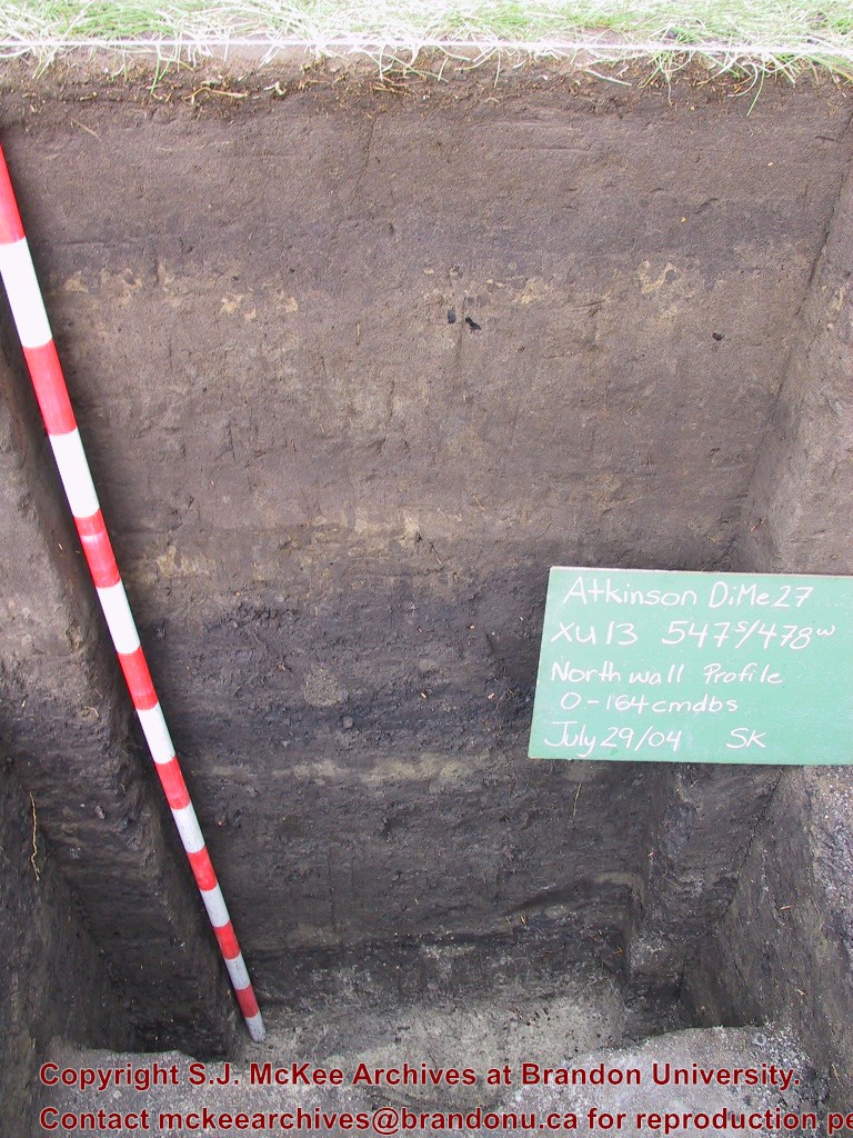
The Atkinson site is one of the oldest excavated sites in Manitoba and has been Radiocarbon dated to 6,500 years before present. The Atkinson site is located on the bank of the Souris River and was discovered when a hearth (fire pit) was seen eroding out of the bank. Based on the date of the site and the kind of lithics (stone tools) present it is considered a Gowen occupation. The Atkinson site is evidence that bison hunters were active on the northern plains at a very early date. Similar sites have also been found on the High Plains in the U.S. and are referred to as the Mummy Cave Complex. The Atkinson Site is of great importance as it is the first undisturbed site of this type to be excavated in Manitoba and extends the range of these sites south and east from the type-sites in central Saskatchewan. Flintstone Hill The geomorphology of the glacial Lake Hind Basin over the past 11,000 years is known primarily through the study of a cut bank along the Souris River. Flint Stone Hill contains the most complete stratigraphic record for the post-glacial period on the northern plains. The site has been extensively studied by geoarchaeologists, geologists and paleoenvironmentalists over many years and their findings have contributed to our understanding of the region. The North Lauder locale Borden designations of Atkinson site DiMe-27 and Flintstone Hill site DiMe-26. Borden System Archaeological sites in Canada are identified by the Borden system, which is a uniform site designation system. The country is divided into grids based on latitude and longitude in blocks of 10 x 20 minutes. The first 4 letters indicate the block and the following numbers indicate the actual site. For example the area of the Lauder Sandhills in southwestern Manitoba is identified by the letters DM and the North Lauder locale within that area is DiMe. The Atkinson site is DiMe-27 and the Flintstone Hill site DiMe-26. As new sites are discovered they will be numbered sequentially.
Scope and Content
The Series has been divided into two sub-series, including (1) Atkinson site DiMe-27 and Flintstone Hill site DiMe-26.
Name Access
North Lauder locale
Subject Access
Archaeology Atkinson site DiMe-27
Arrangement
Series is arranged by site and by year of field work.
Show Less

Assiniboine River Bridge North of Kemnay

http://archives.brandonu.ca/en/permalink/descriptions9920
Part Of
RG 11 Lawrence Stuckey fonds
Description Level
Item
GMD
graphic
Date Range
[ca. 1938]
Accession Number
1-2002
Part Of
RG 11 Lawrence Stuckey fonds
Creator
George H. Harris
Description Level
Item
Series Number
3.1
Item Number
1-2002.3.1OB5(1)
Accession Number
1-2002
GMD
graphic
Date Range
[ca. 1938]
Physical Description
2 1/2" x 2 1/2"
Material Details
Negative
History / Biographical
This bridge was condemned in the late 1930s but cyclists continued to use it until it was torn down (approximately 1940)
Until the early 1920s the Canadian Pacific Railway maintained a well and pumping station near the southeast corner of this bridge, which pumped water through a pipeline to a locomotive watering tank at Kemnay.
Custodial History
For custodial history see the collection level description of the Lawrence Stuckey collection.
Scope and Content
Assiniboine River Bridge North of Kemnay
Notes
[Mr. Stuckey put a negative and print in the same envelope. We have separated them, numbering the negative OB5(1) and the print OB5(1a).]
Name Access
Assiniboine River Bridge North of Kemnay
Subject Access
manmade geographic features
bridges
Brandon Area Bridges
Repro Restriction
The McKee Archives is the copyright holder for the Stuckey materials.
Storage Location
Lawrence Stuckey collection
Images
Show Less

Assiniboine River Bridge North of Kemnay

http://archives.brandonu.ca/en/permalink/descriptions9921
Part Of
RG 11 Lawrence Stuckey fonds
Description Level
Item
GMD
graphic
Date Range
[ca. 1938]
Accession Number
1-2002
Part Of
RG 11 Lawrence Stuckey fonds
Creator
George H. Harris
Description Level
Item
Series Number
3.1
Item Number
1-2002.3.1OB5(1a)
Accession Number
1-2002
GMD
graphic
Date Range
[ca. 1938]
Physical Description
2 1/2" x 2 1/2"
Material Details
Photograph
History / Biographical
This bridge was condemned in the late 1930s but cyclists continued to use it until it was torn down (approximately 1940)
Until the early 1920s the Canadian Pacific Railway maintained a well and pumping station near the southeast corner of this bridge, which pumped water through a pipeline to a locomotive watering tank at Kemnay.
Custodial History
For custodial history see the collection level description of the Lawrence Stuckey collection.
Scope and Content
Assiniboine River Bridge North of Kemnay
Notes
[Mr. Stuckey put a negative and print in the same envelope. We have separated them, numbering the negative OB5(1) and the print OB5(1a).]
Name Access
Assiniboine River Bridge North of Kemnay
Subject Access
manmade geographic features
bridges
Brandon Area Bridges
Repro Restriction
The McKee Archives is the copyright holder for the Stuckey materials.
Storage Location
Lawrence Stuckey collection
Images
Show Less

Atkinson II site 2004 - profile of the north wall of XU 13

http://archives.brandonu.ca/en/permalink/descriptions12253
Part Of
RG 7 Beverley Nicholson fonds
Description Level
Item
GMD
graphic
Date Range
2004
Accession Number
1-2010
Part Of
RG 7 Beverley Nicholson fonds
Description Level
Item
Series Number
2.1.3.5
Item Number
2.1.3.5.13
Accession Number
1-2010
GMD
graphic
Date Range
2004
Physical Description
768 x 1024 (607)
Material Details
JPEG
History / Biographical
Photograph taken during 2004 Brandon University Archaeology excavations at Atkinson II site.
Scope and Content
Profile of the north wall of excavation unit 13 at the Atkinson II site 2004.
Name Access
Atkinson II site 2004 - profile of the north wall of XU 13
Subject Access
Archaeology North lauder locale Atkinson site DiMe-27 Atkinson II site 2004 photographs
Images
Show Less

Atkinson site 2003 - site record north wall XU 1

http://archives.brandonu.ca/en/permalink/descriptions12169
Part Of
RG 7 Beverley Nicholson fonds
Description Level
File
Accession Number
1-2010
Part Of
RG 7 Beverley Nicholson fonds
Description Level
File
Series Number
2.1.1.3
File Number
5
Accession Number
1-2010
Physical Description
one page
Material Details
PDF
History / Biographical
Record of excavation unit 1 north wall profile at the Atkinson site 2003.
Scope and Content
Site excavation records of excavation units may include: level summaries, floor plans, feature sheets, wall profiles, unit summaries and any other additional information relating to the unit.
Name Access
Atkinson site 2003 - site record north wall XU 1
Subject Access
Archaeology North Lauder locale
Atkinson site DiMe-29 Atkinson site 2003
Documents

2.1.1.3.5__N_Wall_XU1.pdf

Read PDF Download PDF
Show Less

20 records – page 1 of 1.