Photograph shows a large group of men dressed in shirts and ties with jackets or cardigans posing on a lawn. One man has a pansy on his lapel. Before them are lawn bowling balls in netted bags and a large dog.
Notes
Writing on the front of the photograph reads: 20th Annual tournament Manitoba Lawn Bowling Association Wpg. Aug. 8-13-27, Bauslaugh Studio
In 1901, American entrepreneur Francis Hector Clergue (1856-1939) obtained the charter for the Ontario, Hudson Bay and Western Railway. Following his purchase, he reincoporated the Algoma Central Railway to the Algoma Central and Hudson's Bay Railway. (Source: Sault St. Mairie Public Library, "Transportation - Algoma Central Railway," Sault History Online, 2008)
Scope and Content
Photograph shows railroad tracks cutting through the Canadian Shield.
Notes
Writing beneath the photograph in the album reads: Algoma Central & Hundson Bay Ry.
The Lake Talbot tresle was a point along the Algoma Central Railway line that connected the Helen Mine to the Michipicoten Harbour. It is located north of Wawa and southwest of the Helen Mine.
Scope and Content
Photograph shows several men walking a railway line. Before them is a tresle bridge.
Notes
Writing beneath the photograph in the album reads: Lake Talbott Tresle [sic.]
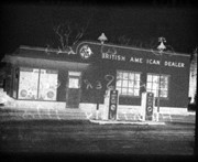
Brient was a point along the Algoma Central Railway line that connected the Helen Mine to the Michipicoten Harbour. It is located southwest of Wawa, Ontario.
Scope and Content
Photograph shows several men standing on railway tracks before a wood-framed train station in the winter. A sign attached to the station reads: British American Express Co. The man in the foreground appears to have a mailbag over on his back and several newspapers tucked beneath his arm.
Notes
Writing beneath the photograph in the album reads: station at Brient
Trembley was a point along the Algoma Central Railway line that connected the Helen Mine to the Michipicoten Harbour. It is located southwest of Wawa, Ontario.
Scope and Content
Photograph shows railroad tracks. A line of ore cars stretch along one track. Writing on the side of one of the cars (#3017) reads: Algoma Central Railway Co.
Notes
Writing beneath the photograph in the album reads: Trembley - Ore Cars
Brient was a point along the Algoma Central Railway line that connected the Helen Mine to the Michipicoten Harbour. It is located southwest of Wawa, Ontario.
Scope and Content
Photograph shows ore box cars in a railway yard.
Notes
Writing beneath the photograph in the album reads: yard at Brient
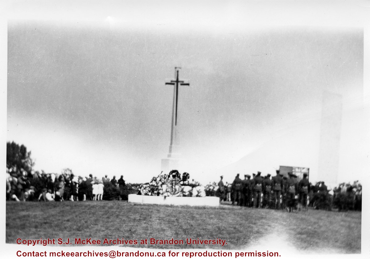
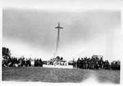
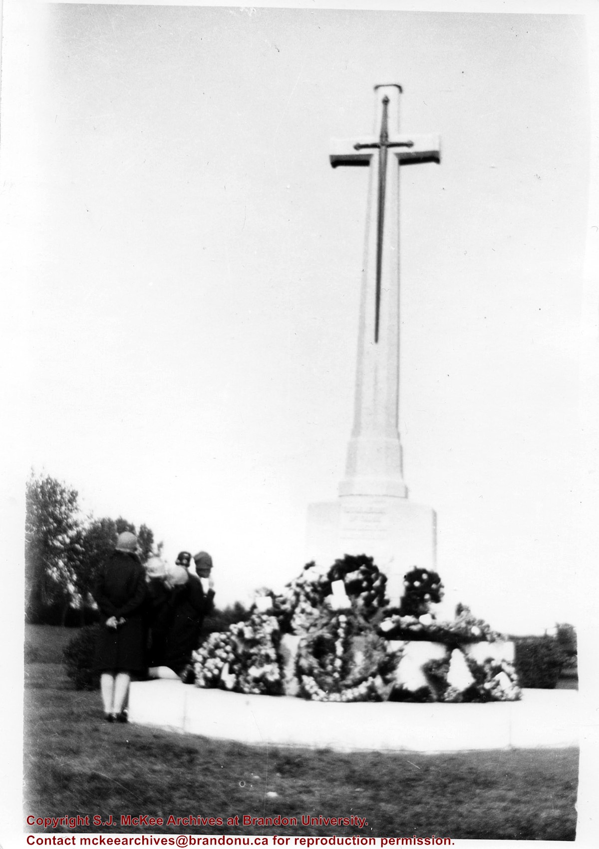
According to Veterans' Affairs Canada, there are 25 Crosses of Sacrifice in North America. The crosses were designed by the Canadian War Graves Commission's (CWGC) architect Sir Reginald Bloomfield, who designed a stone cross affixed with a bronze symbolic sword. The CWGC granted the Brandon Municipal Cemetery permission to privately erect the Cross of Sacrifice in its cemetery in exchange for maintaining the war graves in its cemetery.
The Brandon Great War Veterans Association erected the Cross of Sacrifice in the Brandon Municipal Cemetery in 1924 after a 10-day public fundraising campaign. At the time the Brandon Daily Sun reported that the Veterans Association required $5,000 to pay for the cross and the campaign ultimately raised $7,500. The memorial was initially dedicated to the local citizens who died as a result of the First World War.
Custodial History
Donated to Fred McGuinness by G. Baldock in 1971
Scope and Content
Photograph is of a memorial service at the Cross of Sacrifice in the Brandon Municipal Cemetery. Members of the public are standing to the north of the cross, while soldiers and veterans stand to the south. A number of wreaths have been placed at the base of the monument.
Notes
Writing on the back of the photograph reads: 5 prints. Dedication of the war memorial. around 1926-1927-28. I was scout master under Comissioner Harry Booth. P.E.H.
According to Veterans' Affairs Canada, there are 25 Crosses of Sacrifice in North America. The crosses were designed by the Canadian War Graves Commission's (CWGC) architect Sir Reginald Bloomfield, who designed a stone cross affixed with a bronze symbolic sword. The CWGC granted the Brandon Municipal Cemetery permission to privately erect the Cross of Sacrifice in its cemetery in exchange for maintaining the war graves in its cemetery.
The Brandon Great War Veterans Association erected the Cross of Sacrifice in the Brandon Municipal Cemetery in 1924 after a 10-day public fundraising campaign. At the time the Brandon Daily Sun reported that the Veterans Association required $5,000 to pay for the cross and the campaign ultimately raised $7,500. The memorial was initially dedicated to the local citizens who died as a result of the First World War.
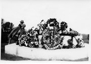
Private Frank Barker (#33281) died on 27 June 1918. A member of the Canadian Army Medical Corps, Pte. Barker was on the Llandovery Castle Hospital Ship when it was torpedoed.
Custodial History
Donated to Fred McGuinness by G. Baldock in 1971
Scope and Content
Photograph is of a close-up of a number of wreaths laid at the base of the Cross of Sacrifice in the Brandon Municipal Cemetery during a memorial service.
Notes
Writing on the back of the photograph reads: Winnifred Barker places wreath in memory of Frank Barker (my uncle) 1st Field Ambulance, many decorations including the "Mons Star," lost on the Hospital Ship Landovery Castle, 1918. - G. Baldock 1971 -
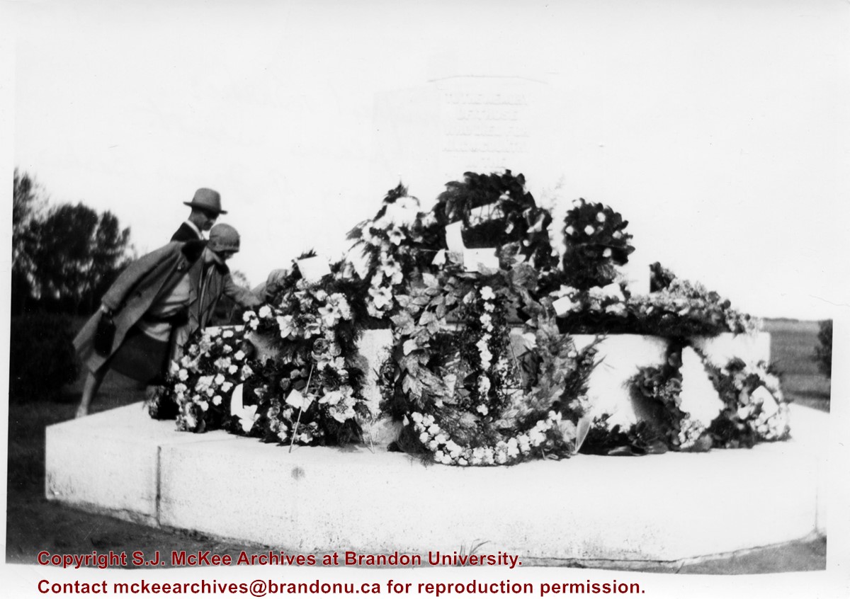
According to Veterans' Affairs Canada, there are 25 Crosses of Sacrifice in North America. The crosses were designed by the Canadian War Graves Commission's (CWGC) architect Sir Reginald Bloomfield, who designed a stone cross affixed with a bronze symbolic sword. The CWGC granted the Brandon Municipal Cemetery permission to privately erect the Cross of Sacrifice in its cemetery in exchange for maintaining the war graves in its cemetery.
The Brandon Great War Veterans Association erected the Cross of Sacrifice in the Brandon Municipal Cemetery in 1924 after a 10-day public fundraising campaign. At the time the Brandon Daily Sun reported that the Veterans Association required $5,000 to pay for the cross and the campaign ultimately raised $7,500. The memorial was initially dedicated to the local citizens who died as a result of the First World War.
Custodial History
Donated to Fred McGuinness by G. Baldock in 1971
Scope and Content
Photograph is of a group of people examining wreaths that have been laid at the base of the Cross of Sacrifice in the Brandon Municipal Cemetery during a memorial service.
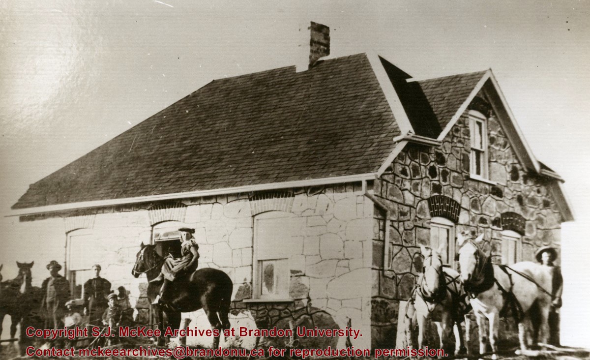
Mrs. Hilda Rosa Osmond (nee Bridgeman) was born in Hampshire, England in 1888 to parents Edwin Samuel Bridgeman (b.16 Jul 1852; d. 19 June 1922, Brandon) and Rosa Holkham (b. 26 Mar 1859; d. 27 May 1927, Brandon). Edwin was a sailor and Rosa was a dressmaker.
Following the death of her brother Edwin Frederick Bridgeman (1886-1890), the family immigrated to Canada in 1891. The Bridgeman's took the train to Griswold, Manitoba, and settled near Edwin's brother, Albert Bridgeman, and together they farmed the N 1/2 of 36-12-23. The Bridgeman's had three more children, Ellen Grace (b. 27 Jan 1893; d. 22 Feb 1893), Harry Volantine/Valentine (b. 14 Feb 1894), and Charlie Cuthbert (b. 03 Aug 1896; d. 25 Aug 1901). Mr. and Mrs. Edwin Bridgeman retired in 1913 and moved to Brandon where they lived until their respective deaths. The couple are interred in the Brandon Municipal Cemetery.
Hilda married William Arthur Osmond (b. 1867; d. 26 Oct 1943) of Baisingstoke, England, on 31 Jan 1913. They had a daughter Nellie who later married Glen Mossey. The family continued to farm the property on section 36.
Hilda Rosa Osmond passed away in 1980 at the age of 91. She is interred in the Greenwood Cemetery near Harding, Manitoba, where her husband and siblings also rest.
(Sources: England, Births and Christenings, 1538-1975. Salt Lake City, Utah: FamilySearch, 2013 [online]; Findagrave.com; Harding History Committee, Home to Harding 1879-1981 (Brandon: Leech Printing, 1981); Manitoba Vital Statistics Database)
Custodial History
Photograph given to Fred McGuinness by Burton Strange of Kenton, 25 Nov 1974
Scope and Content
Photograph shows a field stone house builty in 1901 by Edwin and Rosa Bridgeman near Harding, Manitoba. Edwin and Rosa Bridgeman are pictured on the right with Harry and Charlie, shortly before Charlie's death. Hilda sits atop the horse. Albert Bridgeman is pictured on the right with a horse team.
Notes
Photograph was published in the community history by Harding History Committee, Home to Harding 1879-1981 (Brandon: Leech Printing, 1981), 50
The International Peace Garden is situated on the international border between Manitoba and North Dakota, adjacent to the Canadian Border Services Boissevain port of entry and the U.S. Customs and Border Protection Agency's Dunseith port of entry. The dedication for the International Peace Garden was held on July 14, 1932. It was estimated that 50,000 people were in attendance on opening day. The park is 9.5-square kilometers or 3.54-square miles.
Custodial History
Pictures were sent to Fred McGuinness in 1970 from E.M. Bergson of Brandon.
Scope and Content
Photograph shows large crowds surrounding a stone cairn draped in American and Union Jack flags. According to the International Peace Garden website, the pictured cairn was built from stones gathered from Manitoba and North Dakota. The crowds gathered for the 1932 dedication of the International Peace Garden.
Notes
The back of the photograph is stamped: Enameloid Velox Print by the Jul 27 1932, Chicago Postal Photo Supplies, Regina, Sask.
These records appear to have been produced between 1986 and 1987, the researching and writing period for another monograph, Manitoba: The Province & The People. Published in 1988 by Windsor Publications (Burlington, Ontario), The Keystone Province: An Illustrated History of Manitoba Enterprise is a 184-page hard cover book, containing 250 black-and-white illustrations and 40 colour photographs.
The authors cover 378 years of Manitoba entrepreneurial history, starting with the Aboriginal Peoples and the early fur trade, ensuing Red River settlement, followed by the war years, and emerging Manitoba economies. The final chapter of the book contains select profiles of Manitoba businesses, many of which were acknowledged as financial contributors to the project.
BU faculty members Dr. Kenneth “Ken” Stephen Coates, Assistant Professor of History, and Mr. Fred McGuinness, Lecturer in Journalism, authored the book. Dr. Coates accepted a position as an assistant professor of Canadian History at the University of Victoria during the book’s production. BU Professor of History, Dr. William R. Morrison, was credited as the picture researcher for the publication. Free-lance writer Roger Newman was responsible for preparing the Manitoba business biographies in the final chapter. The book was produced in co-operation with the Manitoba Chamber of Commerce.
Custodial History
Records were collected and created by McGuinness and Coates during the creation of the monographs Manitoba: The Province & The People and The Keystone Province: An Illustrated History of Manitoba Enterprise. The materials were donated to the SJ McKee Archives by the Estate of Fred McGuinness circa 2011. The Archives accessioned the records in 2015.
Scope and Content
The subseries consist of textual records, created and collected during the production of the monographs Manitoba: The Province & The People and The Keystone Province: An Illustrated History of Manitoba Enterprise. It includes journal articles, book chapters, Government of Manitoba industry publications, a few original photographs used in the publication, and drafts for chapter “brites.”
Notes
Information in the history/biography was taken from the The Keystone Province: An Illustrated History of Manitoba Enterprise dust jacket and patrons section of the book
In the file level inventory, square brackets at end of file names reference the original location of the file in the unprocessed Fred McGuinness collection. The original location is also noted on the front of each file folder
Accruals
Closed
Language Note
Fred McGuinness often uses journalistic jargon to label his files. A
“brite” refers to a short, amusing story. McGuinness often
organized his ideas and research materials by potential brite topic
Finding Aid
A file level inventory is available
Storage Location
2015 accessions
Arrangement
Arrangement was artificially created by the Archives. Files in this subseries have been arranged according to the order in which brites first appear in the book
Documents
McG 5_5 Keystone Province MB Enterprise inventory.pdf
Manitoba Flying Farmers Convention appears to have been a convention for farmers who planted and sprayed their crops using aerial techniques. The Manitoba Flying Farmers were organized in 1956 in Brandon, Manitoba. Organizational meetings were held in a hanger at the Brandon Flying Club. The first Regional 5 Flying Farmers Convention in Manitoba was held 1961. Nearly 200 people attended the first convention from various provinces and states including: Alberta, Saskatchewan, North Dakota, South Dakota, Minnisota, Wisconsin, Montana and Colorado. Alberta and Saskatchewan had their own district leaving Manitoba in a district with North Dakota, South Dakota, Minnisota and Wisconsin. This photo was taken at the 11th Annual Manitoba Flying Farmers Convention on the weekend of April 7th, 1967.
Custodial History
See Fonds level description for custodial history
Scope and Content
Image of a woman presenting at the podium from the front table. Two men are sitting on either side of the woman. A sign saying "Manitoba Flying Farmers" is at the base of the table. The image appears to have been taken at the Prince Edward Hotel.
Notes
Hisotry/Bio information taken from Brandon Sun. Description by Jillian Combs.
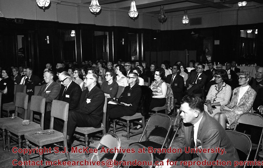
Manitoba Flying Farmers Convention appears to have been a convention for farmers who planted and sprayed their crops using aerial techniques. The Manitoba Flying Farmers were organized in 1956 in Brandon, Manitoba. Organizational meetings were held in a hanger at the Brandon Flying Club. The first Regional 5 Flying Farmers Convention in Manitoba was held 1961. Nearly 200 people attended the first convention from various provinces and states including: Alberta, Saskatchewan, North Dakota, South Dakota, Minnisota, Wisconsin, Montana and Colorado. Alberta and Saskatchewan had their own district leaving Manitoba in a district with North Dakota, South Dakota, Minnisota and Wisconsin. This photo was taken at the 11th Annual Manitoba Flying Farmers Convention on the weekend of April 7th, 1967.
Custodial History
See Fonds level description for custodial history
Scope and Content
Image of the attendants of the convention who are listening to the speaker. The image appears to have been taken in the Prince Edward Hotel.
Notes
Hisotry/Bio information taken from Henderson's Directories. Description by Jillian Combs.


)