Skip header and navigation

Revise Search

20 records – page 1 of 1.

Aerial view: Brandon College

http://archives.brandonu.ca/en/permalink/descriptions594
Part Of
Brandon University Photograph collection
Description Level
Item
GMD
graphic
Date Range
[fall 1964?]
Part Of
Brandon University Photograph collection
Description Level
Item
Series Number
2.1
Item Number
BUPC 2.1.2
GMD
graphic
Date Range
[fall 1964?]
Physical Description
5" x 4" (b/w)
Scope and Content
Brandon College looking south from 19th Street. Photograph was taken after Flora Cowan Hall was built but before construction of the Education Building.
Subject Access
aerial photographs
campus photographs
campus buildings
Brandon streets
Images
Show Less

Aerial view: Brandon College from 23rd Street

http://archives.brandonu.ca/en/permalink/descriptions602
Part Of
Brandon University Photograph collection
Description Level
Item
GMD
graphic
Date Range
[1963-1966]
Part Of
Brandon University Photograph collection
Description Level
Item
Series Number
2.1
Item Number
BUPC 2.1.9
GMD
graphic
Date Range
[1963-1966]
Physical Description
5" x 4" (b/w)
Scope and Content
Image is looking east northeast from approximately the 300 block of 23rd Street between Lorne and Louise Avenues. Photograph shows the Brandon College campus after the opening of the original Music Building in 1963, but before the construction of the Education Building in 1966. A number of house on the 300 blocks of 22nd and 21st Streets are visible in the foreground, with the A.E. McKenzie Seed Co., the Prince Edward Hotel and various grain elevators on the horizon.
Subject Access
aerial photographs
campus photographs
campus buildings
Brandon streets
Grain elevators
Images
Show Less

Aerial view - Brandon College looking southwest

http://archives.brandonu.ca/en/permalink/descriptions601
Part Of
Brandon University Photograph collection
Description Level
Item
GMD
graphic
Date Range
[1963-1966]
Part Of
Brandon University Photograph collection
Description Level
Item
Series Number
2.1
Item Number
BUPC 2.1.8
GMD
graphic
Date Range
[1963-1966]
Physical Description
5" x 4" (b/w)
Scope and Content
Image shows the Brandon College campus from 17th Street looking southwest. The photo was taken after the completion of the original Music Building in 1963, but construction of the Education Building. Also visible are a number of properties on the 200 block of 18th Street and the 200 block of 20th Street.
Subject Access
aerial photographs
campus photographs
campus buildings
Brandon streets
Images
Show Less

Aerial view - Brandon University campus

http://archives.brandonu.ca/en/permalink/descriptions7989
Part Of
Brandon University Photograph collection
Description Level
Item
GMD
graphic
Date Range
c. 2000
Part Of
Brandon University Photograph collection
Creator
Photograph commissioned by Brandon University and taken by Yourview Aerial Scenics Ltd.
Description Level
Item
Series Number
2.1
Item Number
BUPC 2.1.55
GMD
graphic
Date Range
c. 2000
Physical Description
6" x 4" (colour)
Scope and Content
View is southwest from approximatley 16th Street between Princess and Rosser Avenues. Photograph shows the Brandon University campus, as well as surrounding residential blocks, including Flemming, J.R. Reid and Vincent Massey schools.
Subject Access
aerial photographs
campus photographs
campus buildings
Brandon streets
Images
Show Less

Aerial view - Brandon University campus

http://archives.brandonu.ca/en/permalink/descriptions7990
Part Of
Brandon University Photograph collection
Description Level
Item
GMD
graphic
Date Range
c. 2000
Part Of
Brandon University Photograph collection
Creator
Photograph commissioned by Brandon University and taken by Yourview Aerial Scenics Ltd.
Description Level
Item
Series Number
2.1
Item Number
BUPC 2.1.56
GMD
graphic
Date Range
c. 2000
Physical Description
6" x 4" (colour)
Scope and Content
View is west southwest from approximatley 16th Street between Princess and Lorne Avenues. Photograph shows the Brandon University campus, as well as surrounding residential blocks between 16th and 23rd Streets, Princess and Louise Avenues..
Subject Access
aerial photographs
campus photographs
campus buildings
Brandon streets
Images
Show Less

Aerial view - Brandon University campus

http://archives.brandonu.ca/en/permalink/descriptions7991
Part Of
Brandon University Photograph collection
Description Level
Item
GMD
graphic
Date Range
c. 2000
Part Of
Brandon University Photograph collection
Creator
Photograph commissioned by Brandon University and taken by Yourview Aerial Scenics Ltd.
Description Level
Item
Series Number
2.1
Item Number
BUPC 2.1.57
GMD
graphic
Date Range
c. 2000
Physical Description
6" x 4" (colour)
Scope and Content
View is west from approximatley 17th Street between Lorne and Louise Avenues. Photograph shows a portion of the Brandon University campus (excluding the Education Building and anything north of it), as well as surrounding residential blocks from approximatley 17th Street to 22nd Street.
Subject Access
aerial photographs
campus photographs
campus buildings
Brandon streets
Images
Show Less

Aerial view - Brandon University campus

http://archives.brandonu.ca/en/permalink/descriptions7992
Part Of
Brandon University Photograph collection
Description Level
Item
GMD
graphic
Date Range
c. 1990
Part Of
Brandon University Photograph collection
Description Level
Item
Series Number
2.1
Item Number
BUPC 2.1.58
GMD
graphic
Date Range
c. 1990
Physical Description
5" x 3.5" (colour)
Scope and Content
View is west northwest from approximatley 16th Street and Louise Avenue. Photograph shows the Brandon University campus, prior to the Library Extension, and a large portion of the city to the west of the campus.
Subject Access
aerial photographs
campus photographs
campus buildings
Brandon streets
Images
Show Less

Aerial view - Brandon University campus

http://archives.brandonu.ca/en/permalink/descriptions7993
Part Of
Brandon University Photograph collection
Description Level
Item
GMD
graphic
Date Range
c. 1990
Part Of
Brandon University Photograph collection
Description Level
Item
Series Number
2.1
Item Number
BUPC 2.1.59
GMD
graphic
Date Range
c. 1990
Physical Description
5" x 3.5" (colour)
Scope and Content
View is northwest from approximatley 16th Street and Louise Avenue. Photograph shows the Brandon University campus, prior to the Library Extension, and a large portion of the city to the west of the campus.
Subject Access
aerial photographs
campus photographs
campus buildings
Brandon streets
Show Less

Brandon University campus construction

http://archives.brandonu.ca/en/permalink/descriptions8005
Part Of
Brandon University Photograph collection
Description Level
Item
GMD
graphic
Date Range
c. 1996
Part Of
Brandon University Photograph collection
Creator
Photographer: Sandy Black
Description Level
Item
Series Number
2.1
Item Number
BUPC 2.1.71
GMD
graphic
Date Range
c. 1996
Physical Description
4" x 6" (colour)
Scope and Content
View is northeast probably from the roof of McMaster Hall. Photograph shows the construction of the new roof on Clark Hall and the Brandon College Building. A portion of the east side of the 000 and 100 blocks of 18th Street, as well as the corner of 18th Street and Rosser Avenue are visible in the upper left hand corner. This includes the "Downtown Brandon" sign.
Subject Access
campus photographs
campus buildings
campus construction
Brandon streets
Images
Show Less

Brandon University campus construction

http://archives.brandonu.ca/en/permalink/descriptions8006
Part Of
Brandon University Photograph collection
Description Level
Item
GMD
graphic
Date Range
c. 1996
Part Of
Brandon University Photograph collection
Creator
Photographer: Sandy Black
Description Level
Item
Series Number
2.1
Item Number
BUPC 2.1.72
GMD
graphic
Date Range
c. 1996
Physical Description
6" x 4" (colour)
Scope and Content
View is north northeast probably from the roof of McMaster Hall. Photograph shows the construction of the new roof on Clark Hall and the Brandon College Building, as well as the construction of the extension to Clark Hall and the skywalk. Portions of the city as far north as the Assiniboine River are also visible.
Subject Access
campus photographs
campus buildings
campus construction
Brandon streets
Images
Show Less

Brandon University campus construction

http://archives.brandonu.ca/en/permalink/descriptions8016
Part Of
Brandon University Photograph collection
Description Level
Item
GMD
graphic
Date Range
c. 1996
Part Of
Brandon University Photograph collection
Creator
Photographer: Sandy Black
Description Level
Item
Series Number
2.1
Item Number
BUPC 2.1.82
GMD
graphic
Date Range
c. 1996
Physical Description
4" x 6" (colour)
Scope and Content
View is northeast from the Brandon College Building. Photograph shows the inside of the Brandon College Building after it had been gutted and then partially rebuilt. The exterior fascade of the west side of the building can be clearly seen in this photograph. A number of houses on the east side of 200 block of 18th Street are also visible, as is the stone fence on Princess Avenue and the flag pole on the front lawn.
Subject Access
campus photographs
campus construction
Brandon streets
Images
Show Less

Brandon University campus construction

http://archives.brandonu.ca/en/permalink/descriptions8018
Part Of
Brandon University Photograph collection
Description Level
Item
GMD
graphic
Date Range
c. 1996
Part Of
Brandon University Photograph collection
Description Level
Item
Series Number
2.1
Item Number
BUPC 2.1.84
GMD
graphic
Date Range
c. 1996
Physical Description
6" x 4" (colour)
Scope and Content
View is north northeast from the roof of McMaster Hall. Photograph shows the campus under construction during the renovation of the Brandon College Building and Clark Hall. The photograph was taken in late fall after the roof had been removed from the buildings but before the construction of the extension of Clark Hall. Construction materials litter the courtyard and driveway. The view looking north extends to The North Hill - a number of residential blocks, particularly to the northeast of 18th Street are visible. Buildings include the International Harvester Building and Kin Village.
Subject Access
campus photographs
campus buildings
campus construction
Brandon streets
Images
Show Less

Brandon University campus construction

http://archives.brandonu.ca/en/permalink/descriptions8020
Part Of
Brandon University Photograph collection
Description Level
Item
GMD
graphic
Date Range
c. 1996
Part Of
Brandon University Photograph collection
Creator
Photographer: Sandy Black
Description Level
Item
Series Number
2.1
Item Number
BUPC 2.1.86
GMD
graphic
Date Range
c. 1996
Physical Description
6" x 4" (colour)
Scope and Content
View is north northeast probably from the roof of McMaster Hall. Photograph shows the construction of the new roof on Clark Hall and the Brandon College Building, as well as the construction of the extension to Clark Hall and the skywalk. The view looking north extends to The North Hill - a number of residential blocks, particularly to the northeast of 18th Street are visible. Buildings include the International Harvester Building and Kin Village.
Subject Access
campus photographs
campus buildings
campus construction
Brandon streets
Images
Show Less

Counsellors of the Municipality of Elton

http://archives.brandonu.ca/en/permalink/descriptions10200
Part Of
RG 12 Brandon and Area Photograph Collection
Description Level
Item
GMD
graphic
Date Range
1912
Accession Number
5-2007
Part Of
RG 12 Brandon and Area Photograph Collection
Description Level
Item
Series Number
5
Item Number
BAPC 5.6
Accession Number
5-2007
GMD
graphic
Date Range
1912
Physical Description
7.5" x 9.5" (b/w)
Material Details
On matting
Physical Condition
Two small tears along the edge and one scratch in upper right corner. Matting is stained and discoloured.
Custodial History
The records in the Norma Laird collection passed from Irene Clarke to her daughter Norma, who donated them to the McKee Archives on January 15, 2007.
Scope and Content
Portrait of the cousellors of the Municipality of Elton.
Notes
This photograph was originally part of the Norma Laird collection.
Name Access
Alex Robertson
Charlie McDougal
W. Davidson
J.A. Allan
R.J. Black
Jim Rourke
W.J. Cundy
Rob Reid
Municipality of Elton
Subject Access
political figures
elected officials
portraits
Storage Location
BAPC oversize storage drawer
Related Material
Norma Laird collection (5-2007)
Images
Show Less

County Council of the County of Brandon

http://archives.brandonu.ca/en/permalink/descriptions10202
Part Of
RG 12 Brandon and Area Photograph Collection
Description Level
Item
GMD
graphic
Date Range
1882
Accession Number
1-2000
Part Of
RG 12 Brandon and Area Photograph Collection
Creator
Photographer: Jerrett's
Description Level
Item
Series Number
5
Item Number
BAPC 5.9
Accession Number
1-2000
GMD
graphic
Date Range
1882
Physical Description
4.5" x 6.5" (b/w)
Material Details
On matting
Custodial History
Donated to the McKee Archives by the Souris Museum in 2000.
Scope and Content
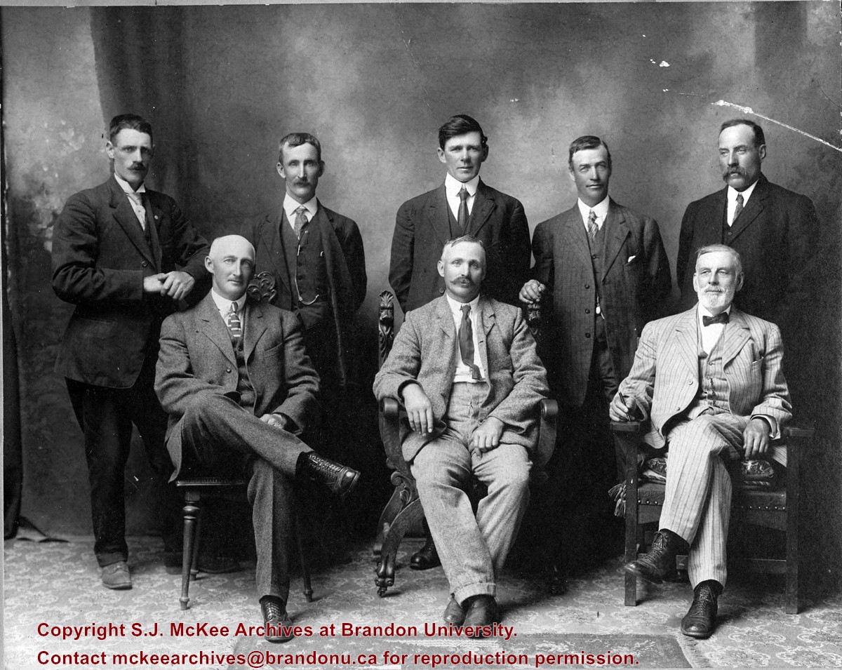
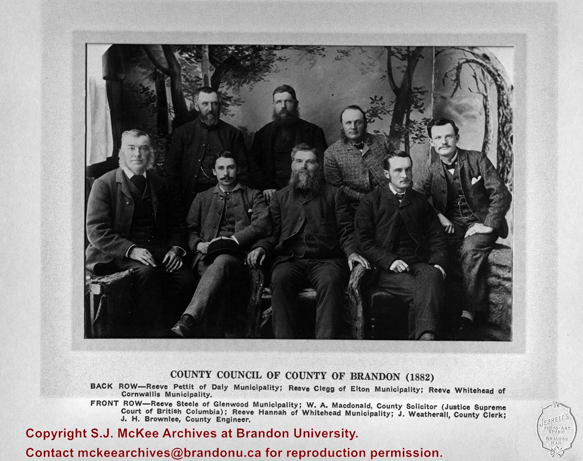
Portrait of the County Council of the County of Brandon. Back Row: Reeve Pettit of Daly Municipality, Reeve Clegg of Elton Municipality, Reeve Whitehead of Cornwallis Municipality. Front Row: Reeve Steele of Glenwood Municipality, W.A. MacDonald, County Solicitor (Justice Supreme Court of British Columbia); Reeve Hannah of Whitehead Municipality, J. Weatherall, County Clerk, J.H. Brownlee, County Engineer
Name Access
W.A. MacDonald
J. Weatherall
J.H. Brownlee
Daly Municipality
Elton Municipality
Cornwallis Municipality
Glenwood Municipality
Whitehead Municipality
Subject Access
political figures
elected officials
portraits
Storage Location
BAPC photograph drawer
Images
Show Less
Part Of
RG 12 Brandon and Area Photograph Collection
Description Level
Item
GMD
graphic
Date Range
c. 1960
Part Of
RG 12 Brandon and Area Photograph Collection
Description Level
Item
Series Number
2
Item Number
BAPC 2.40
GMD
graphic
Date Range
c. 1960
Physical Description
8" x 10" (b/w)
Material Details
On matting (12" x 10")
History / Biographical
Curran Park is located at 4100 Grand Valley Rd, Brandon, MB. Originally called Suburban Park, it underwent a formal name change in 1934, in honour of J.P. Curran, a lawyer, civil servant and judge, who died in 1928. The City of Brandon first set aside $6000 for the acquisition of a new park in 1911, but the acquisition of appropriate land stalled for a number of years. Finally in 1919, the city was able to acquire a parcel of Crown land the Brandon Industrial School was located on, to establish the park; the land was acquired through a 99-year lease. Suburban Park officialy opened in 1921. The development of the park was gradual. Some of the work was completed as part of the Brandon Parks Board's unemployment relief planning; from 1931-1936, relief workers cleared underbrush, thinned trees, constructed a road and built latrines. In 1933 a refreshment stand was approved and a large cook stove was donated. The City of Brandon and the Department of Agriculture (in right of the Crown) agreed to terminate the original park lease in March 1965, with the city purchasing the land outright. Curran Park was sold to Gretna businessman Gerald Voth in 2001, and renamed Turtle Crossing.
Scope and Content
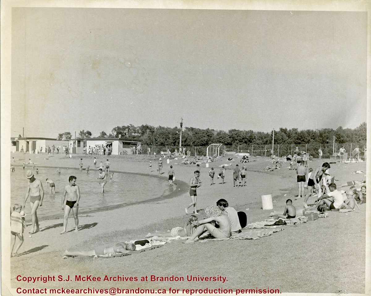
Item is a photograph of the pool at Curran Park, Brandon, MB.
Notes
History/Bio information was taken from A Cup of Cold Water: Alfred Kirkness and the Brandon Residential School Cemeteries by Anne Lindsay, Clare Cook, and David Cuthbert (Manitoba History journal, Number 78, Summer 2015).
Name Access
Curran Park
Subject Access
swimming
recreation facilities
swimming pools
leisure activities
Storage Location
BAPC photograph drawer
Images
Show Less

Edward A. McGill and group of children

http://archives.brandonu.ca/en/permalink/descriptions10191
Part Of
RG 12 Brandon and Area Photograph Collection
Description Level
Item
GMD
graphic
Date Range
[197-]
Part Of
RG 12 Brandon and Area Photograph Collection
Description Level
Item
Series Number
5
Item Number
BAPC 5.1
GMD
graphic
Date Range
[197-]
Physical Description
5" x 7" (b/w)
Scope and Content
Photograph of E.A. McGill, MLA for Brandon Conservative West, at the Manitoba Legislature with a group of children.
Name Access
E.A. McGill
Manitoba Legislature
Progressive Conservative Party
Subject Access
political figures
elected officials
Storage Location
BAPC photograph drawer
Images
Show Less
Part Of
Brandon University Photograph collection
Description Level
Item
GMD
graphic
Date Range
c. 1985
Part Of
Brandon University Photograph collection
Description Level
Item
Series Number
2.1
Item Number
BUPC 2.1.60
GMD
graphic
Date Range
c. 1985
Physical Description
5" x 3.5" (colour)
Scope and Content
Photograph shows the removal of one of the houses formerly located on 20th Street between Louise and Princess Avenues. The houses on those blocks were removed to create parking lots for the University. A Fed Zavislak Ltd. Well Drilling & Trucking pickup truck is visible at the curb.
Subject Access
campus photographs
Brandon streets
Images
Show Less
Part Of
Brandon University Photograph collection
Description Level
Item
GMD
graphic
Date Range
c. 1985
Part Of
Brandon University Photograph collection
Description Level
Item
Series Number
2.1
Item Number
BUPC 2.1.61
GMD
graphic
Date Range
c. 1985
Physical Description
5" x 3.5" (colour)
Scope and Content
Photograph shows the removal of one of the houses formerly located on 20th Street between Louise and Princess Avenues. The houses on those blocks were removed to create parking lots for the University.
Subject Access
campus photographs
Brandon streets
Images
Show Less

J.D. McGregor, Lt. Governor

http://archives.brandonu.ca/en/permalink/descriptions10199
Part Of
RG 12 Brandon and Area Photograph Collection
Description Level
Item
GMD
graphic
Date Range
[between 1930 and 1934]
Accession Number
4-1998
Part Of
RG 12 Brandon and Area Photograph Collection
Creator
Photographer: Foote and James Photographers, Winnipeg
Description Level
Item
Series Number
5
Item Number
BAPC 5.5
Accession Number
4-1998
GMD
graphic
Date Range
[between 1930 and 1934]
Physical Description
10.5" x 13" (b/w)
Scope and Content
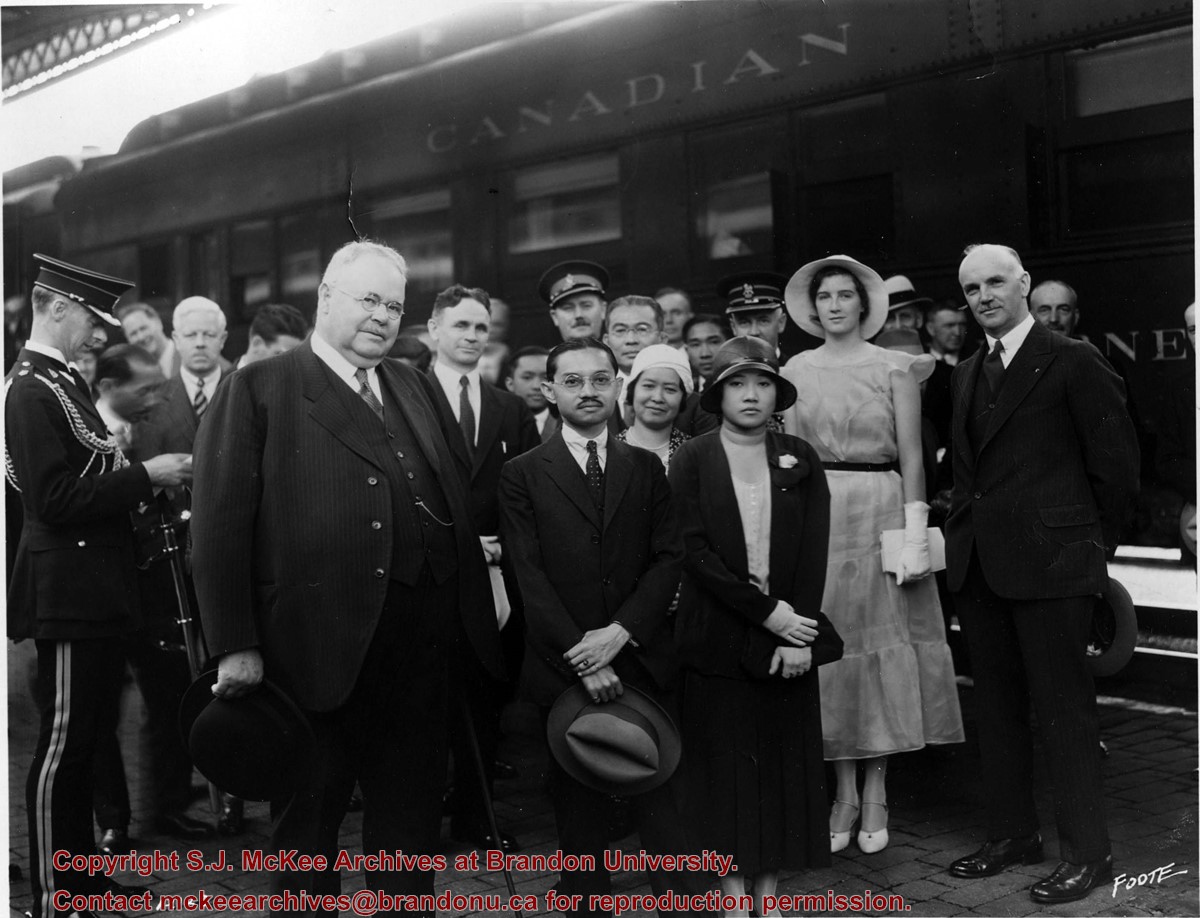
Photograph shows a reception of the King and Queen of Siam at the Winnipeg Railway Station by Manitoba dignitaries. L to R: Major M.Turner, Hon. J.D. McGregor, Premier John Bracken (1922-1943), Their Majesties the King and Queen of Siam, Miss Phyllis Webb, and Mayor Ralph Webb (1925-1927, 1930-1934).
Notes
This photograph was originally part of the J.D. McGregor fonds.
Name Access
Major M. Turner
J.D. McGregor
John Bracken
King of Siam
Queen of Siam
Phyllis Webb
Ralph Webb
Subject Access
political figures
elected officials
railway stations
royal visits
Storage Location
BAPC oversize storage drawer
Related Material
James Duncan McGregor fonds (4-1998)
Images
Show Less

20 records – page 1 of 1.