Field journals have been scanned in multi-page PDF files. Artifact catalogues are PDF files in spreadsheet format. Photographs are in jpeg format
History / Biographical
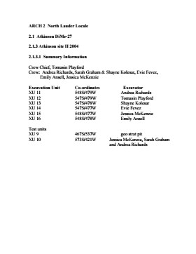
An area east of the Atkinson excavations was also opened for testing in 2004. This area was designated as Atkinson II and a test block was opened and fenced off from the cattle with snow fence. A 4m2 block was surveyed in (units 13 - 16) and two partial units that were truncated by the riverbank (units 11 &12) were also placed to the south of the 4m2 block. Test units 9 and 10 were also excavated.
Field journals have been scanned in multi-page PDF files. Artifact catalogues are PDF files in spreadsheet format. Photographs are in jpeg format.
History / Biographical
After the flooding of the Souris River in 2004 receded, Tomasin Playford and her crew of Andrea Richards, Sarah Graham and Shane Kolesar returned to the Atkinson site and commenced cleaning up the earlier excavation of Atkinson.
An area east of the Atkinson excavations was also opened for testing in 2004. This area was designated as Atkinson II. In some of the field notes it is referred to as Atkinson East. A test block was opened and fenced off from the cattle with snow fence. A 4m2 block was surveyed in (units 13 - 16) and two partial units that were truncated by the riverbank (units 11 &12) were also placed to the south of the 4m2 block.
Three of the students who had completed the recent field school were hired as crew. Jessica McKenzie, Evie Fevez and Emily Ansell joined the crew at the Atkinson II site.
Recoveries from XU 13 - 16:
Large bison bone was recovered from units 11 and 12 and a metal tobacco box seal was recovered from unit 12. More small pieces of metal found in levels 2 and three together with small bone fragments. A bone fragment with butchering marks from a metal tool was recovered from level 6 and pottery was found in level 9. A few lithic flakes were found in level 13 and in a trench at the bottom of unit 13 above a calcite cemented layer. Recoveries from these tests were sparse and diminished as the excavation series became more distant from the river. It is likely that the remains that were recovered represent the northern edge of these occupations.
The upper occupation at Atkinson II appears to be an early historic occupation with a sparse scatter of bone and a few pieces of metal. The lower layers, below level 7 are likely precontact. Units 9 and 10 were dug as test pits and produced very little in the way of cultural materials.
Scope and Content
Sub-sub-sub series contains: Summary information of field methology, number and co-ordinates of excavations, personnel and their staff position; Field journals are daily records of recoveries, features and activities at the site; Site records include excavation level and unit summaries, feature sheets, profiles; sample records and maps; Artifact catalogues are lists and identifications of all artifacts recovered; Photographs are of excavation units, features, the landscape and personnel.
Field journals have been scanned in multi-page PDF files. Artifact catalogues are PDF files in spreadsheet format. Photographs are in jpeg format
History / Biographical
Based on the results of the testing in 2002 and the radiocarbon date of 6,400 years before present, further excavation was warranted at the Atkinson I site. In 2003 Field Chief Holly Alston and crew Shayne Kolesar and Andrea Richards opened a 42m test excavation (units 1 - 4) that included the hearth area.
The unit co-ordinates and excavator are listed on the attached pdf file.
Field journals have been scanned in multi-page PDF files. Artifact catalogues are PDF files in spreadsheet format. Photographs are in jpeg format
History / Biographical
Based on the results of the 2003 excavation, and the radiocarbon date of 6,200 years before present, further excavation was warranted at the Atkinson I site.
In 2004 four units (5, 6, 7, & 8) were surveyed in adjacent to the 2003 units. The unit co-ordinates and excavator are listed on the attached pdf file.
Field journals have been scanned in multi-page PDF files. Artifact catalogues are PDF files in spreadsheet format. Photographs are in jpeg format.
History / Biographical
Based on the results of the testing in 2002 and the radiocarbon date of 6,500 years before present, further excavation was warranted at the Atkinson site. In 2003 Field Chief Holly Alston and crew Shayne Kolesar and Andrea Richards opened a 42m test excavation (units 1 - 4) that included the hearth area.
The site area was covered with a huge sand dune that was slowly sliding into the river as the supporting bank eroded away. As the dune was removed a late woodland camp was found at the dune interface and a large chunk of charcoal dated this occupation to 440+/-60 B.P. cal.1440A.D. This indicated that the dune was a relatively late incursion over the site. This occupation is likely connected to subsequent testing to the east in 2005 that came to be known as Atkinson II.
Methodology:
The crew began shovel shaving the upper strata with the intention of establishing an arbitrary datum when artifacts were encountered or when a level 25cm above the hearth was reached. At 25cm above the hearth an arbitrary surface datum was established and excavation in 5cm levels began. The overbank deposited matrix was a dense, compacted silt clay and it was necessary to soak the excavated materials in buckets and then water screen the material with a high pressure pump over ¼ inch hardware cloth.
Lithic flakes were found at 10cm below datum, above the hearth level. In the next level, large bone, a broken projectile point and additional flakes were found. Increasing amounts of bone and lithic flakes were found as the excavation continued through levels 3 to 5. The top of the hearth was identified at 28cm below datum, below a 2cm layer of well-sorted sand. This sand layer was confined to a small area directly overlying the hearth. It was considered to be a deliberate quenching of the hearth.
After the conclusion of excavating level 6 the hearth was profiled and photographed. The charcoal and ash layer of the hearth was shown to be directly below the sand layer. Levels 6 and 7 revealed a bison bone bed that was consistent with primary and secondary butchering including elements from the vertebral column and appendicular skeleton. Two additional Gowen (Mummy Cave Series) projectile points were also recovered adjacent to the hearth. Level 8 continued to produce larger amounts of bone and many lithic flakes. Level 9 produced a few bone fragments and a small number of lithic flakes. At the conclusion of the excavations, the crew shoveled sand down from the dune to protect the site over winter and through any subsequent spring flooding.
Scope and Content
Sub-sub-sub series contains: Summary information of field methology, number and co-ordinates of excavations, personnel and their staff position; Field journals are daily records of recoveries, features and activities at the site; Site records include excavation level and unit summaries, feature sheets, profiles; sample records and maps; Artifact catalogues are lists and identifications of all artifacts recovered; Photographs are of excavation units, features, the landscape and personnel.
Field journals have been scanned in multi-page PDF files. Artifact catalogues are PDF files in spreadsheet format. Photographs are in jpeg format.
History / Biographical
In 2004 Tomasin Playford and her crew of Andrea Richards, Sarah Graham and Shane Kolesar cleared sand cover from over the 2003 excavations and extended sand clearing back from the north edge of the 2003 units to permit implementation of four additional units. During this sand clearing a hearth was identified together with small numbers of lithics and pottery body sherds. This occupation had been noted during sand clearing in 2003 and a charcoal sample was collected and radiocarbon dated to 1440 A.D. This hearth was assigned to Atkinson II, a later occupation.
Four units (5, 6, 7, & 8) were surveyed in adjacent to the 2003 units. Excavation proceeded by means of shovel shaving until the datum pegs from the previous year were located. The new units were then given datum pegs and string boundaries and the high pressure pump was set up for water screening of silt/clay matrix.
Continued to shovel shave levels 1 - 4 and recovered small burned and unburned bone fragments. Level 5 produced a projectile point, an end scraper and a large heat-treated Swan River Chert (SRC) flake. Other SRC flakes were also recovered. Levels 6 and 7 yielded large numbers of flake debitage. The matrix in levels 5-7 contained a scatter of small, bright red ochre particles. The river began to rise on the ninth of June and the site was sandbagged on June 11th, temporarily bringing an end to excavation for Atkinson 1. Tomasin and her crew were relocated to the Crepeele site, west of Lauder.
On July 20th, Tomasin and her crew returned to the Atkinson site and commenced cleaning up the earlier excavation following the flooding. Following the clean up, excavations were resumed on the units that had been opened. An additional Gowen point was recovered from level 8 as well as some poorly preserved bison bone. A lot flakes and small amounts of bone were recovered on west side of block and larger bone and flakes in bone bed along the east side in levels 8 - 10. Two bifaces were recovered in level 11 and a third in level 13. The excavations were terminated at level 18 when water started coming up through the unit floors.
Scope and Content
Sub-sub-sub series contains: Summary information of field methology, number and co-ordinates of excavations, personnel and their staff position; Field journals are daily records of recoveries, features and activities at the site; Site records include excavation level and unit summaries, feature sheets, profiles; sample records and maps; Artifact catalogues are lists and identifications of all artifacts recovered; Photographs are of excavation units, features, the landscape and personnel.
Field journals have been scanned in multi-page PDF files. Artifact catalogues are PDF files in spreadsheet format. Photographs are in jpeg format.
History / Biographical
The Atkinson site had been flooded in 2005 and there was concern about the amount of damage that might have occurred. A small crew of Tomasin Playford, Michelle Drysdale and Jessica McKenzie returned to the Atkinson site with the goals of obtaining a detailed profile of the stratigraphy at the north end of the occupation and to determine if the site extended contiguously towards the east. Two test pits were planned as well as the investigation of a couple of hearths found eroding from the riverbank Work commenced July 4th and finished July 21st.
To the north of XU 8 (Gowen occupation) an excavation unit 18 was opened and shovel shaved to a depth of 200cm. At 195cm below surface a point bar deposit was identified indicating that any lower occupations would likely have been eroded by an earlier channel cutting event prior to formation of this point bar depositional event. Golf tees were inserted into the edge of the profile to indicate the 5cm levels superimposed on a digital photo of the section. Lithic flakes and bone fragments were scattered thoughout the stratigraphic column. A radiocarbon date of 440 B.P. was obtained from the unit, indicating a much later occupation than Gowen.
Unit 19 was excavated but only yielded a small Besant component containing a small hearth (H#3) In level 9, a point tip and a small biface as well as a few undecorated pot sherds were recovered. These two units defined the extent of the Atkinson I site. An unknowable area of the site has been eroded away by the encroaching Souris River.
The two small exposed hearths were excavated but only yielded a small amount of material. Hearth 4, at the western edge of the Atkinson block yielded only a small amount of charcoal , mixed with burnt bone and a few small lithic flakes. Hearth 5, located in the high cut bank west of the main site yielded a small amount of bone from a small ungulate, a muskrat and a bird as well as a percussion cap. This latter recovery indicated that this was an early historic period site.
Scope and Content
Sub-sub-sub series contains: Summary information of field methology, number and co-ordinates of excavations, personnel and their staff position; Field journals are daily records of recoveries, features and activities at the site; Site records include excavation level and unit summaries, feature sheets, profiles; sample records and maps; Artifact catalogues are lists and identifications of all artifacts recovered; Photographs are of excavation units, features, the landscape and personnel.
approximatley 65 cm textual records;
approximatley 30 photographs
History / Biographical
Bessie Marie Hill was born in 1933. She graduated from Winnipeg Normal School in 1953. Throughout her forty year teaching career, she taught at Hagyard (1953-56), Melita (1956-62), Shilo (1962-65), Kenora (1965-68), DND Germany (1968-76), Kenora (1976-80), Assiniboine South School Division - Laidlaw (1980-84), and Assiniboine South School District - Royal (1984-92).
Florence Mabel (Nelson) Hill was born on June 19, 1907 in Esterhazy, Saskatchewan. She attended the Brandon Normal School in 1924-1925, then taught at Rose Lea School (1925-1929), Errol, at Lenore (1929-1931) and Ravine School (1955-1956). In 1931, she married Gordon Orval Hill (1898-1969). Together they had three children: Allan Hill, Bessie Marie Hill and Georgina Bernice (Hill) Matiation. Florence Mabel Hill died in Lenore, Manitoba on December 23, 1992 in her 86th year.
Sarah Viola Hill was born on June 28, 1900, and was Florence Mabel (Nelson) Hill's sister-in-law. Viola attended the Brandon Normal School in 1916-1917, and took graduate studies at the University of Manitoba. During her thirty-nine year teaching career she taught at Hagyard, Oak Lake (1917-1918), Cottonwood (1918-1919), Rose Park (1919), Grand Coulee (1919-1920), Virden (1920-1922), Lumsden, Saskatchewan (1922-1925), Lenore (1925-1934), Gunton (1934-1936), Birtle Indian Residential School (1936-1941), Ravine, Lenore (1947-1950), The Pas (1950-1956) and Woodnorth (1956-1966). During the war years, Viola worked as part of the Civil Service in Ottawa in the Department of Finance (1941) and later in Vancouver, B.C. Sarah Viola Hill died on January 19, 1988 at Virden District Hospital.
For biographical information on Georgina (Hill) Matiation, see the Georgina (Hill) Matiation collection (29-1998).
Custodial History
Records in all accessions were in the possession of Bessie Marie Hill until she gave them to Gerald Brown who delivered them to the McKee Archives.
Scope and Content
Accession 33-1999: 1 photograph; 6 cm textual records (c. 1900-1952; predominant 1925-1930)
The accession includes one b/w photograph (30x 36 cm) of the Brandon Normal School 1926.
Textual records include a Herbarium and Plant Description workbook including pressed samples (1900); Florence Nelson’s Dominion Drawing Book 1925-1926; Florence Nelson’s Handwork, 1925-1926; Florence Nelson’s Professional Second Class Teacher’s Certificate, 1928; Florence Nelson’s Reading Course Certificate in The Teaching of History, Educational Measurement; A schoolmaster of the Great City, Manitoba Department of Education Examination 1922 in Drawing; Manitoba Department of Education Inspectors Tests June 1952 Literature Level One; The Canadian Teacher Vol. 34, No. 3, October 1929.
Accession 12-2001: 15 photographs; 55 cm textual records (1916-1950, predominant 1916-1935)
The accession includes a b/w photograph (5x7) of Florence Nelson (Hill); a b/w photo (2 ¾ x 4 ½") of the Birtle Residential School class “when Viola Hill was teaching there"; a b/w (10x14) class portrait of the Brandon Normal School 1916-1917 “Second Class” and 13 b/w photographs of various sizes.
Textual records include a Science Notebook created by Florence Nelson (Hill) c. 1924; 3 documents associated with the work-life and career of Florence Nelson (Hill); 21 Inspector’s “Teacher’s Report” on the teaching performance of Miss Viola Hill [n.d.]; various documents and publications including: Manitoba Department of Education Professional Certification documents; “A Union Jack Figure Drill;” Department of Education (Manitoba) Grade XII examinations in Algebra, Geometry, French, Rhetoric and Prose Literature, History of English Literature, Composition, Additional English – A, Tennyson, Additional English – B, Browning, History; Physical Science: A Handbook of First Aid (Toronto: Bauer & Bauer); Santa Claus Christmas Book [no publisher, nd]; School Broadcast Materials, Manitoba Department of Education in co-operation with the Canadian Broadcasting Corporation; Bernhart P.O. Horst (ed.), The New Teachers’ and Pupils’ Cyclopedia – A Reference Library of History, Geography, Biography, Literature, Economics, Civics, Arts, Sciences, Discoveries and Inventions (Holst Publishing Company); The Source Book: An International Encyclopedia Authority written from the New World Viewpoint. 10 volumes including study guide and index; Walter Keast, Canadian Business Arithmetic, Part I. (Pitman; E.C. Hills & R.T.); Holbrook (ed.), French Short Stories with vocabulary and notes (Copp Clark); Clarence Perkins, Introduction to World History. Educational Book Company.
Accession 5-2003: 15 b/w photographs and four certificates (1955-1956)
The accession includes 15 b/w photographs of members of the Brandon College Teacher Training Class of 1955-56. Textual records include the Graduation Certificate for Georgina Bernice Hill, and other certificates.
Accession 16-2008: 3mm texual records and eight certificates/diplomas (1917-2007). Accession consists of certificates, grades, contracts and correspondence relating to the education and teaching career of Sarah Viola Hill and a newspaper clipping and biographical sketch concerning Bessie Marie Hill.
Notes
History/Bio information provided by Bessie Marie Hill. The Normal School photograph from accession 33-1999 has been located with the Normal School collection in the map drawers of the Reading Room.
Storage Location
2003 accessions
Storage Range
2003 accessions
Related Material
Georgina (Hill) Matiation is Bessie Marie Hill's sister. Her records are located at 29-1998.
The Brandon Hills Busy Bees was formed in 1916 by eighteen women. The aim of the group was to assist with the war effort during World War One. At the end of the war it was decided to carry on the club and do community and welfare work. The Busy Bees met twice a month and, during World War Two, one meeting a month was devoted to Red Cross work.
In 1969, the younger members of the Brandon Hills Busy Bees decided to form their own organization called the Brandon Hills Community Fireflies.
The remaining members of the Busy Bees continued in their work until they disbanded as a society on September 14, 1988. At their last meeting it was decided to donate their records to the McKee Archives (minutes September 14, 1988).
Custodial History
In the minutes for the September 14, 1988 meeting of the Brandon Hills Busy Bees, Mrs. Mollie Baker made a motion to donate the record books of the organization to the Archive at Brandon University, and for Mrs. Nell Baker and Mrs. Lillian Coate to take them there. The motion was seconced by Mrs. Jean Kreller. Prior to their donation to the McKee Archives in 1988 the records were in the possession of members of the Brandon Hills Busy Bees.
Scope and Content
Fonds consists of minute books with membership lists, accounts, newsclippings, correspondence, and reports, recipies (Treasurer's BK 1917-1919), treasurer's books, donation records, 2 photographs (1916 and ca. 1970s), a history of the Busy Bees 1916-1976 and calendars for the Womens' Auxiliary to the Grain Growers (Oakville, MB) for 1916-1918.
The mintue book for 1976-1981 also contains the minute book of The Red Cross Emergency Unit, Brandon Hills for December 1943-1947.
Notes
Description by Christy Henry.
Storage Location
2006 accessions
Storage Range
2006 accessions
Related Material
Albert Angus Murray McPherson collection (21-2006)
The Canadian Union of Public Employees came into existence in September 1963, during a convention in Winnipeg when The National Union of Public Employees and the National Union of Public Service Employees merged. In 1964, the Manitoba Division of CUPE (now CUPE Manitoba) held its founding convention in The Pas. At that time, there were 12 affiliated local unions and a total membership of 1,300. The Canadian Union of Public Employees is Canada's largest union. Public service employees formed CUPE to protect their rights, to negotiate wages and working conditions, and to achieve dignity in the workplace.
Custodial History
Fonds was in the possesssion of the Brandon CUPE Office until its donation to the S.J. McKee Archives in 1995.
Scope and Content
Fonds contains general administrative files of the CUPE including agreements, newspaper clippings, correspondence, and convention records. In addition, fonds includes records for many CUPE locals in southwestern and north-central Manitoba. These includes files for each local containing agreements, lists of officials, correspondence and financial records. An extensive body of records dating from 1956 exists for CUPE local #69. This local began its existence as the Brandon Civic Employees Federal Union formed in April 1919.
Artifact catalogue containing 597 records from the Casselman survey 2003.
Scope and Content
Spreadsheet containing information about the artifacts recovered, including: unit, level, artifact number, catalogue number, depth, co-ordinates, entry date, date recovered,count, weight, UTM co-ordinates, notes(excavators initials and comments) and artifact identification.
Archaeological testing began in the Crepeele locale in May 2003. The Casselman survey in the Crepeele locale was directed by Bev Nicholson and James Graham supervised the crew. Crew members were Sarah Graham, Jollana Bishop, Lisa Sonnenburg, Todd Kristensen, Michael Evans, and Emily Ansell.
Scope and Content
The director, field supervisor and some field crew kept daily journals of activities during the survey including: excavation methods, items recovered, features, local environment and weather are noted.
Field journals were scanned in their entirety as one multi-page PDF. However, each journal may contain information that relates to multiple sites or individuals. The entire PDF journal is linked to each file level description with the relevant page numbers indicated in the Scope and Content note.
Field journals have been scanned in multi-page PDF files. Artifact catalogues are PDF files in spreadsheet format. Photographs are in jpeg format.
History / Biographical
Archaeological testing began in the Crepeele locale in May 2003 with a field crew of four members. James Graham supervised the crew and was assisted by Sarah Graham, Jollana Bishop, and Lisa Sonnenburg. Later additions to the testing team were Todd Kristensen, Michael Evans, and Emily Ansell.
The methodology for this survey used an arbitrary datum and a transit to establish a grid of 30 m intervals and a shovel test every 20 m. Materials were removed and screened to a minimum depth of 50 cm below surface. All recovered materials were bagged and removed to the lab for further analysis. All information including: test pit grid co-ordinates; UTM co-ordinates for each test pit; artifact presence; excavator; vegetation; aspect; paleosol; paleosol depth; and notes, were entered into a GIS database.
Approximately 600 shovel test pits were excavated and recorded in this fashion. Of the 600 shovel test pits, over 300 contained cultural materials. Based on the results of the Casselman survey several areas were designed for further testing and excavation. Crepeele West and Crepeele East were renamed the Sarah site DiMe-28) and Crepeele 3 which became the Crepeele site DiMe- 29.
Scope and Content
Sub-sub-sub series contains: Summary information of field methology, number and co-ordinates of excavations, personnel and their staff position; Field journalsare daily records of recoveries, features and activities at the site; Site records include excavation level and unit summaries, feature sheets, profiles; sample records and maps; Artifact catalogues are lists and identifications of all artifacts recovered; Photographs are of excavation units, features, the landscape and personnel.
C. J. Barnes was born in Brandon, Manitoba in February 1884. His parents were native Nova Scotians who arrived in Brandon in the early 1880s. In 1884, the family settled on a homestead near the present town of Lauder. This homestead was sold in 1899, and the family moved to farm in the district of Medora. C. J. Barnes took over the operation of this farm in the early 1900s. He farmed until 1924. Barnes was educated in schools in the Truro School District and the village of Lauder. He was active in the original Territorial Grain Growers' Association.
Custodial History
This fonds was accessioned by the McKee archives in 1997. Prior custodial history is unknown.
Scope and Content
Fonds contains a pamphlet written and published by C.J. Barnes titled Seventy Years in Southwestern Manitoba. The pamphlet contains an account of life in rural southwestern Manitoba from the 1880s through to the 1940s. The pamphlet is based on a variety of sources including diaries written by Mr. Barnes' father. Fonds also includes some hand-drawn maps not included in the published version of the pamphlet, as well as four letters c.1962, between C.J. Barnes and Rev. Robert Harvey in his capacity as a columnist for the Brandon Sun.
Radiocarbon date reports have been scanned in multi-page PDF files.
History / Biographical
Crepeele locale Radiocarbon Dates. C14 report by IsoTrace Laboratory for Crepeele site 2005 XU 8.
From 2003 to 2008 field work took place at the Crepeele locale with 75 - 1m x1m units excavated.
To help establish the cultural sequence at the locale Radiocarbon dates were obtained from the three sites in the Crepeele locale.
Radiocarbon dating
The technique of radiocarbon dating was developed by Willard Libby and his colleagues at the University of Chicago in 1949.
Radiocarbon dating is used to estimate the age of organic remains from archaeological sites. Organic matter has a radioactive form of carbon (C14) that begins to decay upon death. C14 decays at a steady, known rate of a half life of 5,730 years. The technique is useful for material up to 50,000 years. Fluctuations of C14 in the atmosphere can affect results so dates are calibrated against dendrochronology. Radiocarbon dates are calibrated to calendar years.
Dates are reported in radiocarbon years or Before Present. Before Present refers to dates before 1950. The introduction of massive amounts of C14, due to atomic bomb and surface testing of atomic weapons, has widely increased the standard deviation on all dates after A.D. 1700 causing these dates to be unreliable.
Accelerated mass spectrometry can more accurately measure C14 with smaller samples and can date materials to 80,000 years.
Scope and Content
Sub sub series contains radiocarbon dates from: Crepeele, Sarah and Graham sites.
Radiocarbon date reports have been scanned in multi-page PDF files.
History / Biographical
Crepeele locale Radiocarbon Dates. C14 report by Beta Analytic Inc. for Crepeele site XU 48 and Graham site XU 54.
From 2003 to 2008 field work took place at the Crepeele locale with 75 - 1m x1m units excavated.
To help establish the cultural sequence at the locale Radiocarbon dates were obtained from the three sites in the Crepeele locale.
Radiocarbon dating
The technique of radiocarbon dating was developed by Willard Libby and his colleagues at the University of Chicago in 1949.
Radiocarbon dating is used to estimate the age of organic remains from archaeological sites. Organic matter has a radioactive form of carbon (C14) that begins to decay upon death. C14 decays at a steady, known rate of a half life of 5,730 years. The technique is useful for material up to 50,000 years. Fluctuations of C14 in the atmosphere can affect results so dates are calibrated against dendrochronology. Radiocarbon dates are calibrated to calendar years.
Dates are reported in radiocarbon years or Before Present. Before Present refers to dates before 1950. The introduction of massive amounts of C14, due to atomic bomb and surface testing of atomic weapons, has widely increased the standard deviation on all dates after A.D. 1700 causing these dates to be unreliable.
Accelerated mass spectrometry can more accurately measure C14 with smaller samples and can date materials to 80,000 years.
Scope and Content
Sub sub series contains radiocarbon dates from: Crepeele, Sarah and Graham sites.
Radiocarbon date reports have been scanned in multi-page PDF files.
History / Biographical
Crepeele locale Radiocarbon Dates. C14 report by Beta Analytic Inc. for Crepeele site XUs 8, 30, 50.
From 2003 to 2008 field work took place at the Crepeele locale with 75 - 1m x1m units excavated.
To help establish the cultural sequence at the locale Radiocarbon dates were obtained from the three sites in the Crepeele locale.
Radiocarbon dating
The technique of radiocarbon dating was developed by Willard Libby and his colleagues at the University of Chicago in 1949.
Radiocarbon dating is used to estimate the age of organic remains from archaeological sites. Organic matter has a radioactive form of carbon (C14) that begins to decay upon death. C14 decays at a steady, known rate of a half life of 5,730 years. The technique is useful for material up to 50,000 years. Fluctuations of C14 in the atmosphere can affect results so dates are calibrated against dendrochronology. Radiocarbon dates are calibrated to calendar years.
Dates are reported in radiocarbon years or Before Present. Before Present refers to dates before 1950. The introduction of massive amounts of C14, due to atomic bomb and surface testing of atomic weapons, has widely increased the standard deviation on all dates after A.D. 1700 causing these dates to be unreliable.
Accelerated mass spectrometry can more accurately measure C14 with smaller samples and can date materials to 80,000 years.
Scope and Content
Sub sub series contains radiocarbon dates from: Crepeele, Sarah and Graham sites.
Radiocarbon date reports have been scanned in multi-page PDF files.
History / Biographical
Crepeele locale Radiocarbon Dates. C14 report by IsoTrace Analytic Laboratory for Sarah site XU17.
From 2003 to 2008 field work took place at the Crepeele locale. The Crepeele, Graham and Sarah sites were excavated with 75 - 1m x1m units excavated
To help establish the cultural sequence at the locale Radiocarbon dates were obtained from the three sites in the Crepeele locale.
Radiocarbon dating
The technique of radiocarbon dating was developed by Willard Libby and his colleagues at the University of Chicago in 1949.
Radiocarbon dating is used to estimate the age of organic remains from archaeological sites. Organic matter has a radioactive form of carbon (C14) that begins to decay upon death. C14 decays at a steady, known rate of a half life of 5,730 years. The technique is useful for material up to 50,000 years. Fluctuations of C14 in the atmosphere can affect results so dates are calibrated against dendrochronology. Radiocarbon dates are calibrated to calendar years.
Dates are reported in radiocarbon years or Before Present. Before Present refers to dates before 1950. The introduction of massive amounts of C14, due to atomic bomb and surface testing of atomic weapons, has widely increased the standard deviation on all dates after A.D. 1700 causing these dates to be unreliable.
Accelerated mass spectrometry can more accurately measure C14 with smaller samples and can date materials to 80,000 years.
Scope and Content
Sub sub series contains radiocarbon dates from: Crepeele, Sarah and Graham sites.
Radiocarbon date reports have been scanned in multi-page PDF files.
History / Biographical
Crepeele locale Radiocarbon Dates. C14 report by IsoTrace Analytic Laboratory for Graham site XUs 5 and 8.
From 2003 to 2008 field work took place at the Crepeele locale. The Crepeele, Graham and Sarah sites were excavated with 75 - 1m x1m units excavated
To help establish the cultural sequence at the locale Radiocarbon dates were obtained from the three sites in the Crepeele locale.
Radiocarbon dating
The technique of radiocarbon dating was developed by Willard Libby and his colleagues at the University of Chicago in 1949.
Radiocarbon dating is used to estimate the age of organic remains from archaeological sites. Organic matter has a radioactive form of carbon (C14) that begins to decay upon death. C14 decays at a steady, known rate of a half life of 5,730 years. The technique is useful for material up to 50,000 years. Fluctuations of C14 in the atmosphere can affect results so dates are calibrated against dendrochronology. Radiocarbon dates are calibrated to calendar years.
Dates are reported in radiocarbon years or Before Present. Before Present refers to dates before 1950. The introduction of massive amounts of C14, due to atomic bomb and surface testing of atomic weapons, has widely increased the standard deviation on all dates after A.D. 1700 causing these dates to be unreliable.
Accelerated mass spectrometry can more accurately measure C14 with smaller samples and can date materials to 80,000 years.
Scope and Content
Sub sub series contains radiocarbon dates from: Crepeele, Sarah and Graham sites.