Archie Cleveland Miller owned and operated a farm near Roland, Manitoba from 1918 to 1938. Miller was engaged principally in a commercial grain operation.
Custodial History
This fonds was accessioned in 1997 by the McKee Archives. Prior custodial history is unknown. .
Scope and Content
Fonds contains legal documents from A.C. Miller's farm near Roland, Manitoba from 1916 to 1938. They include mortgage documents, lease agreements, and bank receipts.
See biographical sketch of A.E. McKenzie under RG 3 Series 2 (Office of the President/General Manager), sub-series 1 (A.E. McKenzie).
Custodial History
See fonds level description of custodial history of A.E. McKenzie Seed Co. Ltd.
Scope and Content
The manuscript group contains records pertaining to A.E. McKenzie's personal life, such as personal correspondence and family documents. Records dealing with McKenzie's involvement with Brandon College, the Brandon Allied Arts Council and the Brandon Board of Trade are also included.
It has been divided into five sub-series, including: (1) Brandon College Inc.; (2) A.E. McKenzie Foundation; (3) Brandon Allied Arts Council; (4) Brandon Board of Trade; and (5) Miscellaneous.
RG 1 Brandon College fonds in the McKee Archives contains additional
information on A.E. McKenzie, particularly his involvement with Brandon College.
A photograph of A.E. McKenzie is located in oversized drawer #5 of the Brandon College photograph series.
Biographical information on Anna B. Enns is currently unavailable.
Custodial History
Donated to the McKee Archives in 2005 by Anne Eaton, a relative of Anna B. Enns.
Scope and Content
Fonds consists of a copy of the "Mothergoose Primer" and a handwork book (1922) from the Brandon Normal School. The latter contains samples of various kinds of art and craft work.
ARCH 2: North Lauder Locale
The North Lauder locale has a long archaeological and geological history that is important for understanding the forces that shaped the region. Archaeological research in the locale shows that the area has been occupied by humans for at least the past 6,500 years. Environmental forces provided an area of diverse resources that attracted early peoples.
Environment of the Lauder Sandhills
The North Lauder locale is part of the greater Lauder Sandhills area. The glaciers that covered this region began to recede approximately 11,000 years ago leaving a large lake known as glacial Lake Hind. The Souris River, the Lauder Sandhills and the Oak Lake Aquifer are remnants of the environmental and geological forces that shaped the region.
The Lauder Sandhills region is characterized by a landscape of sand sheets and stabilized sand dunes interspersed with a variety of wetlands. This complex topographic and hydrological situation favoured the development of an island mosaic of mixed forest, wetland and meadow, surrounded by mixed grass prairie. The result was a large, isolated ecotone which provided a rich variety of subsistence resources for hunter-gatherers.
Research in the Lauder Sandhills
Archaeologists from Brandon University have been conducting research in the Lauder Sandhills since 1991. Research in the North Lauder locale has focused on the Atkinson site, a 6,500 year old hunter-gatherer site and Flintstone Hill.
The Atkinson site
The Atkinson site is one of the oldest excavated sites in Manitoba and has been Radiocarbon dated to 6,500 years before present. The Atkinson site is located on the bank of the Souris River and was discovered when a hearth (fire pit) was seen eroding out of the bank. Based on the date of the site and the kind of lithics (stone tools) present it is considered a Gowen occupation. The Atkinson site is evidence that bison hunters were active on the northern plains at a very early date. Similar sites have also been found on the High Plains in the U.S. and are referred to as the Mummy Cave Complex.
The Atkinson Site is of great importance as it is the first undisturbed site of this type to be excavated in Manitoba and extends the range of these sites south and east from the type-sites in central Saskatchewan.
Flintstone Hill
The geomorphology of the glacial Lake Hind Basin over the past 11,000 years is known primarily through the study of a cut bank along the Souris River. Flint Stone Hill contains the most complete stratigraphic record for the post-glacial period on the northern plains. The site has been extensively studied by geoarchaeologists, geologists and paleoenvironmentalists over many years and their findings have contributed to our understanding of the region.
The North Lauder locale Borden designations of Atkinson site DiMe-27 and Flintstone Hill site DiMe-26.
Borden System
Archaeological sites in Canada are identified by the Borden system, which is a uniform site designation system. The country is divided into grids based on latitude and longitude in blocks of 10 x 20 minutes. The first 4 letters indicate the block and the following numbers indicate the actual site. For example the area of the Lauder Sandhills in southwestern Manitoba is identified by the letters DM and the North Lauder locale within that area is DiMe. The Atkinson site is DiMe-27 and the Flintstone Hill site DiMe-26. As new sites are discovered they will be numbered sequentially.
Scope and Content
The Series has been divided into two sub-series, including (1) Atkinson site DiMe-27 and Flintstone Hill site DiMe-26.
The Brandon Art Club was founded in November 1907, and operated in an art studio on the top floor of the Brandon College Women's Residence. The club appears to have been the creation of Miss. H. Hancock, who became the Director of the Department of Art at Brandon College c. 1907. The club moved to larger facilities made available at the First Methodist Church; the organization remained there until sometime during the Great War when the club relocated to St. Paul's Presbyterian Church and then in 1921, to the Prince Edward Hotel. The club's first public art exhibitions were held at the Prince Edward Hotel. Art classes were held for the first time in 1928. In 1968, the Brandon Art Club merged with the Allied Arts Center, which had been formed in 1959. The Allied Arts Center was located at 1036 Louise Avenue. In April 1984, the Allied Arts Center was moved to new facilities at the Arts Center of Western Manitoba located at 638 Princess Avenue. In 1989, it was renamed the Art Gallery of Southwestern Manitoba, and began to function as a "professional, regional art gallery." The Art Gallery of Southwestern Manitoba relocated to 2-710 Rosser Ave. c. 2001.
Custodial History
These records were created at different times between 1907 and 1993, and remained in the possession of the administration of the above mentioned organizations until May 2001, when they where donated to the McKee Archives.
Scope and Content
Fonds contains administrative records, minutes, personal files, correspondence, newsletters, photographs, summaries of collections and exhibits, scrapbooks, programs, submitted papers, and other miscellaneous records. All are a record of the growth and evolution of the Art Club, its administration, and of the art community in Brandon.
The A.E. McKenzie Company fonds (RG 3 MG 1, 1.3) located in the McKee Archives contains some records, primarily correspondence and minutes, relating to the Brandon Allied Arts Council.
Field journals have been scanned in multi-page PDF files. Artifact catalogues are PDF files in spreadsheet format. Photographs are in jpeg format
History / Biographical
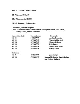
An area east of the Atkinson excavations was also opened for testing in 2004. This area was designated as Atkinson II and a test block was opened and fenced off from the cattle with snow fence. A 4m2 block was surveyed in (units 13 - 16) and two partial units that were truncated by the riverbank (units 11 &12) were also placed to the south of the 4m2 block. Test units 9 and 10 were also excavated.
Field journals have been scanned in multi-page PDF files. Artifact catalogues are PDF files in spreadsheet format. Photographs are in jpeg format.
History / Biographical
After the flooding of the Souris River in 2004 receded, Tomasin Playford and her crew of Andrea Richards, Sarah Graham and Shane Kolesar returned to the Atkinson site and commenced cleaning up the earlier excavation of Atkinson.
An area east of the Atkinson excavations was also opened for testing in 2004. This area was designated as Atkinson II. In some of the field notes it is referred to as Atkinson East. A test block was opened and fenced off from the cattle with snow fence. A 4m2 block was surveyed in (units 13 - 16) and two partial units that were truncated by the riverbank (units 11 &12) were also placed to the south of the 4m2 block.
Three of the students who had completed the recent field school were hired as crew. Jessica McKenzie, Evie Fevez and Emily Ansell joined the crew at the Atkinson II site.
Recoveries from XU 13 - 16:
Large bison bone was recovered from units 11 and 12 and a metal tobacco box seal was recovered from unit 12. More small pieces of metal found in levels 2 and three together with small bone fragments. A bone fragment with butchering marks from a metal tool was recovered from level 6 and pottery was found in level 9. A few lithic flakes were found in level 13 and in a trench at the bottom of unit 13 above a calcite cemented layer. Recoveries from these tests were sparse and diminished as the excavation series became more distant from the river. It is likely that the remains that were recovered represent the northern edge of these occupations.
The upper occupation at Atkinson II appears to be an early historic occupation with a sparse scatter of bone and a few pieces of metal. The lower layers, below level 7 are likely precontact. Units 9 and 10 were dug as test pits and produced very little in the way of cultural materials.
Scope and Content
Sub-sub-sub series contains: Summary information of field methology, number and co-ordinates of excavations, personnel and their staff position; Field journals are daily records of recoveries, features and activities at the site; Site records include excavation level and unit summaries, feature sheets, profiles; sample records and maps; Artifact catalogues are lists and identifications of all artifacts recovered; Photographs are of excavation units, features, the landscape and personnel.
Field journals have been scanned in multi-page PDF files. Artifact catalogues are PDF files in spreadsheet format. Photographs are in jpeg format
History / Biographical
Based on the results of the testing in 2002 and the radiocarbon date of 6,400 years before present, further excavation was warranted at the Atkinson I site. In 2003 Field Chief Holly Alston and crew Shayne Kolesar and Andrea Richards opened a 42m test excavation (units 1 - 4) that included the hearth area.
The unit co-ordinates and excavator are listed on the attached pdf file.
Field journals have been scanned in multi-page PDF files. Artifact catalogues are PDF files in spreadsheet format. Photographs are in jpeg format
History / Biographical
Based on the results of the 2003 excavation, and the radiocarbon date of 6,200 years before present, further excavation was warranted at the Atkinson I site.
In 2004 four units (5, 6, 7, & 8) were surveyed in adjacent to the 2003 units. The unit co-ordinates and excavator are listed on the attached pdf file.
Field journals have been scanned in multi-page PDF files. Artifact catalogues are PDF files in spreadsheet format. Photographs are in jpeg format.
History / Biographical
Based on the results of the testing in 2002 and the radiocarbon date of 6,500 years before present, further excavation was warranted at the Atkinson site. In 2003 Field Chief Holly Alston and crew Shayne Kolesar and Andrea Richards opened a 42m test excavation (units 1 - 4) that included the hearth area.
The site area was covered with a huge sand dune that was slowly sliding into the river as the supporting bank eroded away. As the dune was removed a late woodland camp was found at the dune interface and a large chunk of charcoal dated this occupation to 440+/-60 B.P. cal.1440A.D. This indicated that the dune was a relatively late incursion over the site. This occupation is likely connected to subsequent testing to the east in 2005 that came to be known as Atkinson II.
Methodology:
The crew began shovel shaving the upper strata with the intention of establishing an arbitrary datum when artifacts were encountered or when a level 25cm above the hearth was reached. At 25cm above the hearth an arbitrary surface datum was established and excavation in 5cm levels began. The overbank deposited matrix was a dense, compacted silt clay and it was necessary to soak the excavated materials in buckets and then water screen the material with a high pressure pump over ¼ inch hardware cloth.
Lithic flakes were found at 10cm below datum, above the hearth level. In the next level, large bone, a broken projectile point and additional flakes were found. Increasing amounts of bone and lithic flakes were found as the excavation continued through levels 3 to 5. The top of the hearth was identified at 28cm below datum, below a 2cm layer of well-sorted sand. This sand layer was confined to a small area directly overlying the hearth. It was considered to be a deliberate quenching of the hearth.
After the conclusion of excavating level 6 the hearth was profiled and photographed. The charcoal and ash layer of the hearth was shown to be directly below the sand layer. Levels 6 and 7 revealed a bison bone bed that was consistent with primary and secondary butchering including elements from the vertebral column and appendicular skeleton. Two additional Gowen (Mummy Cave Series) projectile points were also recovered adjacent to the hearth. Level 8 continued to produce larger amounts of bone and many lithic flakes. Level 9 produced a few bone fragments and a small number of lithic flakes. At the conclusion of the excavations, the crew shoveled sand down from the dune to protect the site over winter and through any subsequent spring flooding.
Scope and Content
Sub-sub-sub series contains: Summary information of field methology, number and co-ordinates of excavations, personnel and their staff position; Field journals are daily records of recoveries, features and activities at the site; Site records include excavation level and unit summaries, feature sheets, profiles; sample records and maps; Artifact catalogues are lists and identifications of all artifacts recovered; Photographs are of excavation units, features, the landscape and personnel.
Field journals have been scanned in multi-page PDF files. Artifact catalogues are PDF files in spreadsheet format. Photographs are in jpeg format.
History / Biographical
In 2004 Tomasin Playford and her crew of Andrea Richards, Sarah Graham and Shane Kolesar cleared sand cover from over the 2003 excavations and extended sand clearing back from the north edge of the 2003 units to permit implementation of four additional units. During this sand clearing a hearth was identified together with small numbers of lithics and pottery body sherds. This occupation had been noted during sand clearing in 2003 and a charcoal sample was collected and radiocarbon dated to 1440 A.D. This hearth was assigned to Atkinson II, a later occupation.
Four units (5, 6, 7, & 8) were surveyed in adjacent to the 2003 units. Excavation proceeded by means of shovel shaving until the datum pegs from the previous year were located. The new units were then given datum pegs and string boundaries and the high pressure pump was set up for water screening of silt/clay matrix.
Continued to shovel shave levels 1 - 4 and recovered small burned and unburned bone fragments. Level 5 produced a projectile point, an end scraper and a large heat-treated Swan River Chert (SRC) flake. Other SRC flakes were also recovered. Levels 6 and 7 yielded large numbers of flake debitage. The matrix in levels 5-7 contained a scatter of small, bright red ochre particles. The river began to rise on the ninth of June and the site was sandbagged on June 11th, temporarily bringing an end to excavation for Atkinson 1. Tomasin and her crew were relocated to the Crepeele site, west of Lauder.
On July 20th, Tomasin and her crew returned to the Atkinson site and commenced cleaning up the earlier excavation following the flooding. Following the clean up, excavations were resumed on the units that had been opened. An additional Gowen point was recovered from level 8 as well as some poorly preserved bison bone. A lot flakes and small amounts of bone were recovered on west side of block and larger bone and flakes in bone bed along the east side in levels 8 - 10. Two bifaces were recovered in level 11 and a third in level 13. The excavations were terminated at level 18 when water started coming up through the unit floors.
Scope and Content
Sub-sub-sub series contains: Summary information of field methology, number and co-ordinates of excavations, personnel and their staff position; Field journals are daily records of recoveries, features and activities at the site; Site records include excavation level and unit summaries, feature sheets, profiles; sample records and maps; Artifact catalogues are lists and identifications of all artifacts recovered; Photographs are of excavation units, features, the landscape and personnel.
Field journals have been scanned in multi-page PDF files. Artifact catalogues are PDF files in spreadsheet format. Photographs are in jpeg format.
History / Biographical
The Atkinson site had been flooded in 2005 and there was concern about the amount of damage that might have occurred. A small crew of Tomasin Playford, Michelle Drysdale and Jessica McKenzie returned to the Atkinson site with the goals of obtaining a detailed profile of the stratigraphy at the north end of the occupation and to determine if the site extended contiguously towards the east. Two test pits were planned as well as the investigation of a couple of hearths found eroding from the riverbank Work commenced July 4th and finished July 21st.
To the north of XU 8 (Gowen occupation) an excavation unit 18 was opened and shovel shaved to a depth of 200cm. At 195cm below surface a point bar deposit was identified indicating that any lower occupations would likely have been eroded by an earlier channel cutting event prior to formation of this point bar depositional event. Golf tees were inserted into the edge of the profile to indicate the 5cm levels superimposed on a digital photo of the section. Lithic flakes and bone fragments were scattered thoughout the stratigraphic column. A radiocarbon date of 440 B.P. was obtained from the unit, indicating a much later occupation than Gowen.
Unit 19 was excavated but only yielded a small Besant component containing a small hearth (H#3) In level 9, a point tip and a small biface as well as a few undecorated pot sherds were recovered. These two units defined the extent of the Atkinson I site. An unknowable area of the site has been eroded away by the encroaching Souris River.
The two small exposed hearths were excavated but only yielded a small amount of material. Hearth 4, at the western edge of the Atkinson block yielded only a small amount of charcoal , mixed with burnt bone and a few small lithic flakes. Hearth 5, located in the high cut bank west of the main site yielded a small amount of bone from a small ungulate, a muskrat and a bird as well as a percussion cap. This latter recovery indicated that this was an early historic period site.
Scope and Content
Sub-sub-sub series contains: Summary information of field methology, number and co-ordinates of excavations, personnel and their staff position; Field journals are daily records of recoveries, features and activities at the site; Site records include excavation level and unit summaries, feature sheets, profiles; sample records and maps; Artifact catalogues are lists and identifications of all artifacts recovered; Photographs are of excavation units, features, the landscape and personnel.
Born on February 10, 1924, in Elgin, Manitoba, Audrey Ellen Silvius (nee Honeyman) was raised in Fairfax, Manitoba on the Honeyman homestead. In 1964, she received her Indian name, Blue Star. Silvius completed her high school education in Fairfax before moving to Winnipeg in 1943, to earn her Nursing degree from Grace Hospital. She later completed her post-graduate degree in Psychiatric Nursing at the Brandon Mental Health Centre. Married to Merritt W. Silvius, Audrey Silvius raised four children, David, Kay, Lorna (Downie) and Gail (Campos) while working in her chosen field. In addition to her family and her career, she was also involved with the Brandon Council of Women and the United Church in Brandon. Silvius was the first executive director of the Brandon Indian-Metis Friendship Centre, a founding member of the local branches of the Marquis Project and Amnesty International and initiated a project called Tools for Peace. She was also involved in various other peace and human rights organizations. In 1987, she received the Order of the Buffalo Hunt from the Province of Manitoba in recognition of her work relating to women’s issues. In 1992, she was awarded a Confederation medal for community service.
Custodial History
The records found within the collection were collected by Audrey Silvius from a number of people, including Jean Halliday, Grace Godmaire and Norma Walmsley, involved in various projects with her throughout the years. Prior to their donation to the McKee Archives at Brandon University in October and November 2000, the records were stored at Mrs. Silvius’ home.
Scope and Content
Collection consists of meeting minutes, agendas, speeches, correspondence, newsletters, brochures, written publications and newspaper clippings. Four photographs and one pencil drawing are also included within the collection.
The records deal with the creation, activities, and history of the Brandon Indian-Metis Friendship Centre, as well as the activities of its Board of Directors. In addition, materials located within the collection can be divided into two areas: (1) those that relate to various organizations associated with the Friendship Centre itself, such as the Council of Christians and Jews and the Brandon Council of Women; (2) materials related to projects of important individuals involved with the Friendship Centre, such as the South Western Manitoba Recreation Council and the 4F Club of Minnedosa. Other records deal with general aboriginal issues in Canada during the time frame of the Audrey Silvius collection.
Notes
CAIN No. 202607. Description by Christy Henry (2000).
The collection is divided into ten (10) series:
1. The Brandon Indian-Metis Friendship Centre
2. The Scout – Friendship Centre newsletter
3. The Brandon Council of Women
4. Council of Christians and Jews
5. Aboriginal Glee Club/Dancers
6. The South Western Manitoba Recreation Council
7. 4F Club of Minnedosa
8. Miscellaneous Publications related to Aboriginal Issues
9. Miscellaneous Newspaper Clippings related to Aboriginal Issues
10. Photographs and pencil drawing
A number of the letters are samples of "cross writing"
Physical Condition
Some of the letters are fragile, but generally the fonds is in good condition.
Custodial History
Ann Murdoch donated a copy of "My Dear Will" to the McKee Archives in February 2008. The formal donation of the Baker family letters occurred on September 27, 2008 at a reception in the Gathering Space at the John E. Robbins Library.
Scope and Content
Fonds consists of a collection of about 200 letters primarily written by William Baker (although letters written by other family members are also included), who left Liverpool and settled in Oak Lake, to his son William who remained in England. The letters offer insights on a wide range of subjects including the conditions of immigrants and the Riel "situation".
The fonds also contains a supplement to "My Dear Will: Reflections of Prairie Pioneer Life." This latter publication consists of transcribed copies of the letters in the Baker family fonds. The letters were originally transcribed by Ronald James Parsons and his wife Rita Olive Parsons (nee Blake) and published, along with some letters, photographs and other documents for family c. 1997. The booklet was updated in 2007 by Ronald and Rita's daughter, Ann Murdoch. The Supplement was prepared by Ann Murdock and her sister Dawn Powell.
Notes
Description by Christy Henry.
Finding Aid
My Dear Will booklet
Storage Location
2008 accessions. Booklets and family tree stored in Rare Books: RC 3399.B73Z495 2007 v.1 and v.2.
Bankburn School was located 1/2 mile west and about three miles north of Oak River, Manitoba. The Bankburn School Literary Society was formed in 1906.
Custodial History
Records were donated to the McKee Archives by Anne Pettapieces in March 1978.
Scope and Content
Fonds consists of the minutes of the Literary Society of the Bankburn School (1906-1907) and a copy of Vol.1, No.1 of The Bankburn Star, which includes some information on and two photos of the school.
The OddFellows has a long international history as a mutual assistance society for men. OddFellow Lodges were open to white males over the age of 21, who were in good health and possessed good moral character. Upon joining an OddFellow's Lodge, a member received social and financial benefits. The Constitution of the Subordinate Lodges in Manitoba, 1899, notes that OddFellows Lodges were obliged to teach the importance of fraternity. Under the organization's constitution, lodge members assumed five obligations: to visit the sick, to relieve the distressed, to bury the dead, to educate the orphan, and to aid the widow. The Progress Lodge of the Basswood OddFellows was created in 1910; it continued as a group until early 1955, when it amalgamated with the Minnedosa OddFellows. The Progress Lodge of the Basswood OddFellows included men of many different occupations and social classes including, farmers, merchants, ministers, teachers, agents, carpenters, grain buyers, clerks, and laborers.
Custodial History
The records of the Basswood Oddfellows Lodge were in the possession of Donald McNabb, who for many years was an active member of the Minnedosa Oddfellows. He donated the records to the McKee Archives in June 2000.
Scope and Content
Fonds consists of five books. The first book is a membership list from 1910-1948. The list includes the members' names and occupations, the date that they joined the lodge, and their status within the hierarchy of the lodge. The other four books consist of minutes for the years 1910-16, 1916-25, 1935-44, and 1945-54.
Administrative history for the Basswood School District is currently unavailable.
Custodial History
Accessioned in 2007 by the McKee Archives. Prior custodial history is unknown.
Scope and Content
Fonds consists of van driver contracts (1916-33), income tax forms (1919-38), school inspector's reports (1922-29), high school examination results (1926-34), correspondence with Western Seating Co. (1922), school censuses (1919-38), bus route plans (1916-34), caretaker agreemtns (1918-33), transportation expenditure forms (1917-38), equalizaton of taxes forms (1916-34), annual meeting reports (1924, 1927), Department of Education reports (1921-38), secondary school taxes notice to council forms (1926-33), Manitoba income tax employers' returns (1923-32), library reports (1929-34), requisitions for library books (1916-30), assessments (1919-34), teacher's annual reports (1937-38) and a miscellaneous file including records related to pupil promotions, teacher's retirement fund, religious teaching, a hectograph recipe, by-laws and insurance (1922-38).
Notes
Receipts from 1938-1939 were culled. Description by Christy Henry.
Métis fiction writer Beatrice Culleton Mosionier was born in the St. Boniface area of Winnipeg, Manitoba, in 1949 and after some time in Toronto, she moved back to Winnipeg. She attended George Brown College, 1970, and Banff School of Fine Arts, 1983. Aside from writing, Beatrice worked for a number of years at Pemmican Publications, a Manitoba publishing house. She has written works of fiction aimed at both adults and children.
Custodial History
Both drafts were sent to Sam Corrigan, Native Studies Department, Brandon University, by Greg Young-Ing, Managing Editor of Theytus Books in August 2001 for deposit in the Archives.
Scope and Content
Fonds consists of the first draft (galley draft) and the final edit of "In the Shadow of Evil" by Beatrice Culleton Mosionier. It also includes a press release from Theytus Books Ltd. regarding the publication of the novel.
Notes
History/Bio information taken from the Manitoba Author Publication index at http://www.mbwriter.mb.ca/mapindex/m_profiles/mosionier_b_c.html (February 2007) and the Native American Authors Project at http://www.ipl.org/div/natam/bin/browse.pl/A34 (February 2007).
The name Berbank was created by combining the names of two local districts: Riverbank and Bertha. Both were located south of Brandon in the Rural Municipality of Oakland. The Berbank Church was built in 1919. Its construction grew out of the work of the Berbank Red Cross founded in 1917. The Berbank Church was a "union" church, constructed in anticipation of the formation of the United Church of Canada. In 1966, the Berbank congregation joined with the Nesbitt congregation to operate out of the Nesbitt United Church. The final service at the Berbank United Church was held in 1966.
Custodial History
This fonds was accessioned by the McKee Archives in 1997. Prior custodial history is unknown.
Scope and Content
Fonds contains a document titled "Berbank Church History." This document is partially in a printed format with a portion handwritten. Fonds also contains minute books and legal documents pertaining to the ownership of the land upon which the Church was constructed.
Berbank Women's Aid was founded in 1919. It was, in large part, the Berbank Red Cross under a new name. The principal project of the original Berbank Ladies Aid was the construction of the Berbank Church, which was accomplished in 1919. In 1962, the organization was renamed the Berbank United Church Women. With the closing of the Berbank church in 1966, the Berbank United Church Women were dissolved.
Custodial History
This fonds was accessioned by the McKee Archives in 1997. Prior custodial history is unknown.
Scope and Content
This fonds consists of various minute books of the Berbank Ladies Aid, and its successor organization, dating from 1919 to 1965.