Sub-series consists of various artifacts from Brandon College and Brandon University that can loosely be classified as apparal and insignia. It includes beanies, sweaters, jackets, badges, pins, buttons, rings, and crests.
Storage Location
RG 6 Brandon University fonds
Series16: Brandon University/College artifacts
Sub-series consits of a variety of artifacts from Brandon College and Brandon University that do not fall into the catagories of flags/banners or apparel/insignia. It includes, plates, trophies, ceremonial spades, inkwells, spoons, the Lady Stick, honour rolls for both World Wars, medallions, keys, public art (sculptures, art installations), paintings and the Prairie College cairn.
Storage Location
RG 6 Brandon University fonds
Series16: Brandon University/College artifacts
Located in display case, artifact box in the stacks and oversized envelope storage.
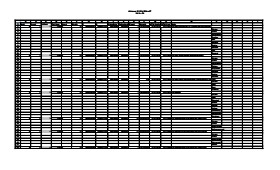
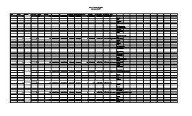
Artifact catalogue containing 455 records from Atkinson II site 2004.
Scope and Content
Spreadsheet containing information about the artifacts recovered, including: unit, level, artifact number, catalogue number, depth, co-ordinates, entry date, date recovered,count, weight, UTM co-ordinates, notes(excavators initials and comments) and artifact identification.
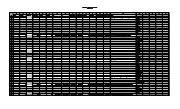
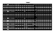
Artifact catalogue containing 646 records from Atkinson site 2003.
Scope and Content
Spreadsheet containing information about the artifacts recovered, including: unit, level, artifact number, catalogue number, depth, co-ordinates, entry date, date recovered,count, weight, UTM co-ordinates, notes(excavators initials and comments) and artifact identification.
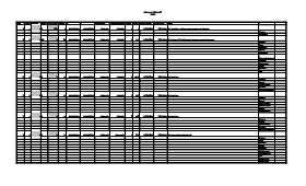
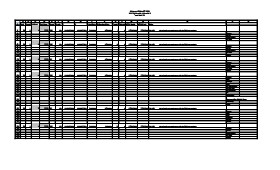
Artifact catalogue containing 556 records from Atkinson site 2004.
Scope and Content
Spreadsheet containing information about the artifacts recovered, including: unit, level, artifact number, catalogue number, depth, co-ordinates, entry date, date recovered,count, weight, UTM co-ordinates, notes(excavators initials and comments) and artifact identification.
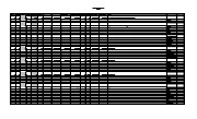
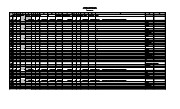
Artifact catalogue containing 343 records from Atkinson site 2006.
Scope and Content
Spreadsheet containing information about the artifacts recovered, including: unit, level, artifact number, catalogue number, depth, co-ordinates, entry date, date recovered,count, weight, UTM co-ordinates, notes(excavators initials and comments) and artifact identification.
The Atkinson site was named for the landowners Ken and Karen Atkinson who were very helpful to the archaeology and geoarchaeology crews that worked at the site. Their support made the project possible.
The Atkinson site story begins with the discovery of a charcoal lens eroding from the north bank of the Souris River in the summer of 2002. Study of Cultural Adaptations on the Prairie Ecozone (SCAPE) project geoarchaeologist Dr. Garry Running was exploring the stratigraphic layering in the bank when he noted the lens and reported it to Dr. Bev Nicholson. Upon closer examination, a tiny pressure flake was observed on the lens exposure and it was decided to collect a charcoal sample for radiocarbon dating.
The resulting date of 5250B.P cal. 4225 B.C. placed the site in the early Archaic period. A second date on bone collagen of 5580B.P. cal. 4500 B.C. confirmed the earlier date and gave an averaged date of circa 4400 B.C or 6,500 years ago.
The Atkinson site is one of the oldest excavated sites in Manitoba. Based on the date of the site and the kind of lithics (stone tools) present it is considered a Gowen occupation. The Atkinson site is evidence that bison hunters were active on the northern plains at a very early date. Similar sites have also been found on the High Plains in the U.S. and are referred to as the Mummy Cave Complex.
The Atkinson Site is of great importance as it is the first undisturbed site of this type to be excavated in Manitoba and extends the range of these sites south and east from the type-sites in central Saskatchewan. Based on the date and sample evidence further excavations were conducted by Dr. Nicholson's team. in 2003, 2004 and 2006.
Scope and Content
Sub series has been divided into three sub sub series including: (1) Atkinson 2003, (2) Atkinson 2004; (3) Atkinson 2006
Bertha Miriam Clark was born on Prince Edward Island but attended public and high school in Brandon, MB. She was a member of the Class of 1929 and served as Lady Stick in her final year at Brandon College.
Clark married J. Scott Leith, Brandon College Class of 1928. Scott and Bertha Leith's son James Clark Leith is in the Canadian Who's Who.
Custodial History
Album was sent to Pat Britton, Brandon University Director of Alumni Relations, by Bertha Leith in April 1991. Britton then transferred it to the McKee Archives.
Scope and Content
Fonds consists of a small accordian style photograph album (7 x 10.5 x 3.5 cm) created by Bertha Clark during her years at Brandon College. The photographs, which measure 4" x 2.75", depict numerous people and events.
Notes
History/Bio information taken from the 1928-1929 Sickle.
The high biodiversity and evidence of pre-Europeon contact prompted the decision to test the Crepeele locale. The survey was named in recognition of the Casselman family, the original landowners.
Archaeological testing began in the Crepeele locale in May 2003 on property now owned by the Crepeele family. The locale covers over 6 sections or approximately 3,800 acres of land in an area of stabilized sand dunes and wetlands covered with mixed forest and prairie grass. Given the terrain, the size of the crew and time constrains, an area of approximately 60 acres was chosen for the survey. The survey used the established archaeological methodology of walking the selected area and using a shovel test surveyed grid. The use of GIS technology to locate the exact test spot and record the information into a GIS database was a significant advance and was one of the advantages of the integration of multi-disciplinary techniques encouraged by the SCAPE project. Over one half of the test pits resulted in the recovery of cultural materials. The results of the Casselman survey indicated several areas for further examination including areas that became the Crepeele, Sarah and Graham sites.
Scope and Content
Sub sub series has been divided into five sub sub sub series including: (1) Summary information; (2) Field journals; (3) Site records; (4) Artifact catalogues; and (5) Photographs.
Radiocarbon date reports have been scanned in multi-page PDF files.
History / Biographical
The Crepeele locale is located within the larger Lauder Sandhills area, located in southwestern Manitoba. The area is a complex region of high biodiversity made up of stabilized sand dunes and wetlands that encourage the development of mixed forest and grass prairie. This area provided a variety of subsistence resources for pre-European hunter-gatherers. At the present time the grass prairie is now farm land but the areas of vegetated sand dunes have not been cultivated and have revealed numerous pre-contact archaeological sites.
Archaeological surveying was conducted in 2003. The results of the 2003 Casselman survey showed over 300 test uints contained cultural material and indicated several areas for further examination including the Crepeele site DiMe-29, Sarah site DiMe-28 and Graham sites DiMe-30.
From 2003 to 2008 field work took place at the locale with 75 - 1m x1m units excavated. The Crepeele locale is a complex region of high biodiversity made up of stabilized sand dunes and wetlands that encourage the development of mixed forest and grass prairie. This area provided a variety of subsistence resources for pre-European hunter-gatherers. At the present time the grass prairie is now farm land but the areas of vegetated sand dunes have not been cultivated and have revealed numerous pre-contact archaeological sites.
To help establish the cultural sequence at the locale Radiocarbon dates were obtained from the three sites in the Crepeele locale.
Radiocarbon dating
The technique of radiocarbon dating was developed by Willard Libby and his colleagues at the University of Chicago in 1949.
Radiocarbon dating is used to estimate the age of organic remains from archaeological sites. Organic matter has a radioactive form of carbon (C14) that begins to decay upon death. C14 decays at a steady, known rate of a half life of 5,730 years. The technique is useful for material up to 50,000 years. Fluctuations of C14 in the atmosphere can affect results so dates are calibrated against dendrochronology. Radiocarbon dates are calibrated to calendar years.
Dates are reported in radiocarbon years or Before Present. Before Present refers to dates before 1950. The introduction of massive amounts of C14, due to atomic bomb and surface testing of atomic weapons, has widely increased the standard deviation on all dates after A.D. 1700 causing these dates to be unreliable.
Accelerated mass spectrometry can more accurately measure C14 with smaller samples and can date materials to 80,000 years.
Scope and Content
Sub sub series contains radiocarbon dates from: Crepeele, Sarah and Graham sites.
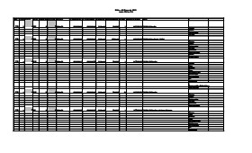
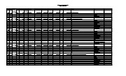
Artifact catalogue containing 636 records from Crepeele site 2003.
Scope and Content
Spreadsheet containing information about the artifacts recovered, including: unit, level, artifact number, catalogue number, depth, co-ordinates, entry date, date recovered,count, weight, UTM co-ordinates, notes(excavators initials and comments) and artifact identification.
Field journals have been scanned in multi-page PDF files.
History / Biographical
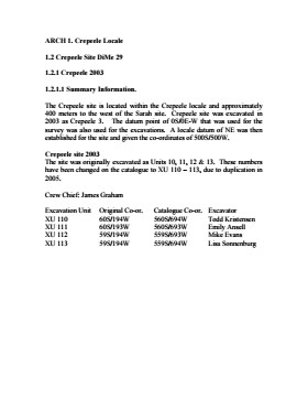
The Crepeele site was excavated in 2003 as Crepeele 3. Standard archaeological methods were used to excavate the units. Excavation units were initially numbered as units 10, 11, 12 & 13. These numbers have been changed on the catalogue to XU 110 – 113, due to duplication in 2005. Corresponding documents have been changed to reflect the amended excavation unit numbers, however the field journals may contain the initial numbers.
Scope and Content
Record of daily observations at the site including: excavation methods, items recovered, features, local environment and weather.
Numerous photographs were taken during the excavation of the Crepeele site 2003. A selection of photographs of personnel performing usual field tasks such as surveying, measuring, excavating, and taking photographs were selected for the archive.
Scope and Content
Sub sub sub series consists of photographs taken during excavation of the Crepeele site 2003.
Site records have been scanned in multi-page PDF files.
History / Biographical
The Crepeele site was excavated in 2003 as Crepeele 3. Standard archaeological methods were used to excavate the units. Site records of excavation units XU 110 – 113 are in seperate pdf files.
Scope and Content
Site records of excavation units may include: level summaries, floor plans, feature sheets, wall profiles, unit summaries and any other additional information relating to the unit.
Field journals have been scanned in multi-page PDF files. Artifact catalogues are PDF files in spreadsheet format. Photographs are in jpeg format.
History / Biographical
The Crepeele site was identified from the results of the Casselman survey. The site is located within the Crepeele locale approximately 400 meters to the west of the Sarah site. The units were excavated by Crew Chief James Graham and the crew from the survey.
The Crepeele site was excavated in 2003 as Crepeele 3 with the units numbered as units 10, 11, 12 & 13. These numbers have been changed on the catalogue to XU 110 – 113, due to duplication in 2005. Corresponding documents have been changed but there may be some reference to the initial numbers in the field journals.
The artifacts recovered from these four excavations are faunal (animal bone), mainly bison, lithic materials (stone tools and flakes) and some ceramic (pottery). The artifact catalogue has over 600 records.
Scope and Content
Sub-sub-sub series contains: Summary information of field methology, number and co-ordinates of excavations, personnel and their staff position; Field journalsare daily records of recoveries, features and activities at the site; Site records include excavation level and unit summaries, feature sheets, profiles; sample records and maps; Artifact catalogues are lists and identifications of all artifacts recovered; Photographs are of excavation units, features, the landscape and personnel.
Numerous photographs were taken during the excavation of the Crepeele site 2004. A selection of photographs of features and personnel performing usual field tasks such as surveying, measuring, excavating, and taking photographs were selected for the archive.
Scope and Content
Sub sub sub series consists of photographs taken during excavation of the Crepeele site 2004.
Site records have been scanned in multi-page PDF files.
History / Biographical
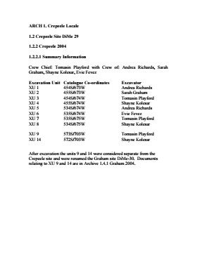
The Crepeele site was identified from the results of the Casselman survey and excavated in 2003. In 2004 the site was funded through the SCAPE project, directed by Bev Nicholson. The units were excavated by Crew Chief Tomasin Playford and crew.
Eight units were excavated in 2004, XU 1 to XU 8. Each unit has a seperate pdf file.
Scope and Content
Site records of excavation units may include: level summaries, floor plans, feature sheets, wall profiles, unit summaries and any other additional information relating to the unit.
Field journals have been scanned in multi-page PDF files. Artifact catalogues are PDF files in spreadsheet format. Photographs are in jpeg format.
History / Biographical
The Crepeele site was identified from the results of the Casselman survey and excavated in 2003. Further units 1 to 8 were excavated in 2004. Funding was through the SCAPE project, directed by Dr. Bev Nicholson. The site was excavated by Crew Chief Tomasin Playford and crew.
Scope and Content
Sub-sub-sub series contains: Summary information of field methology, number and co-ordinates of excavations, personnel and their staff position.