Skip header and navigation

Revise Search

20 records – page 1 of 1.

Park Street School

http://archives.brandonu.ca/en/permalink/descriptions14316
Part Of
Brandon and Area Photograph Collection
Description Level
Item
GMD
graphic
Date Range
[after 1905]
Part Of
Brandon and Area Photograph Collection
Description Level
Item
Series Number
2
Item Number
BAPC 2.42
GMD
graphic
Date Range
[after 1905]
Physical Description
5.5" x 3.5" (color)
Material Details
Postcard
History / Biographical
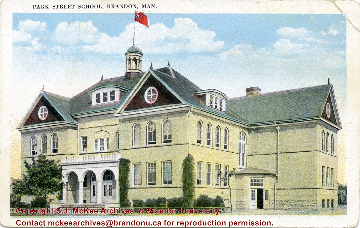
Located south of Stanley Park along the 1400 block of Lorne Avenue, Park School was constructed in 1904. Designed by W.A. Elliot and built by the Brandon Construction Company the structure measured 71 x 107 feet and cost approximately $38,000. The school featured a principal’s office, reception room, staff rooms, an assembly hall for eight hundred, and ten class rooms. The interior walls were lined with mahogany while the floors were made of western pine. The interior of the basement was constructed from Tyndall stone, while Crookston brick trimmed with Bedford stone made up the exterior. The building was razed in September 1978. Hobbes Manor was built on the location.
Scope and Content
Item is a postcard showing Park School in Brandon, MB.
Name Access
Park School
Subject Access
schools
Education
Storage Location
BAPC photograph drawer
Images
Show Less

The Railway foreman's children

http://archives.brandonu.ca/en/permalink/descriptions13510
Part Of
Brandon and Area Photograph Collection
Description Level
Item
GMD
graphic
Date Range
June 1911
Accession Number
3-2014
Part Of
Brandon and Area Photograph Collection
Description Level
Item
Series Number
5
Item Number
BAPC 5.10
Accession Number
3-2014
GMD
graphic
Date Range
June 1911
Physical Description
3.5" x 5.5" (b/w)
Material Details
Postcard
Physical Condition
Excellent
History / Biographical
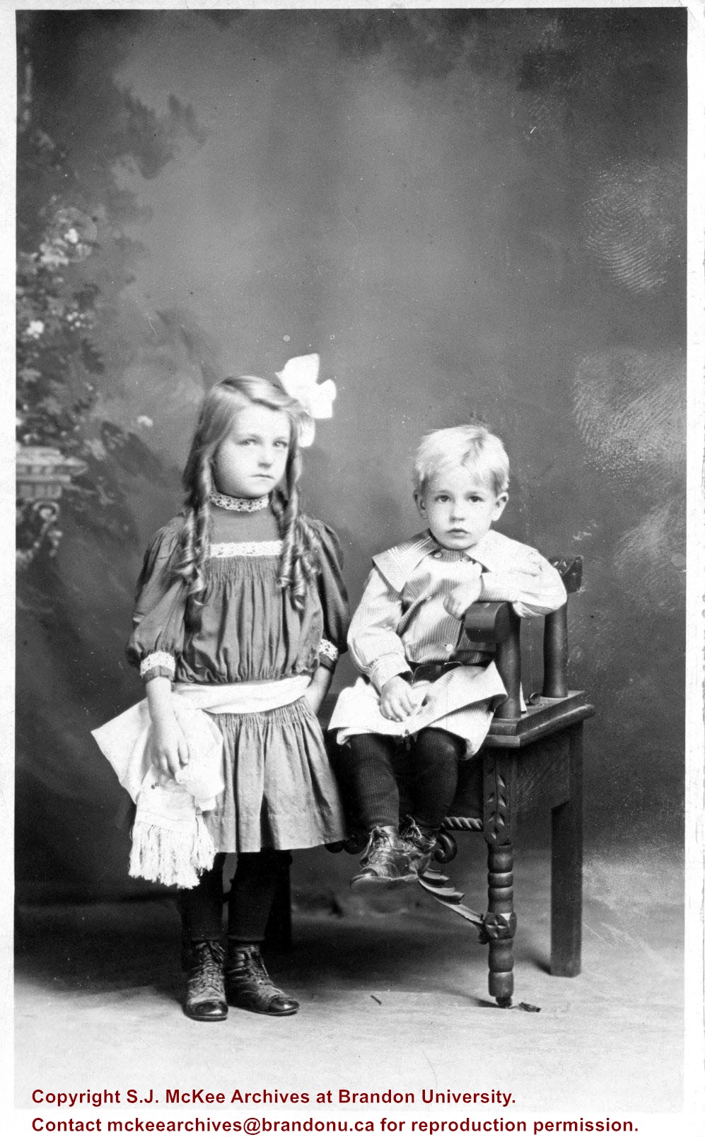
Alfred Walter Pryce was born in England c. 1880. He emigrated from England in 1903 and was hired by the Canadian Pacific Railway, likely in Manitoba. His wife, Kate Louisa Buchan, was older than her husband. She was born in England c. 1873. They were married in England? and she followed her husband to Canada in 1904. Alma Jane Pryce was born June 24, 1905 and Herbert Walter Pryce was born May 12, 1907 in [Elton] Manitoba. In autumn 1911, the Pryce family returned to England for a Christmas visit. They sailed from Halifax on the Empress of Britain and arrived in Liverpool on December 9, 1911. The family returned to Canada on the Empress of Ireland from Liverpool in early 1912, landing at St. John, New Brunswick. Alfred Walter Pryce died in Brandon, MB on January 31, 1922. Kate Pryce died in Winnipeg, MB on March 18, 1938.
Custodial History
Donated to the McKee Archives by Jennifer L. Bunting in November 2013.
Scope and Content
Studio portrait of Alma and Herbert Pryce, The Railway Foreman's children, taken June 1911 in Kenora, ON. Writing on the back reads: To Granfather with Love from Herbert and Alma. Alma Jane Pryce Age 6 years. Herbert Walter Pryce Age 3 years 5 months. Keonra, Ont. Canada. June 1911.
Notes
History/Bio information provided by Jennifer Bunting. Additional information is available in the custodial file.
Name Access
Alma Pryce
Herbert Pryce
Alfred Pryce
Kate Louisa Buchan
Kate Louisa Pryce
Subject Access
portraits
Storage Location
BAPC photograph drawer
Images
Show Less
Part Of
Brandon and Area Photograph Collection
Description Level
Item
GMD
graphic
Date Range
c. 1900
Part Of
Brandon and Area Photograph Collection
Creator
Photographer: W.A. Martel & Son
Description Level
Item
Series Number
5
Item Number
BAPC 5.11
GMD
graphic
Date Range
c. 1900
Physical Description
4" x 5.5" (b/w)
Physical Condition
Very good
History / Biographical
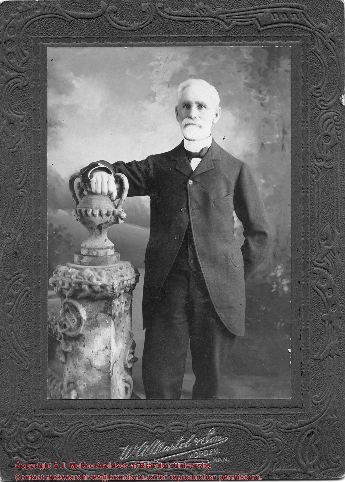
William Currie was born on February 28, 1834 in Lanark County, ON. In 1860, he moved to St. Mary's, where he worked in mercantile and grain businesses until 1879, when he emigrated to Manitoba. The following year, he took up homesteading along the Assiniboine River, at a site known as Currie's Landing. He received and forwarded frieght from steamboats travelling the river. From 1893-1902, he served as baliff for the Brandon District, before resigning and moving to Brandon where he engaged in the real estate and fire insurance business. Currie married Ellen Creighton of Blanchard, ON in 1861. Together they had six chrildren: Robert Wilson Currie, Margaret Anne Currie, Harriet Ellen Currie, William James Currie, James Weldon Currie, and Lottie Louise Currie. William Currie died on March 30, 1931 in Brandon, MB.
Scope and Content
Item is a studio portrait of William Currie.
Notes
History/Bio information taken from the Manitoba Historical Society website (http://www.mhs.mb.ca/docs/people/currie_w.shtml)
Name Access
William Currie
Currie's Landing
Subject Access
portraits
Pioneers
Storage Location
BAPC photograph drawer
Images
Show Less

Dr. Stuart Schultz

http://archives.brandonu.ca/en/permalink/descriptions14322
Part Of
Brandon and Area Photograph Collection
Description Level
Item
GMD
graphic
Date Range
1956-1957
Part Of
Brandon and Area Photograph Collection
Description Level
Item
Series Number
5
Item Number
BAPC 5.14
GMD
graphic
Date Range
1956-1957
Physical Description
3" x 4.5" (b/w)
History / Biographical
Stuart Duncan Schultz was born on December 24, 1892 in Belmont, MB to Frank Albert Schultz and Margaret Maria MacPhail. He graduated from the Manitoba Medical College and then continued his studies with four years at the London Royal College of Physicians and Surgeons. Schultz served with the 226th Overseas Battalion of the Canadian Expeditionary Force (CEF) during World War I. Schultz returned from England in 1925, at which point he joined the medical staff of the Brandon Hospital for Mental Diseases (later the BMHC). In 1942, he became Superintendent, and in 1959, he retired. During his time in Brandon, Schultz served fourteen years on city council and was Mayor from 1956-1957. He was also the director of the Brandon Schubert Choir for twenty-five years. Following his retirement Schultz moved to Winnipeg where he was the consulting psychiatrist for Stony Mountain Penitentiary. Schultz married Jemima Meiklejohn Gibson on August 30, 1920, in Winnipeg, MB. They had one daughter: Sheilea Schultz Taylor. Stuart Shultz died in Winnipeg, MB on August 10, 1974.
Scope and Content
Item is a portrait of Dr. Stuart Schultz, mayor of the City of Brandon from 1956-1957.
Notes
History/Bio information taken from the Manitoba Historical Society website (http://www.mhs.mb.ca/docs/people/schultz_sd.shtml)
Name Access
Stuart Schultz
Brandon Mental Health Centre
BMHC
Subject Access
mayors
portraits
Storage Location
BAPC photograph drawer
Images
Show Less

Brandon University campus

http://archives.brandonu.ca/en/permalink/descriptions8026
Part Of
Aerial views and campus photographs
Description Level
Item
GMD
graphic
Date Range
c. 1996
Part Of
Aerial views and campus photographs
Description Level
Item
Series Number
2.1
Item Number
2.1.93
GMD
graphic
Date Range
c. 1996
Physical Description
6" x 4" (colour)
Scope and Content
View is east northeast from the sidewalk on the southeast corner of the George T. Richardson Centre (John R. Robbins Library). Photographs shows the campus during winter, including the Physical Plant and Development H-Huts, as well as the Brandon College Building and Clark Hall after the majority of the renovations were completed.
Images
Show Less

Brandon University campus

http://archives.brandonu.ca/en/permalink/descriptions8027
Part Of
Aerial views and campus photographs
Description Level
Item
GMD
graphic
Date Range
c. 1985
Part Of
Aerial views and campus photographs
Description Level
Item
Series Number
2.1
Item Number
2.1.94
GMD
graphic
Date Range
c. 1985
Physical Description
5" x 3.5" (colour)
Scope and Content
View is southwest from 18th Street, just north of the Brandon University sign. Tken during the summer, the photograph shows the front lawn, a portion of the flower bed, the Citizens' Science Building, the Knowles Douglas Students' Union Centre, the John R. Brodie Science Centre and McMaster Hall.
Images
Show Less

Brandon University campus

http://archives.brandonu.ca/en/permalink/descriptions8028
Part Of
Aerial views and campus photographs
Description Level
Item
GMD
graphic
Date Range
c. 1980s
Part Of
Aerial views and campus photographs
Description Level
Item
Series Number
2.1
Item Number
2.1.95
GMD
graphic
Date Range
c. 1980s
Physical Description
5" x 3.5" (colour)
Scope and Content
View is northeast. Photograph shows the green space before the Library extension in 1993. Brandon College Building and the Development H-Hut in the background.
Images
Show Less

Brandon University campus

http://archives.brandonu.ca/en/permalink/descriptions8029
Part Of
Aerial views and campus photographs
Description Level
Item
GMD
graphic
Date Range
c. 1988
Part Of
Aerial views and campus photographs
Description Level
Item
Series Number
2.1
Item Number
2.1.96
GMD
graphic
Date Range
c. 1988
Physical Description
5" x 3.5" (colour)
Scope and Content
View is northwest from the roof of the John R. Brodie Science Centre. Photograph shows part of McMaster Hall, the H-Huts, the Citzens' Science Building, the Brandon College Building and Clark Hall, the driveway, the J.R.C. Evans Lecture Theatre, the A.E. McKenzie Building and the Queen Elizabeth II Music Building.
Images
Show Less

Brandon University campus

http://archives.brandonu.ca/en/permalink/descriptions8030
Part Of
Aerial views and campus photographs
Description Level
Item
GMD
graphic
Date Range
c. early 1990s
Part Of
Aerial views and campus photographs
Description Level
Item
Series Number
2.1
Item Number
2.1.97
GMD
graphic
Date Range
c. early 1990s
Physical Description
4" x 6" (b/w)
Scope and Content
View is north from the Knowles Douglas Students' Union Centre looking down the driveway toward Princess Avenue.
Images
Show Less

Brandon University campus

http://archives.brandonu.ca/en/permalink/descriptions8031
Part Of
Aerial views and campus photographs
Description Level
Item
GMD
graphic
Date Range
c. 1995
Part Of
Aerial views and campus photographs
Description Level
Item
Series Number
2.1
Item Number
2.1.98
GMD
graphic
Date Range
c. 1995
Physical Description
6" x 4" (colour)
Scope and Content
View is northwest from the sidewalk on the west side of 18th Street. Photograph shows the John R. Brodie Science Centre sign, McMaster Hall and its entrance, the lawn in from of McMaster Hall, a portion of the Knowles Douglas Students' Union Centre and the Citizens' Science Building.
Images
Show Less

Brandon University campus

http://archives.brandonu.ca/en/permalink/descriptions8032
Part Of
Aerial views and campus photographs
Description Level
Item
GMD
graphic
Date Range
c. 2000
Part Of
Aerial views and campus photographs
Creator
Photographer: Sandy Black
Description Level
Item
Series Number
2.1
Item Number
2.1.99
GMD
graphic
Date Range
c. 2000
Physical Description
6" x 4" (colour)
Scope and Content
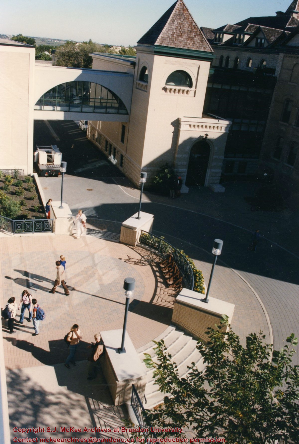
View is southwest from the corner of Clark Hall and the Clark Hall extension. Photograph shows students entering and exiting the George T. Richardson Centre and walking through the courtyard.
Images
Show Less

Brandon University campus

http://archives.brandonu.ca/en/permalink/descriptions8033
Part Of
Aerial views and campus photographs
Description Level
Item
GMD
graphic
Date Range
c. 1990s
Part Of
Aerial views and campus photographs
Description Level
Item
Series Number
2.1
Item Number
2.1.101
GMD
graphic
Date Range
c. 1990s
Physical Description
4" x 6" (colour)
Scope and Content
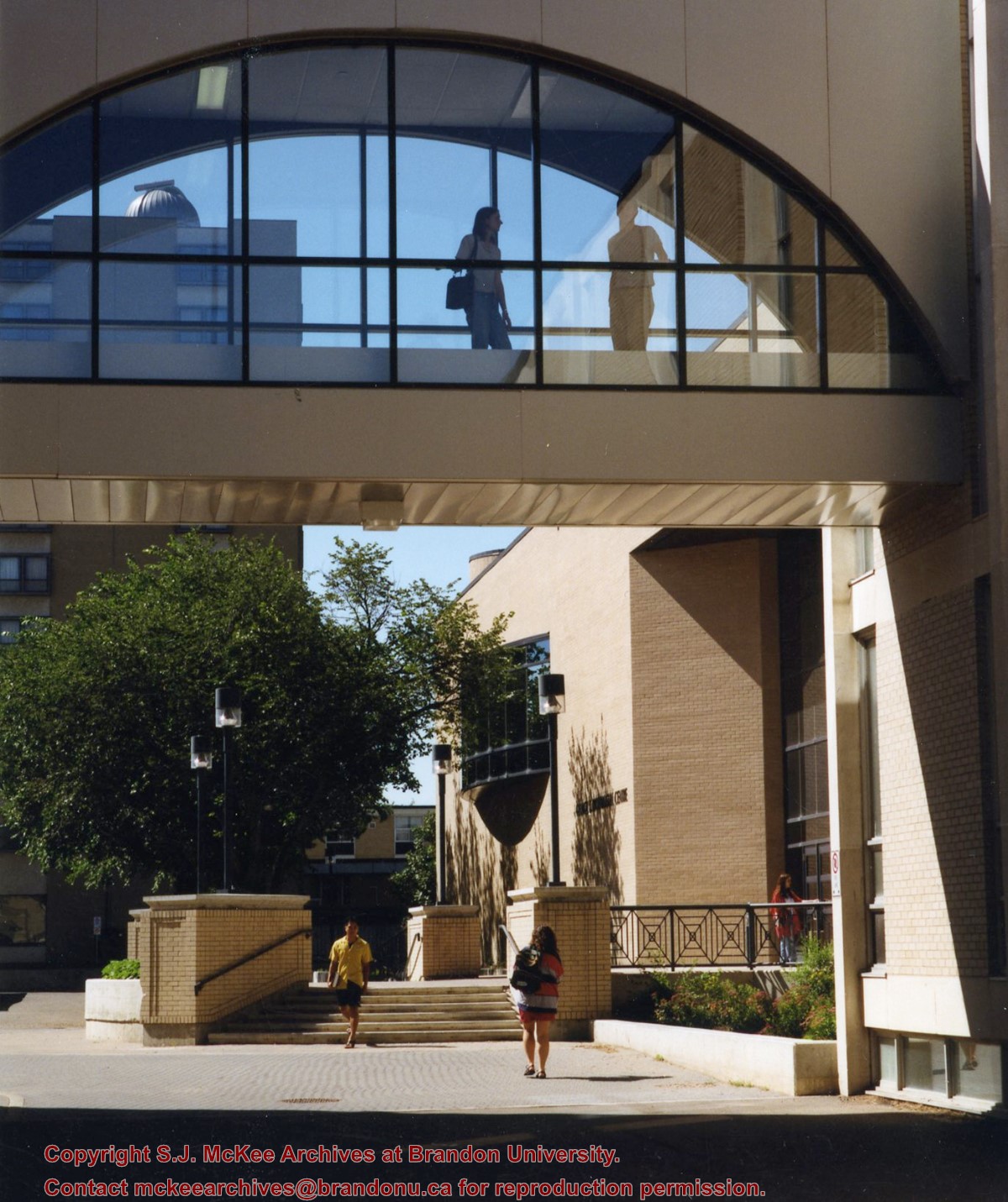
View is south from appromately the skywalk. Photograph shows the walkway that runs in front of the A.E. McKenzie Building south to the George T. Richardson Centre staircase and entrance. McMaster Hall in the background.
Images
Show Less

Brandon University campus

http://archives.brandonu.ca/en/permalink/descriptions8034
Part Of
Aerial views and campus photographs
Description Level
Item
GMD
graphic
Date Range
c. 2000
Part Of
Aerial views and campus photographs
Creator
Photograph: Sandy Black
Description Level
Item
Series Number
2.1
Item Number
2.1.102
GMD
graphic
Date Range
c. 2000
Physical Description
4" x 6" (colour)
Scope and Content
View is north northeast from the roof of the John E. Robbins Library in the George T. Richardson Centre. Photograph shows the entrance to the Richardson Building, part of the courtyard and the Clark Hall extension.
Images
Show Less

Brandon University campus

http://archives.brandonu.ca/en/permalink/descriptions8035
Part Of
Aerial views and campus photographs
Description Level
Item
GMD
graphic
Date Range
c. 2000
Part Of
Aerial views and campus photographs
Creator
Photographer: Sandy Black
Description Level
Item
Series Number
2.1
Item Number
2.1.103
GMD
graphic
Date Range
c. 2000
Physical Description
6" x 4" (colour)
Scope and Content
View is northeast from in front of the John E. Robbins Library in the George T. Richardson Centre. Photograph shows the entrance to the Richardson Building, most of the courtyard, Clark Hall and its extension.
Images
Show Less

Brandon University campus

http://archives.brandonu.ca/en/permalink/descriptions8036
Part Of
Aerial views and campus photographs
Description Level
Item
GMD
graphic
Date Range
c. 2000
Part Of
Aerial views and campus photographs
Creator
Photographer: Sandy Black
Description Level
Item
Series Number
2.1
Item Number
2.1.104
GMD
graphic
Date Range
c. 2000
Physical Description
6" x 4" (colour)
Scope and Content
View is northeast from the roof of the George T. Richardson Centre (John E. Robbins Library). Photograph shows the courtyard and the west side of the Brandon College building and Clark Hall, as well as the Clark Hall extension and part of the skywalk.
Images
Show Less

Brandon University campus

http://archives.brandonu.ca/en/permalink/descriptions8037
Part Of
Aerial views and campus photographs
Description Level
Item
GMD
graphic
Date Range
c. 2000
Part Of
Aerial views and campus photographs
Creator
Photographer: Sandy Black
Description Level
Item
Series Number
2.1
Item Number
2.1.105
GMD
graphic
Date Range
c. 2000
Physical Description
6" x 4" (colour)
Scope and Content
View is east southeast from the roof of the A.E. McKenzie Building. Photograph shows the courtyard and the west side of the Brandon College Building, as well as the Citizens' Science Building and the greenspace in between the two buildings.
Images
Show Less

Brandon University campus

http://archives.brandonu.ca/en/permalink/descriptions8038
Part Of
Aerial views and campus photographs
Description Level
Item
GMD
graphic
Date Range
c. 2000
Part Of
Aerial views and campus photographs
Creator
Photographer: Sandy Black
Description Level
Item
Series Number
2.1
Item Number
2.1.106
GMD
graphic
Date Range
c. 2000
Physical Description
4" x 6" (colour)
Scope and Content
View is from the front steps of the Education Building looking south down the east side of the Brandon College Building and Clark Hall to the Knowles Douglas Students' Union Centre and the John R. Brodie Science Centre in the background.
Images
Show Less

Brandon University campus

http://archives.brandonu.ca/en/permalink/descriptions8039
Part Of
Aerial views and campus photographs
Description Level
Item
GMD
graphic
Date Range
c. 2000
Part Of
Aerial views and campus photographs
Creator
Photographer: Sandy Black
Description Level
Item
Series Number
2.1
Item Number
2.1.107
GMD
graphic
Date Range
c. 2000
Physical Description
4" x 6" (colour)
Scope and Content
Photograph shows the Brandon College Building. It was taken from the sidewalk on 18th Street looking southwest across the front lawn.
Notes
Note on the back of the photograph reads "Please return photo to Sandy."
Images
Show Less

Brandon University campus

http://archives.brandonu.ca/en/permalink/descriptions8040
Part Of
Aerial views and campus photographs
Description Level
Item
GMD
graphic
Date Range
c. 2000
Part Of
Aerial views and campus photographs
Creator
Photographer: Sandy Black
Description Level
Item
Series Number
2.1
Item Number
2.1.108
GMD
graphic
Date Range
c. 2000
Physical Description
4" x 5" (colour)
Scope and Content
View is south. Photograph shows the skywalk and the steps leading to the entrance of the George T. Richardson Centre.
Images
Show Less

Brandon University campus

http://archives.brandonu.ca/en/permalink/descriptions8041
Part Of
Aerial views and campus photographs
Description Level
Item
GMD
graphic
Date Range
c. 1988
Part Of
Aerial views and campus photographs
Description Level
Item
Series Number
2.1
Item Number
2.1.110
GMD
graphic
Date Range
c. 1988
Physical Description
5" x 4" (colour)
Scope and Content
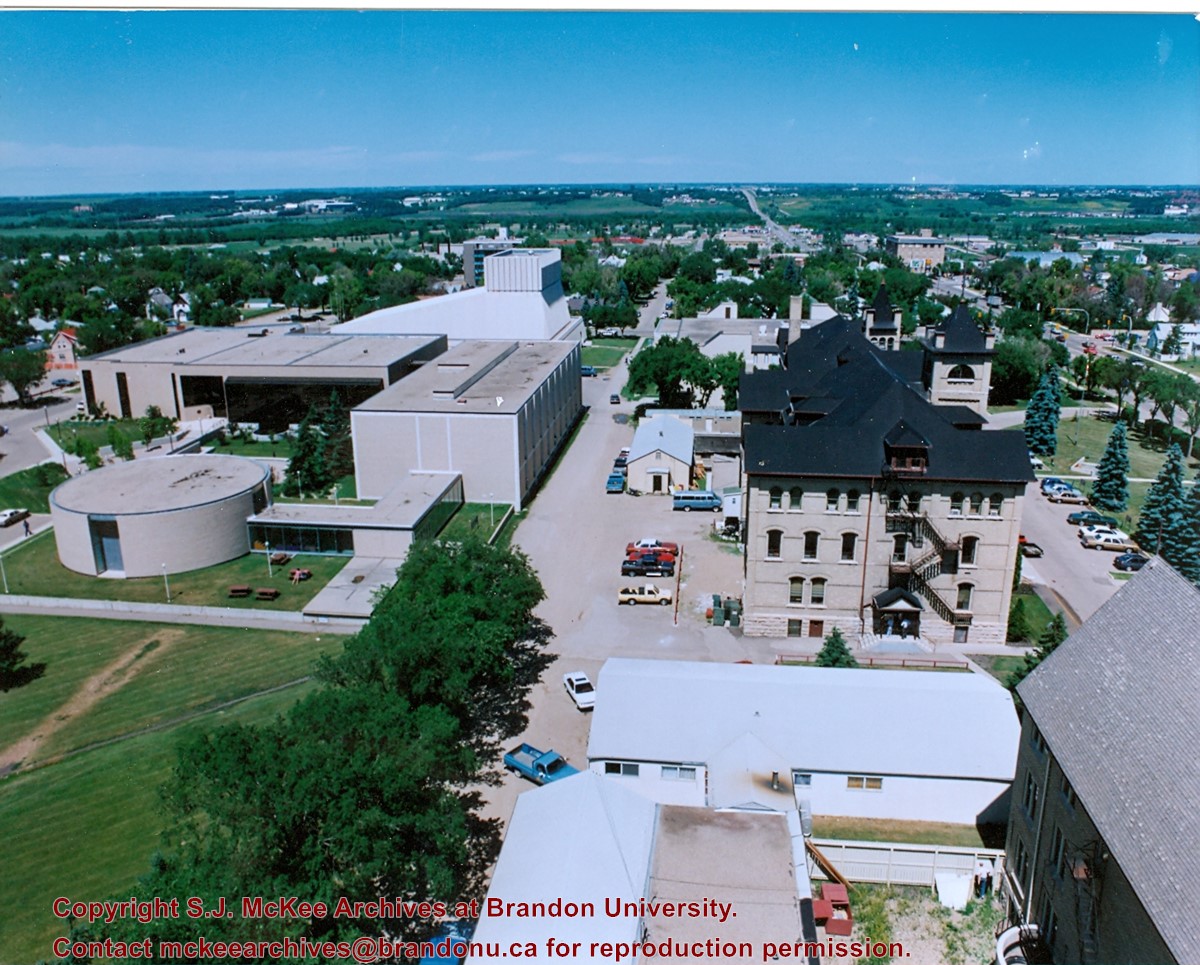
View is north northwest from the roof of McMaster Hall. Photograph shows part of the Citizens' Science Building, a number of H-Huts, the Brandon College Building, the greenspace, the J.R.C. Evans Lecture Theatre, the A.E. McKenzie Building, the Queen Elizabeth II Music Building and the Western Manitoba Centennial Auditorium. A number of residential blocks are also visible.
Images
Show Less

20 records – page 1 of 1.