Skip header and navigation

Revise Search

1917 records – page 1 of 96.

Part Of
RG 11 Lawrence Stuckey fonds
Description Level
Item
GMD
graphic
Date Range
[19--]
Accession Number
1-2002
Part Of
RG 11 Lawrence Stuckey fonds
Description Level
Item
Series Number
3.9
Item Number
1-2002.3.9.175
Accession Number
1-2002
GMD
graphic
Date Range
[19--]
Physical Description
7" x 5" (b/w)
Material Details
Reproduction print
History / Biographical
For History/Bio information see the entry for Gregory's Mill on the Manitoba Historical Society website: http://www.mhs.mb.ca/docs/sites/gregorysmill.shtml
Scope and Content
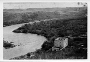
Aerial photograph of Gregory's Mill.
Repro Restriction
The McKee Archives is the copyright holder for the Stuckey materials.
Storage Location
RG 5 photograph storage drawer
Images
Show Less

John R. Brodie Science Centre flower beds

http://archives.brandonu.ca/en/permalink/descriptions3019
Part Of
Brandon University Photograph collection
Description Level
Item
GMD
graphic
Date Range
May 1978
Part Of
Brandon University Photograph collection
Description Level
Item
Series Number
2.1
Item Number
BUPC 2.1.40
GMD
graphic
Date Range
May 1978
Physical Description
5" x 3.5"
Scope and Content
Photograph shows a number of the flower beds located on the north side of the John R. Brodie Science Centre.
Subject Access
campus photographs
Show Less
Part Of
Brandon University Photograph collection
Description Level
Item
GMD
graphic
Date Range
May 1978
Part Of
Brandon University Photograph collection
Description Level
Item
Series Number
2.1
Item Number
BUPC 2.1.41
GMD
graphic
Date Range
May 1978
Physical Description
5" x 3.5" (colour)
Scope and Content
Photograph shows a sign bearing a campus map. The sign was located at the north entrance to the driveway.
Subject Access
campus photographs
Images
Show Less

John R. Brodie Science Centre flower beds

http://archives.brandonu.ca/en/permalink/descriptions3026
Part Of
Brandon University Photograph collection
Description Level
Item
GMD
graphic
Date Range
May 1978
Part Of
Brandon University Photograph collection
Description Level
Item
Series Number
2.1
Item Number
BUPC 2.1.42
GMD
graphic
Date Range
May 1978
Physical Description
5" x 3.5" (colour)
Scope and Content
Photograph shows a number of flower beds located on the north side of the John R. Brodie Science Centre.
Subject Access
campus photographs
Images
Show Less

Lawrence Stuckey photograph collection

http://archives.brandonu.ca/en/permalink/descriptions4796
Part Of
RG 11 Lawrence Stuckey fonds
Description Level
Series
GMD
graphic
Date Range
ca. 1885 to 1991; predominantly 1960-1991
Accession Number
1-2002
Part Of
RG 11 Lawrence Stuckey fonds
Description Level
Series
Series Number
3
Accession Number
1-2002
GMD
graphic
Date Range
ca. 1885 to 1991; predominantly 1960-1991
Physical Description
c. 2700 photograph negatives; c. 100 b/w prints
History / Biographical
For history/bio information see the fonds level description of the Lawrence Stuckey collection.
Custodial History
The entire collection was housed in Mr. Stuckey's residence at 658 11th St. Brandon, Manitoba, prior to its transfer to the McKee Archives. The balance of the materials, including the photograph negative collection, was deposited in the Archives following Mr. Stuckey's death. Some of the negatives came into Mr. Stuckey's possession when he acquired the Clark J. Smith Studio, Brandon, Man.
Scope and Content
Created by Lawrence A. Stuckey, the collection includes some of his own photography. Stuckey took many of the photos during his travels in Southwestern Manitoba and further afield. As well, he acquired copies of negatives that fit his interest from friends, contemporaries, and other professional photographers. The majority of these copies are of photographs that predate Stuckey's era. The collection includes various subjects from Brandon’s history (including people, buildings, transportation, railways, and institutions) 1879 to 1992; surrounding communities, railway lines and trains 1925 to 1989; agriculture ca. 1890 to 1983; railway photographs including the Prairie Dog Central, grain cars and various railways, including Canadian Pacific, Canadian National, Great Northern, and Brandon, Saskatchewan & Hudson's Bay, ca. 1900 to 1992; vehicles, planes, and ships ca. 1940 to 1981; personal photographs including friends, travel and other personal interests. The series has been divided into nine sub-series, including: (1) Brandon history; (2) Westbran project parks; (3) Rural archives; (4) History - miscellaneous (including Walker collection); (5) Grain cars; (6) The prairie dog; (7) Personal interests; (8) Lawrence Stuckey; and (9) Unsorted.
Notes
Funding for series three level descriptions and digitizing of the Lawrence Stuckey fonds has been provided courtesy of a generous grant from the Heritage Grants Advisory Council of the Manitoba Government 2009.
Repro Restriction
The McKee Archives is the copyright holder for the Stuckey materials.
Finding Aid
A copy of the photograph inventory is in the blue binder on the reference shelf in the reading room.
Storage Location
Lawrence Stuckey collection
Arrangement
Subseries 1 - Brandon History A. People B. Bridges C. Streets D. Buildings E. Business F. Fire Dept. G. Hospitals H. Industries I. Streetcars J. Utilities K. Construction L. Transportation (other than rail) M. Exhibition N. Misc. History O. Environs P. Railroads Subseries 2 - Westbran Project Parks Subseries 3 - Rural Archives 1. CPR -North branches -Broadview Sub. (Brandon-Broadview) -CPR lines south of mainline -Carberry Sub. (Winnipeg-Brandon) -Minnedosa & Bredenbury Sub's (Ex. Man. & N.W. Ry.) (Portage la Prairie-Minnedosa-Bredenbury) 2. CNR -Mainline, Rivers Sub. (Winnipeg-Melville) -Gladstone Sub. (Portage-Neepawa) -Wawanesa Sub. (Brandon [M&B Jct]-Belmont) -Rapid City Sub. (Hallboro-Beulah) -Rossburn Sub. (Neepawa-Russell) 3. Surrounding Communities -Brandon NW -Brandon NE -Brandon SW -Brandon SE 4. Agriculture (Steam) 5. Agriculture (Horse & Misc) 6. Agriculture (Miscellaneous) Subseries 4 - History - Miscellaneous (inc. Walker Collection) Subseries 5 - Grain Cars Subseries 6 - The Prairie Dog Subseries 7 - Personal Interests Subseries 8 - Lawrence Stuckey -Friends & Personal 1975- -Travel -Cars & Planes -Ships -Ships & Boats -Great Lakes Seaway -Ships & Canal, Duluth, Minn. Sept. 1980 -Windsor & Toronto 1980, 1981 -Welland Canal 1981
Show Less

Aerial view - Brandon University campus

http://archives.brandonu.ca/en/permalink/descriptions7989
Part Of
Brandon University Photograph collection
Description Level
Item
GMD
graphic
Date Range
c. 2000
Part Of
Brandon University Photograph collection
Creator
Photograph commissioned by Brandon University and taken by Yourview Aerial Scenics Ltd.
Description Level
Item
Series Number
2.1
Item Number
BUPC 2.1.55
GMD
graphic
Date Range
c. 2000
Physical Description
6" x 4" (colour)
Scope and Content
View is southwest from approximatley 16th Street between Princess and Rosser Avenues. Photograph shows the Brandon University campus, as well as surrounding residential blocks, including Flemming, J.R. Reid and Vincent Massey schools.
Subject Access
aerial photographs
campus photographs
campus buildings
Brandon streets
Images
Show Less

Aerial view - Brandon University campus

http://archives.brandonu.ca/en/permalink/descriptions7990
Part Of
Brandon University Photograph collection
Description Level
Item
GMD
graphic
Date Range
c. 2000
Part Of
Brandon University Photograph collection
Creator
Photograph commissioned by Brandon University and taken by Yourview Aerial Scenics Ltd.
Description Level
Item
Series Number
2.1
Item Number
BUPC 2.1.56
GMD
graphic
Date Range
c. 2000
Physical Description
6" x 4" (colour)
Scope and Content
View is west southwest from approximatley 16th Street between Princess and Lorne Avenues. Photograph shows the Brandon University campus, as well as surrounding residential blocks between 16th and 23rd Streets, Princess and Louise Avenues..
Subject Access
aerial photographs
campus photographs
campus buildings
Brandon streets
Images
Show Less

Aerial view - Brandon University campus

http://archives.brandonu.ca/en/permalink/descriptions7991
Part Of
Brandon University Photograph collection
Description Level
Item
GMD
graphic
Date Range
c. 2000
Part Of
Brandon University Photograph collection
Creator
Photograph commissioned by Brandon University and taken by Yourview Aerial Scenics Ltd.
Description Level
Item
Series Number
2.1
Item Number
BUPC 2.1.57
GMD
graphic
Date Range
c. 2000
Physical Description
6" x 4" (colour)
Scope and Content
View is west from approximatley 17th Street between Lorne and Louise Avenues. Photograph shows a portion of the Brandon University campus (excluding the Education Building and anything north of it), as well as surrounding residential blocks from approximatley 17th Street to 22nd Street.
Subject Access
aerial photographs
campus photographs
campus buildings
Brandon streets
Images
Show Less

Aerial view - Brandon University campus

http://archives.brandonu.ca/en/permalink/descriptions7992
Part Of
Brandon University Photograph collection
Description Level
Item
GMD
graphic
Date Range
c. 1990
Part Of
Brandon University Photograph collection
Description Level
Item
Series Number
2.1
Item Number
BUPC 2.1.58
GMD
graphic
Date Range
c. 1990
Physical Description
5" x 3.5" (colour)
Scope and Content
View is west northwest from approximatley 16th Street and Louise Avenue. Photograph shows the Brandon University campus, prior to the Library Extension, and a large portion of the city to the west of the campus.
Subject Access
aerial photographs
campus photographs
campus buildings
Brandon streets
Images
Show Less

Aerial view - Brandon University campus

http://archives.brandonu.ca/en/permalink/descriptions7993
Part Of
Brandon University Photograph collection
Description Level
Item
GMD
graphic
Date Range
c. 1990
Part Of
Brandon University Photograph collection
Description Level
Item
Series Number
2.1
Item Number
BUPC 2.1.59
GMD
graphic
Date Range
c. 1990
Physical Description
5" x 3.5" (colour)
Scope and Content
View is northwest from approximatley 16th Street and Louise Avenue. Photograph shows the Brandon University campus, prior to the Library Extension, and a large portion of the city to the west of the campus.
Subject Access
aerial photographs
campus photographs
campus buildings
Brandon streets
Show Less
Part Of
Brandon University Photograph collection
Description Level
Item
GMD
graphic
Date Range
c. 1985
Part Of
Brandon University Photograph collection
Description Level
Item
Series Number
2.1
Item Number
BUPC 2.1.60
GMD
graphic
Date Range
c. 1985
Physical Description
5" x 3.5" (colour)
Scope and Content
Photograph shows the removal of one of the houses formerly located on 20th Street between Louise and Princess Avenues. The houses on those blocks were removed to create parking lots for the University. A Fed Zavislak Ltd. Well Drilling & Trucking pickup truck is visible at the curb.
Subject Access
campus photographs
Brandon streets
Images
Show Less
Part Of
Brandon University Photograph collection
Description Level
Item
GMD
graphic
Date Range
c. 1985
Part Of
Brandon University Photograph collection
Description Level
Item
Series Number
2.1
Item Number
BUPC 2.1.61
GMD
graphic
Date Range
c. 1985
Physical Description
5" x 3.5" (colour)
Scope and Content
Photograph shows the removal of one of the houses formerly located on 20th Street between Louise and Princess Avenues. The houses on those blocks were removed to create parking lots for the University.
Subject Access
campus photographs
Brandon streets
Images
Show Less
Part Of
Brandon University Photograph collection
Description Level
Item
GMD
graphic
Date Range
May 12, 1992
Part Of
Brandon University Photograph collection
Description Level
Item
Series Number
2.1
Item Number
BUPC 2.1.62
GMD
graphic
Date Range
May 12, 1992
Physical Description
5.75" x 3.75" (colour)
Scope and Content
Photograph shows a backhoe digging a sewer hole near the sidewalk between the Brandon College Building and the Citizens' Science Building. The Knowles-Douglas Students' Union Centre, John R. Brodie Science Centre and a portion of the driveway are visible in the background.
Subject Access
campus photographs
campus buildings
campus construction
Images
Show Less

Brandon University campus

http://archives.brandonu.ca/en/permalink/descriptions7997
Part Of
Brandon University Photograph collection
Description Level
Item
GMD
graphic
Date Range
c. 1996
Part Of
Brandon University Photograph collection
Creator
Photographer: Sandy Black
Description Level
Item
Series Number
2.1
Item Number
BUPC 2.1.63
GMD
graphic
Date Range
c. 1996
Physical Description
6" x 4" (colour)
Scope and Content
View is northwest from the roof of the John R. Brodie Science Centre. Photograph shows the roof of the Knowles Douglas Students' Union Centre, the Citizens' Science Building, and the Brandon College Building and Clark Hall during renovation.
Subject Access
campus photographs
campus buildings
campus construction
Images
Show Less

Brandon University campus

http://archives.brandonu.ca/en/permalink/descriptions7998
Part Of
Brandon University Photograph collection
Description Level
Item
GMD
graphic
Date Range
c. 1993
Part Of
Brandon University Photograph collection
Description Level
Item
Series Number
2.1
Item Number
BUPC 2.1.64
GMD
graphic
Date Range
c. 1993
Physical Description
6" x 4" (colour)
Scope and Content
Photograph was taken from the roof of the Library and shows the walkway and flower bed on the southeast corner of the George T. Richardson Centre. The Physical Plant H-Hut is visible in the top right hand corner.
Subject Access
campus photographs
Images
Show Less

Brandon University campus

http://archives.brandonu.ca/en/permalink/descriptions7999
Part Of
Brandon University Photograph collection
Description Level
Item
GMD
graphic
Date Range
c. 1993
Part Of
Brandon University Photograph collection
Description Level
Item
Series Number
2.1
Item Number
BUPC 2.1.65
GMD
graphic
Date Range
c. 1993
Physical Description
4" x 6" (colour)
Scope and Content
View is southwest from the roof of the George T. Richardson Centre. Photograph shows the curved glass wall of the John E. Robbins Library, the walkway between the Library and the Dining Hall, the Dining Hall and Darrach Hall.
Subject Access
campus photographs
campus buildings
Images
Show Less

Brandon University campus construction

http://archives.brandonu.ca/en/permalink/descriptions8000
Part Of
Brandon University Photograph collection
Description Level
Item
GMD
graphic
Date Range
c. 1996
Part Of
Brandon University Photograph collection
Creator
Photographer: Sandy Black
Description Level
Item
Series Number
2.1
Item Number
BUPC 2.1.66
GMD
graphic
Date Range
c. 1996
Physical Description
6" x 4" (colour)
Scope and Content
View is southeast from the roof of the A.E. McKenzie Building. Photograph shows the construction of the extension of Clark Hall and the skywalk.
Subject Access
campus photographs
campus buildings
campus construction
Images
Show Less

Brandon University campus construction

http://archives.brandonu.ca/en/permalink/descriptions8001
Part Of
Brandon University Photograph collection
Description Level
Item
GMD
graphic
Date Range
c. 1996
Part Of
Brandon University Photograph collection
Creator
Photographer: Sandy Black
Description Level
Item
Series Number
2.1
Item Number
BUPC 2.1.67
GMD
graphic
Date Range
c. 1996
Physical Description
6" x 4" (colour)
Scope and Content
View is north probably from the roof of McMaster Hall. Photograph shows the construction of the extension of Clark Hall and the skywalk.
Subject Access
campus photographs
campus buildings
campus construction
Images
Show Less

Brandon University campus construction

http://archives.brandonu.ca/en/permalink/descriptions8002
Part Of
Brandon University Photograph collection
Description Level
Item
GMD
graphic
Date Range
c. 1996
Part Of
Brandon University Photograph collection
Creator
Photographer: Sandy Black
Description Level
Item
Series Number
2.1
Item Number
BUPC 2.1.68
GMD
graphic
Date Range
c. 1996
Physical Description
6" x 4" (colour)
Scope and Content
View is north probably from the roof of McMaster Hall. Photograph shows the construction of the new roof on Clark Hall and the Brandon College Building.
Subject Access
campus photographs
campus buildings
campus construction
Images
Show Less

Brandon University campus construction

http://archives.brandonu.ca/en/permalink/descriptions8003
Part Of
Brandon University Photograph collection
Description Level
Item
GMD
graphic
Date Range
c. 1996
Part Of
Brandon University Photograph collection
Description Level
Item
Series Number
2.1
Item Number
2.1.69
GMD
graphic
Date Range
c. 1996
Physical Description
6" x 4" (colour)
Scope and Content
View is southwest from Clark Hall. Photograph shows the construction of the extension of Clark Hall.
Subject Access
campus photographs
campus buildings
campus construction
Images
Show Less

1917 records – page 1 of 96.