Skip header and navigation

Revise Search

20 records – page 1 of 1.

100-block 10th Street, facing west (3)

http://archives.brandonu.ca/en/permalink/descriptions8408
Part Of
Joseph H. Hughes collection
Description Level
Item
GMD
graphic
Date Range
c. 1955
Accession Number
3-1997
Part Of
Joseph H. Hughes collection
Creator
Photographer: R.M. Coleman
Description Level
Item
Series Number
3-1997.1
Item Number
3-1997.1.30
Accession Number
3-1997
GMD
graphic
Date Range
c. 1955
Physical Description
8 " x 5" (b/w)
Physical Condition
good
Scope and Content
Photograph shows the west side of 10th Street between Rosser and Princess Avenues in the winter. Visible businesses include: Bottomley's, Simpsons-Sears, Lionel Electric, Allied Hardware Stores, Box Brothers Hardware, Doig's. Painted on the north face of the Strathcona Block are two advertisements, one for Sutherland and Robertson [Grocery] and the other for Boyd Electric Co. Ltd.
Name Access
10th Street
Bottomley's
Simpsons-Sears Ltd.
Lionel Electric
Sutherland and Robertson
Boyd Electric Co. Ltd.
Strathcona Block
Box Brothers Hardware
Doig's
Allied Hardware
Alexandra Block
Subject Access
downtowns
street scenes
Brandon business buildings & facilities after 1940
building exteriors
winter
Storage Location
RG 5 photograph storage drawer
Images
Show Less

Rosser Avenue between 7th and 8th Streets, south side, Brandon, Manitoba

http://archives.brandonu.ca/en/permalink/descriptions8421
Part Of
Joseph H. Hughes collection
Description Level
Item
GMD
graphic
Date Range
c.1960s
Accession Number
3-1997
Part Of
Joseph H. Hughes collection
Creator
Photographer: R.M. Coleman
Description Level
Item
Series Number
3-1997.1
Item Number
3-1997.1.43
Accession Number
3-1997
GMD
graphic
Date Range
c.1960s
Physical Description
8" x 5" (b/w)
Physical Condition
good
History / Biographical
The Royal Bank moved to this location on 26 October 1929. An existing building was renovated to accomodate the bank. On 28 May 1976 fire destroyed the buildings from the lane west to the Royal Bank.
Scope and Content
Photograph shows the south side of Rosser Avenue between 7th and 8th Streets, west of the Eaton's building. Visible shops include: Vogue [Ladies Wear], Smith's Drugs, Sobie's Tailored Undergarnments, Household Finance Loans, and The Royal Bank of Canada.
Name Access
Vogue Ladies Wear
Smith's Drugs
Sobie's
Household Finance Loans
Royal Bank of Canada
Subject Access
downtowns
street scenes
Brandon business buildings & facilities after 1940
building exteriors
winter
Storage Location
RG 5 photograph storage drawer
Images
Show Less

Western Motors at southwest corner 10th and Princess Avenue, Brandon, Manitoba

http://archives.brandonu.ca/en/permalink/descriptions8415
Part Of
Joseph H. Hughes collection
Description Level
Item
GMD
graphic
Date Range
c.1955
Accession Number
3-1997
Part Of
Joseph H. Hughes collection
Description Level
Item
Series Number
3-1997.1
Item Number
3-1997.1.37
Accession Number
3-1997
GMD
graphic
Date Range
c.1955
Physical Description
10" x 8" (b/w)
Physical Condition
good
Scope and Content
Photograph shows Western Motors Ltd. on the southwest corner of 10th Street and Princess Avenue. To the west of the car dealership/garage is the Greyhound Bus Station and its Maxwell House Cafe as well as the court house.
Name Access
Greyhound
Western Motors Ltd.
Princess Avenue
Maxwell House Grill
Court House
Subject Access
downtowns
street scenes
Brandon business buildings & facilities after 1940
building exteriors
winter
bus depots
garages
Storage Location
RG 5 photograph storage drawer
Images
Show Less

West side 200-block 10th Street, south of Princess Avenue, Brandon, Manitoba

http://archives.brandonu.ca/en/permalink/descriptions8416
Part Of
Joseph H. Hughes collection
Description Level
Item
GMD
graphic
Date Range
c. 1955
Accession Number
3-1997
Part Of
Joseph H. Hughes collection
Description Level
Item
Series Number
3-1997.1
Item Number
3-1997.1.38
Accession Number
3-1997
GMD
graphic
Date Range
c. 1955
Physical Description
10" x 8" (b/w)
Physical Condition
good
Scope and Content
Photograph shows the west side of the 200-block on 10th Street. Visible businesses include: Chamber of Commerce Tourist Information, Dominion Tire & Radio Co., Bonnie's Bonnet Shop, Steve's Grill, Wally's Taxi, and Western Motors Ltd. The painted advertisement for Doig, Rankin and Robertson is visible on the Alexandra Block. Christmas ornaments are displayed from light standards and include Santa Claus and a Christmas elf.
Name Access
Chamber of Commerce
Dominion Tire & Radio Co.
Bonnie's Bonnet Shop
Steve's Grill
Wally's Taxi
Western Motors
10th Street
Subject Access
downtowns
street scenes
Brandon business buildings & facilities after 1940
building exteriors
winter
garages
taxi
restaurants
Christmas
Storage Location
RG 5 photograph storage drawer
Images
Show Less

West side 200-block 10th Street facing south from Princess Avenue, Brandon, Manitoba

http://archives.brandonu.ca/en/permalink/descriptions8417
Part Of
Joseph H. Hughes collection
Description Level
Item
GMD
graphic
Date Range
c.1955
Accession Number
3-1997
Part Of
Joseph H. Hughes collection
Description Level
Item
Series Number
3-1997.1
Item Number
3-1997.1.39
Accession Number
3-1997
GMD
graphic
Date Range
c.1955
Physical Description
10" x 8" (b/w)
Physical Condition
good
Scope and Content
Photograph shows the west side of the 200-block on 10th Street. Visible businesses include: Chamber of Commerce Tourist Information, Dominion Tire & Radio Co., Steve's Grill, Wally's Taxi, and the garage entrances to Western Motors Ltd. A Santa Claus Christmas ornament is displayed from a light standard.
Name Access
Chamber of Commerce
Dominion Tire & Radio Co.
Steve's Grill
Wally's Taxi
Western Motors
10th Street
Subject Access
downtowns
street scenes
Brandon business buildings & facilities after 1940
building exteriors
winter
garages
taxi
restaurants
Christmas
Storage Location
RG 5 photograph storage drawer
Images
Show Less

Brandon University campus construction

http://archives.brandonu.ca/en/permalink/descriptions8011
Part Of
Brandon University Photograph collection
Description Level
Item
GMD
graphic
Date Range
c. 1996
Part Of
Brandon University Photograph collection
Description Level
Item
Series Number
2.1
Item Number
BUPC 2.1.77
GMD
graphic
Date Range
c. 1996
Physical Description
6" x 4" (colour)
Scope and Content
View is northwest from Clark Hall. Photograph shows construction materials in the area between Clark Hall and the A.E. McKenzie Building during winter. The Western Manitoba Centennial Auditorium is visible in the upper right hand corner.
Subject Access
campus photographs
campus buildings
campus construction
winter
Images
Show Less

Brandon University campus construction

http://archives.brandonu.ca/en/permalink/descriptions8012
Part Of
Brandon University Photograph collection
Description Level
Item
GMD
graphic
Date Range
c. 1996
Part Of
Brandon University Photograph collection
Description Level
Item
Series Number
2.1
Item Number
BUPC 2.1.78
GMD
graphic
Date Range
c. 1996
Physical Description
6" x 4" (colour)
Scope and Content
View is south southeast from the skywalk. Photograph shows the courtyard in winter full of vehicles, machines and building materials. Also visible are the Development and Physical Plant H-Huts, the Citizens' Science Building, the John R. Brodie Science Centre and McMaster Hall.
Subject Access
campus photographs
campus buildings
campus construction
winter
Images
Show Less

Brandon University campus construction

http://archives.brandonu.ca/en/permalink/descriptions8014
Part Of
Brandon University Photograph collection
Description Level
Item
GMD
graphic
Date Range
c. 1996
Part Of
Brandon University Photograph collection
Description Level
Item
Series Number
2.1
Item Number
BUPC 2.1.80
GMD
graphic
Date Range
c. 1996
Physical Description
6" x 4" (colour)
Scope and Content
View is northwest from the roof of the Brandon College Building. Photograph was taken through wire fencing and shows construction on the roof of the Brandon College Building during winter. The original Clark Hall entrance to the roof is clearly visible. Portions of the A.E. McKenzie Building, Clark Hall and the Western Manitoba Centennial Auditorium are visible in the background.
Subject Access
campus photographs
campus buildings
campus construction
winter
Images
Show Less

Brandon University campus construction

http://archives.brandonu.ca/en/permalink/descriptions8021
Part Of
Brandon University Photograph collection
Description Level
Item
GMD
graphic
Date Range
c. 1996
Part Of
Brandon University Photograph collection
Description Level
Item
Series Number
2.1
Item Number
BUPC 2.1.87
GMD
graphic
Date Range
c. 1996
Physical Description
6" x 4" (colour)
Scope and Content
Photograph was taken from the skywalk and shows students leaving the George T. Richardson Centre during winter. The courtyard contains construction materials. The Physical Plant H-Hut and McMaster Hall are partially visible in the background.
Subject Access
campus photographs
campus buildings
campus construction
winter
Images
Show Less

First of several CNR trains of lumber for Hughes & Co.

http://archives.brandonu.ca/en/permalink/descriptions14245
Part Of
Joseph H. Hughes collection
Description Level
Item
GMD
graphic
Date Range
c.1900
Accession Number
3-1997
Part Of
Joseph H. Hughes collection
Description Level
Item
Series Number
3-1997.1
Item Number
3-1997.1.54
Accession Number
3-1997
Other Numbers
Hughes #55
GMD
graphic
Date Range
c.1900
Physical Description
7.25" x 5.75" (b/w)
Material Details
on matting
Physical Condition
water marks on matting, holes in corners
Scope and Content
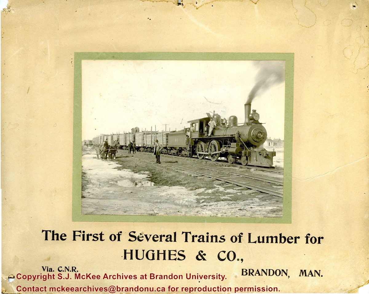
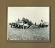
Photograph shows CNR train No.44 carrying loads of lumber. Engineers pose with the locomotive. Several men pose on the railway tracks. Snow and ice appear in the ditch.
Notes
Writing on the front of the photograph reads: The First of Several Trains of Lumber for HUGHES & CO., Via C.N.R., Brandon, Man. Photograph is stamped on the back: Huhges & Co. Ltd., 1009 Princess Ave., Brandon, Man.
Name Access
Hughes & Co.
Canadian National Railway
Subject Access
trains
lumber
lumbering
lumber manufacturing
winter
Transportation
Storage Location
Hughes oversize drawer
Images
Show Less
Part Of
Joseph H. Hughes collection
Description Level
Item
GMD
graphic
Date Range
[1906-1910]
Accession Number
3-1997
Part Of
Joseph H. Hughes collection
Creator
Photographer: Martel's, Brandon
Description Level
Item
Series Number
3-1997.1
Item Number
3-1997.1.57
Accession Number
3-1997
Other Numbers
Hughes #58
GMD
graphic
Date Range
[1906-1910]
Physical Description
9.5" x 7.5" (b/w)
Material Details
on matting
Scope and Content
Photograph shows two wooden grain silos on a farm property. One silo appears to be recently constructed.
Notes
Photograph dated based on period Martel's operated in Brandon.
Name Access
Hughes & Co.
Subject Access
harvesting
farms
Grain Storage
Storage Location
Hughes oversize drawer
Images
Show Less
Part Of
Joseph H. Hughes collection
Description Level
Item
GMD
graphic
Date Range
[1912-1914]
Accession Number
3-1997
Part Of
Joseph H. Hughes collection
Creator
Photographer: Boynton & Eaton, Reston
Description Level
Item
Series Number
3-1997.1
Item Number
3-1997.1.73
Accession Number
3-1997
Other Numbers
Hughes #72
GMD
graphic
Date Range
[1912-1914]
Physical Description
9.5" x 7.5" (b/w)
Material Details
on matting
Physical Condition
Photograph is stained
Scope and Content
Photograph shows four horse teams with four men, posing with wood-framed wagons as they are being loaded with hay from the field.
Notes
Manitoba Historical Society places Boyton & Eaton in Reston from 1912-1914
Subject Access
harvesting
threshing crews
Agriculture
Storage Location
Hughes oversize drawer
Images
Show Less
Part Of
Brandon University Photograph collection
Description Level
Item
GMD
graphic
Date Range
c. 1985
Part Of
Brandon University Photograph collection
Description Level
Item
Series Number
2.1
Item Number
BUPC 2.1.60
GMD
graphic
Date Range
c. 1985
Physical Description
5" x 3.5" (colour)
Scope and Content
Photograph shows the removal of one of the houses formerly located on 20th Street between Louise and Princess Avenues. The houses on those blocks were removed to create parking lots for the University. A Fed Zavislak Ltd. Well Drilling & Trucking pickup truck is visible at the curb.
Subject Access
campus photographs
Brandon streets
Images
Show Less
Part Of
Brandon University Photograph collection
Description Level
Item
GMD
graphic
Date Range
c. 1985
Part Of
Brandon University Photograph collection
Description Level
Item
Series Number
2.1
Item Number
BUPC 2.1.61
GMD
graphic
Date Range
c. 1985
Physical Description
5" x 3.5" (colour)
Scope and Content
Photograph shows the removal of one of the houses formerly located on 20th Street between Louise and Princess Avenues. The houses on those blocks were removed to create parking lots for the University.
Subject Access
campus photographs
Brandon streets
Images
Show Less

Brandon University campus construction

http://archives.brandonu.ca/en/permalink/descriptions8016
Part Of
Brandon University Photograph collection
Description Level
Item
GMD
graphic
Date Range
c. 1996
Part Of
Brandon University Photograph collection
Creator
Photographer: Sandy Black
Description Level
Item
Series Number
2.1
Item Number
BUPC 2.1.82
GMD
graphic
Date Range
c. 1996
Physical Description
4" x 6" (colour)
Scope and Content
View is northeast from the Brandon College Building. Photograph shows the inside of the Brandon College Building after it had been gutted and then partially rebuilt. The exterior fascade of the west side of the building can be clearly seen in this photograph. A number of houses on the east side of 200 block of 18th Street are also visible, as is the stone fence on Princess Avenue and the flag pole on the front lawn.
Subject Access
campus photographs
campus construction
Brandon streets
Images
Show Less

Northeast corner 10th Street and Princess Avenue, Brandon, Manitoba (1)

http://archives.brandonu.ca/en/permalink/descriptions8372
Part Of
Joseph H. Hughes collection
Description Level
Item
GMD
graphic
Date Range
1962
Accession Number
3-1997
Part Of
Joseph H. Hughes collection
Description Level
Item
Series Number
3-1997.1
Item Number
3-1997.1.3
Accession Number
3-1997
GMD
graphic
Date Range
1962
Physical Description
8" x 10" (b/w)
Physical Condition
good
Scope and Content
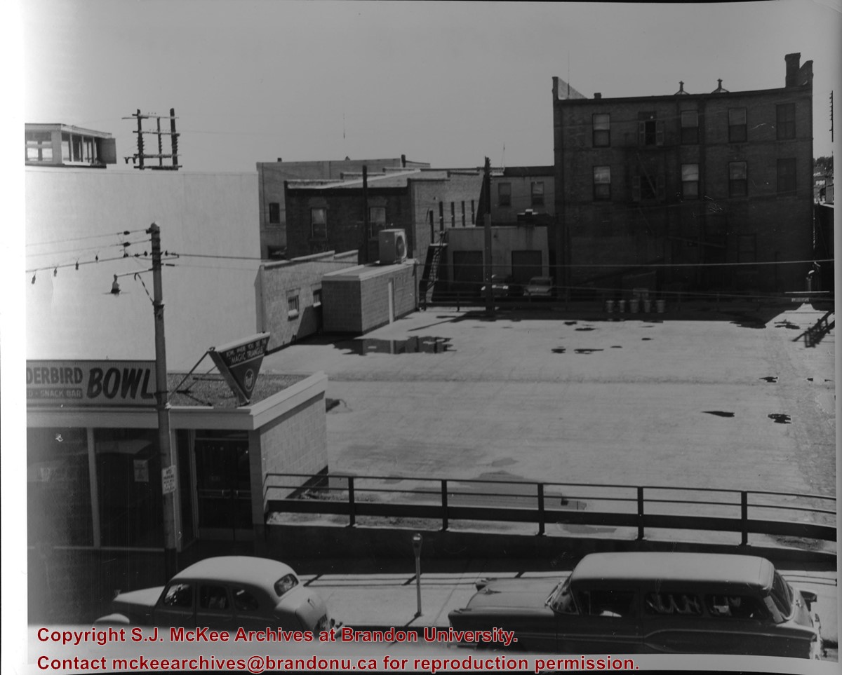
Photograph of an northeast corner 10th Street and Princess Avenue and the rear of buildings facing 200 block on 9th Street. The business in foreground is Thunderbird Bowl. The rear of the Brandon Inn is in the background.
Notes
Photograph dated from "Tara's Bulba," the movie playing at the Strand Theatre and similiar vehicles captured in the photograph.
Name Access
Thunderbird Bowl
10th Street
Subject Access
Brandon business buildings & facilities after 1940
bowling
Storage Location
RG 5 photograph storage drawer
Images
Show Less

Northeast corner 10th Street and Princess Avenue, Brandon, Manitoba (2)

http://archives.brandonu.ca/en/permalink/descriptions8374
Part Of
Joseph H. Hughes collection
Description Level
Item
GMD
graphic
Date Range
1962
Accession Number
3-1997
Part Of
Joseph H. Hughes collection
Description Level
Item
Series Number
3-1997.1
Item Number
3-1997.1.4
Accession Number
3-1997
GMD
graphic
Date Range
1962
Physical Description
8" x 10" (b/w)
Physical Condition
good
Scope and Content
Photograph shows a view of downtown Brandon from the northeast corner of 10th Street and Princess Avenue. Thunderbird Bowl is in the foreground. Painted advertisements on the sides of buildings include: The Mitrou's Cafe and Tea Room and Brandon Musical Supply Ltd. Vehicles parked on 10th Street are facing north.
Notes
Photograph dated from "Tara's Bulba," the movie playing at the Strand Theatre and similiar vehicles captured in the photograph.
Name Access
Thunderbird Bowl
Mitrou Building
Brandon Musical Supply Ltd.
10th Street
Subject Access
downtowns
Brandon business buildings & facilities after 1940
Storage Location
RG 5 photograph storage drawer
Images
Show Less

Aerial view - Brandon University campus

http://archives.brandonu.ca/en/permalink/descriptions7989
Part Of
Brandon University Photograph collection
Description Level
Item
GMD
graphic
Date Range
c. 2000
Part Of
Brandon University Photograph collection
Creator
Photograph commissioned by Brandon University and taken by Yourview Aerial Scenics Ltd.
Description Level
Item
Series Number
2.1
Item Number
BUPC 2.1.55
GMD
graphic
Date Range
c. 2000
Physical Description
6" x 4" (colour)
Scope and Content
View is southwest from approximatley 16th Street between Princess and Rosser Avenues. Photograph shows the Brandon University campus, as well as surrounding residential blocks, including Flemming, J.R. Reid and Vincent Massey schools.
Subject Access
aerial photographs
campus photographs
campus buildings
Brandon streets
Images
Show Less

Aerial view - Brandon University campus

http://archives.brandonu.ca/en/permalink/descriptions7990
Part Of
Brandon University Photograph collection
Description Level
Item
GMD
graphic
Date Range
c. 2000
Part Of
Brandon University Photograph collection
Creator
Photograph commissioned by Brandon University and taken by Yourview Aerial Scenics Ltd.
Description Level
Item
Series Number
2.1
Item Number
BUPC 2.1.56
GMD
graphic
Date Range
c. 2000
Physical Description
6" x 4" (colour)
Scope and Content
View is west southwest from approximatley 16th Street between Princess and Lorne Avenues. Photograph shows the Brandon University campus, as well as surrounding residential blocks between 16th and 23rd Streets, Princess and Louise Avenues..
Subject Access
aerial photographs
campus photographs
campus buildings
Brandon streets
Images
Show Less

Aerial view - Brandon University campus

http://archives.brandonu.ca/en/permalink/descriptions7991
Part Of
Brandon University Photograph collection
Description Level
Item
GMD
graphic
Date Range
c. 2000
Part Of
Brandon University Photograph collection
Creator
Photograph commissioned by Brandon University and taken by Yourview Aerial Scenics Ltd.
Description Level
Item
Series Number
2.1
Item Number
BUPC 2.1.57
GMD
graphic
Date Range
c. 2000
Physical Description
6" x 4" (colour)
Scope and Content
View is west from approximatley 17th Street between Lorne and Louise Avenues. Photograph shows a portion of the Brandon University campus (excluding the Education Building and anything north of it), as well as surrounding residential blocks from approximatley 17th Street to 22nd Street.
Subject Access
aerial photographs
campus photographs
campus buildings
Brandon streets
Images
Show Less

20 records – page 1 of 1.