Skip header and navigation

Revise Search

20 records – page 1 of 1.

Lovstrom Block H - summary

http://archives.brandonu.ca/en/permalink/descriptions12638
Part Of
RG 7 Beverley Nicholson fonds
Description Level
Sub-series
GMD
multiple media
Date Range
1988 - 1991
Accession Number
1-2010
Part Of
RG 7 Beverley Nicholson fonds
Description Level
Sub-series
Series Number
3.9
Accession Number
1-2010
GMD
multiple media
Date Range
1988 - 1991
History / Biographical
The vegetation in block H is similar to other areas in the locale with an open oak forest with a light understory of saskatoon, hazelnut, poison ivy and sarsaparilla. 
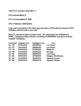
The excavations of the eight 1m2 units in 1988 resulted in the recovery of over 650 ceramic fragments including 20 rim sherds from at least four vessels, a grooved maul, fire-cracked rock, lithic debitage and a reworked Avonlea projectile point. A large amount of bison bone, including a number of axial elements and a fragmented skull were also recovered. Based on the 1988 recoveries at the site further excavations took place in 1991. Nine excavation units were opened next to the previous excavations. Another 250 ceramic sherds were recovered in 1991. Nine vessels have been identified based on rim sherds. Vickers Focus and Woodland vessels have been identified and two vessels similar to Scattered Village Complex were recovered. The lithic material assemblage is intermediate between Blocks G and E with KRF being the most frequent material category followed by local cherts. Two features, a hearth and a curvilinear arrangement of rock were recovered. The high numbers of ceramic fragments suggests a habitation area, rather than hunting or butchering behavior. However, the separation of occupations at the site is difficult to establish and there may be different uses of the site by successive occupations. 
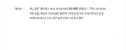
Radiocarbon dates from this block indicate two occupations separated in time by some 300 years. XU 181 – 405/110 BP and XU 184 – 780/110 BP.
Scope and Content
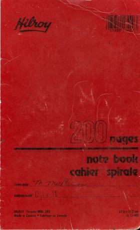
Sub-series has been divided into sub sub series including: Lovstrom Block H 1988 and Lovstrom Block H 1991.
Name Access
Lovstrom Block H - summary
Subject Access
Archaeology Lovstrom locale Lovstrom Block H
Show Less

Lovstrom Block H 1988

http://archives.brandonu.ca/en/permalink/descriptions12639
Part Of
RG 7 Beverley Nicholson fonds
Description Level
Sub sub series
GMD
multiple media
Date Range
1988
Accession Number
1-2010
Part Of
RG 7 Beverley Nicholson fonds
Description Level
Sub sub series
Series Number
3.9.1
Accession Number
1-2010
GMD
multiple media
Date Range
1988
Material Details
Field journals have been scanned in multi-page PDF files. Artifact catalogues are PDF files in spreadsheet format. Photographs are in jpeg format.
History / Biographical
Directed by Dr. Nicholson and with Ian Kuijt as crew chief, eight units were excavated in Block H in 1988. The vegetation is similar to other areas in the locale with an open oak forest with a light understory of saskatoon, hazelnut, poison ivy and sarsaparilla. Radiocarbon dates from this block indicate two occupations separated in time by some 300 years. The excavation of the eight 1m2 units resulted in the recovery of over 650 ceramic fragments including 20 rim sherds from at least four vessels, a grooved maul, fire-cracked rock, lithic debitage and a reworked Avonlea projectile point. A large amount of bison bone, including a number of axial elements and a fragmented skull were also recovered. The 650 ceramics recovered are of two kinds, representing at least four vessels. Stylistically, two of these vessels appear to be from the Vickers Focus and the third vessel may be Mortlach ware. The fourth vessel appears to be Blackduck and probably comes from the lower occupation. Also encountered were what is possibly a thin ash deposit in unit 180. The presence of a large number of bison axial elements is suggestive of primary butchering activities. Several canid bones were recovered scattered among the bison bone. Although there is no visible stratigraphic evidence, the 14C dates and the different ceramic types indicate more than one occupation in this area and it is likely that several types of behavior and use of space are represented. High numbers of ceramic fragments are often assumed to be associated with activities characteristic of habitation areas, rather than hunting or butchering behavior. The lithic material assemblage is intermediate between Blocks G and E with KRF being the most frequent material category followed by local cherts.
Scope and Content
Sub-sub-sub series contains: Summary information of field methology, number and co-ordinates of excavations, personnel and their staff position; Field journals are daily records of recoveries, features and activities at the site; Site records include excavation level and unit summaries, feature sheets, profiles; sample records and maps; Artifact catalogues are lists and identifications of all artifacts recovered; Photographs are of excavation units, features, the landscape and personnel.
Name Access
Lovstrom Block H 1988
Subject Access
Archaeology Lovstrom locale Lovstrom Block H
Show Less

Lovstrom Block H 1988 - site co-ordinates

http://archives.brandonu.ca/en/permalink/descriptions12640
Part Of
RG 7 Beverley Nicholson fonds
Description Level
sub sub sub series
GMD
multiple media
Date Range
1988
Accession Number
1-2010
{add= ARCH 3. Lovstrom Locale DjLx-1 3.9 Lovstrom Block H 3.9.1 Lovstrom Block H 1988
Part Of
RG 7 Beverley Nicholson fonds
Description Level
sub sub sub series
Series Number
3.9.1.1
Accession Number
1-2010
GMD
multiple media
Date Range
1988
Material Details
Field journals have been scanned in multi-page PDF files. Artifact catalogues are PDF files in spreadsheet format. Photographs are in jpeg format.
History / Biographical
Large scale excavations of four block sites took place in 1988 under the direction of Bev Nicholson with Ian Kuijt as crew chief. Block H consisted of eight excavation units.
Scope and Content
Sub-sub-sub series contains: Summary information of field methology, number and co-ordinates of excavations, personnel and their staff position.
Name Access
Lovstrom Block H 1988 - site co-ordinates
Subject Access
Archaeology Lovstrom locale Lovstrom Block H
Documents
Show Less

Lovstrom Block H 1988 - Ian Kuijt field journal 2

http://archives.brandonu.ca/en/permalink/descriptions12641
Part Of
RG 7 Beverley Nicholson fonds
Description Level
File
GMD
textual records
Date Range
1988
Accession Number
1-2010
Part Of
RG 7 Beverley Nicholson fonds
Description Level
File
Series Number
3.9.1.2
File Number
1
Accession Number
1-2010
GMD
textual records
Date Range
1988
Physical Description
35 pp.
Material Details
PDF
History / Biographical
Ian Kuijt was crew chief at the Lovstrom locale excavations in 1988.
Scope and Content
Record of excavation methods, items recovered, features, local environment and weather noted by teaching assistant.
Name Access
Lovstrom Block H 1988 - Ian Kuijt field journal 2
Subject Access
Archaeology Lovstrom locale Lovstrom Block H
Documents

3.9.1.2.1_I_Kuijt_bk2.pdf

Read PDF Download PDF
Show Less

Lovstrom Block H 1988 - L Dueck field journal

http://archives.brandonu.ca/en/permalink/descriptions12642
Part Of
RG 7 Beverley Nicholson fonds
Description Level
File
GMD
textual records
Date Range
1988
Accession Number
1-2010
Part Of
RG 7 Beverley Nicholson fonds
Description Level
File
Series Number
3.9.1.2
File Number
2
Accession Number
1-2010
GMD
textual records
Date Range
1988
Physical Description
64 pp.
Material Details
PDF
History / Biographical
Lori Dueck was a crew member at the Lovstrom locale excavations in 1988. Pages 37-54 and 72-78 in her journal relate to Block H.
Scope and Content
Record of excavation methods, items recovered, features, local environment and weather noted by teaching assistant.
Name Access
Lovstrom Block H 1988 - L Dueck field journal
Subject Access
Archaeology Lovstrom locale Lovstrom Block H
Documents

3.9.1.2.2_L_Dueck.pdf

Read PDF Download PDF
Show Less

Lovstrom Block H 1988 - M MacPherson field journal

http://archives.brandonu.ca/en/permalink/descriptions12643
Part Of
RG 7 Beverley Nicholson fonds
Description Level
File
GMD
textual records
Date Range
1988
Accession Number
1-2010
Part Of
RG 7 Beverley Nicholson fonds
Description Level
File
Series Number
3.9.1.2
File Number
3
Accession Number
1-2010
GMD
textual records
Date Range
1988
Physical Description
81 pp.
Material Details
PDF
History / Biographical
Margaret MacPherson was a crew member at the Lovstrom locale excavations in 1988. Pages 65-77 in her journal relate to Block H.
Scope and Content
Record of excavation methods, items recovered, features, local environment and weather noted by teaching assistant.
Name Access
Lovstrom Block H 1988 - M MacPherson field journal
Subject Access
Archaeology Lovstrom locale Lovstrom Block H
Documents

3.9.1.2.3_M_MacPherson.pdf

Read PDF Download PDF
Show Less

Lovstrom Block H 1988 - Shannon Coyston field journal

http://archives.brandonu.ca/en/permalink/descriptions12644
Part Of
RG 7 Beverley Nicholson fonds
Description Level
File
GMD
textual records
Date Range
1988
Accession Number
1-2010
Part Of
RG 7 Beverley Nicholson fonds
Description Level
File
Series Number
3.9.1.2
File Number
4
Accession Number
1-2010
GMD
textual records
Date Range
1988
Physical Description
78 pp.
Material Details
PDF
History / Biographical
Shannon Coyston was a crew member at the Lovstrom locale excavations in 1988. Pages 58-72 in her journal relate to Block H.
Scope and Content
Record of excavation methods, items recovered, features, local environment and weather noted by teaching assistant.
Name Access
Lovstrom Block H 1988 - Shannon Coyston field journal
Subject Access
Archaeology Lovstrom locale Lovstrom Block H
Documents

3.9.1.2.4_S_Coyston.pdf

Read PDF Download PDF
Show Less

Lovstrom Block H - Phillip M field journal

http://archives.brandonu.ca/en/permalink/descriptions12645
Part Of
RG 7 Beverley Nicholson fonds
Description Level
File
GMD
textual records
Date Range
1988
Accession Number
1-2010
Part Of
RG 7 Beverley Nicholson fonds
Description Level
File
Series Number
3.9.1.2
File Number
5
Accession Number
1-2010
GMD
textual records
Date Range
1988
Physical Description
59 pp.
Material Details
PDF
History / Biographical
Phillip M Kondolo was with the crew at the Lovstrom locale excavations in 1988. Pages 49-59 relate to Block H.
Scope and Content
Record of excavation methods, items recovered, features, local environment and weather noted by teaching assistant.
Name Access
Lovstrom Block H - Phillip M field journal
Subject Access
Archaeology Lovstrom locale Lovstrom Block H
Documents

3.9.1.2.5_Phillip_M.PDF

Read PDF Download PDF
Show Less

Aerial view - Brandon University campus

http://archives.brandonu.ca/en/permalink/descriptions7989
Part Of
Brandon University Photograph collection
Description Level
Item
GMD
graphic
Date Range
c. 2000
Part Of
Brandon University Photograph collection
Creator
Photograph commissioned by Brandon University and taken by Yourview Aerial Scenics Ltd.
Description Level
Item
Series Number
2.1
Item Number
BUPC 2.1.55
GMD
graphic
Date Range
c. 2000
Physical Description
6" x 4" (colour)
Scope and Content
View is southwest from approximatley 16th Street between Princess and Rosser Avenues. Photograph shows the Brandon University campus, as well as surrounding residential blocks, including Flemming, J.R. Reid and Vincent Massey schools.
Subject Access
aerial photographs
campus photographs
campus buildings
Brandon streets
Images
Show Less

Aerial view - Brandon University campus

http://archives.brandonu.ca/en/permalink/descriptions7990
Part Of
Brandon University Photograph collection
Description Level
Item
GMD
graphic
Date Range
c. 2000
Part Of
Brandon University Photograph collection
Creator
Photograph commissioned by Brandon University and taken by Yourview Aerial Scenics Ltd.
Description Level
Item
Series Number
2.1
Item Number
BUPC 2.1.56
GMD
graphic
Date Range
c. 2000
Physical Description
6" x 4" (colour)
Scope and Content
View is west southwest from approximatley 16th Street between Princess and Lorne Avenues. Photograph shows the Brandon University campus, as well as surrounding residential blocks between 16th and 23rd Streets, Princess and Louise Avenues..
Subject Access
aerial photographs
campus photographs
campus buildings
Brandon streets
Images
Show Less

Aerial view - Brandon University campus

http://archives.brandonu.ca/en/permalink/descriptions7991
Part Of
Brandon University Photograph collection
Description Level
Item
GMD
graphic
Date Range
c. 2000
Part Of
Brandon University Photograph collection
Creator
Photograph commissioned by Brandon University and taken by Yourview Aerial Scenics Ltd.
Description Level
Item
Series Number
2.1
Item Number
BUPC 2.1.57
GMD
graphic
Date Range
c. 2000
Physical Description
6" x 4" (colour)
Scope and Content
View is west from approximatley 17th Street between Lorne and Louise Avenues. Photograph shows a portion of the Brandon University campus (excluding the Education Building and anything north of it), as well as surrounding residential blocks from approximatley 17th Street to 22nd Street.
Subject Access
aerial photographs
campus photographs
campus buildings
Brandon streets
Images
Show Less

Aerial view - Brandon University campus

http://archives.brandonu.ca/en/permalink/descriptions7992
Part Of
Brandon University Photograph collection
Description Level
Item
GMD
graphic
Date Range
c. 1990
Part Of
Brandon University Photograph collection
Description Level
Item
Series Number
2.1
Item Number
BUPC 2.1.58
GMD
graphic
Date Range
c. 1990
Physical Description
5" x 3.5" (colour)
Scope and Content
View is west northwest from approximatley 16th Street and Louise Avenue. Photograph shows the Brandon University campus, prior to the Library Extension, and a large portion of the city to the west of the campus.
Subject Access
aerial photographs
campus photographs
campus buildings
Brandon streets
Images
Show Less

Aerial view - Brandon University campus

http://archives.brandonu.ca/en/permalink/descriptions7993
Part Of
Brandon University Photograph collection
Description Level
Item
GMD
graphic
Date Range
c. 1990
Part Of
Brandon University Photograph collection
Description Level
Item
Series Number
2.1
Item Number
BUPC 2.1.59
GMD
graphic
Date Range
c. 1990
Physical Description
5" x 3.5" (colour)
Scope and Content
View is northwest from approximatley 16th Street and Louise Avenue. Photograph shows the Brandon University campus, prior to the Library Extension, and a large portion of the city to the west of the campus.
Subject Access
aerial photographs
campus photographs
campus buildings
Brandon streets
Show Less
Part Of
Brandon University Photograph collection
Description Level
Item
GMD
graphic
Date Range
c. 1985
Part Of
Brandon University Photograph collection
Description Level
Item
Series Number
2.1
Item Number
BUPC 2.1.60
GMD
graphic
Date Range
c. 1985
Physical Description
5" x 3.5" (colour)
Scope and Content
Photograph shows the removal of one of the houses formerly located on 20th Street between Louise and Princess Avenues. The houses on those blocks were removed to create parking lots for the University. A Fed Zavislak Ltd. Well Drilling & Trucking pickup truck is visible at the curb.
Subject Access
campus photographs
Brandon streets
Images
Show Less
Part Of
Brandon University Photograph collection
Description Level
Item
GMD
graphic
Date Range
c. 1985
Part Of
Brandon University Photograph collection
Description Level
Item
Series Number
2.1
Item Number
BUPC 2.1.61
GMD
graphic
Date Range
c. 1985
Physical Description
5" x 3.5" (colour)
Scope and Content
Photograph shows the removal of one of the houses formerly located on 20th Street between Louise and Princess Avenues. The houses on those blocks were removed to create parking lots for the University.
Subject Access
campus photographs
Brandon streets
Images
Show Less

Brandon University campus construction

http://archives.brandonu.ca/en/permalink/descriptions8005
Part Of
Brandon University Photograph collection
Description Level
Item
GMD
graphic
Date Range
c. 1996
Part Of
Brandon University Photograph collection
Creator
Photographer: Sandy Black
Description Level
Item
Series Number
2.1
Item Number
BUPC 2.1.71
GMD
graphic
Date Range
c. 1996
Physical Description
4" x 6" (colour)
Scope and Content
View is northeast probably from the roof of McMaster Hall. Photograph shows the construction of the new roof on Clark Hall and the Brandon College Building. A portion of the east side of the 000 and 100 blocks of 18th Street, as well as the corner of 18th Street and Rosser Avenue are visible in the upper left hand corner. This includes the "Downtown Brandon" sign.
Subject Access
campus photographs
campus buildings
campus construction
Brandon streets
Images
Show Less

Brandon University campus construction

http://archives.brandonu.ca/en/permalink/descriptions8006
Part Of
Brandon University Photograph collection
Description Level
Item
GMD
graphic
Date Range
c. 1996
Part Of
Brandon University Photograph collection
Creator
Photographer: Sandy Black
Description Level
Item
Series Number
2.1
Item Number
BUPC 2.1.72
GMD
graphic
Date Range
c. 1996
Physical Description
6" x 4" (colour)
Scope and Content
View is north northeast probably from the roof of McMaster Hall. Photograph shows the construction of the new roof on Clark Hall and the Brandon College Building, as well as the construction of the extension to Clark Hall and the skywalk. Portions of the city as far north as the Assiniboine River are also visible.
Subject Access
campus photographs
campus buildings
campus construction
Brandon streets
Images
Show Less

Brandon University campus construction

http://archives.brandonu.ca/en/permalink/descriptions8016
Part Of
Brandon University Photograph collection
Description Level
Item
GMD
graphic
Date Range
c. 1996
Part Of
Brandon University Photograph collection
Creator
Photographer: Sandy Black
Description Level
Item
Series Number
2.1
Item Number
BUPC 2.1.82
GMD
graphic
Date Range
c. 1996
Physical Description
4" x 6" (colour)
Scope and Content
View is northeast from the Brandon College Building. Photograph shows the inside of the Brandon College Building after it had been gutted and then partially rebuilt. The exterior fascade of the west side of the building can be clearly seen in this photograph. A number of houses on the east side of 200 block of 18th Street are also visible, as is the stone fence on Princess Avenue and the flag pole on the front lawn.
Subject Access
campus photographs
campus construction
Brandon streets
Images
Show Less

Brandon University campus construction

http://archives.brandonu.ca/en/permalink/descriptions8018
Part Of
Brandon University Photograph collection
Description Level
Item
GMD
graphic
Date Range
c. 1996
Part Of
Brandon University Photograph collection
Description Level
Item
Series Number
2.1
Item Number
BUPC 2.1.84
GMD
graphic
Date Range
c. 1996
Physical Description
6" x 4" (colour)
Scope and Content
View is north northeast from the roof of McMaster Hall. Photograph shows the campus under construction during the renovation of the Brandon College Building and Clark Hall. The photograph was taken in late fall after the roof had been removed from the buildings but before the construction of the extension of Clark Hall. Construction materials litter the courtyard and driveway. The view looking north extends to The North Hill - a number of residential blocks, particularly to the northeast of 18th Street are visible. Buildings include the International Harvester Building and Kin Village.
Subject Access
campus photographs
campus buildings
campus construction
Brandon streets
Images
Show Less

Brandon University campus construction

http://archives.brandonu.ca/en/permalink/descriptions8020
Part Of
Brandon University Photograph collection
Description Level
Item
GMD
graphic
Date Range
c. 1996
Part Of
Brandon University Photograph collection
Creator
Photographer: Sandy Black
Description Level
Item
Series Number
2.1
Item Number
BUPC 2.1.86
GMD
graphic
Date Range
c. 1996
Physical Description
6" x 4" (colour)
Scope and Content
View is north northeast probably from the roof of McMaster Hall. Photograph shows the construction of the new roof on Clark Hall and the Brandon College Building, as well as the construction of the extension to Clark Hall and the skywalk. The view looking north extends to The North Hill - a number of residential blocks, particularly to the northeast of 18th Street are visible. Buildings include the International Harvester Building and Kin Village.
Subject Access
campus photographs
campus buildings
campus construction
Brandon streets
Images
Show Less

20 records – page 1 of 1.