Skip header and navigation

Revise Search

20 records – page 1 of 1.

Graham site 2008 - East wall of XU 53 L7

http://archives.brandonu.ca/en/permalink/descriptions11945
Part Of
RG 7 Beverley Nicholson fonds
Description Level
Item
GMD
graphic
Date Range
2008
Accession Number
1-2010
Part Of
RG 7 Beverley Nicholson fonds
Description Level
Item
Series Number
1.4.3.5
Item Number
4
Accession Number
1-2010
GMD
graphic
Date Range
2008
Physical Description
792 x 596 (132 KB )
Material Details
JPEG
Scope and Content
East wall of XU 53 level7 at Graham 2008
Name Access
Graham site 2008 - East wall of XU 53 L7
Subject Access
Archaeology Crepeele locale Graham site 2008 Graham site 2008 - photographs
Images
Show Less

Graham site 2008 - East wall of XU 53

http://archives.brandonu.ca/en/permalink/descriptions11949
Part Of
RG 7 Beverley Nicholson fonds
Description Level
Item
GMD
graphic
Date Range
2008
Accession Number
1-2010
Part Of
RG 7 Beverley Nicholson fonds
Description Level
Item
Series Number
1.4.3.5
Item Number
8
Accession Number
1-2010
GMD
graphic
Date Range
2008
Physical Description
2000 x 1502 (382 KB )
Material Details
JPEG
Scope and Content
East wall of XU 53 level 7 at Graham 2008
Name Access
Graham site 2008 - East wall of XU 53
Subject Access
Archaeology Crepeele locale Graham site 2008 Graham site 2008 - photographs
Images
Show Less

Atkinson site 2004 - east wall of XU 1 and 2

http://archives.brandonu.ca/en/permalink/descriptions12213
Part Of
RG 7 Beverley Nicholson fonds
Description Level
Item
GMD
graphic
Date Range
2004
Accession Number
1-2010
Part Of
RG 7 Beverley Nicholson fonds
Description Level
Item
Series Number
2.1.2.5
Item Number
2.1.2.5.8
Accession Number
1-2010
GMD
graphic
Date Range
2004
Physical Description
1024 x 768 (416 KB)
Material Details
JPEG
History / Biographical
Photograph taken during 2004 Brandon University Archaeology excavations at Atkinson site.
Scope and Content
Excavation units 1 and 2, east wall.
Name Access
Atkinson site 2004 - east wall of XU 1 and 2
Subject Access
Archaeology North lauder locale Atkinson site DiMe-27 Atkinson site 2004 photographs
Images
Show Less

Atkinson site 2004 - east wall of XU 2

http://archives.brandonu.ca/en/permalink/descriptions12216
Part Of
RG 7 Beverley Nicholson fonds
Description Level
Item
GMD
graphic
Date Range
2004
Accession Number
1-2010
Part Of
RG 7 Beverley Nicholson fonds
Description Level
Item
Series Number
2.1.2.5
Item Number
2.1.2.5.11
Accession Number
1-2010
GMD
graphic
Date Range
2004
Physical Description
1024 x 768 (457 KB)
Material Details
JPEG
History / Biographical
Photograph taken during 2004 Brandon University Archaeology excavations at Atkinson site.
Scope and Content
Excavation unit 2, east wall profile.
Name Access
Atkinson site 2004 - east wall of XU 2
Subject Access
Archaeology North lauder locale Atkinson site DiMe-27 Atkinson site 2004 photographs
Images
Show Less

Flintstone Hill 1998-2000 - Test Unit 1 east profile

http://archives.brandonu.ca/en/permalink/descriptions12316
Part Of
RG 7 Beverley Nicholson fonds
Description Level
Item
GMD
graphic
Date Range
1998-2000
Accession Number
1-2010
Part Of
RG 7 Beverley Nicholson fonds
Description Level
Item
Series Number
2.2.2.5
Item Number
2.2.2.5.3
Accession Number
1-2010
GMD
graphic
Date Range
1998-2000
Physical Description
549 x 775(226)
Material Details
JPEG
History / Biographical
Photograph taken during 1998-2000 Brandon University Archaeology survey at Flintstone Hill.
Scope and Content
Test Unit 1 east profile.
Name Access
Flintstone Hill 1998-2000 - Test Unit 1 east profile
Subject Access
Archaeology North lauder locale Flintstone Hill DiMe-26 Flintstone Hill 1998-2000 - Test Unit 1 east profile
Images
Show Less

Flintstone Hill 1998-2000 - Test Unit 2 east profile

http://archives.brandonu.ca/en/permalink/descriptions12317
Part Of
RG 7 Beverley Nicholson fonds
Description Level
Item
GMD
graphic
Date Range
1998-2000
Accession Number
1-2010
Part Of
RG 7 Beverley Nicholson fonds
Description Level
Item
Series Number
2.2.2.5
Item Number
2.2.2.5.4
Accession Number
1-2010
GMD
graphic
Date Range
1998-2000
Physical Description
536 x 792(293)
Material Details
JPEG
History / Biographical
Photograph taken during 1998-2000 Brandon University Archaeology survey at Flintstone Hill.
Scope and Content
Test Unit 2 east profile.
Name Access
Flintstone Hill 1998-2000 - Test Unit 2 east profile
Subject Access
Archaeology North lauder locale Flintstone Hill DiMe-26 Flintstone Hill 1998-2000 - Test Unit 2 east profile
Images
Show Less

Residences and Main Dining Room

http://archives.brandonu.ca/en/permalink/descriptions8283
Part Of
Residences and dining rooms
Description Level
Item
GMD
graphic
Date Range
c. 1965
Part Of
Residences and dining rooms
Description Level
Item
Series Number
2.6
Item Number
2.6.15
GMD
graphic
Date Range
c. 1965
Physical Description
4" x 5" (b/w)
Scope and Content
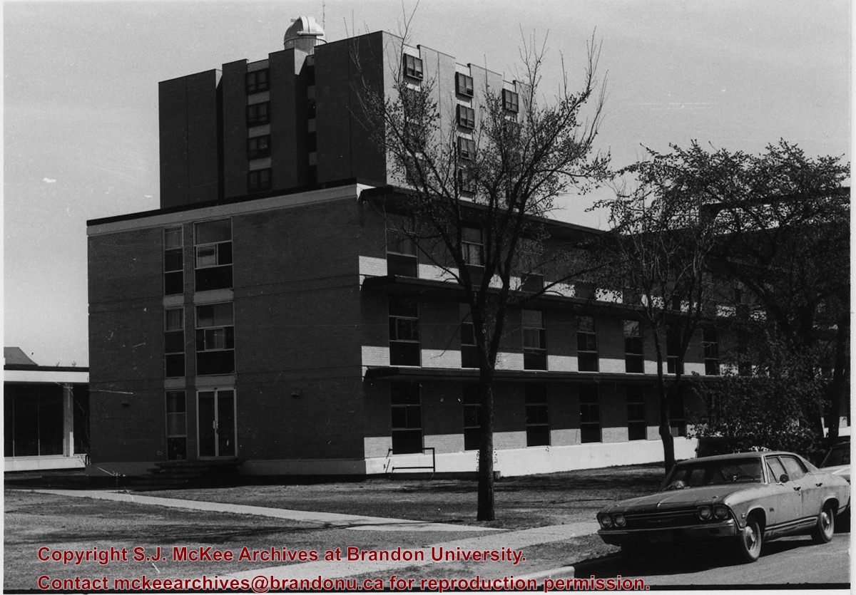
Photograph is looking west from the east side of 18th Street and shows Flora Cowan Hall, the link to the Main Dining Room, the Main Dining Room and Darrach Hall.
Images
Show Less

Residences and dining rooms

http://archives.brandonu.ca/en/permalink/descriptions8284
Part Of
BUPC 2 Campus buildings
Description Level
Sub-series
GMD
graphic
Date Range
late 1950s - early 1990s; predominant 1961-1978
Part Of
BUPC 2 Campus buildings
Description Level
Sub-series
Series Number
2.6
GMD
graphic
Date Range
late 1950s - early 1990s; predominant 1961-1978
Physical Description
60 photographs
History / Biographical
DARRACH HALL Darrach Hall is the men's residence and was completed in 1961. It is named after Robert and Sarah Darrach. FLORA COWAN HALL Flora Cowan Hall is the women's residence and was completed in 1962. It is named after Flora Cowan. MCMASTER HALL McMaster Hall is the co-ed residence and was completed in 1971. It is named in honour of Brandon College's association with McMaster University DINING ROOMS The Main Dining Room was completed in 1961 and is connected to all three residences either by a link (Flora Cowan Hall), the McMaster main concourse (McMaster Hall) or a hallway (Darrach Hall). Within the Main Dining room is the Louis Riel Room. The Louis Riel Room was previously the Small Dining Room, and later the Private Dining Room. It was renamed the Louis Riel Room in 2008 in honour of the Métis leader’s contribution to Manitoba history and heritage, as well as in honour of ongoing contributions to the University made by the Manitoba Métis Federation and the Louis Riel Institute. The room is often used to host dignitary dinners, awards and recognition ceremonies, seminar and conference sessions and other special events.
Scope and Content
Sub-series consists of photographs of Brandon College/University's three residences: Darrach Hall, Flora Cowan Hall and McMaster Hall, as well as images of the dining rooms.
Notes
History/Bio information for the Louis Riel Room was taken from the Brandon University website, available at: http://www.brandonu.ca/news (February 2008).
Show Less

Brandon College New Science Building - east elevation ( Citizens' Science Building)

http://archives.brandonu.ca/en/permalink/descriptions8302
Part Of
RG 6 Brandon University fonds
Description Level
Item
GMD
graphic
Date Range
February 1922
Part Of
RG 6 Brandon University fonds
Creator
Architect: Sproatt and Rolph (Toronto)
Description Level
Item
Series Number
2.1.1
Item Number
6
GMD
graphic
Date Range
February 1922
Physical Description
1 blueprint, 48 x 87 cm
Physical Condition
some water damage to right side of blueprint
Scope and Content
Blueprint - Brandon College Citizens' Science Building
Storage Location
RG 6 Brandon University fonds Series 2: Board of Governors 2.1 Documents
Show Less

East side 10th Street facing north from Princess Avenue, Brandon, Manitoba

http://archives.brandonu.ca/en/permalink/descriptions8376
Part Of
Joseph H. Hughes collection
Description Level
Item
GMD
graphic
Date Range
1962
Accession Number
3-1997
Part Of
Joseph H. Hughes collection
Description Level
Item
Series Number
3-1997.1
Item Number
3-1997.1.6
Accession Number
3-1997
GMD
graphic
Date Range
1962
Physical Description
8"x 10" (b/w)
Physical Condition
good
Scope and Content
Photograph of an east side of 10th Street facing north from Princess Avenue. Visible businesses include: Thunderbird Bowl, Canadian Pacific Telegraphs, Pittsburgh Paint & Glass, Strand Theatre, Trans Canada Credit Loans, Ted Heming Jewellers, Carlton Cafe, McKenzie Seeds, Clement Block, Mitrou's Cafe and Tea Room, and Brandon Musical Supply Ltd. Vehicles parked on 10th Street are facing north.
Notes
Photograph dated from "Tara's Bulba," the movie playing at the Strand Theatre and similiar vehicles captured in the photograph.
Name Access
Thunderbird Bowl
Canadian Pacific Telegraphs
Pittsburgh Paint & Glass
Strand Theatre
Trans Canada Credit Loans
Ted Heming Jewellers
Carlton Cafe
McKenzie Seeds
Clement Block
Mitrou Building
Brandon Musical Supply Ltd.
10th Street
Subject Access
downtowns
street scenes
Brandon business buildings & facilities after 1940
Storage Location
RG 5 photograph storage drawer
Images
Show Less

Princess Avenue facing east from 10th Street, Brandon, Manitoba

http://archives.brandonu.ca/en/permalink/descriptions8413
Part Of
Joseph H. Hughes collection
Description Level
Item
GMD
graphic
Date Range
c. 1965
Accession Number
3-1997
Part Of
Joseph H. Hughes collection
Description Level
Item
Series Number
3-1997.1
Item Number
3-1997.1.35
Accession Number
3-1997
GMD
graphic
Date Range
c. 1965
Physical Description
10" x 8" (b/w)
Physical Condition
good
Scope and Content
Photograph shows Princess Avenue facing east from 10th Street. On the north side of Princess Avenue, a B/A Service Station, Princess Cafe, Lindenberg Seeds, and the Central Fire Station are visible. Old City Hall with the war memorial and the Prince Edward Hotel are visible on the south side of Princess Avenue. Traffic is travelling one-way on Princess Avenue.
Name Access
Princess Avenue
City Hall
Prince Edward Hotel
B/A Service Station
Princess Cafe
Lindenberg Seeds
Central Fire Station
Subject Access
downtowns
street scenes
Brandon business buildings & facilities after 1940
building exteriors
hotels
garages
service stations
cafes
memorials
Storage Location
RG 5 photograph storage drawer
Images
Show Less

CPR engine terminal and north side east yard

http://archives.brandonu.ca/en/permalink/descriptions8716
Part Of
RG 11 Lawrence Stuckey fonds
Description Level
Item
GMD
graphic
Date Range
May 1939
Accession Number
1-2002
Part Of
RG 11 Lawrence Stuckey fonds
Creator
Lawrence Stuckey
Description Level
Item
Series Number
3.9
Item Number
1-2002.3.9.96
Accession Number
1-2002
GMD
graphic
Date Range
May 1939
Physical Description
5" x 8" (b/w)
History / Biographical
Stuckey's notes: Enl. Shop Buildings. Pub.: Mainline Modeller June 1990 p. 70-71.
Scope and Content
Photograph shows the CPR engine terminal and the north side of the east yard.
Notes
Corresponds with negative 1-2002.3.9.P18.
Repro Restriction
The McKee Archives is the copyright holder for the Stuckey materials.
Location Original
1-2002.3.1P18
Storage Location
RG 5 photograph storage drawer
Images
Show Less

Townhouses on 13th Steet East

http://archives.brandonu.ca/en/permalink/descriptions8730
Part Of
RG 11 Lawrence Stuckey fonds
Description Level
Item
GMD
graphic
Date Range
1971
Accession Number
1-2002
Part Of
RG 11 Lawrence Stuckey fonds
Description Level
Item
Series Number
3.9
Item Number
1-2002.3.9.108
Accession Number
1-2002
GMD
graphic
Date Range
1971
Physical Description
4.5" x 3.25" (b/w)
Scope and Content
Photograph is looking southeast and shows a townhouse complex located on the east side of 13th Avenue East. The buildings in the photograph are either Alpine Bay or Baker Bay townhouses.
Repro Restriction
The McKee Archives is the copyright holder for the Stuckey materials.
Location Original
1-2002.3.1CA15(3)
Storage Location
RG 5 photograph storage drawer
Images
Show Less

Townhouses on 13th Steet East

http://archives.brandonu.ca/en/permalink/descriptions8731
Part Of
RG 11 Lawrence Stuckey fonds
Description Level
Item
GMD
graphic
Date Range
1971
Accession Number
1-2002
Part Of
RG 11 Lawrence Stuckey fonds
Description Level
Item
Series Number
3.9
Item Number
1-2002.3.9.109
Accession Number
1-2002
GMD
graphic
Date Range
1971
Physical Description
4.5" x 3.25" (b/w)
Scope and Content
Photograph is looking northeast and shows a number of townhouse complexes located on the east side of 13th Avenue East. The buildings in the photograph are Alpine Bay townhouses.
Repro Restriction
The McKee Archives is the copyright holder for the Stuckey materials.
Location Original
1-2002.3.1CA15(4)
Storage Location
RG 5 photograph storage drawer
Images
Show Less

Townhouses on Lorne Avenue East

http://archives.brandonu.ca/en/permalink/descriptions8732
Part Of
RG 11 Lawrence Stuckey fonds
Description Level
Item
GMD
graphic
Date Range
1971
Accession Number
1-2002
Part Of
RG 11 Lawrence Stuckey fonds
Description Level
Item
Series Number
3.9
Item Number
1-2002.3.9.110
Accession Number
1-2002
GMD
graphic
Date Range
1971
Physical Description
4.5" x 3.25" (b/w)
Scope and Content
Photograph is looking east down Lorne Avenue East from approximately the 13th Avenue East intersection. On the north side of the street are the Hillside Townhouses with the Lady Sylvia apartment block and Simplot Canada Ltd. in the background.
Repro Restriction
The McKee Archives is the copyright holder for the Stuckey materials.
Location Original
1-2002.3.1CA15(2)
Storage Location
RG 5 photograph storage drawer
Images
Show Less

T. Eaton's Co. Limited main floor

http://archives.brandonu.ca/en/permalink/descriptions8743
Part Of
RG 11 Lawrence Stuckey fonds
Description Level
Item
GMD
graphic
Date Range
[n.d.]
Accession Number
1-2002
Part Of
RG 11 Lawrence Stuckey fonds
Creator
Clark J. Smith (?)
Description Level
Item
Series Number
3.9
Item Number
1-2002.3.9.121
Accession Number
1-2002
GMD
graphic
Date Range
[n.d.]
Physical Description
8" x 10" (b/w)
History / Biographical
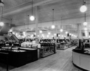
The Eaton's store was located at the southwest corner of 7th Street and Rosser Avenue. The store closed c. 1997 and since 2000 the building has been occupied by the Art Gallery of Southwestern Manitoba and the Brandon Public Library.
Scope and Content
Photograph shows the main floor of Brandon's Eaton's store. Various displays, the gift wrapping centre and staircase to the basement or second floor are visible.
Repro Restriction
The McKee Archives is the copyright holder for the Stuckey materials.
Storage Location
RG 5 photograph storage drawer
Images
Show Less

10th street power plant control room

http://archives.brandonu.ca/en/permalink/descriptions8764
Part Of
RG 11 Lawrence Stuckey fonds
Description Level
Item
GMD
graphic
Date Range
[n.d.]
Accession Number
1-2002
Part Of
RG 11 Lawrence Stuckey fonds
Creator
Clark J. Smith
Description Level
Item
Series Number
3.9
Item Number
1-2002.3.9.131
Accession Number
1-2002
GMD
graphic
Date Range
[n.d.]
Physical Description
8" x 10" (b/w)
Scope and Content
Photograph of the control room of the 10th Street Power Plant.
Repro Restriction
The McKee Archives is the copyright holder for the Stuckey materials.
Storage Location
RG 5 photograph storage drawer
Images
Show Less

10th street power plant control room

http://archives.brandonu.ca/en/permalink/descriptions8765
Part Of
RG 11 Lawrence Stuckey fonds
Description Level
Item
GMD
graphic
Date Range
[n.d.]
Accession Number
1-2002
Part Of
RG 11 Lawrence Stuckey fonds
Creator
Clark J. Smith
Description Level
Item
Series Number
3.9
Item Number
1-2002.3.9.132
Accession Number
1-2002
GMD
graphic
Date Range
[n.d.]
Physical Description
8" x 10" (b/w)
Scope and Content
Photograph of the control room of the 10th Street Power Plant.
Repro Restriction
The McKee Archives is the copyright holder for the Stuckey materials.
Storage Location
RG 5 photograph storage drawer
Images
Show Less

Police station and court room

http://archives.brandonu.ca/en/permalink/descriptions8768
Part Of
RG 11 Lawrence Stuckey fonds
Description Level
Item
GMD
graphic
Date Range
c. 1980
Accession Number
1-2002
Part Of
RG 11 Lawrence Stuckey fonds
Creator
Lawrence Stuckey
Description Level
Item
Series Number
3.9
Item Number
1-2002.3.9.143
Accession Number
1-2002
GMD
graphic
Date Range
c. 1980
Physical Description
8" x 7.5" (b/w)
History / Biographical
The Police Station and Court House were located on the east side of 8th Street in the 200 block between the new YMCA building and First Church United. The building that house the Police Station and Court House was the old YMCA building (they removed the front columns during renovations).
Scope and Content
Photograph is looking east north east and shows the Police Station and Court House main entrance. The building also housed City Welfare. A private parking sign for First Church United is visible in the bottom left corner.
Repro Restriction
The McKee Archives is the copyright holder for the Stuckey materials.
Storage Location
RG 5 photograph storage drawer
Images
Show Less

View of CPR east from overhead bridge

http://archives.brandonu.ca/en/permalink/descriptions8781
Part Of
RG 11 Lawrence Stuckey fonds
Description Level
Item
GMD
graphic
Date Range
1913
Accession Number
1-2002
Part Of
RG 11 Lawrence Stuckey fonds
Description Level
Item
Series Number
3.9
Item Number
1-2002.3.9.156
Accession Number
1-2002
GMD
graphic
Date Range
1913
Physical Description
9.5" x 6.75" (b/w)
History / Biographical
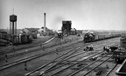
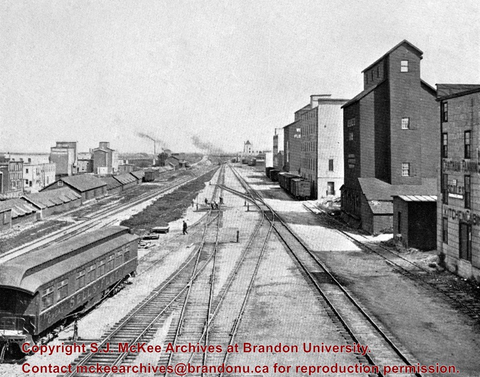
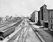
Stuckey's notes: In foreground is publicity coach of Sells-Floto Circus. On left the long row of domestic fuel coal sheds (many of which were later burned), Hanbury's Mill, elevators & Maple Leaf flour mill. On right elevator & Hanbury Hardware (in 1985 used by Christie School Supply).
Scope and Content
Photograph is looking east along the CPR tracks.
Notes
Corresponds with negative 1-2002.3.9.P11.
Repro Restriction
The McKee Archives is the copyright holder for the Stuckey materials.
Location Original
6-1999.16
Storage Location
RG 5 photograph storage drawer
Images
Show Less

20 records – page 1 of 1.