Skip header and navigation

Revise Search

20 records – page 1 of 1.

Westman Recycling Council fonds

http://archives.brandonu.ca/en/permalink/descriptions12346
Part Of
RG 5 Western Manitoba Manuscript Collection
Description Level
Fonds
GMD
textual records
Date Range
November 15, 1989 - March 26, 2009
Accession Number
14-2011
Part Of
RG 5 Western Manitoba Manuscript Collection
Description Level
Fonds
Accession Number
14-2011
GMD
textual records
Date Range
November 15, 1989 - March 26, 2009
Physical Description
90 cm
History / Biographical
The Westman Recycling Council was started by a small group of avid recyclers with financial and volunteer help from the Kiwanis Club of Brandon, among others. Volunteers organized the first outdoor recycling depots in June and October 1989. The first event with recorded minutes was the first annual meeting, November 15, 1989. The organization was incorporated in February 1990, and became a registered charity in 1995. The Mission Statement was: "to support and promote the reduction, re-use, and recycling of material resources for the benefit of Westman's environment and future generations." The major partner in the work of the organization was the City of Brandon. In 2003, Westman Recycling, in partnership with the City, built a Material Recovery Facility (MRF) at the Brandon Landfill; Westman Recycling owned the building on the City-owned land. It was a $4 million structure - financed by federal and provincial grants (about one-quarter of the total) and a mortgage (about three-quarters). Details are in the Board and other Committee minutes and agreements. In late 2005, Westman Recycling faced a severe cash crunch - as a result of poor markets for recyclables, changes in support funding from the Manitoba Product Stewardship Corporation (MPSC), and a drop in public recycling levels. In February 2006, the City decided to sign a contract with another organization to operate the MRF; after that there appeared to be no role for Westman Recycling. A general meeting on September 22, 2008 voted to dissolve the organization. At that meeting, the suggestion was made (agreed to by consensus) that the files of the organization be donated to Brandon University to be made available for researchers. A Board of Directors meeting on the same date voted to donate all remaining funds to a perpetual "Westman Recycling" fund with the Brandon Area Community Foundation. A final wind-up meeting was held on March 26, 2009
Custodial History
The organization was overseen by volunteers / volunteer Board of Directors. The files were first held by volunteers / Board members in their homes. In May 1991, the organization hired David McConkey as Coordinator / General Manager, who was directed by the Board to manage the files on a daily basis from that date forward. The files were kept in the organization's rented office space in the 1300 block of Pacific Avenue from May 1991 to September 1992, and then in the rented space in the Massey building at 6th Street and Pacific Avenue. The files were kept at the new facility at the landfill from April 2003 to February 2006. They were then stored in the basement of the Marquis Project, 912 Rosser Avenue, until August 2011 when they were donated to the S.J. McKee Archives, Brandon University. Some files (e.g. minutes from 1995-96) were found to be missing entirely. Other files were disposed of by recycling and/or shredding as they were judged to be confidential (e.g. personnel), of an ordinary business nature only (e.g. invoices), or not useful for future research (e.g. extra copies, routine correspondence, building and equipment plans and other arrangements).
Scope and Content
Fonds consists of records that document the origin, activities, demise, and legacy of the Westman Recycling Council. Records include minutes, financial summaries, scrapbooks, newsletters, brochures, media clippings, photographs and miscellaneous documents related to the construction in collaboration with the City of Brandon of Brandon's principal recycling facility.
Notes
Administrative history courtesy David McConkey. See additional notes on the organization in the curatorial file. Description by Tom Mitchell.
Storage Location
2011 accessions
Show Less

Brandon Sno-Goers Snowmobile Club fonds

http://archives.brandonu.ca/en/permalink/descriptions7972
Part Of
RG 5 Western Manitoba Manuscript Collection
Description Level
Collection
GMD
multiple media
Date Range
1970-1999
Accession Number
35-2007
Part Of
RG 5 Western Manitoba Manuscript Collection
Description Level
Collection
Accession Number
35-2007
GMD
multiple media
Date Range
1970-1999
Physical Description
30 cm textual records; artifacts
Physical Condition
Good.
History / Biographical
The Brandon Sno-Goers Snowmobile Club was created in approximately 1970 and was disbanded in approximately 2002. During its lifetime, the Sno-Goers were an organization dedicated to the promotion of recreational snowmobiling. They were also a community service group, which raised funds for local charities, held many winter events and worked with E.M.O. services in the southwestern area of Manitoba. They were members of the provincial organization Sno-Man Inc (Snowmobilers of Manitoba Inc.).
Custodial History
Records were donated to the McKee Archives on September 9, 2005 by Lloyd Shortridge, former president and Sno-Goers member from 1986-2002. The records were in Shortridge's residence prior to their donation.
Scope and Content
Fonds consists of minutes (annual meetings, general meetings, director's meetings, club meetings etc.), newsletters, financial records, member lists, correspondence, records related to various club activities, events, and charity fundraising. It also includes the Manitoba snowmobile operator's training manual, exam and answer key, information on snow trails and trail grooming and records for the 1989 Sno-Man convention and sled show hosted by the Brandon Sno-Goers. Fonds contains a number of artifacts, including: 3 pins, 2 badges and the Sno-Goers' flag. Fundraising included: Heart & Stroke Foundation (Heart Fund Ride), Multiple Sclerosis Society of Canada (Poker Derby), Canadian Liver Foundation, Ability Fund March of Dimes, City of Brandon, Canadian Cancer Society, Dreams for Kids.
Notes
Description by Christy Henry. All records related to Snopasses (except a few annual reports) were culled, as were recipets and duplicates, Sno-Man newsletters and Sno-Man meeting minutes.
Storage Location
2007 accessions
Storage Range
2007 accessions
Arrangement
There are some financial records mixed in with the minutes in 1983-1985. There are some minutes for 1980 in the correspondence file.
Show Less

Aerial view - Brandon University campus

http://archives.brandonu.ca/en/permalink/descriptions7989
Part Of
Brandon University Photograph collection
Description Level
Item
GMD
graphic
Date Range
c. 2000
Part Of
Brandon University Photograph collection
Creator
Photograph commissioned by Brandon University and taken by Yourview Aerial Scenics Ltd.
Description Level
Item
Series Number
2.1
Item Number
BUPC 2.1.55
GMD
graphic
Date Range
c. 2000
Physical Description
6" x 4" (colour)
Scope and Content
View is southwest from approximatley 16th Street between Princess and Rosser Avenues. Photograph shows the Brandon University campus, as well as surrounding residential blocks, including Flemming, J.R. Reid and Vincent Massey schools.
Subject Access
aerial photographs
campus photographs
campus buildings
Brandon streets
Images
Show Less

Aerial view - Brandon University campus

http://archives.brandonu.ca/en/permalink/descriptions7990
Part Of
Brandon University Photograph collection
Description Level
Item
GMD
graphic
Date Range
c. 2000
Part Of
Brandon University Photograph collection
Creator
Photograph commissioned by Brandon University and taken by Yourview Aerial Scenics Ltd.
Description Level
Item
Series Number
2.1
Item Number
BUPC 2.1.56
GMD
graphic
Date Range
c. 2000
Physical Description
6" x 4" (colour)
Scope and Content
View is west southwest from approximatley 16th Street between Princess and Lorne Avenues. Photograph shows the Brandon University campus, as well as surrounding residential blocks between 16th and 23rd Streets, Princess and Louise Avenues..
Subject Access
aerial photographs
campus photographs
campus buildings
Brandon streets
Images
Show Less

Aerial view - Brandon University campus

http://archives.brandonu.ca/en/permalink/descriptions7991
Part Of
Brandon University Photograph collection
Description Level
Item
GMD
graphic
Date Range
c. 2000
Part Of
Brandon University Photograph collection
Creator
Photograph commissioned by Brandon University and taken by Yourview Aerial Scenics Ltd.
Description Level
Item
Series Number
2.1
Item Number
BUPC 2.1.57
GMD
graphic
Date Range
c. 2000
Physical Description
6" x 4" (colour)
Scope and Content
View is west from approximatley 17th Street between Lorne and Louise Avenues. Photograph shows a portion of the Brandon University campus (excluding the Education Building and anything north of it), as well as surrounding residential blocks from approximatley 17th Street to 22nd Street.
Subject Access
aerial photographs
campus photographs
campus buildings
Brandon streets
Images
Show Less

Aerial view - Brandon University campus

http://archives.brandonu.ca/en/permalink/descriptions7992
Part Of
Brandon University Photograph collection
Description Level
Item
GMD
graphic
Date Range
c. 1990
Part Of
Brandon University Photograph collection
Description Level
Item
Series Number
2.1
Item Number
BUPC 2.1.58
GMD
graphic
Date Range
c. 1990
Physical Description
5" x 3.5" (colour)
Scope and Content
View is west northwest from approximatley 16th Street and Louise Avenue. Photograph shows the Brandon University campus, prior to the Library Extension, and a large portion of the city to the west of the campus.
Subject Access
aerial photographs
campus photographs
campus buildings
Brandon streets
Images
Show Less

Aerial view - Brandon University campus

http://archives.brandonu.ca/en/permalink/descriptions7993
Part Of
Brandon University Photograph collection
Description Level
Item
GMD
graphic
Date Range
c. 1990
Part Of
Brandon University Photograph collection
Description Level
Item
Series Number
2.1
Item Number
BUPC 2.1.59
GMD
graphic
Date Range
c. 1990
Physical Description
5" x 3.5" (colour)
Scope and Content
View is northwest from approximatley 16th Street and Louise Avenue. Photograph shows the Brandon University campus, prior to the Library Extension, and a large portion of the city to the west of the campus.
Subject Access
aerial photographs
campus photographs
campus buildings
Brandon streets
Show Less
Part Of
Brandon University Photograph collection
Description Level
Item
GMD
graphic
Date Range
c. 1985
Part Of
Brandon University Photograph collection
Description Level
Item
Series Number
2.1
Item Number
BUPC 2.1.60
GMD
graphic
Date Range
c. 1985
Physical Description
5" x 3.5" (colour)
Scope and Content
Photograph shows the removal of one of the houses formerly located on 20th Street between Louise and Princess Avenues. The houses on those blocks were removed to create parking lots for the University. A Fed Zavislak Ltd. Well Drilling & Trucking pickup truck is visible at the curb.
Subject Access
campus photographs
Brandon streets
Images
Show Less
Part Of
Brandon University Photograph collection
Description Level
Item
GMD
graphic
Date Range
c. 1985
Part Of
Brandon University Photograph collection
Description Level
Item
Series Number
2.1
Item Number
BUPC 2.1.61
GMD
graphic
Date Range
c. 1985
Physical Description
5" x 3.5" (colour)
Scope and Content
Photograph shows the removal of one of the houses formerly located on 20th Street between Louise and Princess Avenues. The houses on those blocks were removed to create parking lots for the University.
Subject Access
campus photographs
Brandon streets
Images
Show Less

Brandon University campus

http://archives.brandonu.ca/en/permalink/descriptions7997
Part Of
Brandon University Photograph collection
Description Level
Item
GMD
graphic
Date Range
c. 1996
Part Of
Brandon University Photograph collection
Creator
Photographer: Sandy Black
Description Level
Item
Series Number
2.1
Item Number
BUPC 2.1.63
GMD
graphic
Date Range
c. 1996
Physical Description
6" x 4" (colour)
Scope and Content
View is northwest from the roof of the John R. Brodie Science Centre. Photograph shows the roof of the Knowles Douglas Students' Union Centre, the Citizens' Science Building, and the Brandon College Building and Clark Hall during renovation.
Subject Access
campus photographs
campus buildings
campus construction
Images
Show Less

Brandon University campus

http://archives.brandonu.ca/en/permalink/descriptions7998
Part Of
Brandon University Photograph collection
Description Level
Item
GMD
graphic
Date Range
c. 1993
Part Of
Brandon University Photograph collection
Description Level
Item
Series Number
2.1
Item Number
BUPC 2.1.64
GMD
graphic
Date Range
c. 1993
Physical Description
6" x 4" (colour)
Scope and Content
Photograph was taken from the roof of the Library and shows the walkway and flower bed on the southeast corner of the George T. Richardson Centre. The Physical Plant H-Hut is visible in the top right hand corner.
Subject Access
campus photographs
Images
Show Less

Brandon University campus

http://archives.brandonu.ca/en/permalink/descriptions7999
Part Of
Brandon University Photograph collection
Description Level
Item
GMD
graphic
Date Range
c. 1993
Part Of
Brandon University Photograph collection
Description Level
Item
Series Number
2.1
Item Number
BUPC 2.1.65
GMD
graphic
Date Range
c. 1993
Physical Description
4" x 6" (colour)
Scope and Content
View is southwest from the roof of the George T. Richardson Centre. Photograph shows the curved glass wall of the John E. Robbins Library, the walkway between the Library and the Dining Hall, the Dining Hall and Darrach Hall.
Subject Access
campus photographs
campus buildings
Images
Show Less

Brandon University campus construction

http://archives.brandonu.ca/en/permalink/descriptions8000
Part Of
Brandon University Photograph collection
Description Level
Item
GMD
graphic
Date Range
c. 1996
Part Of
Brandon University Photograph collection
Creator
Photographer: Sandy Black
Description Level
Item
Series Number
2.1
Item Number
BUPC 2.1.66
GMD
graphic
Date Range
c. 1996
Physical Description
6" x 4" (colour)
Scope and Content
View is southeast from the roof of the A.E. McKenzie Building. Photograph shows the construction of the extension of Clark Hall and the skywalk.
Subject Access
campus photographs
campus buildings
campus construction
Images
Show Less

Brandon University campus construction

http://archives.brandonu.ca/en/permalink/descriptions8001
Part Of
Brandon University Photograph collection
Description Level
Item
GMD
graphic
Date Range
c. 1996
Part Of
Brandon University Photograph collection
Creator
Photographer: Sandy Black
Description Level
Item
Series Number
2.1
Item Number
BUPC 2.1.67
GMD
graphic
Date Range
c. 1996
Physical Description
6" x 4" (colour)
Scope and Content
View is north probably from the roof of McMaster Hall. Photograph shows the construction of the extension of Clark Hall and the skywalk.
Subject Access
campus photographs
campus buildings
campus construction
Images
Show Less

Brandon University campus construction

http://archives.brandonu.ca/en/permalink/descriptions8002
Part Of
Brandon University Photograph collection
Description Level
Item
GMD
graphic
Date Range
c. 1996
Part Of
Brandon University Photograph collection
Creator
Photographer: Sandy Black
Description Level
Item
Series Number
2.1
Item Number
BUPC 2.1.68
GMD
graphic
Date Range
c. 1996
Physical Description
6" x 4" (colour)
Scope and Content
View is north probably from the roof of McMaster Hall. Photograph shows the construction of the new roof on Clark Hall and the Brandon College Building.
Subject Access
campus photographs
campus buildings
campus construction
Images
Show Less

Brandon University campus construction

http://archives.brandonu.ca/en/permalink/descriptions8003
Part Of
Brandon University Photograph collection
Description Level
Item
GMD
graphic
Date Range
c. 1996
Part Of
Brandon University Photograph collection
Description Level
Item
Series Number
2.1
Item Number
2.1.69
GMD
graphic
Date Range
c. 1996
Physical Description
6" x 4" (colour)
Scope and Content
View is southwest from Clark Hall. Photograph shows the construction of the extension of Clark Hall.
Subject Access
campus photographs
campus buildings
campus construction
Images
Show Less

Brandon University campus construction

http://archives.brandonu.ca/en/permalink/descriptions8004
Part Of
Brandon University Photograph collection
Description Level
Item
GMD
graphic
Date Range
c. 1996
Part Of
Brandon University Photograph collection
Creator
Photographer: Sandy Black
Description Level
Item
Series Number
2.1
Item Number
BUPC 2.1.70
GMD
graphic
Date Range
c. 1996
Physical Description
6" x 4" (colour)
Scope and Content
View is north probably from the roof of McMaster Hall. Photograph shows the construction of the extension to Clark Hall and the skywalk. Also visible are the A.E. McKenzie Building, the Brandon College Building, the Education Building, the original Music Building and the Western Manitoba Centennial Auditorium, as well as the walkway that runs north between the buildings and the courtyard.
Subject Access
campus photographs
campus buildings
campus construction
Show Less

Brandon University campus construction

http://archives.brandonu.ca/en/permalink/descriptions8005
Part Of
Brandon University Photograph collection
Description Level
Item
GMD
graphic
Date Range
c. 1996
Part Of
Brandon University Photograph collection
Creator
Photographer: Sandy Black
Description Level
Item
Series Number
2.1
Item Number
BUPC 2.1.71
GMD
graphic
Date Range
c. 1996
Physical Description
4" x 6" (colour)
Scope and Content
View is northeast probably from the roof of McMaster Hall. Photograph shows the construction of the new roof on Clark Hall and the Brandon College Building. A portion of the east side of the 000 and 100 blocks of 18th Street, as well as the corner of 18th Street and Rosser Avenue are visible in the upper left hand corner. This includes the "Downtown Brandon" sign.
Subject Access
campus photographs
campus buildings
campus construction
Brandon streets
Images
Show Less

Brandon University campus construction

http://archives.brandonu.ca/en/permalink/descriptions8006
Part Of
Brandon University Photograph collection
Description Level
Item
GMD
graphic
Date Range
c. 1996
Part Of
Brandon University Photograph collection
Creator
Photographer: Sandy Black
Description Level
Item
Series Number
2.1
Item Number
BUPC 2.1.72
GMD
graphic
Date Range
c. 1996
Physical Description
6" x 4" (colour)
Scope and Content
View is north northeast probably from the roof of McMaster Hall. Photograph shows the construction of the new roof on Clark Hall and the Brandon College Building, as well as the construction of the extension to Clark Hall and the skywalk. Portions of the city as far north as the Assiniboine River are also visible.
Subject Access
campus photographs
campus buildings
campus construction
Brandon streets
Images
Show Less

Brandon University campus construction

http://archives.brandonu.ca/en/permalink/descriptions8007
Part Of
Brandon University Photograph collection
Description Level
Item
GMD
graphic
Date Range
c. 1996
Part Of
Brandon University Photograph collection
Description Level
Item
Series Number
2.1
Item Number
BUPC 2.1.73
GMD
graphic
Date Range
c. 1996
Physical Description
6" x 4" (colour)
Scope and Content
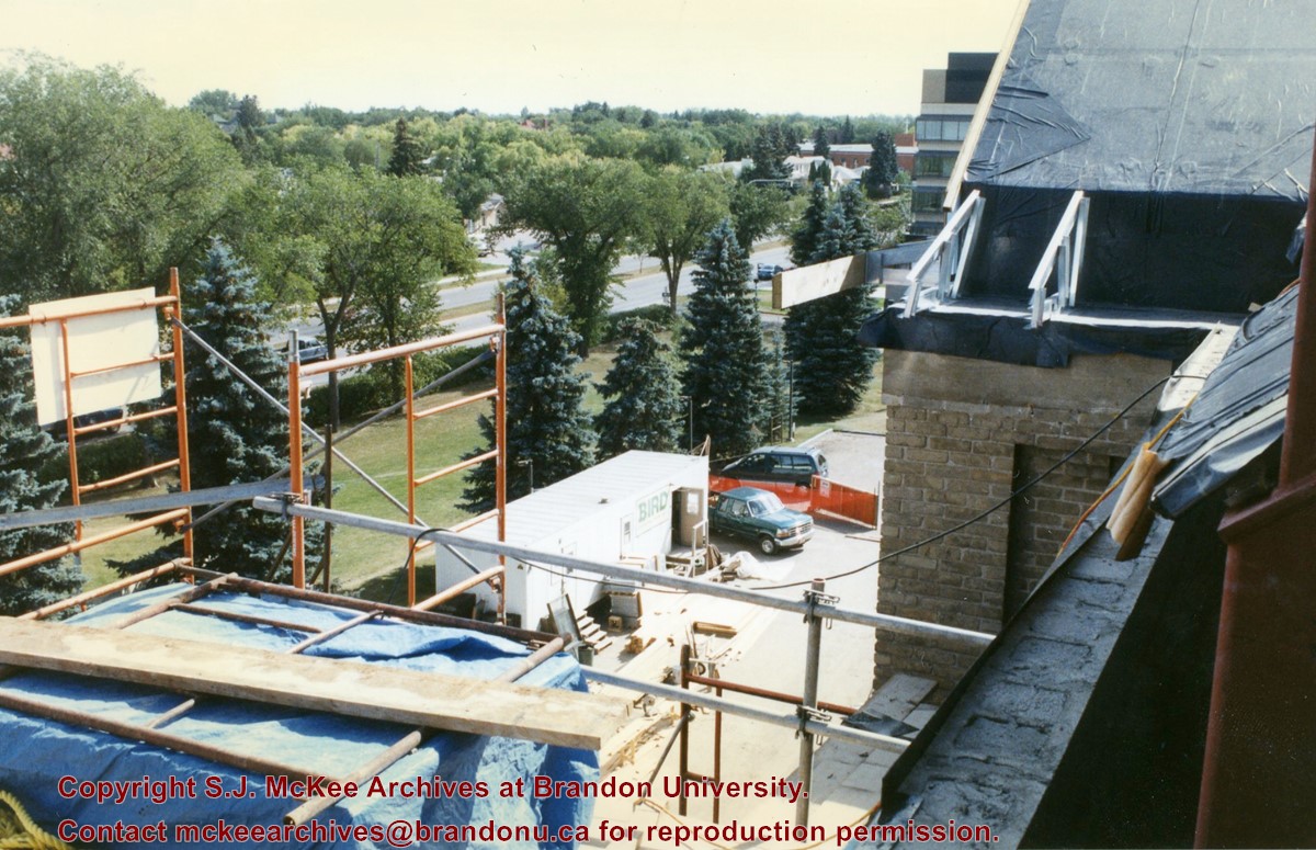
View is southeast from the roof of Clark Hall. Photograph shows some of the scaffolding and materials, as well as the construction trailer (Bird Construction) located on the driveway during the restoration of Clark Hall and the Brandon College Building.
Subject Access
campus photographs
campus construction
Images
Show Less

20 records – page 1 of 1.