Skip header and navigation

Revise Search

20 records – page 1 of 1.

View from 1st street bridge looking west

http://archives.brandonu.ca/en/permalink/descriptions6438
Part Of
Alf Fowler collection
Description Level
Item
GMD
graphic
Date Range
ca. 1911
Accession Number
6-1999
Part Of
Alf Fowler collection
Creator
Davidson & Gowen
Description Level
Item
Item Number
6-1999.13
Accession Number
6-1999
GMD
graphic
Date Range
ca. 1911
Physical Description
9.5" x 7.5" (b/w)
Custodial History
See fonds level description of the Alf Fowler collection for custodial history.
Scope and Content
Photo shows Brandon from the 1st Street bridge, looking west. Massey-Harris Co. Limited and the Cockshutt Plow Company Limited are visible.
Storage Range
RG 5 Western Manitoba Manuscript collection - photograph storage drawer
Images
Show Less

View east-southeast from tower of Brandon Brewery

http://archives.brandonu.ca/en/permalink/descriptions6440
Part Of
Alf Fowler collection
Description Level
Item
GMD
graphic
Date Range
ca. 1911
Accession Number
6-1999
Part Of
Alf Fowler collection
Creator
Davidson & Gowen
Description Level
Item
Item Number
6-1999.15
Accession Number
6-1999
GMD
graphic
Date Range
ca. 1911
Physical Description
9.5" x 7.25" (b/w)
Custodial History
See fonds level description of the Alf Fowler collection for custodial history.
Scope and Content
Photo shows view east-southeast from tower of Brandon Brewery. Assiniboine Avenue and the west ramp of the Overhead bridge are visible.
Storage Range
RG 5 Western Manitoba Manuscript collection - photograph storage drawer
Images
Show Less

Industrial building on the Exhibition grounds

http://archives.brandonu.ca/en/permalink/descriptions6486
Part Of
Alf Fowler collection
Description Level
Item
GMD
graphic
Date Range
ca. 1911
Accession Number
6-1999
Part Of
Alf Fowler collection
Creator
Davidson & Gowen
Description Level
Item
Item Number
6-1999.61
Accession Number
6-1999
GMD
graphic
Date Range
ca. 1911
Physical Description
9" x 7" (b/w)
Custodial History
See fonds level description of the Alf Fowler collection for custodial history.
Scope and Content
Photo shows an industrial building on the Exhibition grounds (now the Keystone Grounds).
Storage Range
RG 5 Western Manitoba Manuscript collection - photograph storage drawer
Images
Show Less

Winter Fair building

http://archives.brandonu.ca/en/permalink/descriptions6487
Part Of
Alf Fowler collection
Description Level
Item
GMD
graphic
Date Range
ca. 1911
Accession Number
6-1999
Part Of
Alf Fowler collection
Creator
Davidson & Gowen
Description Level
Item
Item Number
6-1999.62
Accession Number
6-1999
GMD
graphic
Date Range
ca. 1911
Physical Description
9" x 5.25" (b/w)
Custodial History
See fonds level description of the Alf Fowler collection for custodial history.
Scope and Content
Photo shows one of the Winter Fair buildings on 10th Street.
Storage Range
RG 5 Western Manitoba Manuscript collection - photograph storage drawer
Images
Show Less

Bird's eye view - Experimental Farm

http://archives.brandonu.ca/en/permalink/descriptions6512
Part Of
Alf Fowler collection
Description Level
Item
GMD
graphic
Date Range
ca. 1911
Accession Number
6-1999
Part Of
Alf Fowler collection
Creator
Davidson & Gowen
Description Level
Item
Item Number
6-1999.88
Accession Number
6-1999
GMD
graphic
Date Range
ca. 1911
Physical Description
9.25" x 7.25" (b/w)
Custodial History
See fonds level description of the Alf Fowler collection for custodial history.
Scope and Content
Photo shows a bird's eye view from the Experimental Farm, looking southeast. Fields in the foreground, with Brandon in the background.
Storage Range
RG 5 Western Manitoba Manuscript collection - photograph storage drawer
Images
Show Less

Phillip Isotalo at the Science Fair

http://archives.brandonu.ca/en/permalink/descriptions7934
Part Of
Brandon and Area Photograph Collection
Description Level
Item
GMD
graphic
Date Range
[198?]
Part Of
Brandon and Area Photograph Collection
Description Level
Item
Series Number
4
Item Number
BAPC 4.32
GMD
graphic
Date Range
[198?]
Physical Description
5" x 7" (b/w)
Scope and Content
Photograph shows Phillip Isotalo with his project Lepidoptera at the Science Fair.
Storage Location
Brandon and Area photograph collection
Images
Show Less

Aerial view - Brandon University campus

http://archives.brandonu.ca/en/permalink/descriptions7989
Part Of
Brandon University Photograph collection
Description Level
Item
GMD
graphic
Date Range
c. 2000
Part Of
Brandon University Photograph collection
Creator
Photograph commissioned by Brandon University and taken by Yourview Aerial Scenics Ltd.
Description Level
Item
Series Number
2.1
Item Number
BUPC 2.1.55
GMD
graphic
Date Range
c. 2000
Physical Description
6" x 4" (colour)
Scope and Content
View is southwest from approximatley 16th Street between Princess and Rosser Avenues. Photograph shows the Brandon University campus, as well as surrounding residential blocks, including Flemming, J.R. Reid and Vincent Massey schools.
Subject Access
aerial photographs
campus photographs
campus buildings
Brandon streets
Images
Show Less

Aerial view - Brandon University campus

http://archives.brandonu.ca/en/permalink/descriptions7990
Part Of
Brandon University Photograph collection
Description Level
Item
GMD
graphic
Date Range
c. 2000
Part Of
Brandon University Photograph collection
Creator
Photograph commissioned by Brandon University and taken by Yourview Aerial Scenics Ltd.
Description Level
Item
Series Number
2.1
Item Number
BUPC 2.1.56
GMD
graphic
Date Range
c. 2000
Physical Description
6" x 4" (colour)
Scope and Content
View is west southwest from approximatley 16th Street between Princess and Lorne Avenues. Photograph shows the Brandon University campus, as well as surrounding residential blocks between 16th and 23rd Streets, Princess and Louise Avenues..
Subject Access
aerial photographs
campus photographs
campus buildings
Brandon streets
Images
Show Less

Aerial view - Brandon University campus

http://archives.brandonu.ca/en/permalink/descriptions7991
Part Of
Brandon University Photograph collection
Description Level
Item
GMD
graphic
Date Range
c. 2000
Part Of
Brandon University Photograph collection
Creator
Photograph commissioned by Brandon University and taken by Yourview Aerial Scenics Ltd.
Description Level
Item
Series Number
2.1
Item Number
BUPC 2.1.57
GMD
graphic
Date Range
c. 2000
Physical Description
6" x 4" (colour)
Scope and Content
View is west from approximatley 17th Street between Lorne and Louise Avenues. Photograph shows a portion of the Brandon University campus (excluding the Education Building and anything north of it), as well as surrounding residential blocks from approximatley 17th Street to 22nd Street.
Subject Access
aerial photographs
campus photographs
campus buildings
Brandon streets
Images
Show Less

Aerial view - Brandon University campus

http://archives.brandonu.ca/en/permalink/descriptions7992
Part Of
Brandon University Photograph collection
Description Level
Item
GMD
graphic
Date Range
c. 1990
Part Of
Brandon University Photograph collection
Description Level
Item
Series Number
2.1
Item Number
BUPC 2.1.58
GMD
graphic
Date Range
c. 1990
Physical Description
5" x 3.5" (colour)
Scope and Content
View is west northwest from approximatley 16th Street and Louise Avenue. Photograph shows the Brandon University campus, prior to the Library Extension, and a large portion of the city to the west of the campus.
Subject Access
aerial photographs
campus photographs
campus buildings
Brandon streets
Images
Show Less

Aerial view: Brandon University campus

http://archives.brandonu.ca/en/permalink/descriptions8046
Part Of
Aerial views and campus photographs
Description Level
Item
GMD
graphic
Date Range
late 1970s
Part Of
Aerial views and campus photographs
Description Level
Item
Series Number
2.1
Item Number
2.1.115
GMD
graphic
Date Range
late 1970s
Physical Description
5" x 3.5" (colour)
Scope and Content
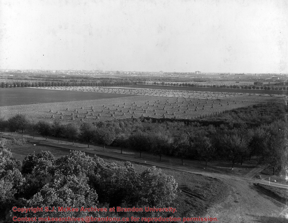
View is southwest from approximately Princess Avenue and 17th Street. Photograph shows the Brandon University campus in fall, as well as the southwest portion of the city.
Images
Show Less

Aerial view: Brandon University campus

http://archives.brandonu.ca/en/permalink/descriptions8047
Part Of
Aerial views and campus photographs
Description Level
Item
GMD
graphic
Date Range
1967-1969
Part Of
Aerial views and campus photographs
Description Level
Item
Series Number
2.1
Item Number
2.1.116
GMD
graphic
Date Range
1967-1969
Physical Description
5" x 4" (colour)
Scope and Content
View is south southwest from approximatley the east corner of 18th Street and Princess Avenue. Photograph shows the Brandon University campus, Kinsmen Stadium, Earl Oxford school and a number of residential blocks, particularly southwest of 18th Street.
Images
Show Less

Aerial view: Brandon University campus

http://archives.brandonu.ca/en/permalink/descriptions8048
Part Of
Aerial views and campus photographs
Description Level
Item
GMD
graphic
Date Range
1967-1969
Part Of
Aerial views and campus photographs
Description Level
Item
Series Number
2.1
Item Number
2.1.117
GMD
graphic
Date Range
1967-1969
Physical Description
5" x 4" (colour)
Scope and Content
View is southeast from approximatley 23rd Street and Rosser Avenue. Photograph shows the Brandon University campus, Kinsmen Stadium, Earl Oxford school, the Fair Grounds (including the Grandstand and Racetrack) and a number of residential blocks, particularly in the southeast part of the city.
Images
Show Less

Aerial view: Brandon University campus

http://archives.brandonu.ca/en/permalink/descriptions8049
Part Of
Aerial views and campus photographs
Description Level
Item
GMD
graphic
Date Range
1967-1969
Part Of
Aerial views and campus photographs
Description Level
Item
Series Number
2.1
Item Number
2.1.118
GMD
graphic
Date Range
1967-1969
Physical Description
5" x 3.5" (colour)
Scope and Content
View is west from 17th Street between Louise and Princess Avenues. Photograph shows the Brandon University Campus, Fleming School and Coronation Park, as well as a number of residential blocks.
Images
Show Less

Aerial view: Brandon University campus

http://archives.brandonu.ca/en/permalink/descriptions8051
Part Of
Aerial views and campus photographs
Description Level
Item
GMD
graphic
Date Range
c. 1978
Part Of
Aerial views and campus photographs
Description Level
Item
Series Number
2.1
Item Number
2.1.120
GMD
graphic
Date Range
c. 1978
Physical Description
7" x 5" (colour)
Scope and Content
View is south southeast from approsimatley Rosser Avenue and 21st Street. Photograph shows the Brandon University campus, Kinsmen Stadium, Earl Oxford School, the Fair Grounds (including the Grand Stand and Race Track), and a number of residential blocks.
Images
Show Less

Aerial view: Brandon College campus

http://archives.brandonu.ca/en/permalink/descriptions8052
Part Of
Aerial views and campus photographs
Description Level
Item
GMD
graphic
Date Range
c. 1963
Part Of
Aerial views and campus photographs
Description Level
Item
Series Number
2.1
Item Number
2.1.121
GMD
graphic
Date Range
c. 1963
Physical Description
10" x 8" (b/w)
Scope and Content
View is southwest from the northeast corner of the Brandon College campus. Flora Cowan Hall is under construction.
Images
Show Less

Aerial view: Brandon University campus

http://archives.brandonu.ca/en/permalink/descriptions8053
Part Of
Aerial views and campus photographs
Description Level
Item
GMD
graphic
Date Range
c. 1967
Part Of
Aerial views and campus photographs
Description Level
Item
Series Number
2.1
Item Number
2.1.122
GMD
graphic
Date Range
c. 1967
Physical Description
10" x 8" (colour)
Scope and Content
View is south southwest from approximatley the southwest corner of 18th Street and Princess Avenue. Photograph shows the University campus, Kinsmen Stadium, Earl Oxford School and residential blocks.
Images
Show Less

Aerial view: Brandon University campus

http://archives.brandonu.ca/en/permalink/descriptions8054
Part Of
Aerial views and campus photographs
Description Level
Item
GMD
graphic
Date Range
c. 1967
Part Of
Aerial views and campus photographs
Description Level
Item
Series Number
2.1
Item Number
2.1.123
GMD
graphic
Date Range
c. 1967
Physical Description
10" x 8" (colour)
Scope and Content
View is west from 17th Street between Louise and Princess Avenues to approximalety 25th Street. Photograph shows the University campus, Fleming School, Coronation Park and residential blocks.
Images
Show Less

Aerial view: Brandon College campus

http://archives.brandonu.ca/en/permalink/descriptions8055
Part Of
Aerial views and campus photographs
Description Level
Item
GMD
graphic
Date Range
c. 1963
Part Of
Aerial views and campus photographs
Description Level
Item
Series Number
2.1
Item Number
2.1.124
GMD
graphic
Date Range
c. 1963
Physical Description
8" x 10" (b/w)
Physical Condition
A problem during development has obscured a portion of Kinsmen Stadium and the southeast corner of the campus.
Scope and Content
View is north from Victoria Avenue between 18th and 20th Streets to the railway tracks. Photograph shows Kinsmen Stadium, the College campus and a number of residential blocks.
Images
Show Less

Aerial view: Brandon College campus

http://archives.brandonu.ca/en/permalink/descriptions8056
Part Of
Aerial views and campus photographs
Description Level
Item
GMD
graphic
Date Range
c. 1963
Part Of
Aerial views and campus photographs
Description Level
Item
Series Number
2.1
Item Number
2.1.125
GMD
graphic
Date Range
c. 1963
Physical Description
10" x 8" (b/w)
Scope and Content
View is northeast from approximately the southwest corner of Victoria Avenue and 22nd Street to the Assiniboine River near 1st Street. Photograph shows the College campus, Kinsmen Stadium, residential blocks, downtown and the railway tracks.
Images
Show Less

20 records – page 1 of 1.