Skip header and navigation

Revise Search

20 records – page 1 of 1.

Brandon University photograph collection

http://archives.brandonu.ca/en/permalink/descriptions1
Part Of
Brandon University Photograph Collection
Description Level
Collection
GMD
graphic
Date Range
1900-present
Part Of
Brandon University Photograph Collection
Description Level
Collection
GMD
graphic
Date Range
1900-present
Physical Description
See series level for extent
History / Biographical
The Brandon University Photograph collection is an artifically created collection. It includes photographs from both Brandon College and Brandon University.
Custodial History
The custodial history is varied. Some photographs were created by officers of the College and the University, or were produced at the request of the institution. Many, as well, have been donated by former faculty members and students. We have tried to record the custodial history for photographs that have been donated by faculty members and students at the item level.
Scope and Content
Fonds has been divided into eleven series, including: (1) Convocation, Scholarships and Awards; (2) Campus Buildings; (3) Library Activities and Archives; (4) Faculties and Schools; (5) Student Activities; (6) Administrative and Support Units; (7) Sports; (8) Portraits; (9) Oversize; (10) Special Events; and (11) Documents, Diplomas and Certificates.
Name Access
S.J. Mckee Archives
Subject Access
photographs
Accruals
Further accruals expected.
Repro Restriction
Copyright provisions apply as per the current Copyright Act.
Storage Range
Photograph storage drawers and oversize storage
Arrangement
This collection is currently being re-numbered and re-housed. As a result there are two different arrangements.
Show Less

Aerial view: Brandon College

http://archives.brandonu.ca/en/permalink/descriptions594
Part Of
Brandon University Photograph collection
Description Level
Item
GMD
graphic
Date Range
[fall 1964?]
Part Of
Brandon University Photograph collection
Description Level
Item
Series Number
2.1
Item Number
BUPC 2.1.2
GMD
graphic
Date Range
[fall 1964?]
Physical Description
5" x 4" (b/w)
Scope and Content
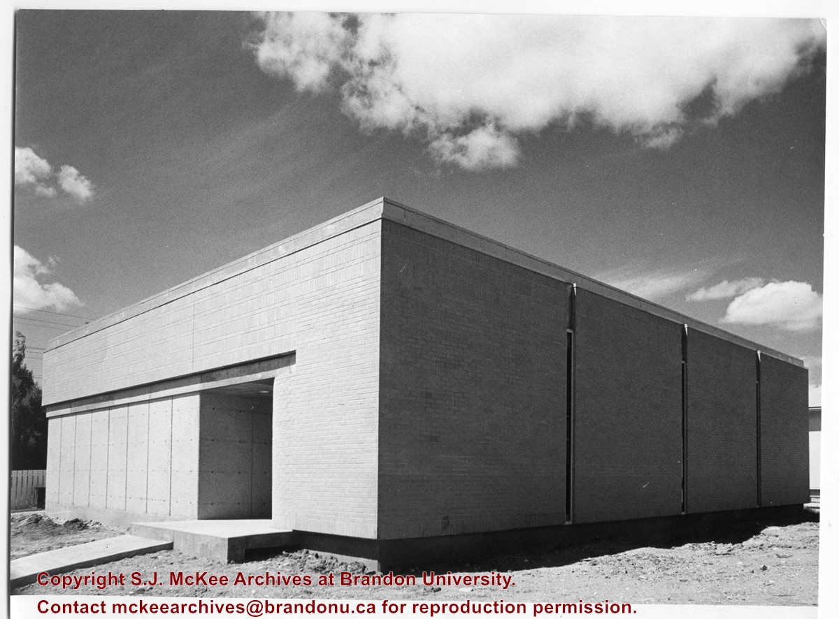
Brandon College looking south from 19th Street. Photograph was taken after Flora Cowan Hall was built but before construction of the Education Building.
Subject Access
aerial photographs
campus photographs
campus buildings
Brandon streets
Images
Show Less

Aerial view - Brandon College looking southwest

http://archives.brandonu.ca/en/permalink/descriptions601
Part Of
Brandon University Photograph collection
Description Level
Item
GMD
graphic
Date Range
[1963-1966]
Part Of
Brandon University Photograph collection
Description Level
Item
Series Number
2.1
Item Number
BUPC 2.1.8
GMD
graphic
Date Range
[1963-1966]
Physical Description
5" x 4" (b/w)
Scope and Content
Image shows the Brandon College campus from 17th Street looking southwest. The photo was taken after the completion of the original Music Building in 1963, but construction of the Education Building. Also visible are a number of properties on the 200 block of 18th Street and the 200 block of 20th Street.
Subject Access
aerial photographs
campus photographs
campus buildings
Brandon streets
Images
Show Less

Aerial view: Brandon College from 23rd Street

http://archives.brandonu.ca/en/permalink/descriptions602
Part Of
Brandon University Photograph collection
Description Level
Item
GMD
graphic
Date Range
[1963-1966]
Part Of
Brandon University Photograph collection
Description Level
Item
Series Number
2.1
Item Number
BUPC 2.1.9
GMD
graphic
Date Range
[1963-1966]
Physical Description
5" x 4" (b/w)
Scope and Content
Image is looking east northeast from approximately the 300 block of 23rd Street between Lorne and Louise Avenues. Photograph shows the Brandon College campus after the opening of the original Music Building in 1963, but before the construction of the Education Building in 1966. A number of house on the 300 blocks of 22nd and 21st Streets are visible in the foreground, with the A.E. McKenzie Seed Co., the Prince Edward Hotel and various grain elevators on the horizon.
Subject Access
aerial photographs
campus photographs
campus buildings
Brandon streets
Grain elevators
Images
Show Less

Site Services Building

http://archives.brandonu.ca/en/permalink/descriptions710
Part Of
Brandon University Photograph Collection
Description Level
Item
GMD
graphic
Date Range
[197-]
Part Of
Brandon University Photograph Collection
Description Level
Item
Series Number
2.12
Item Number
BUPC 2.12.5
GMD
graphic
Date Range
[197-]
Physical Description
8" x 10" (b/w)
History / Biographical
The Site Services building was built in 1971.
Scope and Content
Photograph is looking northwest and shows the exterior of the Site Services Building located on at 20th Street and Louise Avenue.
Images
Show Less

British American dealers - aerial view looking north at intersection of Highways 1 and 10

http://archives.brandonu.ca/en/permalink/descriptions11240
Part Of
CKX fonds
Description Level
Item
GMD
graphic
Date Range
after 1954
Accession Number
11-2010
Part Of
CKX fonds
Creator
CKX
Description Level
Item
Item Number
11-2010.B3u
Accession Number
11-2010
GMD
graphic
Date Range
after 1954
Physical Description
5" x 4" (b/w)
Material Details
Negative
Custodial History
See fonds level of the CKX records for custodial history.
Scope and Content
Image consists of an aerial view looking north at the intersection of Highways 1 and 10 and shows the British American dealer located at the intersection.
Name Access
CKX
British American Dealers
Brandon, Manitoba
Subject Access
aerial photographs
Storage Location
CKX fonds - 2010 accessions
Images
Show Less

British American dealers - aerial view looking southeast from intersection of Highways 1 and 10

http://archives.brandonu.ca/en/permalink/descriptions11242
Part Of
CKX fonds
Description Level
Item
GMD
graphic
Date Range
after 1954
Accession Number
11-2010
Part Of
CKX fonds
Creator
CKX
Description Level
Item
Item Number
11-2010.B3v
Accession Number
11-2010
GMD
graphic
Date Range
after 1954
Physical Description
5" x 4" (b/w)
Material Details
Negative
Custodial History
See fonds level of the CKX records for custodial history.
Scope and Content
Image consists of an aerial view looking southeast at the intersection of Highways 1 and 10 and shows the British American dealer located at the intersection.
Name Access
CKX
British American Dealers
Brandon, Manitoba
Subject Access
aerial photographs
Storage Location
CKX fonds - 2010 accessions
Images
Show Less

British American dealers - aerial view looking northeast from intersection of Highways 1 and 10

http://archives.brandonu.ca/en/permalink/descriptions11243
Part Of
CKX fonds
Description Level
Item
GMD
graphic
Date Range
after 1954
Accession Number
11-2010
Part Of
CKX fonds
Creator
CKX
Description Level
Item
Item Number
11-2010.B3w
Accession Number
11-2010
GMD
graphic
Date Range
after 1954
Physical Description
5" x 4" (b/w)
Material Details
Negative
Custodial History
See fonds level of the CKX records for custodial history.
Scope and Content
Image consists of an aerial view looking northeast at the intersection of Highways 1 and 10 and shows the British American dealer located at the intersection.
Name Access
CKX
British American Dealers
Brandon, Manitoba
Subject Access
aerial photographs
Storage Location
CKX fonds - 2010 accessions
Images
Show Less
Part Of
CKX fonds
Description Level
Item
GMD
graphic
Date Range
after 1954
Accession Number
11-2010
Part Of
CKX fonds
Creator
CKX
Description Level
Item
Item Number
11-2010.B43
Accession Number
11-2010
GMD
graphic
Date Range
after 1954
Physical Description
5" x 4" (b/w)
Material Details
Negative
Custodial History
See fonds level of the CKX records for custodial history.
Scope and Content
Image consists of a picture of G. Box.
Name Access
CKX Television
G. Box
Subject Access
portraits
photographs
Storage Location
CKX fonds - 2010 accessions
Images
Show Less
Part Of
RG 7 Beverley Nicholson fonds
Description Level
Sub-series
GMD
multiple media
Date Range
2003-2008
Accession Number
1-2010
Part Of
RG 7 Beverley Nicholson fonds
Description Level
Sub-series
Series Number
1.1
Accession Number
1-2010
GMD
multiple media
Date Range
2003-2008
History / Biographical
The high biodiversity and evidence of pre-Europeon contact prompted the decision to test the Crepeele locale. The survey was named in recognition of the Casselman family, the original landowners. 
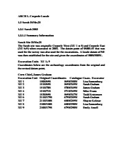
Archaeological testing began in the Crepeele locale in May 2003 on property now owned by the Crepeele family. The locale covers over 6 sections or approximately 3,800 acres of land in an area of stabilized sand dunes and wetlands covered with mixed forest and prairie grass. Given the terrain, the size of the crew and time constrains, an area of approximately 60 acres was chosen for the survey. The survey used the established archaeological methodology of walking the selected area and using a shovel test surveyed grid. The use of GIS technology to locate the exact test spot and record the information into a GIS database was a significant advance and was one of the advantages of the integration of multi-disciplinary techniques encouraged by the SCAPE project. Over one half of the test pits resulted in the recovery of cultural materials. The results of the Casselman survey indicated several areas for further examination including areas that became the Crepeele, Sarah and Graham sites.
Scope and Content
Sub sub series has been divided into five sub sub sub series including: (1) Summary information; (2) Field journals; (3) Site records; (4) Artifact catalogues; and (5) Photographs.
Name Access
Casselman survey
Subject Access
Archaeology Crepeele locale Casselman survey
Show Less

Crepeele site 2003

http://archives.brandonu.ca/en/permalink/descriptions11707
Part Of
RG 7 Beverley Nicholson fonds
Description Level
Sub sub series
GMD
multiple media
Date Range
2003
Accession Number
1-2010
Part Of
RG 7 Beverley Nicholson fonds
Description Level
Sub sub series
Series Number
1.2.1
Accession Number
1-2010
GMD
multiple media
Date Range
2003
Material Details
Field journals have been scanned in multi-page PDF files. Artifact catalogues are PDF files in spreadsheet format. Photographs are in jpeg format.
History / Biographical
The Crepeele site was identified from the results of the Casselman survey. The site is located within the Crepeele locale approximately 400 meters to the west of the Sarah site. The units were excavated by Crew Chief James Graham and the crew from the survey. The Crepeele site was excavated in 2003 as Crepeele 3 with the units numbered as units 10, 11, 12 & 13. These numbers have been changed on the catalogue to XU 110 – 113, due to duplication in 2005. Corresponding documents have been changed but there may be some reference to the initial numbers in the field journals. The artifacts recovered from these four excavations are faunal (animal bone), mainly bison, lithic materials (stone tools and flakes) and some ceramic (pottery). The artifact catalogue has over 600 records.
Scope and Content
Sub-sub-sub series contains: Summary information of field methology, number and co-ordinates of excavations, personnel and their staff position; Field journalsare daily records of recoveries, features and activities at the site; Site records include excavation level and unit summaries, feature sheets, profiles; sample records and maps; Artifact catalogues are lists and identifications of all artifacts recovered; Photographs are of excavation units, features, the landscape and personnel.
Name Access
Crepeele site 2003
Subject Access
Archaeology Crepeele locale Crepeele site DiMe-29 Crepeele site 2003
Show Less

Crepeele site 2003 - photographs

http://archives.brandonu.ca/en/permalink/descriptions11714
Part Of
RG 7 Beverley Nicholson fonds
Description Level
sub sub sub series
GMD
graphic
Date Range
2003
Accession Number
1-2010
Part Of
RG 7 Beverley Nicholson fonds
Description Level
sub sub sub series
Series Number
1.2.1.5
Accession Number
1-2010
GMD
graphic
Date Range
2003
Physical Description
5 photographs
Material Details
JPEGs
History / Biographical
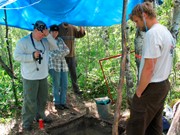
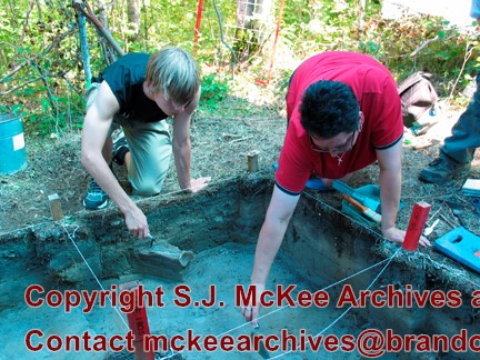
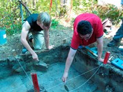
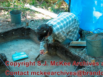
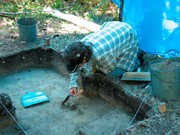
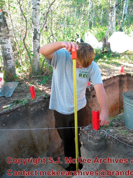
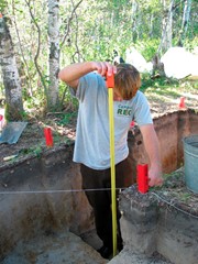
Numerous photographs were taken during the excavation of the Crepeele site 2003. A selection of photographs of personnel performing usual field tasks such as surveying, measuring, excavating, and taking photographs were selected for the archive.
Scope and Content
Sub sub sub series consists of photographs taken during excavation of the Crepeele site 2003.
Name Access
Crepeele site 2003 - photographs
Subject Access
Archaeology Crepeele locale Crepeele site DiMe-29 Crepeele site 2003
Show Less

Crepeele site 2003 - site records

http://archives.brandonu.ca/en/permalink/descriptions11715
Part Of
RG 7 Beverley Nicholson fonds
Description Level
sub sub sub series
GMD
multiple media
Date Range
2003
Accession Number
1-2010
Part Of
RG 7 Beverley Nicholson fonds
Description Level
sub sub sub series
Series Number
1.2.1.3
Accession Number
1-2010
GMD
multiple media
Date Range
2003
Material Details
Site records have been scanned in multi-page PDF files.
History / Biographical
The Crepeele site was excavated in 2003 as Crepeele 3. Standard archaeological methods were used to excavate the units. Site records of excavation units XU 110 – 113 are in seperate pdf files.
Scope and Content
Site records of excavation units may include: level summaries, floor plans, feature sheets, wall profiles, unit summaries and any other additional information relating to the unit.
Name Access
Crepeele site 2003 - site records
Subject Access
Archaeology Crepeele locale Crepeele site DiMe-29 Crepeele site 2003
Show Less

Crepeele site 2003 - Sarah Graham, Todd Kristensen and crew photographing.

http://archives.brandonu.ca/en/permalink/descriptions11716
Part Of
RG 7 Beverley Nicholson fonds
Description Level
Item
GMD
graphic
Date Range
2003
Accession Number
1-2010
Part Of
RG 7 Beverley Nicholson fonds
Description Level
Item
Series Number
1.2.1.5
Item Number
1.2.1.5.4
Accession Number
1-2010
GMD
graphic
Date Range
2003
Physical Description
432x324 (195 KB )
Material Details
JPEG
Scope and Content
Sarah Graham, Todd Kristensen and crew photographing.
Name Access
Crepeele site 2003 - Sarah Graham, Todd Kristensen and crew photographing
Subject Access
Archaeology Crepeele locale Crepeele site DiMe-29 Crepeele site 2003 Crepeele site 2003 - photographs
Images
Show Less

Crepeele site 2003 - Bonnie Alston and student excavating

http://archives.brandonu.ca/en/permalink/descriptions11717
Part Of
RG 7 Beverley Nicholson fonds
Description Level
Item
GMD
graphic
Date Range
2003
Accession Number
1-2010
Part Of
RG 7 Beverley Nicholson fonds
Description Level
Item
Series Number
1.2.1.5
Item Number
1.2.1.5.5
Accession Number
1-2010
GMD
graphic
Date Range
2003
Physical Description
432x324 (200 KB )
Material Details
JPEG
Scope and Content
Bonnie Alston and student excavating.
Name Access
Crepeele site 2003 - Bonnie Alston
Subject Access
Archaeology Crepeele locale Crepeele site DiMe-29 Crepeele site 2003 Crepeele site 2003 - photographs
Images
Show Less

Crepeele site 2003 - Emily Ansell excavating

http://archives.brandonu.ca/en/permalink/descriptions11718
Part Of
RG 7 Beverley Nicholson fonds
Description Level
Item
GMD
graphic
Date Range
2003
Accession Number
1-2010
Part Of
RG 7 Beverley Nicholson fonds
Description Level
Item
Series Number
1.2.1.5
Item Number
1.2.1.5.2
Accession Number
1-2010
GMD
graphic
Date Range
2003
Physical Description
432x324 (183KB )
Material Details
JPEG
Scope and Content
Emily Ansell excavating at the Crepeele site 2003.
Name Access
Crepeele site 2003 - Emily Ansell excavating
Subject Access
Archaeology Crepeele locale Crepeele site DiMe-29 Crepeele site 2003 - photographs
Images
Show Less

Crepeele site 2003 - Todd Kristensen measuring

http://archives.brandonu.ca/en/permalink/descriptions11719
Part Of
RG 7 Beverley Nicholson fonds
Description Level
Item
GMD
graphic
Date Range
2003
Accession Number
1-2010
Part Of
RG 7 Beverley Nicholson fonds
Description Level
Item
Series Number
1.2.1.5
Item Number
1.2.1.5.3
Accession Number
1-2010
GMD
graphic
Date Range
2003
Physical Description
432x576 (195 KB )
Material Details
JPEG
Scope and Content
Todd Kristensen measuring at the Crepeele site.
Name Access
Crepeele site 2003 - Todd Kristensen measuring
Subject Access
Archaeology Crepeele locale Crepeele site DiMe-29 Crepeele site 2003 Crepeele site 2003 - photographs
Images
Show Less

Sarah site 2003 - summary information

http://archives.brandonu.ca/en/permalink/descriptions11720
Part Of
RG 7 Beverley Nicholson fonds
Description Level
sub sub sub series
GMD
multiple media
Date Range
2003
Accession Number
1-2010
{add= ARCH 1. Crepeele Locale 1.3 Sarah DiMe-28 1.3.1 Sarah 2003 1.3.1.1 Summary
Part Of
RG 7 Beverley Nicholson fonds
Description Level
sub sub sub series
Series Number
1.3.1.1
Accession Number
1-2010
GMD
multiple media
Date Range
2003
Material Details
Field journals have been scanned in multi-page PDF files. Artifact catalogues are PDF files in spreadsheet format. Photographs are in jpeg format.
History / Biographical
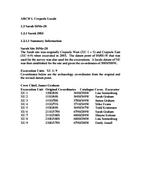
The Sarah site was initially chosen for excavation based on the results of the Casselman survey. The survey recovered significant amounts of faunal remains, some ceramics and lithics from the test pits. Excavations took place in 2003 at Crepeele West (Units 1-5) and Crepeele East (Units 6-9). The site was subsequently renamed the Sarah site DiMe-28. Units 1 to 9 were excavated by supervisor James Graham and crew of Sarah Graham, Mike Evans, Todd Kristensen, Shayne Kolesar, Lisa Sonnenburg and Emily Ansell.
Scope and Content
Sub-sub-sub series contains: Summary information of field methology, number and co-ordinates of excavations, personnel and their staff position.
Name Access
Sarah site 2003 - summary information
Subject Access
Archaeology Crepeele locale Sarah site DiMe-28 Sarah site 2003
Documents

1.3.1.1_ Sarah03_summary.pdf

Read PDF Download PDF
Show Less

Casselman survey - summary information

http://archives.brandonu.ca/en/permalink/descriptions11724
Part Of
RG 7 Beverley Nicholson fonds
Description Level
Sub sub series
GMD
multiple media
Date Range
2003
Part Of
RG 7 Beverley Nicholson fonds
Description Level
Sub sub series
Series Number
1.1.1
GMD
multiple media
Date Range
2003
Material Details
Field journals have been scanned in multi-page PDF files. Artifact catalogues are PDF files in spreadsheet format. Photographs are in jpeg format.
History / Biographical
Archaeological testing began in the Crepeele locale in May 2003 with a field crew of four members. James Graham supervised the crew and was assisted by Sarah Graham, Jollana Bishop, and Lisa Sonnenburg. Later additions to the testing team were Todd Kristensen, Michael Evans, and Emily Ansell. The methodology for this survey used an arbitrary datum and a transit to establish a grid of 30 m intervals and a shovel test every 20 m. Materials were removed and screened to a minimum depth of 50 cm below surface. All recovered materials were bagged and removed to the lab for further analysis. All information including: test pit grid co-ordinates; UTM co-ordinates for each test pit; artifact presence; excavator; vegetation; aspect; paleosol; paleosol depth; and notes, were entered into a GIS database. Approximately 600 shovel test pits were excavated and recorded in this fashion. Of the 600 shovel test pits, over 300 contained cultural materials. Based on the results of the Casselman survey several areas were designed for further testing and excavation. Crepeele West and Crepeele East were renamed the Sarah site DiMe-28) and Crepeele 3 which became the Crepeele site DiMe- 29.
Scope and Content
Sub-sub-sub series contains: Summary information of field methology, number and co-ordinates of excavations, personnel and their staff position; Field journalsare daily records of recoveries, features and activities at the site; Site records include excavation level and unit summaries, feature sheets, profiles; sample records and maps; Artifact catalogues are lists and identifications of all artifacts recovered; Photographs are of excavation units, features, the landscape and personnel.
Name Access
Casselman survey - summary information
Subject Access
Archaeology Crepeele locale Casselman survey Casselman survey - summary information
Show Less

Crepeele site 2004

http://archives.brandonu.ca/en/permalink/descriptions11725
Part Of
RG 7 Beverley Nicholson fonds
Description Level
Sub sub series
GMD
multiple media
Date Range
2004
Accession Number
1-2010
Part Of
RG 7 Beverley Nicholson fonds
Description Level
Sub sub series
Series Number
1.2.2
Accession Number
1-2010
GMD
multiple media
Date Range
2004
Material Details
Field journals have been scanned in multi-page PDF files. Artifact catalogues are PDF files in spreadsheet format. Photographs are in jpeg format.
History / Biographical
The Crepeele site was identified from the results of the Casselman survey and excavated in 2003. In 2004 the site was funded through the SCAPE project, directed by Bev Nicholson. The units were excavated by Crew Chief Tomasin Playford and crew. Eight units were excavated in 2004, XU 1to XU 8 The artifacts recovered from these eight excavations are faunal (animal bone), mainly bison, lithic materials (stone tools and flakes) and some ceramic (pottery). The artifact catalogue has 1258 records.
Scope and Content
Sub-sub-sub series contains: Summary information of field methology, number and co-ordinates of excavations, personnel and their staff position; Field journalsare daily records of recoveries, features and activities at the site; Site records include excavation level and unit summaries, feature sheets, profiles; sample records and maps; Artifact catalogues are lists and identifications of all artifacts recovered; Photographs are of excavation units, features, the landscape and personnel.
Name Access
Crepeele site 2004
Subject Access
Archaeology Crepeele locale Crepeele site DiMe-29 Crepeele site 2004
Show Less

20 records – page 1 of 1.