View is southwest from approximatley 16th Street between Princess and Rosser Avenues. Photograph shows the Brandon University campus, as well as surrounding residential blocks, including Flemming, J.R. Reid and Vincent Massey schools.
View is west southwest from approximatley 16th Street between Princess and Lorne Avenues. Photograph shows the Brandon University campus, as well as surrounding residential blocks between 16th and 23rd Streets, Princess and Louise Avenues..
View is west from approximatley 17th Street between Lorne and Louise Avenues. Photograph shows a portion of the Brandon University campus (excluding the Education Building and anything north of it), as well as surrounding residential blocks from approximatley 17th Street to 22nd Street.
View is west northwest from approximatley 16th Street and Louise Avenue. Photograph shows the Brandon University campus, prior to the Library Extension, and a large portion of the city to the west of the campus.
View is northwest from approximatley 16th Street and Louise Avenue. Photograph shows the Brandon University campus, prior to the Library Extension, and a large portion of the city to the west of the campus.
Photograph shows the removal of one of the houses formerly located on 20th Street between Louise and Princess Avenues. The houses on those blocks were removed to create parking lots for the University. A Fed Zavislak Ltd. Well Drilling & Trucking pickup truck is visible at the curb.
Photograph shows the removal of one of the houses formerly located on 20th Street between Louise and Princess Avenues. The houses on those blocks were removed to create parking lots for the University.
View is northeast probably from the roof of McMaster Hall. Photograph shows the construction of the new roof on Clark Hall and the Brandon College Building. A portion of the east side of the 000 and 100 blocks of 18th Street, as well as the corner of 18th Street and Rosser Avenue are visible in the upper left hand corner. This includes the "Downtown Brandon" sign.
View is north northeast probably from the roof of McMaster Hall. Photograph shows the construction of the new roof on Clark Hall and the Brandon College Building, as well as the construction of the extension to Clark Hall and the skywalk. Portions of the city as far north as the Assiniboine River are also visible.
View is northeast from the Brandon College Building. Photograph shows the inside of the Brandon College Building after it had been gutted and then partially rebuilt. The exterior fascade of the west side of the building can be clearly seen in this photograph. A number of houses on the east side of 200 block of 18th Street are also visible, as is the stone fence on Princess Avenue and the flag pole on the front lawn.
View is north northeast from the roof of McMaster Hall. Photograph shows the campus under construction during the renovation of the Brandon College Building and Clark Hall. The photograph was taken in late fall after the roof had been removed from the buildings but before the construction of the extension of Clark Hall. Construction materials litter the courtyard and driveway. The view looking north extends to The North Hill - a number of residential blocks, particularly to the northeast of 18th Street are visible. Buildings include the International Harvester Building and Kin Village.
View is north northeast probably from the roof of McMaster Hall. Photograph shows the construction of the new roof on Clark Hall and the Brandon College Building, as well as the construction of the extension to Clark Hall and the skywalk. The view looking north extends to The North Hill - a number of residential blocks, particularly to the northeast of 18th Street are visible. Buildings include the International Harvester Building and Kin Village.
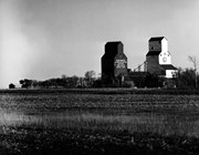
Stuckey's notes: Elevator on right moved to Nesbitt. Other scrapped. Wawanesa spur (remainder of CN Belmont branch) closed end 1982 crop year, summer 1983. Mainline Modeller, Oct. 1982.
Scope and Content
Photograph shows two grain elevators.
Notes
Corresponds with negative RA - CNR Wawanesa Sub [182b].
Repro Restriction
The McKee Archives is the copyright holder for the Stuckey materials.
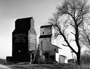
Stuckey's notes: Elevator on right moved to Nesbitt. Other scrapped. Wawanesa spur (remainder of CN Belmont branch) closed end 1982 crop year, summer 1983. Mainline Modeller, Oct. 1982.
Scope and Content
Photograph shows two grain elevators.
Notes
Corresponds with negative RA - CNR Wawanesa Sub [182a].
Repro Restriction
The McKee Archives is the copyright holder for the Stuckey materials.
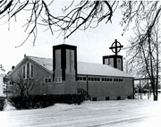
The Anglican Church first became active in Virden in 1882. At that time services were held in the home of one of the parishioners. In August of 1885, the Canadian North West Land Company gave the Anglican community a parcel of land at the corner of Ninth Avenue and Queen Street. In December of 1885, a wood frame Church was constructed on the property. The parish of St. Mary the Virgin was officially created on April 20, 1886
The original church remained on the site until 1891, at which time it was sold and removed. The present church was then constructed on the site using field stones from the Assiniboine River valley. The stones were hauled to the site, split and put in position.. Construction began in 1892, with the corner stone being laid by Mrs. Nina Gertrude Watts, wife of the rector. A tin box containing newspapers, building plans and other items was also placed in the foundation at that time.
It is believed that the building's architect, Walter Chesterson of Winnipeg, designed St. Mary's from a small church located on the Isle of Wight.. The resulting structure is a basilica styled Church with a large stone tower at the south east corner, numerous stained glass windows and beautiful woodwork throughout.
It took some years to completely pay off the debt incurred in building, but the congregation persisted and as a result, the church was consecrated in 1905 by the Archbishop of Rupert's Land, the Right Reverend Samuel Prichard Matheson.
Since then, there have been additions built onto the original building, but during each expansion, great care was taken to preserve the look and feel of the original building. Included in these expansions were a fieldstone fence, the addition of a clostier and a entension of the roof to protect the sidewalk. The last major work done was upgrading the foundation under the tower. This was finished in the late 1970's.
The church is located at 633 9th Avenue South.
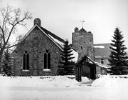
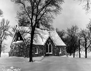
Scope and Content
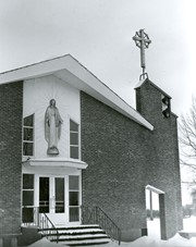
Photograph shows the church and manse.
Notes
Corresponds with negative RA - CPR Broadview Sub [41a]. There is a common misconception that this house was the Anglican manse. Although it was built around the same time, it was never owned by the church and was always a private residence. (Source: Natalie Griffith, Virden resident). History/Bio information taken from the St. Mary's Anglican Church history page on the Community of Virden website, available at: http://virden.cimnet.ca/cim/187C2_3T178T4T628T5T1176.dhtm (August 7, 2008).
Repro Restriction
The McKee Archives is the copyright holder for the Stuckey materials.
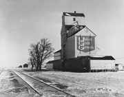
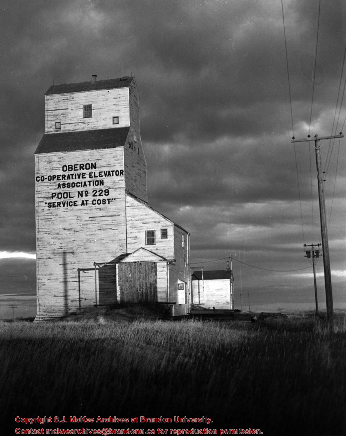
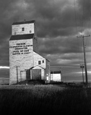
Photograph shows the grain elevator at Oberon, MB. Writing on the building reads: Oberon Co-operative Elevator Association, Pool No. 229 "Service at Cost."
Notes
Corresponds with negative RA - CPR North [27.1a]
Repro Restriction
The McKee Archives is the copyright holder for the Stuckey materials.


