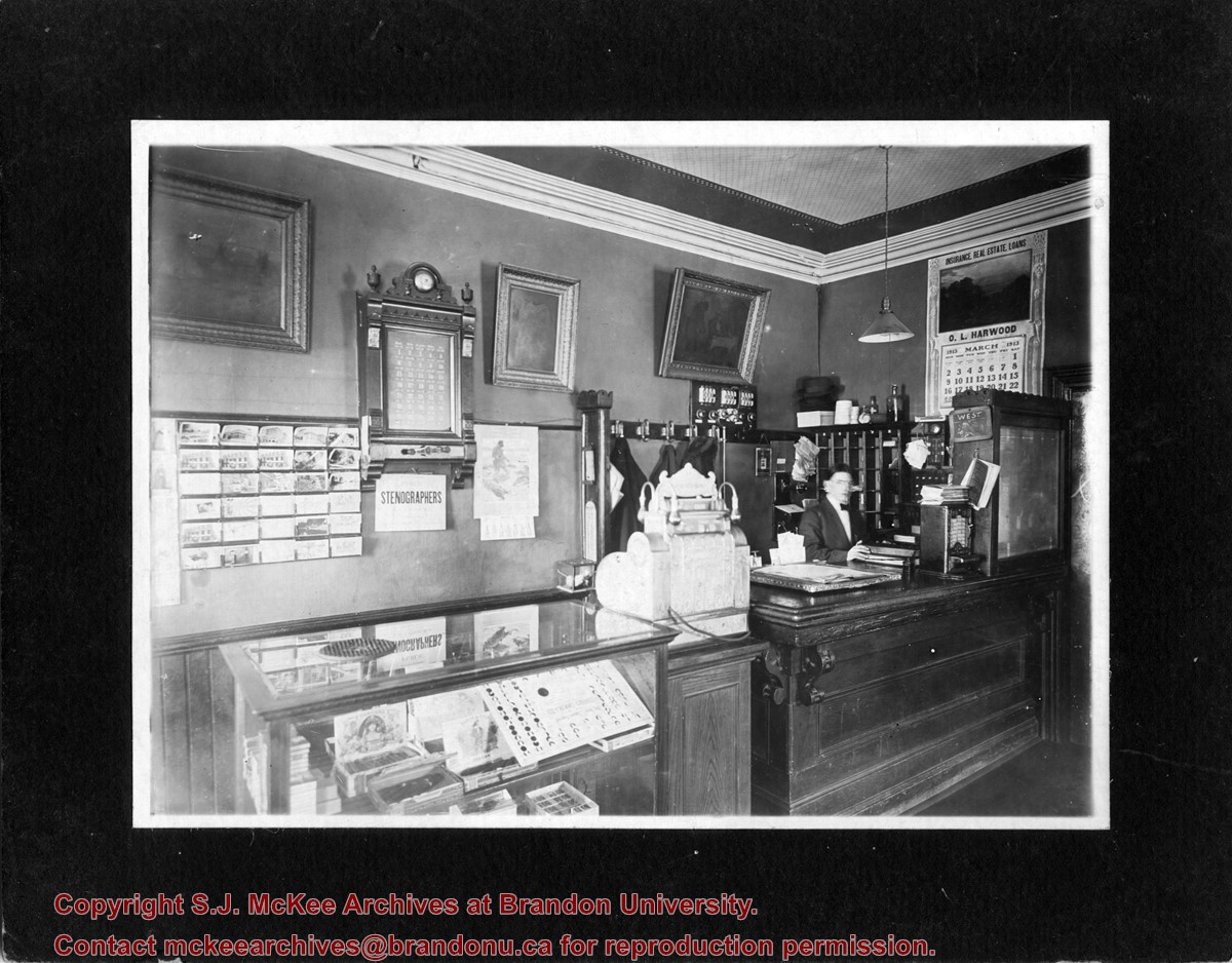
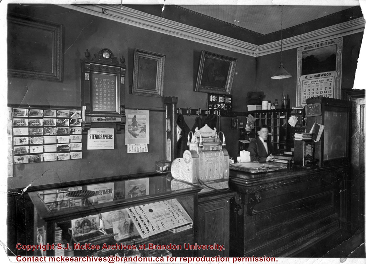
Photograph shows the possible interior of the Grandview Hotel. A young man is working behind the counter that holds a cash register and tobacco display case. A calendar for March 1913 advertises O.L. Harwood's Insurance, Real Estate, and Loans. Below the hotel's 35-room call box is an advertisement for the Public Stenographers Company. A postcard stand holds cards of Brandon's courthouse and other prominent buildings.
Photograph shows the possible interior of the Grandview Hotel. A young man is working behind the counter that holds a cash register and tobacco display case. A calendar for March 1913 advertises O.L. Harwood's Insurance, Real Estate, and Loans. Below the hotel's 35-room call box is an advertisement for the Public Stenographers Company. A postcard stand holds cards of Brandon's courthouse and other prominent buildings.
Notes
Date ascertained from calendar above counter. This photograph is a duplicate of 20-2009.23 but is in sharper focus. Grand View is written in pencil on the back of the photograph.
Photograph shows a view from the rooftop of the Prince Edward Hotel. The south side of the Brandon Hotel (most recently the Brandon Inn) and a service station along Prince Avenue can be seen.
Notes
Writing on the back of photograph reads: across the street from roof of P.E. Hotel 1927
Postcard shows an aerial view of the city of Brandon
Notes
Writing on the back of the postcard reads: No. 10. Brandon, Manitoba, Canada / Aerial View of Brandon / Distributed by Clements Drug Store / Brandon, Manitoba, Canada / Photos by: R.J. "Bob" Snazel. / Printed by: D.W. Friesen & Sons Ltd. Altona, Manitoba, Canada. The postcard is addressed to Mr. F.A. Rosser and is postmarked Brandon 30 May 1970. A 6-cent Queen Elizabeth red postage stamp portraying various modes of the transportation. The stamp has been cancelled with a postmark that reads "Help Retarded Children."
Photograph shows the construction of the McGuinness home in a new housing development in Medicine Hat, 492 6th Street Northeast. Aerial view shows that neighbouring blocks have yet to be constructed.
Photograph shows the McGuinness home in a new housing development in Medicine Hat, 492 6th Street Northeast. Aerial view shows that neighbouring blocks have yet to be constructed and the backyard to the McGuinness home is completed.
A typed label has been taped to the back of the photograph. No other degredation observed. ST/2016
Custodial History
Photograph sent to Fred McGuinness from the Winnipeg Free Press Photo Department
Scope and Content
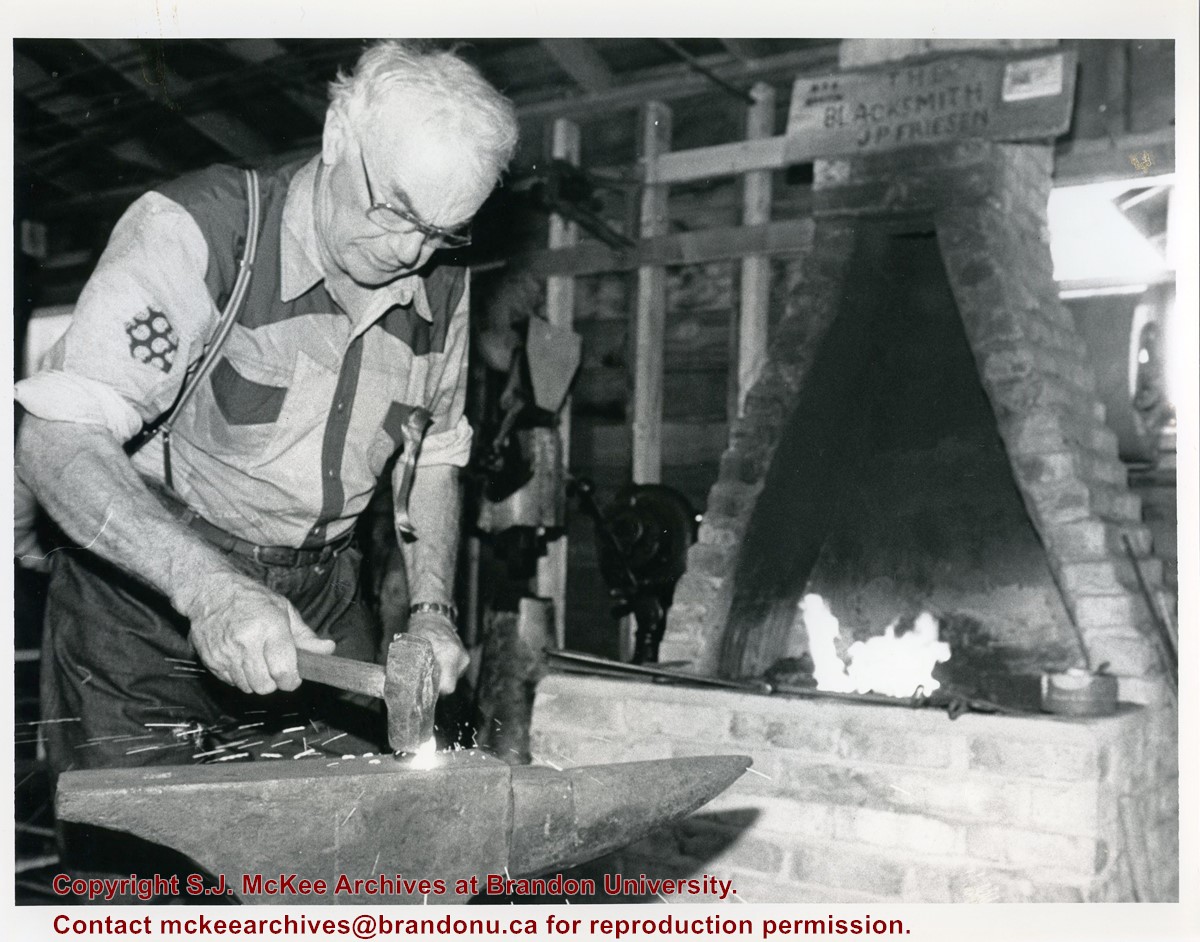
Photograph shows an elderly man hammering on an anvil in a Blacksmith's shop. A wooden sign on the chimney above the fire reads: The Blacksmith JP Friesen.
Notes
Photograph was collected during the research phase of the monograph "Manitoba: The Province & The People" (1987) written by Fred McGuinness and Ken Coates.
Writing on the back of the photograph reads: Blacksmith John Peter Friesen of Grunthal flattens a piece of iron fresh out of the forge at the Thresherman's [sic.] Reunion in Austin Thursday. July 24/86 dirk.
View is southwest from approximately Princess Avenue and 17th Street. Photograph shows the Brandon University campus in fall, as well as the southwest portion of the city.
View is south southwest from approximatley the east corner of 18th Street and Princess Avenue. Photograph shows the Brandon University campus, Kinsmen Stadium, Earl Oxford school and a number of residential blocks, particularly southwest of 18th Street.
View is southeast from approximatley 23rd Street and Rosser Avenue. Photograph shows the Brandon University campus, Kinsmen Stadium, Earl Oxford school, the Fair Grounds (including the Grandstand and Racetrack) and a number of residential blocks, particularly in the southeast part of the city.
View is west from 17th Street between Louise and Princess Avenues. Photograph shows the Brandon University Campus, Fleming School and Coronation Park, as well as a number of residential blocks.
View is south southeast from approsimatley Rosser Avenue and 21st Street. Photograph shows the Brandon University campus, Kinsmen Stadium, Earl Oxford School, the Fair Grounds (including the Grand Stand and Race Track), and a number of residential blocks.
View is south southwest from approximatley the southwest corner of 18th Street and Princess Avenue. Photograph shows the University campus, Kinsmen Stadium, Earl Oxford School and residential blocks.
View is west from 17th Street between Louise and Princess Avenues to approximalety 25th Street. Photograph shows the University campus, Fleming School, Coronation Park and residential blocks.
A problem during development has obscured a portion of Kinsmen Stadium and the southeast corner of the campus.
Scope and Content
View is north from Victoria Avenue between 18th and 20th Streets to the railway tracks. Photograph shows Kinsmen Stadium, the College campus and a number of residential blocks.
View is northeast from approximately the southwest corner of Victoria Avenue and 22nd Street to the Assiniboine River near 1st Street. Photograph shows the College campus, Kinsmen Stadium, residential blocks, downtown and the railway tracks.


