Skip header and navigation

Revise Search

20 records – page 1 of 1.

Aerial view - Brandon University campus

http://archives.brandonu.ca/en/permalink/descriptions7989
Part Of
Brandon University Photograph collection
Description Level
Item
GMD
graphic
Date Range
c. 2000
Part Of
Brandon University Photograph collection
Creator
Photograph commissioned by Brandon University and taken by Yourview Aerial Scenics Ltd.
Description Level
Item
Series Number
2.1
Item Number
BUPC 2.1.55
GMD
graphic
Date Range
c. 2000
Physical Description
6" x 4" (colour)
Scope and Content
View is southwest from approximatley 16th Street between Princess and Rosser Avenues. Photograph shows the Brandon University campus, as well as surrounding residential blocks, including Flemming, J.R. Reid and Vincent Massey schools.
Subject Access
aerial photographs
campus photographs
campus buildings
Brandon streets
Images
Show Less

Aerial view - Brandon University campus

http://archives.brandonu.ca/en/permalink/descriptions7990
Part Of
Brandon University Photograph collection
Description Level
Item
GMD
graphic
Date Range
c. 2000
Part Of
Brandon University Photograph collection
Creator
Photograph commissioned by Brandon University and taken by Yourview Aerial Scenics Ltd.
Description Level
Item
Series Number
2.1
Item Number
BUPC 2.1.56
GMD
graphic
Date Range
c. 2000
Physical Description
6" x 4" (colour)
Scope and Content
View is west southwest from approximatley 16th Street between Princess and Lorne Avenues. Photograph shows the Brandon University campus, as well as surrounding residential blocks between 16th and 23rd Streets, Princess and Louise Avenues..
Subject Access
aerial photographs
campus photographs
campus buildings
Brandon streets
Images
Show Less

Aerial view - Brandon University campus

http://archives.brandonu.ca/en/permalink/descriptions7991
Part Of
Brandon University Photograph collection
Description Level
Item
GMD
graphic
Date Range
c. 2000
Part Of
Brandon University Photograph collection
Creator
Photograph commissioned by Brandon University and taken by Yourview Aerial Scenics Ltd.
Description Level
Item
Series Number
2.1
Item Number
BUPC 2.1.57
GMD
graphic
Date Range
c. 2000
Physical Description
6" x 4" (colour)
Scope and Content
View is west from approximatley 17th Street between Lorne and Louise Avenues. Photograph shows a portion of the Brandon University campus (excluding the Education Building and anything north of it), as well as surrounding residential blocks from approximatley 17th Street to 22nd Street.
Subject Access
aerial photographs
campus photographs
campus buildings
Brandon streets
Images
Show Less

Aerial view - Brandon University campus

http://archives.brandonu.ca/en/permalink/descriptions7992
Part Of
Brandon University Photograph collection
Description Level
Item
GMD
graphic
Date Range
c. 1990
Part Of
Brandon University Photograph collection
Description Level
Item
Series Number
2.1
Item Number
BUPC 2.1.58
GMD
graphic
Date Range
c. 1990
Physical Description
5" x 3.5" (colour)
Scope and Content
View is west northwest from approximatley 16th Street and Louise Avenue. Photograph shows the Brandon University campus, prior to the Library Extension, and a large portion of the city to the west of the campus.
Subject Access
aerial photographs
campus photographs
campus buildings
Brandon streets
Images
Show Less

Aerial view - Brandon University campus

http://archives.brandonu.ca/en/permalink/descriptions7993
Part Of
Brandon University Photograph collection
Description Level
Item
GMD
graphic
Date Range
c. 1990
Part Of
Brandon University Photograph collection
Description Level
Item
Series Number
2.1
Item Number
BUPC 2.1.59
GMD
graphic
Date Range
c. 1990
Physical Description
5" x 3.5" (colour)
Scope and Content
View is northwest from approximatley 16th Street and Louise Avenue. Photograph shows the Brandon University campus, prior to the Library Extension, and a large portion of the city to the west of the campus.
Subject Access
aerial photographs
campus photographs
campus buildings
Brandon streets
Show Less
Part Of
Brandon University Photograph collection
Description Level
Item
GMD
graphic
Date Range
c. 1985
Part Of
Brandon University Photograph collection
Description Level
Item
Series Number
2.1
Item Number
BUPC 2.1.60
GMD
graphic
Date Range
c. 1985
Physical Description
5" x 3.5" (colour)
Scope and Content
Photograph shows the removal of one of the houses formerly located on 20th Street between Louise and Princess Avenues. The houses on those blocks were removed to create parking lots for the University. A Fed Zavislak Ltd. Well Drilling & Trucking pickup truck is visible at the curb.
Subject Access
campus photographs
Brandon streets
Images
Show Less
Part Of
Brandon University Photograph collection
Description Level
Item
GMD
graphic
Date Range
c. 1985
Part Of
Brandon University Photograph collection
Description Level
Item
Series Number
2.1
Item Number
BUPC 2.1.61
GMD
graphic
Date Range
c. 1985
Physical Description
5" x 3.5" (colour)
Scope and Content
Photograph shows the removal of one of the houses formerly located on 20th Street between Louise and Princess Avenues. The houses on those blocks were removed to create parking lots for the University.
Subject Access
campus photographs
Brandon streets
Images
Show Less

Brandon University campus construction

http://archives.brandonu.ca/en/permalink/descriptions8005
Part Of
Brandon University Photograph collection
Description Level
Item
GMD
graphic
Date Range
c. 1996
Part Of
Brandon University Photograph collection
Creator
Photographer: Sandy Black
Description Level
Item
Series Number
2.1
Item Number
BUPC 2.1.71
GMD
graphic
Date Range
c. 1996
Physical Description
4" x 6" (colour)
Scope and Content
View is northeast probably from the roof of McMaster Hall. Photograph shows the construction of the new roof on Clark Hall and the Brandon College Building. A portion of the east side of the 000 and 100 blocks of 18th Street, as well as the corner of 18th Street and Rosser Avenue are visible in the upper left hand corner. This includes the "Downtown Brandon" sign.
Subject Access
campus photographs
campus buildings
campus construction
Brandon streets
Images
Show Less

Brandon University campus construction

http://archives.brandonu.ca/en/permalink/descriptions8006
Part Of
Brandon University Photograph collection
Description Level
Item
GMD
graphic
Date Range
c. 1996
Part Of
Brandon University Photograph collection
Creator
Photographer: Sandy Black
Description Level
Item
Series Number
2.1
Item Number
BUPC 2.1.72
GMD
graphic
Date Range
c. 1996
Physical Description
6" x 4" (colour)
Scope and Content
View is north northeast probably from the roof of McMaster Hall. Photograph shows the construction of the new roof on Clark Hall and the Brandon College Building, as well as the construction of the extension to Clark Hall and the skywalk. Portions of the city as far north as the Assiniboine River are also visible.
Subject Access
campus photographs
campus buildings
campus construction
Brandon streets
Images
Show Less

Brandon University campus construction

http://archives.brandonu.ca/en/permalink/descriptions8016
Part Of
Brandon University Photograph collection
Description Level
Item
GMD
graphic
Date Range
c. 1996
Part Of
Brandon University Photograph collection
Creator
Photographer: Sandy Black
Description Level
Item
Series Number
2.1
Item Number
BUPC 2.1.82
GMD
graphic
Date Range
c. 1996
Physical Description
4" x 6" (colour)
Scope and Content
View is northeast from the Brandon College Building. Photograph shows the inside of the Brandon College Building after it had been gutted and then partially rebuilt. The exterior fascade of the west side of the building can be clearly seen in this photograph. A number of houses on the east side of 200 block of 18th Street are also visible, as is the stone fence on Princess Avenue and the flag pole on the front lawn.
Subject Access
campus photographs
campus construction
Brandon streets
Images
Show Less

Brandon University campus construction

http://archives.brandonu.ca/en/permalink/descriptions8018
Part Of
Brandon University Photograph collection
Description Level
Item
GMD
graphic
Date Range
c. 1996
Part Of
Brandon University Photograph collection
Description Level
Item
Series Number
2.1
Item Number
BUPC 2.1.84
GMD
graphic
Date Range
c. 1996
Physical Description
6" x 4" (colour)
Scope and Content
View is north northeast from the roof of McMaster Hall. Photograph shows the campus under construction during the renovation of the Brandon College Building and Clark Hall. The photograph was taken in late fall after the roof had been removed from the buildings but before the construction of the extension of Clark Hall. Construction materials litter the courtyard and driveway. The view looking north extends to The North Hill - a number of residential blocks, particularly to the northeast of 18th Street are visible. Buildings include the International Harvester Building and Kin Village.
Subject Access
campus photographs
campus buildings
campus construction
Brandon streets
Images
Show Less

Brandon University campus construction

http://archives.brandonu.ca/en/permalink/descriptions8020
Part Of
Brandon University Photograph collection
Description Level
Item
GMD
graphic
Date Range
c. 1996
Part Of
Brandon University Photograph collection
Creator
Photographer: Sandy Black
Description Level
Item
Series Number
2.1
Item Number
BUPC 2.1.86
GMD
graphic
Date Range
c. 1996
Physical Description
6" x 4" (colour)
Scope and Content
View is north northeast probably from the roof of McMaster Hall. Photograph shows the construction of the new roof on Clark Hall and the Brandon College Building, as well as the construction of the extension to Clark Hall and the skywalk. The view looking north extends to The North Hill - a number of residential blocks, particularly to the northeast of 18th Street are visible. Buildings include the International Harvester Building and Kin Village.
Subject Access
campus photographs
campus buildings
campus construction
Brandon streets
Images
Show Less

Interior of Cafe Aagaard

http://archives.brandonu.ca/en/permalink/descriptions13732
Part Of
Fred McGuinness collection
Description Level
Item
GMD
graphic
Date Range
[1903-1923]
Accession Number
20-2009
Part Of
Fred McGuinness collection
Description Level
Item
Series Number
McG 9
Item Number
20-2009.42
Accession Number
20-2009
GMD
graphic
Date Range
[1903-1923]
Physical Description
5.5" x 3.5" (b/w)
Material Details
postcard
History / Biographical
Opened 1903. Closed 1923. Building became the Oak Theatre ca. 1930. Reopened as Towne Cinema ca. 1980 after being closed for many years. The building has since been demolished.
Scope and Content
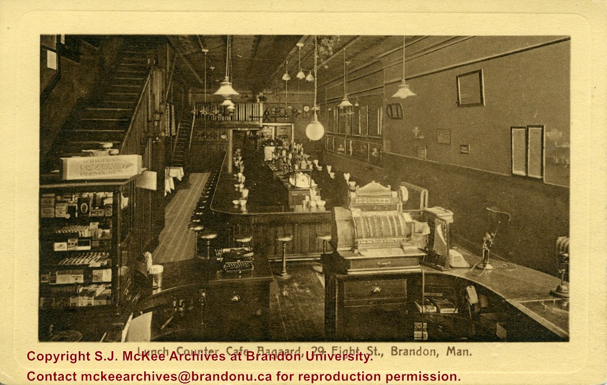
Postcard shows the interior of the lunch counter and cashier register at Cafe Aagaard located at 29-8th Street Brandon.
Notes
Writing on the front of the postcard reads: Lunch Counter Cafe Aagaard, 29 Eigth St., Brandon, Man. The back of the postcard reads: Cafe Aagaard, Largest, Oldest and Best in Brandon. The postcard is addressed to Mrs. K.L. McGregor, 157-4th St.
Name Access
Aagaard's
Cafe Aagaard
8th Street
Subject Access
restaurants
lunch counters
building interiors
store interiors
restaurant interiors
cafes
Brandon business buildings & facilities before 1940
Storage Location
RG 5 photograph storage drawer 2 (hanging photos)
Related Material
Lawrence Stuckey collection 1-2002.3.1E9
Images
Show Less

Coombs & Stewart general store c. 1881

http://archives.brandonu.ca/en/permalink/descriptions13756
Part Of
Fred McGuinness collection
Description Level
Item
GMD
graphic
Date Range
c.1881
Accession Number
20-2009
Part Of
Fred McGuinness collection
Description Level
Item
Series Number
McG 9
Item Number
20-2009.67
Accession Number
20-2009
GMD
graphic
Date Range
c.1881
Physical Description
6.5" x 5" (b/w)
Material Details
on matting
Physical Condition
Photograph is stained and water damaged. A newspaper clipping about William (Billy) Muir is glued to the top left hand corner of the mat. The image is exfoliated in the right hand corner. The negative has been reverse printed.
History / Biographical
Coombs & Stewart opened the first general store in Brandon in 1881, which was located on 6th Street and Pacific Avenue. According to G.F. Barker (Brandon: A City, 1977, 291), William (Billy) Muir worked at the store until he opened his own grocery store in 1888.
Custodial History
Donated to Fred McGuinness by Allena Strath (nee Coombs).
Scope and Content
Photograph shows the Coombs & Stewart general store located on the corner of Pacific Avenue and 6th Street. A group of men pose in front of the wood-framed store.
Notes
Back of photograph reads: One of first stores in Brandon, Coombs...[?]
Name Access
Coombs & Stewart
Pacific Avenue
6th Street
Wm. Muir General Grocer
Subject Access
Pioneers
general stores
building exteriors
store exteriors
horses
grocery stores
Brandon business buildings & facilities before 1940
Storage Location
RG 5 photograph storage drawer 2 (hanging photos)
Related Material
Lawrence Stuckey collection 1-2002.3.1E13
Images
Show Less

William Muir General Grocer building

http://archives.brandonu.ca/en/permalink/descriptions13757
Part Of
Fred McGuinness collection
Description Level
Item
GMD
graphic
Date Range
post-1888
Accession Number
20-2009
Part Of
Fred McGuinness collection
Description Level
Item
Series Number
McG 9
Item Number
20-2009.68
Accession Number
20-2009
GMD
graphic
Date Range
post-1888
Physical Description
4.5" x 7.5" (b/w)
Material Details
on matting
Physical Condition
Matting is bent and has a thumbtack hole.
History / Biographical
According to G.F. Barker (Brandon: A City, 1977, 291), William (Billy) Muir worked at Coombs & Stewart's on Pacific Avenue until he opened his own grocery store in 1888. The shop was located at 143-6th Street, Brandon, and was demolished for a parking lot in 1952.
Custodial History
Donated to Fred McGuinness by Allena Strath (nee Coombs).
Scope and Content
Photograph shows the "Wm. Muir General Grocer" building on 6th Street. Two men pose in the doorway of the store. The man on the left is likely William Muir. Barrels are lined on the boardwalk in front of the store. Apples and mason jars can be seen in the shop's windows.
Notes
Front of photograph reads: Sixth Street between Rosser - Princess. Back of photograph reads: Billy Muir's Store, 143 6th Street Brandon - 57 years in business in this location. An address label affixed to the back of the mat reads: Mrs. James Strath, Box 421, Souris, Man.
Name Access
Coombs & Stewart
Pacific Avenue
6th Street
Wm. Muir General Grocer
Subject Access
Pioneers
general stores
building exteriors
store exteriors
grocery stores
Brandon business buildings & facilities before 1940
Storage Location
RG 5 photograph storage drawer 2 (hanging photos)
Related Material
Lawrence Stuckey collection 1-2002.3.1E18
Images
Show Less

Queen's Hotel on the corner of 10th Street and Rosser Avenue

http://archives.brandonu.ca/en/permalink/descriptions13778
Part Of
Fred McGuinness collection
Description Level
Item
GMD
graphic
Date Range
1883
Accession Number
20-2009
Part Of
Fred McGuinness collection
Description Level
Item
Series Number
McG 9
Item Number
20-2009.89
Accession Number
20-2009
GMD
graphic
Date Range
1883
Physical Description
7.25" x 4.25" (b/w)
Material Details
on matting
Physical Condition
Left hand corner of mat is bent. Mock-up instructions are written in pencil at the bottom right hand corner. Portions of the photograph itself are marked with pen.
History / Biographical
The Queen's Hotel was located on the corner of Rosser Avenue and Tenth Street (Steen & Boyce, 1882. Brandon, Manitoba, Canada and Her Industries. Steen & Boyce Publishers Printers & Binders, 81.). Therefore this photo appears to display Rosser Avenue looking east. P.E. 11/06/09
Scope and Content
Photograph shows early Rosser Avenue under construction between 9th Street and 10th Street in the 1880s. Buildings that line the avenue are wood framed and there are wooden boardwalks in front of a few structures. On the north side of Rosser Avenue signs for Fortier & Bucke Commision Agents and Transit House (Hotel) can be seen. On the south side of Rosser Avenue, the Queen's Hotel and Robinson Brothers and Company groceries and dry goods store are open for business. A family appears to be standing on the stoop at the dry goods store. A boy is lounging in the entryway of the Queen's Hotel. A man is standing on a wooden plank that extends across the dirt road of Rosser Avenue between the dry goods store and the commission agents' shop.
Notes
The back of the photograph reads: FRED McGUINNESS
Name Access
Queen's Hotel
Rosser Avenue
Fortier & Bucke Commision Agents
Transit House
Robinson Brothers and Company
Subject Access
downtown
construction
Brandon Street Scenes Before 1940
hotels
hardware stores
street scenes
store exteriors
building exteriors
grocery stores
general stores
dry goods
Storage Location
RG 5 photograph storage drawer 2 (hanging photos)
Related Material
Lawrence Stuckey collection 1-2002.3.1C17
Images
Show Less

Race track at Exhibition Grounds, Brandon, Man.

http://archives.brandonu.ca/en/permalink/descriptions13779
Part Of
Fred McGuinness collection
Description Level
Item
GMD
graphic
Date Range
c.1910
Accession Number
20-2009
Part Of
Fred McGuinness collection
Description Level
Item
Series Number
McG 9
Item Number
20-2009.90
Accession Number
20-2009
GMD
graphic
Date Range
c.1910
Physical Description
5.5" x 3.5" (colour)
Material Details
postcard
Physical Condition
Postcard has been issued. Corners are worn.
Scope and Content
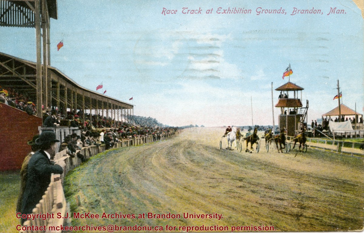
Postcard shows the grandstand and race track located at the Exhibition Grounds (now the site of the Keystone Centre/Westman Communications Place) in the south end of Brandon, Manitoba. The bleachers are filled with people and spectators also line the fence alongside the track. Five harness racers are making their way along the track. An observation tower and possible gazebo for dignitaries is located inside the track.
Notes
The back of the postcard is address to Mrs. Sharpe of Banff, Alberta. A green King George One Cent stamp has been postmarked Sault Ste. Maire, Ont., July 6, 1910. The message reads: Lake Superior, My dear. How are you? Glad you are charmed with B. don't get too fat. Tell Mrs. Coates my state room companion is Miss Rutherford of B. Coll: she got on at Port Arthur. Having a lovely trip. It was hard parting at B. .......Address 14 Deer Park, Toronto. Postcard manufactured by Stedman Bros. Ltd., Brantford, Canada. S.B. 2376. Made in Germany.
Name Access
Brandon Fairgrounds
Subject Access
fairs
exhibitions
Brandon Exhibitions & Facilities
race tracks
horse racing
Storage Location
RG 5 photograph storage drawer 2 (hanging photos)
Images
Show Less

Early scene of Rosser Avenue facing west

http://archives.brandonu.ca/en/permalink/descriptions13782
Part Of
Fred McGuinness collection
Description Level
Item
GMD
graphic
Date Range
c.1882
Accession Number
20-2009
Part Of
Fred McGuinness collection
Creator
Photographer: I. Bennetto & Co. (Winnipeg)
Description Level
Item
Series Number
McG 9
Item Number
20-2009.93
Accession Number
20-2009
GMD
graphic
Date Range
c.1882
Physical Description
9.25" x 6.26" (b/w)
Material Details
on matting
Physical Condition
Photograph mat is bent. Emulsion problems with image.
Scope and Content
Photograph shows Rosser Avenue in its incipient stages. Canvas tents are mixed amongst wooden structures. The James Smart Hardware store, Winter & O'Neail Groceries & Provisions, and the law office of F.G.A. Henderson in the Molesworth Block can be seen on the north side of Rosser Avenue. A street sign designating 6th Street can be seen below the Winter & O'Neail sign. A horse and buggie is traveling down the dirt track that is Rosser Avenue. Groups of men can be seen congregating outside some of the local businesses.
Notes
Front of photograph reads: Rosser Avenue, Brandon 1882-1883, from east of Six Street. Back of photograph is stamped: I. Bennetto & Co., Photographers, Opposite Post-Office, Winnipeg, Man.
Name Access
James Smart Hardware store
Winter & O'Neail Groceries and Provisions
F.G.A. Henderson Law Office
Molesworth Block
Rosser Avenue
Subject Access
downtown
hardware stores
Pioneers
dry goods
street scenes
Brandon Street Scenes Before 1940
grocery stores
lawyers
Storage Location
RG 5 photograph storage drawer 2 (hanging photos)
Images
Show Less

Stores near the corner of Rosser Avenue and 6th Street

http://archives.brandonu.ca/en/permalink/descriptions13783
Part Of
Fred McGuinness collection
Description Level
Item
GMD
graphic
Date Range
1881-1882
Accession Number
20-2009
Part Of
Fred McGuinness collection
Description Level
Item
Series Number
McG 9
Item Number
20-2009.94
Accession Number
20-2009
GMD
graphic
Date Range
1881-1882
Physical Description
9.25" x 6.25" (b/w)
Material Details
on matting
Physical Condition
Corners of photograph mat are bent. Picture is cracked.
Scope and Content
Photograph shows an early view of Brandon's 6th Street in the 1880s. The Winter & O'Neail Groceries & Provisions and James Smart Hardware storefronts have been photographed. A street sign designating 6th Street can be seen below the Winter & O'Neail sign. A horse and cart is parked in front of the grocery store. A number of men wearing hats and jackets are standing along the boardwalk while posing for the picture. Lumber/timber saws are displayed in teh windows of the hardware store.
Notes
Front of photograph reads: 6th Street, Brandon, Manitoba, 1881-1882, Entrance [to Winter & O'Neail] corner of Rosser Ave & 6th Street.
Name Access
James Smart Hardware store
Winter & O'Neail Groceries and Provisions
6th Street
Subject Access
downtown
hardware stores
Pioneers
dry goods
street scenes
Brandon Street Scenes Before 1940
grocery stores
Storage Location
RG 5 photograph storage drawer 2 (hanging photos)
Images
Show Less

Intersection of Rosser Avenue and 8th Street facing west

http://archives.brandonu.ca/en/permalink/descriptions13786
Part Of
Fred McGuinness collection
Description Level
Item
GMD
graphic
Date Range
[19--]
Accession Number
20-2009
Part Of
Fred McGuinness collection
Creator
Photographer: Brandon Sun
Description Level
Item
Series Number
McG 9
Item Number
20-2009.97
Accession Number
20-2009
GMD
graphic
Date Range
[19--]
Physical Description
8.5" x 5.25" (b/w)
Material Details
reproduction
Scope and Content
Photograph shows the 800 block of Rosser Avenue facing west. On the south side of Rosser Avenue the Nation Block, Christie's Bookstore, and Reesor's Clock can be seen. A number of horse and buggies/carriages are travelling along Rosser Avenue.
Name Access
Rosser Avenue
Reesor’s Jewellery
Reesor's clock
Subject Access
downtown
street scenes
Brandon Street Scenes Before 1940
Transportation
horses
buggies
Storage Location
RG 5 photograph storage drawer 2 (hanging photos)
Images
Show Less

20 records – page 1 of 1.