Donkersloot began working at Brandon University in 1970/1971 as the Clerk of Works. From 1973 until his retirement, he was the Director of Physical Plant.
The Site Services building was built in 1971.
Custodial History
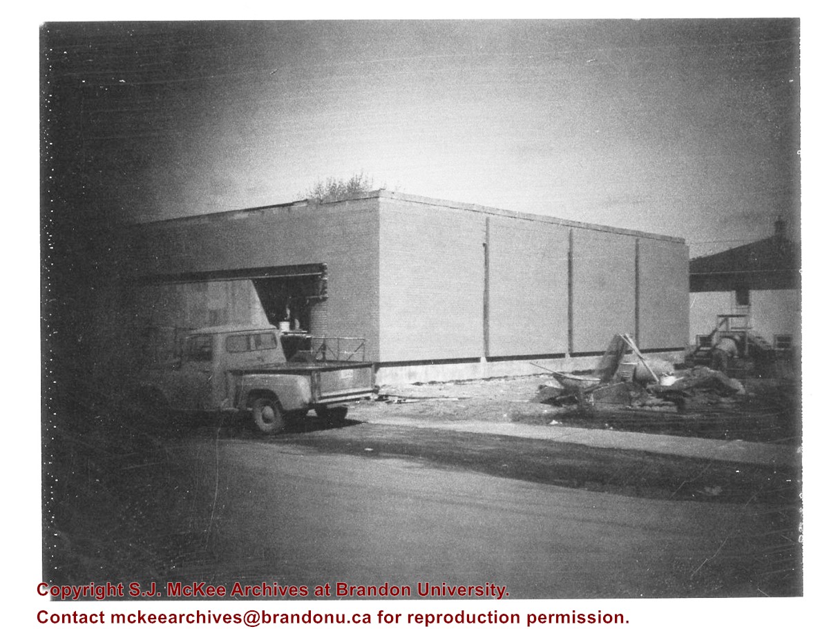
Photograph was taken by Tom Donkersloot during construction and stored in albums in the Physical Plant H-Hut until they were transfered to the McKee Archives by Doug Duncalf in May 2008.
Scope and Content
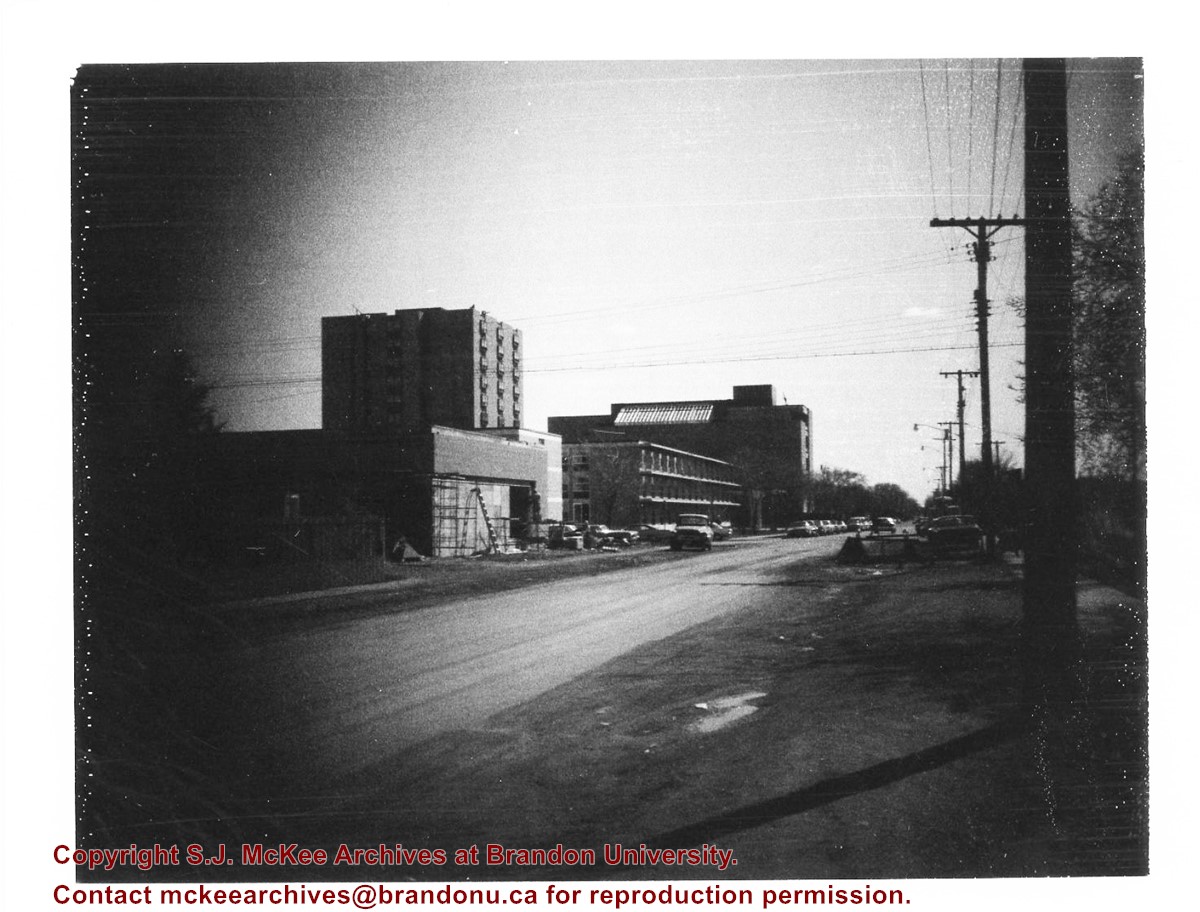
Photograph shows construction of Brandon University's Site Services Building located on Louise Avenue at the corner of 20th Street. Also visible are McMaster Hall, Flora Cowan Women's Residence and the John R. Brodie Science Centre. Photograph is looking east/northeast from approximately 21st Street.
Notes
Donkersloot recorded the date and time each photograph was taken on the back of the photos.
Donkersloot began working at Brandon University in 1970/1971 as the Clerk of Works. From 1973 until his retirement, he was the Director of Physical Plant.
The Site Services Building was built in 1971.
Custodial History
Photograph was taken by Tom Donkersloot during construction and stored in albums in the Physical Plant H-Hut until they were transfered to the McKee Archives by Doug Duncalf in May 2008.
Scope and Content
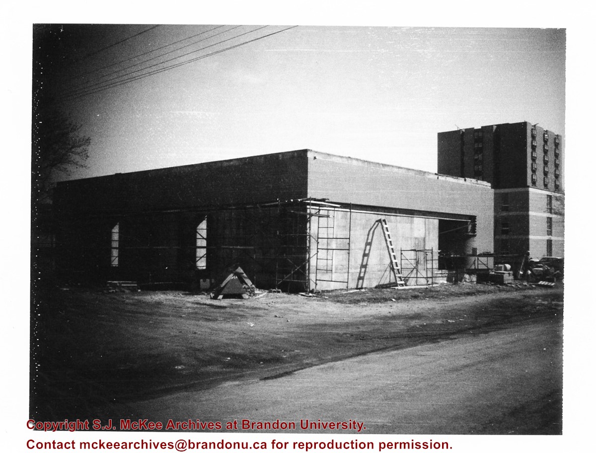
Photograph shows construction of Brandon University's Site Services Building located on Louise Avenue at the corner of 20th Street. Also visible are McMaster Hall and part of Darrach Hall. Photograph is looking northeast.
Notes
Donkersloot recorded the date and time each photograph was taken on the back of the photos.
Donkersloot began working at Brandon University in 1970/1971 as the Clerk of Works. From 1973 until his retirement, he was the Director of Physical Plant.
The Site Services Building was built in 1971.
Custodial History
Photograph was taken by Tom Donkersloot during construction and stored in albums in the Physical Plant H-Hut until they were transfered to the McKee Archives by Doug Duncalf in May 2008.
Scope and Content
Photograph shows construction of Brandon University's Site Services Building located on Louise Avenue at the corner of 20th Street. Photograph is looking northwest.
Notes
Donkersloot recorded the date and time each photograph was taken on the back of the photos.
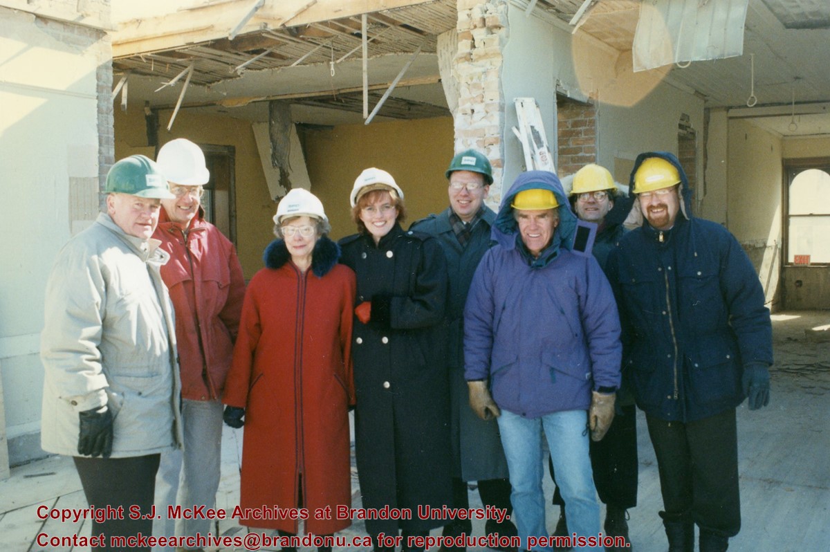
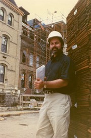
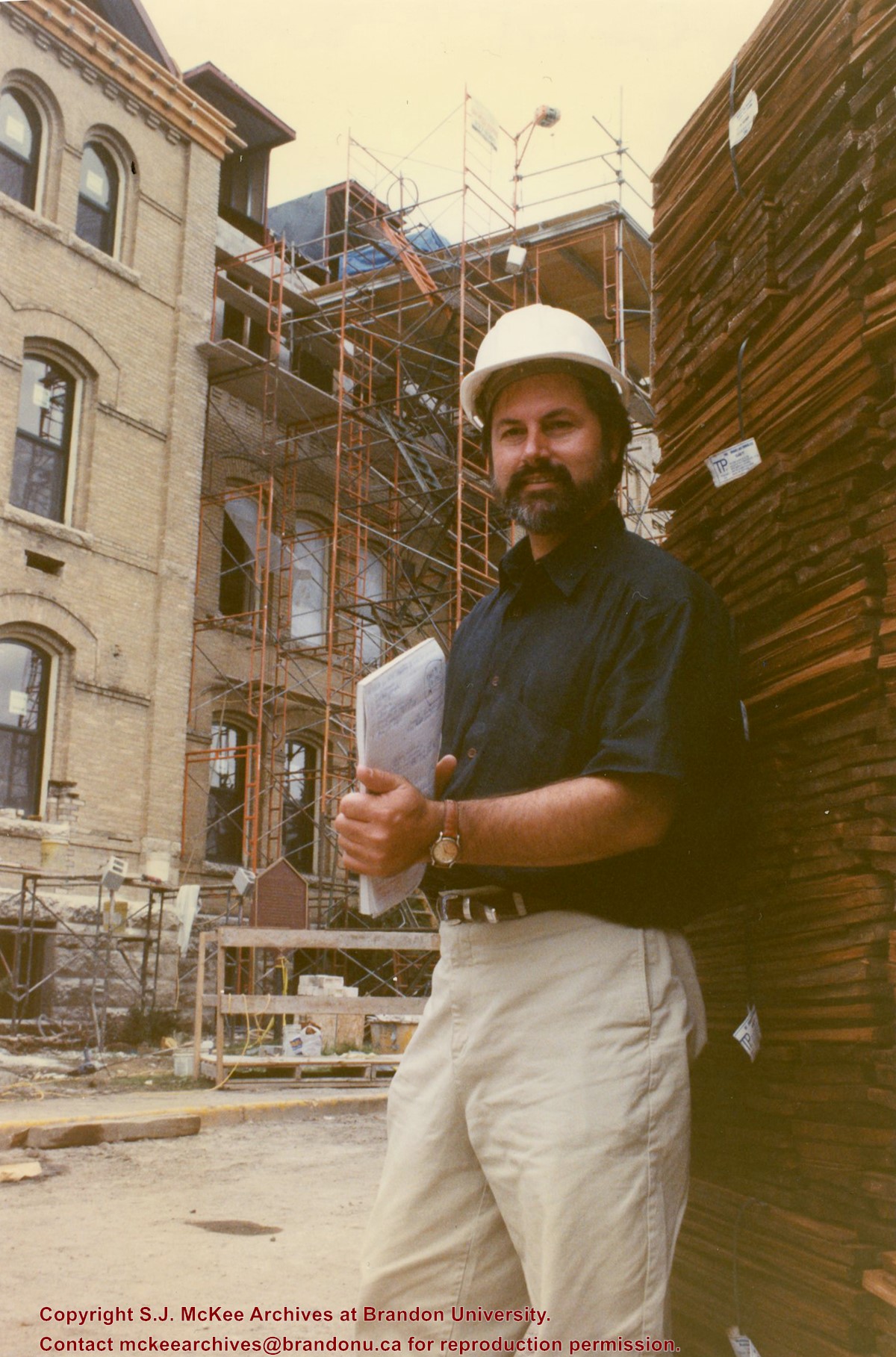
Photograph shows members of the Brandon University Foundation during a tour of the construction site. Members include: Scott Stewart, Doug Adams, Sheri Decter-Hirst.
Accession 3-1997 (84 photographs, various diplomas; 1886-1960) contains a variety of photographs of buildings and streetscapes of the 100 block of Tenth Street and various Hughes properties in the city. In addition, there are photographs of the "Founders of Hughes and Co," a parade on Tenth Street in 1924, the Wheat City Business College Hockey Team 1912, three photographs of the Port of Churchill in 1931, three photographs of threshing crews on Hughes and Company property, a Great War military contingent from Brandon including JRC Evans, and four family photographs.
Stuckey left a variety of materials in his collection in an unsorted state. Rather than allocate those materials to one of the existing sub-series, the McKee Archives chose to artificially create this sub-series, which has been designated "unsorted materials."
For history/bio information for Lawrence Stuckey see the collection level description of the Lawrence Stuckey collection.
Custodial History
For custodial history see the collection level description of the Lawrence Stuckey collection.
Scope and Content
Sub-series consists of photographic prints, photograph albums, postcards and negatives covering a variety of subjects including Brandon, ships, boats, threshermens' reunions, and rural Manitoba. Some of the prints correspond with negatives held in other sub-series in the Stuckey collection. If possible, the connection between the print and negative has been made at the item level. Some of the items are original and quite rare.
The dates given for many of the prints in this sub-series refer to the date the photograph was taken and not the date the print was made from the original negative.
Notes
Unidentifiable photographs not taken by Lawrence Stuckey and redundant prints were culled.
Repro Restriction
The McKee Archives is the copyright holder for the Stuckey materials.
See sub sub series level (RG 6, 8.4.1) for history/bio information.
Custodial History
See sub sub series level (RG 6, 8.4.1) for custodial history.
Scope and Content
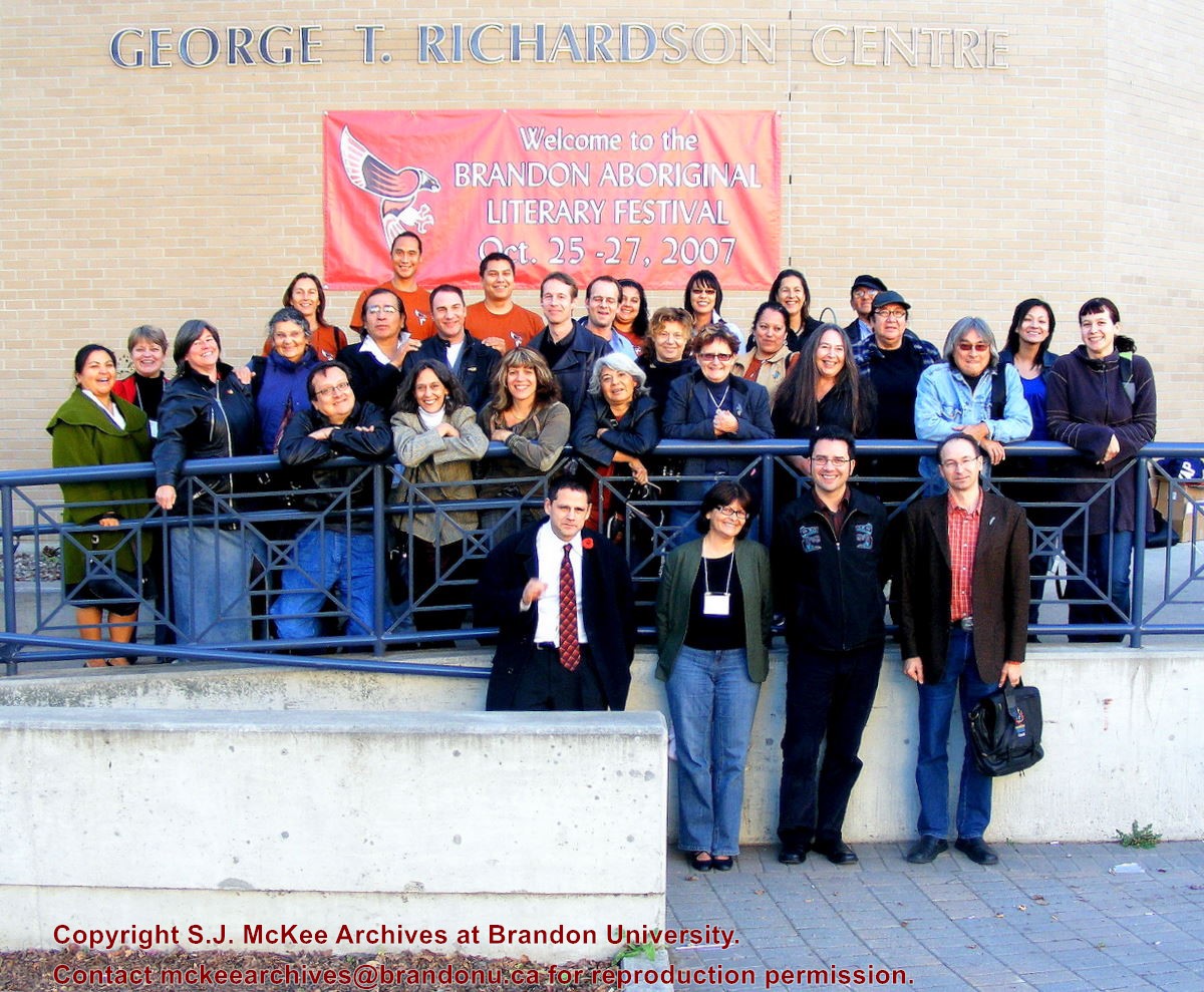
Group photograph of participants, volunteers and organization committee members taken in front of the George T. Richardson Centre.
Back Row (L-R): Dot Sinclair; John Steppler; ?; Paul DePasquale; Cheyenne Spence; Jill Oman; Marine Debryne; Errol Kinistino
Second Row (L-R): Di Brandt; Maria Campbell; Tomson Highway; Greg Scofield; Warren Cariou; ?; Lisa Whitecloud; Marie Baker (Annharte); Rosanna Deerchild
Third Row (L-R): Eden Robinson, Yvette Nolan; Daniel David Moses; Joanne Arnott, Kateri Akiwenzie-Damm; Louise Halfe; Linda Burridge; Colleen Cutschall; Duncan Mercredi; Katherena Vermette
Front Row (L-R): Neal McLeod; Lorraine Meyer; Richard Van Camp; Armand Garnet Ruffo
Storage Location
RG 6 Brandon University fonds
Series 8: Library Services
8.4 Library special events
8.4.1 Brandon Aboriginal Literary Festival
For history/bio information see the collection level description of the Lawrence Stuckey collection.
Custodial History
For custodial history see the collection level description of the Lawrence Stuckey collection.
Scope and Content
This sub-series consists of photographic negatives related to the history of Brandon, Manitoba.
All of the images contained within this sub-series were part of Mr. Stuckey’s lifelong personal collection of photographic negatives and prints. Images include those related to people, street scapes, buildings, various city departments and so forth.
Notes
All of the images from Mr. Stuckey’s collection of negatives and prints were reproduced and digitized using an Epson scanner and software suite. All attempts have been made to reproduce the images in such a manner that balances our desire to portray the negatives and photographs as they originally appear, with the need to create an optimal digital image for viewing. Therefore it is noted that minor alterations to image size and contrast have occurred.
With few exceptions, all digitizing and database entry of images and descriptions was conducted during the summer of 2009 at Brandon University by Patrick Elves.
Repro Restriction
The McKee Archives is the copyright holder for the Stuckey materials.
Storage Location
Lawrence Stuckey collection
Arrangement
Unless otherwise noted, the arrangement of these images was drawn from the original classification scheme used by Mr. Stuckey.
The information specific to each image, for the most part, was gained from Mr. Stuckey’s personal notes regarding that particular photograph or similar photograph. Observations or notes contained within square brackets are explanatory or missing materials that have been added by someone other than Mr. Stuckey.
We have attempted to present the information that accompanies each image in the same format as was used by Mr. Stuckey himself.
Subseries 1 - Brandon History
A. People
B. Bridges
C. Streets
D. Buildings
E. Business
F. Fire Dept.
G. Hospitals
H. Industries
I. Streetcars
J. Utilities
K. Construction
L. Transportation (other than rail)
M. Exhibition
N. Misc. History
O. Environs
P. Railroads
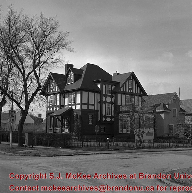
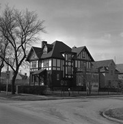
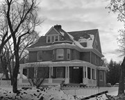
"Maley House was constructed in 1912 by Henry F. Maley, founder and owner of the Brandon Brewery Company. The house was purchased by Dr. McDiarmid, whose family occupied the home for the next sixty years. It is currently used as a bed and breakfast establishment" (Manitoba Culture, Heritage, Tourism and Sport). Maley House is listed as Manitoba Municipal Heritage Site No. 80.
Custodial History
For custodial history see the collection level description of the Lawrence Stuckey collection.
Scope and Content
[Maley House]; Elizabethan style
Notes
Located at 16th St. & Victoria Ave.
[Mr. Stuckey put two negatives in the same envelop, numbering them DE4a and DE4b. We have separated them.]
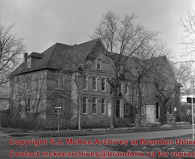
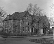
"Built in 1892 by Bell Brothers Construction, Lorne Terrace is a typical terrace house - a facility that combined several addresses in what would appear to be a very large house" (Manitoba Culture, Heritage, Tourism and Sport). It is currently listed as Manitoba Municipal Heritage Site No. 197.
Custodial History
For custodial history see the collection level description of the Lawrence Stuckey collection.
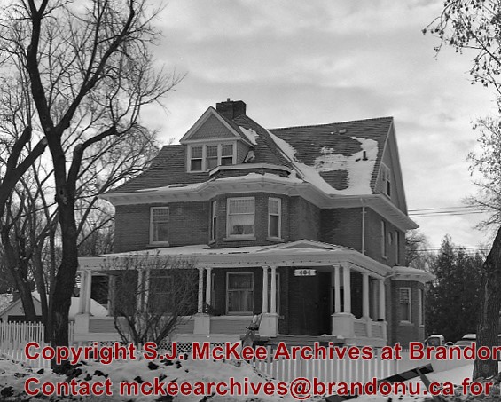
"Christie House was built in 1905 for Ernest Lisle Christie, founder of the huge stationary and school supply business that still bears his name. Christie and his family lived here until 1934, and the house was occupied by other family members until 1966. The house was designed by Brandon architect W.A. Elliott and was constructed by the local firm of G.C. Taylor" (Manitoba Culture, Heritage, Tourism and Sport). Christie House is listed as Manitoba Municipal Heritage Site No. 20.
Custodial History
For custodial history see the collection level description of the Lawrence Stuckey collection.
Introduction
Information on archaeological materials in this locale first came to the attention of Dr. Nicholson through Doug Jackson, a local artifact collector from Souris. Doug had observed archaeological materials that included bone, ceramics and lithic material that had been exposed by municipal road building activity, northwest of Lauder Manitoba
Environment
The Makotchi-Ded Dontipi locale is located among stabilized sand dunes in the Lauder Sandhills in Southwestern Manitoba, northwest of the village of Lauder. The area is a mosaic of medium grass prairie and copses of aspen poplar and aspen-oak, together with intermittent sedge grass marshes and small ponds. These wetlands are bordered with balsam poplar, water birch, willows and red osier dogwood.
The well-drained upland forest also contains saskatoon, chokecherry, wild current, hazelnut bushes and occasional wild plums. Lowland areas have nannyberries and high-bush cranberry. Wild strawberries grow in lightly shaded areas along trail margins and in open patches in aspen forest.
History of Excavations
The Makotchi-Ded Dontipi locale is a virtual "island" of forest and marshlands in a vast expanse of mixed grass prairie. This archaeologically and environmentally rich area was given the Dakota name Makotchi-Ded Dontipi, meaning "the place where we live".
Summation
Prior to European settlement, the area was a rich environment for hunter-gatherer people. Archaeological investigations from 1992 to 2002 have revealed numerous sites within the locale. Some of these sites have been extensively excavated while others have been identified or tested.
Seven sites that have been identified in this locale range in age from the historic through protohistoric periods and extend into the middle precontact period. The major sites are the initial Middle Missouri Duthie site, the late precontact Jackson, Bradshaw sites and the protohistoric Twin Fawns, Schuddemat and Hollow B sites. The multi-component Vera site includes historic Métis, late precontact Vickers Focus, and middle precontact Besant, Pelican Lake, McKean Complex and Oxbow occupations. Over 230 units were excavated as well as numerous test pits and several extensive surveys.
Scope and Content
Scope and Content
The Series has been divided into seven sub-series, including (1) Duthie site (2) Jackson site (3) Twin Fawns site (4) Vera site (5) Schuddemat site (6) Bradshaw site (7) Hollow B site.
The Duthie site is the first site identified in the Makotchi-Ded Dontipi locale. It was reported to Dr. Bev Nicholson by Doug Jackson, a local collector who had observed archaeological materials that had been exposed during the construction of Maple Hill Road northwest of Lauder. The site is named after the landowner, Randy Duthie.
The initial inspection of the exposed materials indicated that the eastern half of the site had been severely impacted by raising a road grade using an elevating grader. However, an undetermined amount of the site remained to the west, flanked by a low sand dune. Testing and preliminary excavations were conducted in 1992-93. In 1994 a field school added to the excavated sample. The undisturbed portion of the site, west of Maple Hill Road was situated at the base of a low sand dune and had an aspen and willow forest cover. The water table was approximately one meter below surface at the time of excavation. A rising water table has since prevented further excavations.
Two dates on bone collagen were obtained during excavations. These were 880+/-80 B.P. (Beta 62705) and 970+/-40 B.P. cal. 1030 A.D. (TO 13366). These dates are consistent with an Initial Middle Missouri cultural assignment. The site occupation is identified by the distinctive ceramics found there. Ceramics at the Duthie Site are tool impressed with incising and lip modeling with fabric impressions on most vessels. Jill Taylor analysed the ceramics from the site for a Specialist thesis, Brandon University (1994) and a Masters of Arts degree from the University of Saskatchewan. (Taylor 1995).
Analysis of residue from Duthie site pottery by Matthew Boyd recovered corn (Zea mays) phytoliths and bean (Phaseolus sp.) starch grains indicating consumption of these domesticates at the Duthie site. (Boyd 2006)
The occupation of this site indicates a migration of people from the south who were well acquainted with horticultural farming. These people had previously migrated to South Dakota following river valleys into the central plains from the eastern woodlands during late Hopewell times. It appears that they later migrated well to the north into southern Manitoba but there is no evidence that they remained there for more than a single year.
Boyd, M., C. Surette and B.A. Nicholson. 2006 Archaeobotanical Evidence of Prehistoric Maize (Zea mays) Consumption at the Northern Edge of the Great Plains. Journal of Archaeological Science 33: 1129-1140.
Taylor, J. 1994 An analysis of the ceramics recovered during 1992 and 1993 at the Precontact Duthie Site (DiMe-16). Specialist thesis, Brandon University.
Scope and Content
The Series has been divided into seven sub-series, including (1) Duthie site (2) Jackson site (3) Twin Fawns site (4) Vera site (5) Schuddemat site (6) Bradshaw site (7) Hollow B site.
Field journals have been scanned in multi-page PDF files.
History / Biographical
The Crepeele site was excavated in 2003 as Crepeele 3. Standard archaeological methods were used to excavate the units. Excavation units were initially numbered as units 10, 11, 12 & 13. These numbers have been changed on the catalogue to XU 110 – 113, due to duplication in 2005. Corresponding documents have been changed to reflect the amended excavation unit numbers, however the field journals may contain the initial numbers.
Scope and Content
Record of daily observations at the site including: excavation methods, items recovered, features, local environment and weather.
An oversized photograph is any photograph that exceeds 8" x 11". In some cases the photograph itself is of regular size but the matting makes it oversize.
Scope and Content
Series consists of the oversize photographs in the Brandon University photograph collection. Many of the oversize pictures are class photos from the early years of Brandon College (1900-1930). The series also includes oversize portraits of important figures in the history of Brandon College and University, such as John R. Brodie, A.E. McKenzie, and J.R.C. Evans.
Bertha Miriam Clark was born on Prince Edward Island but attended public and high school in Brandon, MB. She was a member of the Class of 1929 and served as Lady Stick in her final year at Brandon College.
Clark married J. Scott Leith, Brandon College Class of 1928. Scott and Bertha Leith's son James Clark Leith is in the Canadian Who's Who.
Custodial History
Album was sent to Pat Britton, Brandon University Director of Alumni Relations, by Bertha Leith in April 1991. Britton then transferred it to the McKee Archives.
Scope and Content
Fonds consists of a small accordian style photograph album (7 x 10.5 x 3.5 cm) created by Bertha Clark during her years at Brandon College. The photographs, which measure 4" x 2.75", depict numerous people and events.
Notes
History/Bio information taken from the 1928-1929 Sickle.