Skip header and navigation

Revise Search

20 records – page 1 of 1.

S-16 Senator Haidasz's Motion/Abortion/

http://archives.brandonu.ca/en/permalink/descriptions6399
Part Of
RG 6 Brandon University fonds
Description Level
File
GMD
textual records
Date Range
1988
Part Of
RG 6 Brandon University fonds
Description Level
File
Series Number
MG 3 1.14.1
File Number
1452
GMD
textual records
Date Range
1988
Physical Description
1 file
Scope and Content
File consists of correspondence
Storage Location
RG 6 Brandon University fonds MG 3 Brandon University Teaching and Administration 1.14.1 W. Leland Clark - political career Box 60
Show Less

Aerial view - Brandon University campus

http://archives.brandonu.ca/en/permalink/descriptions7989
Part Of
Brandon University Photograph collection
Description Level
Item
GMD
graphic
Date Range
c. 2000
Part Of
Brandon University Photograph collection
Creator
Photograph commissioned by Brandon University and taken by Yourview Aerial Scenics Ltd.
Description Level
Item
Series Number
2.1
Item Number
BUPC 2.1.55
GMD
graphic
Date Range
c. 2000
Physical Description
6" x 4" (colour)
Scope and Content
View is southwest from approximatley 16th Street between Princess and Rosser Avenues. Photograph shows the Brandon University campus, as well as surrounding residential blocks, including Flemming, J.R. Reid and Vincent Massey schools.
Subject Access
aerial photographs
campus photographs
campus buildings
Brandon streets
Images
Show Less

Aerial view - Brandon University campus

http://archives.brandonu.ca/en/permalink/descriptions7990
Part Of
Brandon University Photograph collection
Description Level
Item
GMD
graphic
Date Range
c. 2000
Part Of
Brandon University Photograph collection
Creator
Photograph commissioned by Brandon University and taken by Yourview Aerial Scenics Ltd.
Description Level
Item
Series Number
2.1
Item Number
BUPC 2.1.56
GMD
graphic
Date Range
c. 2000
Physical Description
6" x 4" (colour)
Scope and Content
View is west southwest from approximatley 16th Street between Princess and Lorne Avenues. Photograph shows the Brandon University campus, as well as surrounding residential blocks between 16th and 23rd Streets, Princess and Louise Avenues..
Subject Access
aerial photographs
campus photographs
campus buildings
Brandon streets
Images
Show Less

Aerial view - Brandon University campus

http://archives.brandonu.ca/en/permalink/descriptions7991
Part Of
Brandon University Photograph collection
Description Level
Item
GMD
graphic
Date Range
c. 2000
Part Of
Brandon University Photograph collection
Creator
Photograph commissioned by Brandon University and taken by Yourview Aerial Scenics Ltd.
Description Level
Item
Series Number
2.1
Item Number
BUPC 2.1.57
GMD
graphic
Date Range
c. 2000
Physical Description
6" x 4" (colour)
Scope and Content
View is west from approximatley 17th Street between Lorne and Louise Avenues. Photograph shows a portion of the Brandon University campus (excluding the Education Building and anything north of it), as well as surrounding residential blocks from approximatley 17th Street to 22nd Street.
Subject Access
aerial photographs
campus photographs
campus buildings
Brandon streets
Images
Show Less

Aerial view - Brandon University campus

http://archives.brandonu.ca/en/permalink/descriptions7992
Part Of
Brandon University Photograph collection
Description Level
Item
GMD
graphic
Date Range
c. 1990
Part Of
Brandon University Photograph collection
Description Level
Item
Series Number
2.1
Item Number
BUPC 2.1.58
GMD
graphic
Date Range
c. 1990
Physical Description
5" x 3.5" (colour)
Scope and Content
View is west northwest from approximatley 16th Street and Louise Avenue. Photograph shows the Brandon University campus, prior to the Library Extension, and a large portion of the city to the west of the campus.
Subject Access
aerial photographs
campus photographs
campus buildings
Brandon streets
Images
Show Less

Aerial view - Brandon University campus

http://archives.brandonu.ca/en/permalink/descriptions7993
Part Of
Brandon University Photograph collection
Description Level
Item
GMD
graphic
Date Range
c. 1990
Part Of
Brandon University Photograph collection
Description Level
Item
Series Number
2.1
Item Number
BUPC 2.1.59
GMD
graphic
Date Range
c. 1990
Physical Description
5" x 3.5" (colour)
Scope and Content
View is northwest from approximatley 16th Street and Louise Avenue. Photograph shows the Brandon University campus, prior to the Library Extension, and a large portion of the city to the west of the campus.
Subject Access
aerial photographs
campus photographs
campus buildings
Brandon streets
Show Less
Part Of
Brandon University Photograph collection
Description Level
Item
GMD
graphic
Date Range
c. 1985
Part Of
Brandon University Photograph collection
Description Level
Item
Series Number
2.1
Item Number
BUPC 2.1.60
GMD
graphic
Date Range
c. 1985
Physical Description
5" x 3.5" (colour)
Scope and Content
Photograph shows the removal of one of the houses formerly located on 20th Street between Louise and Princess Avenues. The houses on those blocks were removed to create parking lots for the University. A Fed Zavislak Ltd. Well Drilling & Trucking pickup truck is visible at the curb.
Subject Access
campus photographs
Brandon streets
Images
Show Less
Part Of
Brandon University Photograph collection
Description Level
Item
GMD
graphic
Date Range
c. 1985
Part Of
Brandon University Photograph collection
Description Level
Item
Series Number
2.1
Item Number
BUPC 2.1.61
GMD
graphic
Date Range
c. 1985
Physical Description
5" x 3.5" (colour)
Scope and Content
Photograph shows the removal of one of the houses formerly located on 20th Street between Louise and Princess Avenues. The houses on those blocks were removed to create parking lots for the University.
Subject Access
campus photographs
Brandon streets
Images
Show Less

Brandon University campus construction

http://archives.brandonu.ca/en/permalink/descriptions8005
Part Of
Brandon University Photograph collection
Description Level
Item
GMD
graphic
Date Range
c. 1996
Part Of
Brandon University Photograph collection
Creator
Photographer: Sandy Black
Description Level
Item
Series Number
2.1
Item Number
BUPC 2.1.71
GMD
graphic
Date Range
c. 1996
Physical Description
4" x 6" (colour)
Scope and Content
View is northeast probably from the roof of McMaster Hall. Photograph shows the construction of the new roof on Clark Hall and the Brandon College Building. A portion of the east side of the 000 and 100 blocks of 18th Street, as well as the corner of 18th Street and Rosser Avenue are visible in the upper left hand corner. This includes the "Downtown Brandon" sign.
Subject Access
campus photographs
campus buildings
campus construction
Brandon streets
Images
Show Less

Brandon University campus construction

http://archives.brandonu.ca/en/permalink/descriptions8006
Part Of
Brandon University Photograph collection
Description Level
Item
GMD
graphic
Date Range
c. 1996
Part Of
Brandon University Photograph collection
Creator
Photographer: Sandy Black
Description Level
Item
Series Number
2.1
Item Number
BUPC 2.1.72
GMD
graphic
Date Range
c. 1996
Physical Description
6" x 4" (colour)
Scope and Content
View is north northeast probably from the roof of McMaster Hall. Photograph shows the construction of the new roof on Clark Hall and the Brandon College Building, as well as the construction of the extension to Clark Hall and the skywalk. Portions of the city as far north as the Assiniboine River are also visible.
Subject Access
campus photographs
campus buildings
campus construction
Brandon streets
Images
Show Less

Brandon University campus construction

http://archives.brandonu.ca/en/permalink/descriptions8016
Part Of
Brandon University Photograph collection
Description Level
Item
GMD
graphic
Date Range
c. 1996
Part Of
Brandon University Photograph collection
Creator
Photographer: Sandy Black
Description Level
Item
Series Number
2.1
Item Number
BUPC 2.1.82
GMD
graphic
Date Range
c. 1996
Physical Description
4" x 6" (colour)
Scope and Content
View is northeast from the Brandon College Building. Photograph shows the inside of the Brandon College Building after it had been gutted and then partially rebuilt. The exterior fascade of the west side of the building can be clearly seen in this photograph. A number of houses on the east side of 200 block of 18th Street are also visible, as is the stone fence on Princess Avenue and the flag pole on the front lawn.
Subject Access
campus photographs
campus construction
Brandon streets
Images
Show Less

Brandon University campus construction

http://archives.brandonu.ca/en/permalink/descriptions8018
Part Of
Brandon University Photograph collection
Description Level
Item
GMD
graphic
Date Range
c. 1996
Part Of
Brandon University Photograph collection
Description Level
Item
Series Number
2.1
Item Number
BUPC 2.1.84
GMD
graphic
Date Range
c. 1996
Physical Description
6" x 4" (colour)
Scope and Content
View is north northeast from the roof of McMaster Hall. Photograph shows the campus under construction during the renovation of the Brandon College Building and Clark Hall. The photograph was taken in late fall after the roof had been removed from the buildings but before the construction of the extension of Clark Hall. Construction materials litter the courtyard and driveway. The view looking north extends to The North Hill - a number of residential blocks, particularly to the northeast of 18th Street are visible. Buildings include the International Harvester Building and Kin Village.
Subject Access
campus photographs
campus buildings
campus construction
Brandon streets
Images
Show Less

Brandon University campus construction

http://archives.brandonu.ca/en/permalink/descriptions8020
Part Of
Brandon University Photograph collection
Description Level
Item
GMD
graphic
Date Range
c. 1996
Part Of
Brandon University Photograph collection
Creator
Photographer: Sandy Black
Description Level
Item
Series Number
2.1
Item Number
BUPC 2.1.86
GMD
graphic
Date Range
c. 1996
Physical Description
6" x 4" (colour)
Scope and Content
View is north northeast probably from the roof of McMaster Hall. Photograph shows the construction of the new roof on Clark Hall and the Brandon College Building, as well as the construction of the extension to Clark Hall and the skywalk. The view looking north extends to The North Hill - a number of residential blocks, particularly to the northeast of 18th Street are visible. Buildings include the International Harvester Building and Kin Village.
Subject Access
campus photographs
campus buildings
campus construction
Brandon streets
Images
Show Less

Dennis Anderson and John Jardine

http://archives.brandonu.ca/en/permalink/descriptions8117
Part Of
Brandon University Photograph Collection
Description Level
Item
GMD
graphic
Date Range
c. 1996
Part Of
Brandon University Photograph Collection
Description Level
Item
Series Number
2.2
Item Number
2.2.45
GMD
graphic
Date Range
c. 1996
Physical Description
6"x 4" (colour)
Scope and Content
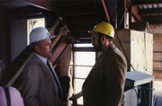
Photograph shows President Dennis Anderson and John Jardine, Head of Physical Plant, in either Clark Hall or the Brandon College Building during renovations.
Images
Show Less

John Weldon Grant collection

http://archives.brandonu.ca/en/permalink/descriptions8219
Part Of
RG 6 Brandon University fonds
Description Level
Sub-series
GMD
multiple media
Date Range
1910; predominant 1961-1977.
Accession Number
3-2008
Part Of
RG 6 Brandon University fonds
Description Level
Sub-series
Series Number
MG 3 1.21
Accession Number
3-2008
GMD
multiple media
Date Range
1910; predominant 1961-1977.
Physical Description
40 cm text; prints and art work.
History / Biographical
Professor John Weldon Grant was born 12 March 1919 in Sunnybrae, Nova Scotia, son of Alec and Linda Grant. He was raised in Sunnybrae and graduated from Pictou Academy in 1937. Prof. Grant entered Pine Hill Divinity School to study Theology. During his ministerial internship, he taught and preached in Rabbit Lake and Biggar, Saskatchewan. He graduated from Pine Hill in 1943 and entered the mission field with the United Church. Professor Grant moved to Trinidad & Tobago in the 1940s. There he taught in both San Fernando and Siparia, towns located in the southwest tip of the island. Weldon Grant was the first head master off the Iere High School School in Siparia when it opened in 1955. Professor Grant is recalled by Kenneth Ramchand in his _The West Indian Novel And Its Background_ as “his beloved English teacher” reading from an early Sam Selvon novel in a “Saskatchewan version of Trinidad dialect.” That he was teaching Selvon – a West Indian writer - testifies to Grant’s cultural pluralism. See Kenneth Ramchaud, _The West Indian Novel and its bachground_ (London: Faber and Faber, 2001 edition). Professor Grant and Bernice Emma Moats were married in Gray, Saskatchewan 30 June 1954. They adopted three children in Nova Scotia and returned to Trinidad. In 1961, the Grants returned to Canada. Weldon taught for one year at Vincent Massey High School and then joined the English Department at Brandon University where he taught in the English department until his retirement on August 31, 1984. During a sabbatical he spent six months exploring Ireland and the poets that had been inspired by its countryside. He also loved stories of the sea and read many varied authors, both factual and fiction.
Custodial History
Records were collected by Weldon Grant during his teaching career in Trinidad and Canada.
Scope and Content
In the course of his teaching career in Trinidad & Tobego and at Brandon University Professor Grant acquired and retained a number of items with cultural, scholarly and sentimental value. These incude The First Folio of Shakespeare, prepared by Charlton Himan, [Academic ed.]. Imprint New York : W.W. Norton, 1968. xxvii, 928 p. : port. ; 37 cm. Mr. William Shakespeares comedies, histories, & tragedies. Published according to the true original copies. London, Printed by Isaac Iaggard, and Ed. Blount, 1623. The facsimile is described as "an ideal copy in which each page represents the best page selected from one of the 29 most satisfactory copies of the 80 copies in the Folger Shakespeare Library." 1 Self prononcing Holy Bible, Oxford 1910. 1 print 22.4" x 17," "Baking in a Clay Oven," by Trinidad artist David Moore, June 1977 printed in Trinidad by the College Press. 2 water colour paintings 17.5" x 12" by artist "AM." One titled San Fernando (1961) one titled Royal Palm, Trinidad (1960). 1 black and white portrait 10" x 13" of Governor general Roland Michener and his wife (No: A-2) copyright Karsh dated 1970. 1 Asian art work, 12.5" x 18" embroidery on silk.
Notes
Weldon Grant history/bio from Weldon Grant obituary Brandon Daily Sun c. April 14, 1999.
Name Access
Weldon Grant
Subject Access
English Department
Storage Location
MG 3 Brandon University Teaching and Administration MG 3 1.21 John Weldon Grant
Show Less

Aerial view: Brandon College campus

http://archives.brandonu.ca/en/permalink/descriptions8272
Part Of
Aerial views and campus photographs
Description Level
Item
GMD
graphic
Date Range
c. 1964
Part Of
Aerial views and campus photographs
Description Level
Item
Series Number
2.1
Item Number
2.1.1
GMD
graphic
Date Range
c. 1964
Physical Description
4" x 5" (b/w)
Scope and Content
Photograph is looking northwest from approximately the southeast corner of 18th Street and Louise Avenue.
Name Access
Flora Cowan Residence
Subject Access
Aerial views Brandon College
Images
Show Less

John R. Brodie Science Centre

http://archives.brandonu.ca/en/permalink/descriptions8279
Part Of
BUPC 2 Campus buildings
Description Level
Sub-series
GMD
graphic
Date Range
1950s-1982; predominant 1970s
Part Of
BUPC 2 Campus buildings
Description Level
Sub-series
Series Number
2.9
GMD
graphic
Date Range
1950s-1982; predominant 1970s
Physical Description
20 photographs
History / Biographical
The John R. Brodie Science Centre was completed in 1971, with the official opening on May 7, 1972. It is located in the southeast corner of the campus and houses the Faculty of Science. The Brodie Building was named for John R. Brodie, a Brandon man who donated $250,000 to Brandon College in 1963 with the stipulation that the money be used for a Science Centre.
Scope and Content
Sub-series consists of photographs of the John R. Brodie Science Centre.
Notes
Additional biographical information on John R. Brodie is available in his bio file in the Reading Room.
Show Less

Northeast corner 10th Street and Princess Avenue, Brandon, Manitoba (1)

http://archives.brandonu.ca/en/permalink/descriptions8372
Part Of
Joseph H. Hughes collection
Description Level
Item
GMD
graphic
Date Range
1962
Accession Number
3-1997
Part Of
Joseph H. Hughes collection
Description Level
Item
Series Number
3-1997.1
Item Number
3-1997.1.3
Accession Number
3-1997
GMD
graphic
Date Range
1962
Physical Description
8" x 10" (b/w)
Physical Condition
good
Scope and Content
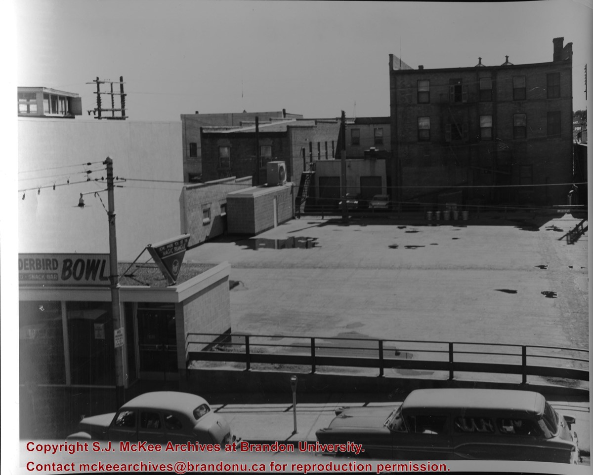
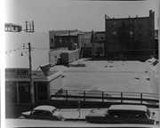
Photograph of an northeast corner 10th Street and Princess Avenue and the rear of buildings facing 200 block on 9th Street. The business in foreground is Thunderbird Bowl. The rear of the Brandon Inn is in the background.
Notes
Photograph dated from "Tara's Bulba," the movie playing at the Strand Theatre and similiar vehicles captured in the photograph.
Name Access
Thunderbird Bowl
10th Street
Subject Access
Brandon business buildings & facilities after 1940
bowling
Storage Location
RG 5 photograph storage drawer
Images
Show Less

Northeast corner 10th Street and Princess Avenue, Brandon, Manitoba (2)

http://archives.brandonu.ca/en/permalink/descriptions8374
Part Of
Joseph H. Hughes collection
Description Level
Item
GMD
graphic
Date Range
1962
Accession Number
3-1997
Part Of
Joseph H. Hughes collection
Description Level
Item
Series Number
3-1997.1
Item Number
3-1997.1.4
Accession Number
3-1997
GMD
graphic
Date Range
1962
Physical Description
8" x 10" (b/w)
Physical Condition
good
Scope and Content
Photograph shows a view of downtown Brandon from the northeast corner of 10th Street and Princess Avenue. Thunderbird Bowl is in the foreground. Painted advertisements on the sides of buildings include: The Mitrou's Cafe and Tea Room and Brandon Musical Supply Ltd. Vehicles parked on 10th Street are facing north.
Notes
Photograph dated from "Tara's Bulba," the movie playing at the Strand Theatre and similiar vehicles captured in the photograph.
Name Access
Thunderbird Bowl
Mitrou Building
Brandon Musical Supply Ltd.
10th Street
Subject Access
downtowns
Brandon business buildings & facilities after 1940
Storage Location
RG 5 photograph storage drawer
Images
Show Less

Northeast corner 10th Street and Princess Avenue, Brandon, Manitoba (3)

http://archives.brandonu.ca/en/permalink/descriptions8375
Part Of
Joseph H. Hughes collection
Description Level
Item
GMD
graphic
Date Range
1962
Accession Number
3-1997
Part Of
Joseph H. Hughes collection
Description Level
Item
Series Number
3-1997.1
Item Number
3-1997.1.5
Accession Number
3-1997
GMD
graphic
Date Range
1962
Physical Description
8" x 10" (b/w)
Physical Condition
good
Scope and Content
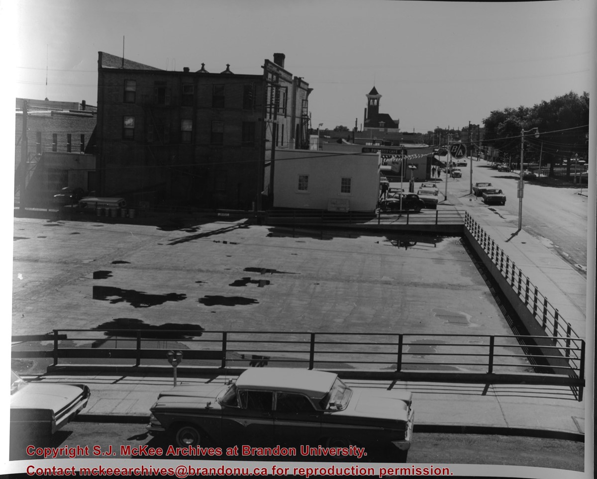
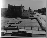
Photograph shows the northeast corner of 10th Street and Princess Avenue facing east. In the background the following Brandon businesses can be seen: back of the Brandon Inn, B/A gas station, The Princess Cafe, and the Central Fire Hall.
Notes
Photograph dated from "Tara's Bulba," the movie playing at the Strand Theatre and similiar vehicles captured in the photograph.
Name Access
Princess Cafe
Central Fire Station
B/A Service Station
Princess Avenue
Subject Access
street scenes
Brandon business buildings & facilities after 1940
Storage Location
RG 5 photograph storage drawer
Images
Show Less

20 records – page 1 of 1.