It appears no script is enabled within your browser. Please enable JavaScript to use this site.
Skip header and navigation
S. J. McKee Archives
Help
Your Selections:
0
Items
Revise Search
Revise Search
Revise search
Search
Fonds / Collection
Aerial views and campus photographs
1
BUPC 2 Campus buildings
1
Brandon University Photograph Collection
10
Brandon University Photograph collection
19
Brandon and Area Photograph Collection
2
CKX fonds
125
Fred McGuinness collection
155
Herbert Goodland collection
4
James Wall collection
35
Joseph H. Hughes collection
46
Maureen Johnson collection
3
RG 1 Brandon College fonds
1
More
×
Fonds / Collection
All
A
B
C
D
E
F
G
H
I
J
K
L
M
N
O
P
Q
R
S
T
U
V
W
X
Y
Z
Sort
By Count
Alphabetical
Filtered by
Filter
Loading...
Material Type
graphic
multiple media
44
sound recordings
1
textual records
60
×
Material Type
All
A
B
C
D
E
F
G
H
I
J
K
L
M
N
O
P
Q
R
S
T
U
V
W
X
Y
Z
Sort
By Count
Alphabetical
Filtered by
Filter
Loading...
Subject
"cat-chers"
1
18th Street Hill
1
Aboriginal groups
6
Aboriginals
6
Aerial views Brandon College
2
Agriculture
33
Alcoholism
2
Animals
1
Archaeology Lovstrom locale Lovstrom Block H
6
Archaeology North lauder locale Flintstone Hill DiMe-26 Flintstone Hill 1998-2000 - Test Unit 4 north profile
2
Arenas
3
Arts 1929
1
More
×
Subject
All
A
B
C
D
E
F
G
H
I
J
K
L
M
N
O
P
Q
R
S
T
U
V
W
X
Y
Z
Sort
By Count
Alphabetical
Filtered by
Filter
Loading...
Name
"The Wheat Market" - Pacific Avenue Brandon
1
000 and 100 Blocks of Ninth Street
1
000 and 100 Blocks of Tenth Street
1
100 Block of Tenth Street
11
1000 Block of Rosser Avenue
4
10th Street
32
10th Street Businesses - East Side of 100 Block
6
10th Street Businesses - West Side of 100 Block
6
11th Street
3
18th Street
1
200 Block of Tenth Street
2
600 Block of Rosser Avenue
1
More
×
Name
All
A
B
C
D
E
F
G
H
I
J
K
L
M
N
O
P
Q
R
S
T
U
V
W
X
Y
Z
Sort
By Count
Alphabetical
Filtered by
Filter
Loading...
Archival Hierarchy
Item
1422
Sub-series
2
×
Archival Hierarchy
All
A
B
C
D
E
F
G
H
I
J
K
L
M
N
O
P
Q
R
S
T
U
V
W
X
Y
Z
Sort
By Count
Alphabetical
Filtered by
Filter
Loading...
Collection Source
Archival Collections
×
Collection Source
All
A
B
C
D
E
F
G
H
I
J
K
L
M
N
O
P
Q
R
S
T
U
V
W
X
Y
Z
Sort
By Count
Alphabetical
Filtered by
Filter
Loading...
Online Media Type
Image
1414
×
Online Media Type
All
A
B
C
D
E
F
G
H
I
J
K
L
M
N
O
P
Q
R
S
T
U
V
W
X
Y
Z
Sort
By Count
Alphabetical
Filtered by
Filter
Loading...
Advanced Search
more like: descriptions4854
Archival Collections
graphic
Print
PDF
Sorted by
Oldest
Sort by Relevance
Sort by Title
Sort by Newest
Expand All
Collapse All
List View
Gallery View
20 records – page 1 of 1.
Prev
Next
Show All Information
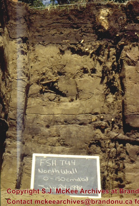
Flintstone Hill 1998-2000 - Test Unit 4 north profile
http://archives.brandonu.ca/en/permalink/descriptions12319
Part Of
RG 7 Beverley Nicholson fonds
Description Level
Item
GMD
graphic
Date Range
1998-2000
Accession Number
1-2010
More Information is Available
1 image
Part Of
RG 7 Beverley Nicholson fonds
Description Level
Item
Series Number
2.2.2.5
Item Number
2.2.2.5.6
Accession Number
1-2010
GMD
graphic
Date Range
1998-2000
Physical Description
536 x 792(244)
Material Details
JPEG
History / Biographical
Photograph taken during 1998-2000 Brandon University Archaeology survey at Flintstone Hill.
Scope and Content
Test Unit 4 north profile, 150 cm deep.
Name Access
Flintstone Hill 1998-2000 - Test Unit 4 north profile
Subject Access
Archaeology North lauder locale Flintstone Hill DiMe-26 Flintstone Hill 1998-2000 - Test Unit 4 north profile
Images
Show Less
Share
Facebook
Twitter
LinkedIn
Pinterest
More Like This
Permalink
Show All Information
Flintstone Hill 1998-2000 - Test Unit 5 north profile
http://archives.brandonu.ca/en/permalink/descriptions12320
Part Of
RG 7 Beverley Nicholson fonds
Description Level
Item
GMD
graphic
Date Range
1998-2000
Accession Number
1-2010
More Information is Available
1 image
Part Of
RG 7 Beverley Nicholson fonds
Description Level
Item
Series Number
2.2.2.5
Item Number
2.2.2.5.7
Accession Number
1-2010
GMD
graphic
Date Range
1998-2000
Physical Description
536 x 796(247)
Material Details
JPEG
History / Biographical
Photograph taken during 1998-2000 Brandon University Archaeology survey at Flintstone Hill.
Scope and Content
Test Unit 5 north profile, 150 cm deep.
Name Access
Flintstone Hill 1998-2000 - Test Unit 5 north profile
Subject Access
Archaeology North lauder locale Flintstone Hill DiMe-26 Flintstone Hill 1998-2000 - Test Unit 4 north profile
Images
Show Less
Share
Facebook
Twitter
LinkedIn
Pinterest
More Like This
Permalink
Show All Information
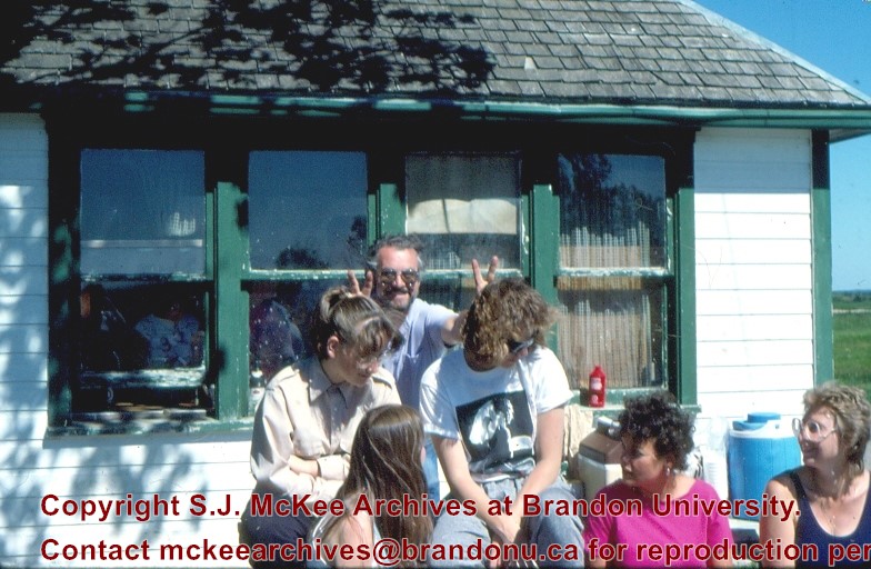
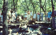
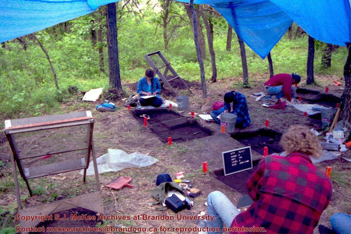
Lovstrom Block H 1988 - crew
http://archives.brandonu.ca/en/permalink/descriptions12695
Part Of
RG 7 Beverley Nicholson fonds
Description Level
Item
GMD
graphic
Date Range
1988
Accession Number
1-2010
More Information is Available
1 image
Part Of
RG 7 Beverley Nicholson fonds
Description Level
Item
Series Number
3.9.1.5
Item Number
3.9.1.5.1
Accession Number
1-2010
GMD
graphic
Date Range
1988
Physical Description
784 x 512(269KB )
Material Details
JPEG
Scope and Content
Crew at the Lovstrom locale.
Name Access
Lovstrom Block H 1988 - crew
Subject Access
Archaeology Lovstrom locale Lovstrom Block H
Images
Show Less
Share
Facebook
Twitter
LinkedIn
Pinterest
More Like This
Permalink
Show All Information
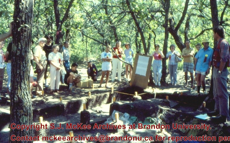
Lovstrom Block H 1988 - tour
http://archives.brandonu.ca/en/permalink/descriptions12696
Part Of
RG 7 Beverley Nicholson fonds
Description Level
Item
GMD
graphic
Date Range
1988
Accession Number
1-2010
More Information is Available
1 image
Part Of
RG 7 Beverley Nicholson fonds
Description Level
Item
Series Number
3.9.1.5
Item Number
3.9.1.5.2
Accession Number
1-2010
GMD
graphic
Date Range
1988
Physical Description
784 x 488(338KB )
Material Details
JPEG
Scope and Content
Group tours were encouraged to arrange a visit to the Lovstrom locale.
Name Access
Lovstrom Block H 1988 - tour
Subject Access
Archaeology Lovstrom locale Lovstrom Block H
Images
Show Less
Share
Facebook
Twitter
LinkedIn
Pinterest
More Like This
Permalink
Show All Information
Lovstrom Block H 1991 - crew
http://archives.brandonu.ca/en/permalink/descriptions12701
Part Of
RG 7 Beverley Nicholson fonds
Description Level
Item
GMD
graphic
Date Range
1991
Accession Number
1-2010
More Information is Available
1 image
Part Of
RG 7 Beverley Nicholson fonds
Description Level
Item
Series Number
3.9.2.5
Item Number
3.9.2.5.1
Accession Number
1-2010
GMD
graphic
Date Range
1991
Physical Description
1200 x 800(909KB )
Material Details
JPEG
Scope and Content
Crew at Block H, the Lovstrom locale.
Name Access
Lovstrom Block H 1991 - crew
Subject Access
Archaeology Lovstrom locale Lovstrom Block H
Images
Show Less
Share
Facebook
Twitter
LinkedIn
Pinterest
More Like This
Permalink
Show All Information
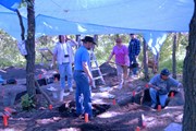
Lovstrom Block H 1991 - Dr. Dennis Anderson at the site
http://archives.brandonu.ca/en/permalink/descriptions12702
Part Of
RG 7 Beverley Nicholson fonds
Description Level
Item
GMD
graphic
Date Range
1991
Accession Number
1-2010
More Information is Available
1 image
Part Of
RG 7 Beverley Nicholson fonds
Description Level
Item
Series Number
3.9.2.5
Item Number
3.9.2.5.2
Accession Number
1-2010
GMD
graphic
Date Range
1991
Physical Description
1200 x 800(961KB )
Material Details
JPEG
Scope and Content
Brandon University president Dr. Dennis Anderson at the site.
Name Access
Lovstrom Block H 1991 - Dr. Dennis Anderson at the site
Subject Access
Archaeology Lovstrom locale Lovstrom Block H
Images
Show Less
Share
Facebook
Twitter
LinkedIn
Pinterest
More Like This
Permalink
Show All Information
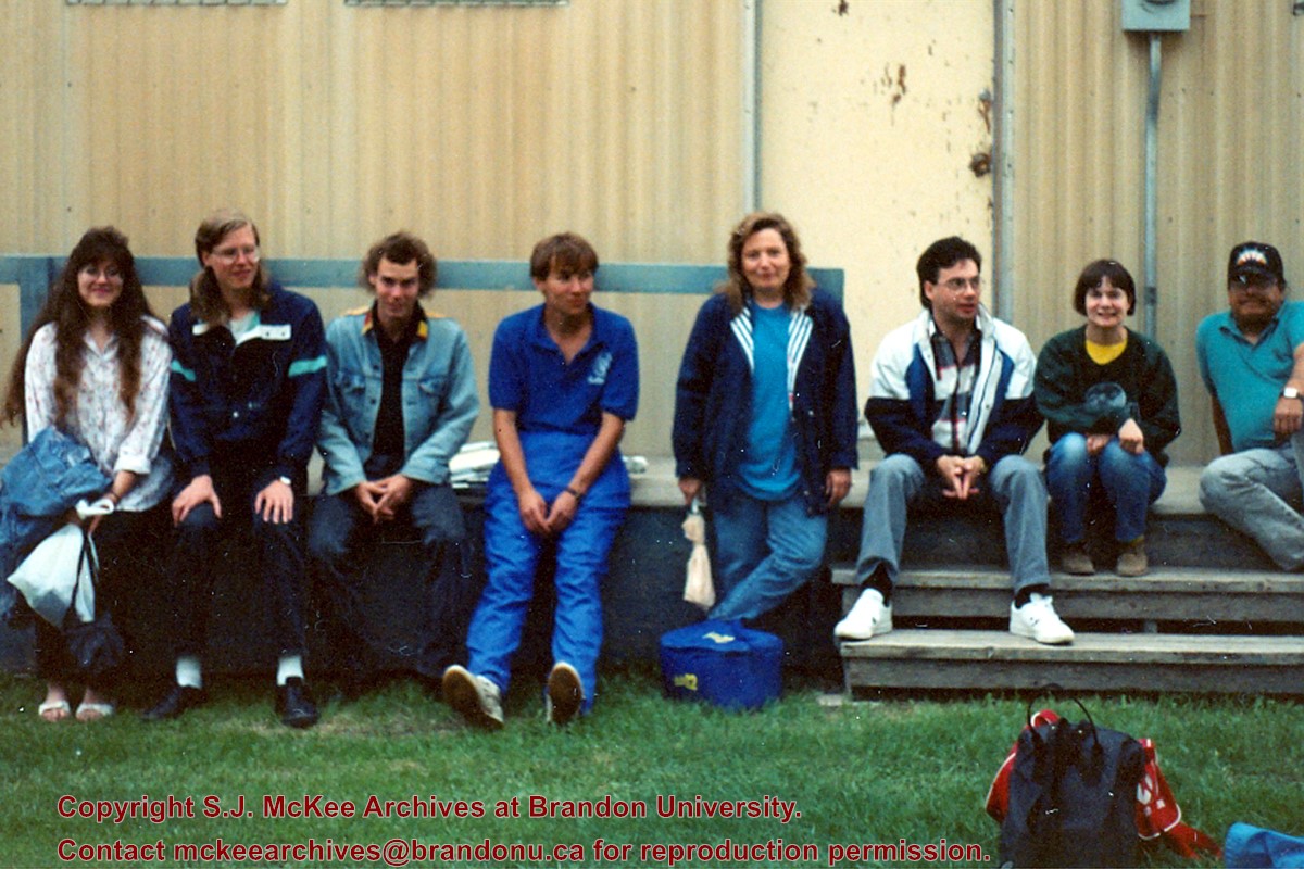
Lovstrom Block H 1991 - Group picture of Lovstrom crew
http://archives.brandonu.ca/en/permalink/descriptions12703
Part Of
RG 7 Beverley Nicholson fonds
Description Level
Item
GMD
graphic
Date Range
1991
Accession Number
1-2010
More Information is Available
1 image
Part Of
RG 7 Beverley Nicholson fonds
Description Level
Item
Series Number
3.9.2.5
Item Number
3.9.2.5.3
Accession Number
1-2010
GMD
graphic
Date Range
1991
Physical Description
1200 x 800(961KB )
Material Details
JPEG
Scope and Content
Group picture of Lovstrom crew.
Name Access
Lovstrom Block H 1991 - Group picture of Lovstrom crew
Subject Access
Archaeology Lovstrom locale Lovstrom Block H
Images
Show Less
Share
Facebook
Twitter
LinkedIn
Pinterest
More Like This
Permalink
Show All Information
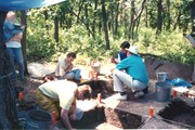
Lovstrom Block H 1991 - crew at the site
http://archives.brandonu.ca/en/permalink/descriptions12704
Part Of
RG 7 Beverley Nicholson fonds
Description Level
Item
GMD
graphic
Date Range
1991
Accession Number
1-2010
More Information is Available
1 image
Part Of
RG 7 Beverley Nicholson fonds
Description Level
Item
Series Number
3.9.2.5
Item Number
3.9.2.5.4
Accession Number
1-2010
GMD
graphic
Date Range
1991
Physical Description
1200 x 800(953KB )
Material Details
JPEG
Scope and Content
Block H crew at the site.
Name Access
Lovstrom Block H 1991 - crew at the site
Subject Access
Archaeology Lovstrom locale Lovstrom Block H
Images
Show Less
Share
Facebook
Twitter
LinkedIn
Pinterest
More Like This
Permalink
Show All Information
Making the Ford work for its keep
http://archives.brandonu.ca/en/permalink/descriptions12715
Part Of
Herbert Goodland collection
Description Level
Item
GMD
graphic
Date Range
[1913-1915]
Accession Number
17-2011
More Information is Available
1 image
Part Of
Herbert Goodland collection
Description Level
Item
Item Number
17-2011.6
Accession Number
17-2011
GMD
graphic
Date Range
[1913-1915]
Physical Description
5.75" x 3.25" (b/w)
Custodial History
For custodial history see collection level description.
Scope and Content
Photograph of two Brandon Indian Residential School pupils and an instructor harvesting hay.
Subject Access
residential schools
agricultural products
agricultural machinery
harvesting
vocational education
Storage Location
2011 accessions
Images
Show Less
Share
Facebook
Twitter
LinkedIn
Pinterest
More Like This
Permalink
Show All Information
Brandon Indian School farm
http://archives.brandonu.ca/en/permalink/descriptions12717
Part Of
Herbert Goodland collection
Description Level
Item
GMD
graphic
Date Range
[1913-1915]
Accession Number
17-2011
More Information is Available
1 image
Part Of
Herbert Goodland collection
Creator
Photographer: T.B. Barner
Description Level
Item
Item Number
17-2011.8
Accession Number
17-2011
GMD
graphic
Date Range
[1913-1915]
Physical Description
6" x 4.25" (b/w)
Custodial History
For custodial history see collection level description.
Scope and Content
Photograph of students in the Brandon Indian Residential School farm.
Subject Access
residential schools
farming
gardens
vocational education
Storage Location
2011 accessions
Images
Show Less
Share
Facebook
Twitter
LinkedIn
Pinterest
More Like This
Permalink
Show All Information
Brandon Indian School garden boys
http://archives.brandonu.ca/en/permalink/descriptions12719
Part Of
Herbert Goodland collection
Description Level
Item
GMD
graphic
Date Range
[1913-1915]
Accession Number
17-2011
More Information is Available
1 image
Part Of
Herbert Goodland collection
Creator
Photographer: T.B. Barner
Description Level
Item
Item Number
17-2011.10
Accession Number
17-2011
GMD
graphic
Date Range
[1913-1915]
Physical Description
6.5" x 5" (b/w)
Custodial History
For custodial history see collection level description.
Scope and Content
Photograph of students and instructors in the Brandon Indian Residential School garden.
Subject Access
residential schools
farming
gardens
vocational education
Storage Location
2011 accessions
Images
Show Less
Share
Facebook
Twitter
LinkedIn
Pinterest
More Like This
Permalink
Show All Information
Brandon Indian School garden boys
http://archives.brandonu.ca/en/permalink/descriptions12720
Part Of
Herbert Goodland collection
Description Level
Item
GMD
graphic
Date Range
[1913-1915]
Accession Number
17-2011
More Information is Available
1 image
Part Of
Herbert Goodland collection
Description Level
Item
Item Number
17-2011.11
Accession Number
17-2011
GMD
graphic
Date Range
[1913-1915]
Physical Description
4.25" x 6" (b/w)
Custodial History
For custodial history see collection level description.
Scope and Content
Photograph of students in the Brandon Indian Residential School garden.
Subject Access
residential schools
farming
gardens
vocational education
Storage Location
2011 accessions
Images
Show Less
Share
Facebook
Twitter
LinkedIn
Pinterest
More Like This
Permalink
Show All Information
Winter Carnival
http://archives.brandonu.ca/en/permalink/descriptions12747
Part Of
CKX fonds
Description Level
Item
GMD
graphic
Date Range
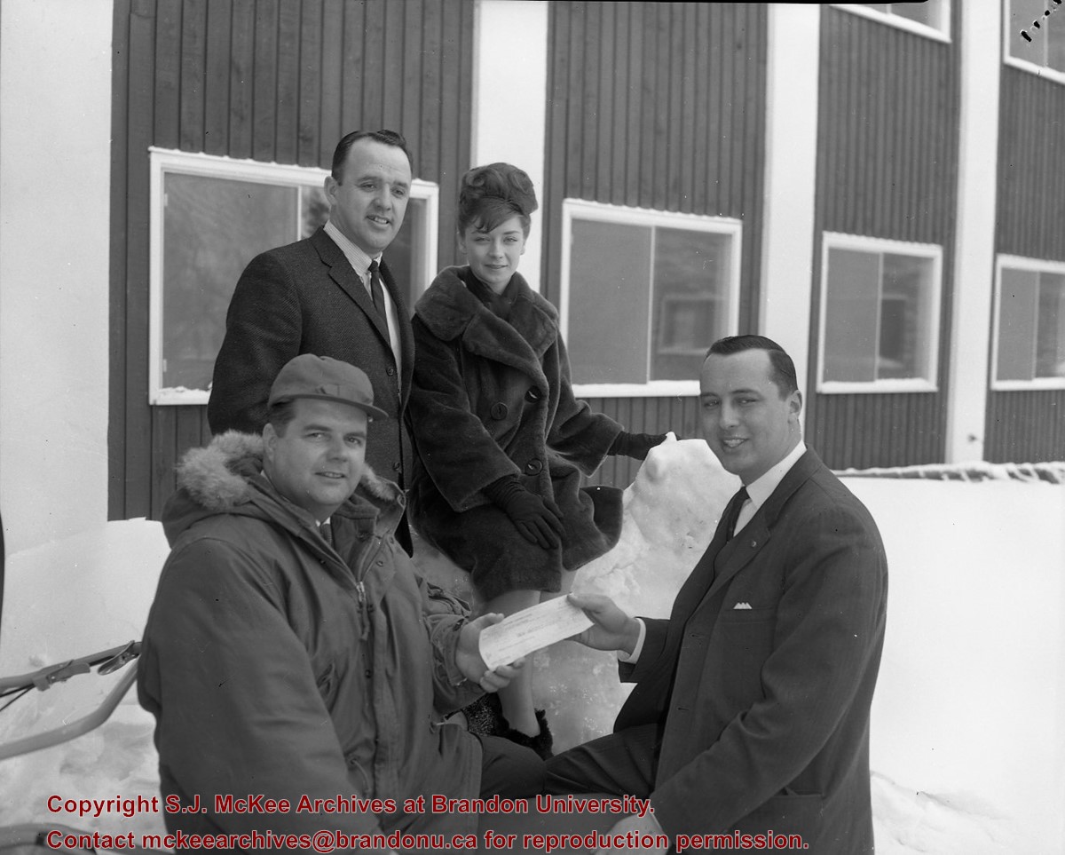
February 15 1965
Accession Number
11-2010
More Information is Available
1 image
Part Of
CKX fonds
Creator
CKX
Description Level
Item
Series Number
W
Item Number
11-2010.W69a
Accession Number
11-2010
GMD
graphic
Date Range
February 15 1965
Physical Description
5" x 4" (b/w)
Material Details
Negative
Custodial History
See fonds level of the CKX records for custodial history.
Scope and Content
Image of 4 people standing outside while two of them are holding a cheque.
Name Access
CKX
Subject Access
persons
cheque presentations
winter
Storage Location
CKX fonds - 2010 accessions
Images
Show Less
Share
Facebook
Twitter
LinkedIn
Pinterest
More Like This
Permalink
Show All Information
Wheat City Dry Cleaners
http://archives.brandonu.ca/en/permalink/descriptions12749
Part Of
CKX fonds
Description Level
Item
GMD
graphic
Date Range
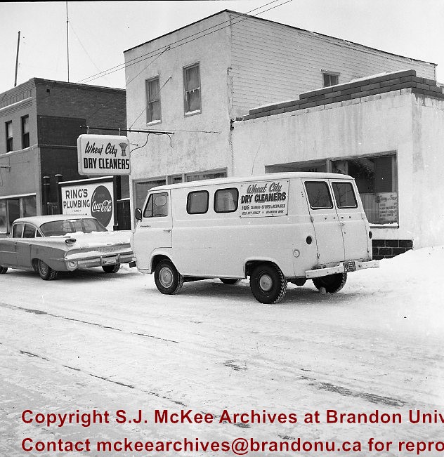
1966
Accession Number
11-2010
More Information is Available
1 image
Part Of
CKX fonds
Creator
CKX
Description Level
Item
Series Number
W
Item Number
11-2010.W67
Accession Number
11-2010
GMD
graphic
Date Range
1966
Physical Description
2.5" x 2.5" (b/w)
Material Details
Negative
Custodial History
See fonds level of the CKX records for custodial history.
Scope and Content
Image of Wheat City Dry Cleaners store from the street with their van parked out front.
Name Access
CKX
Wheat City Dry Cleaners
Ring's Plumbing
Subject Access
store exteriors
building exteriors
winter
signs and signboards
Storage Location
CKX fonds - 2010 accessions
Images
Show Less
Share
Facebook
Twitter
LinkedIn
Pinterest
More Like This
Permalink
Show All Information
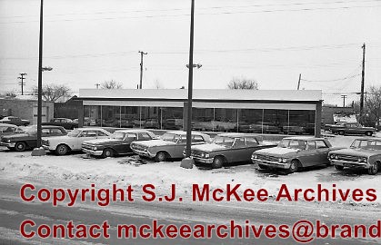
Wilton Motors (UCL)
http://archives.brandonu.ca/en/permalink/descriptions12798
Part Of
CKX fonds
Description Level
Item
GMD
graphic
Date Range
1967
Accession Number
11-2010
More Information is Available
1 image
Part Of
CKX fonds
Creator
CKX
Description Level
Item
Series Number
W
Item Number
11-2010.W43
Accession Number
11-2010
GMD
graphic
Date Range
1967
Physical Description
1.5" x 1.5" (b/w)
Material Details
Negative
Custodial History
See fonds level of the CKX records for custodial history.
Scope and Content
Image of cars.
Name Access
CKX
Wilton Motors
Subject Access
cars
car lots
automobile dealerships
winter
Storage Location
CKX fonds - 2010 accessions
Images
Show Less
Share
Facebook
Twitter
LinkedIn
Pinterest
More Like This
Permalink
Show All Information
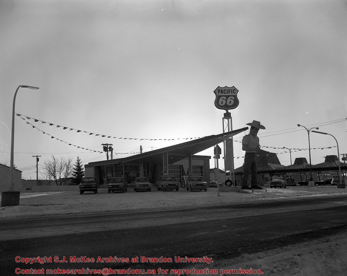
Westside 66 service
http://archives.brandonu.ca/en/permalink/descriptions12875
Part Of
CKX fonds
Description Level
Item
GMD
graphic
Date Range
1969
Accession Number
11-2010
More Information is Available
1 image
Part Of
CKX fonds
Creator
CKX
Description Level
Item
Series Number
W
Item Number
11-2010.W4c
Accession Number
11-2010
GMD
graphic
Date Range
1969
Physical Description
5" x 4" (b/w)
Material Details
Negative
Custodial History
See fonds level of the CKX records for custodial history.
Scope and Content
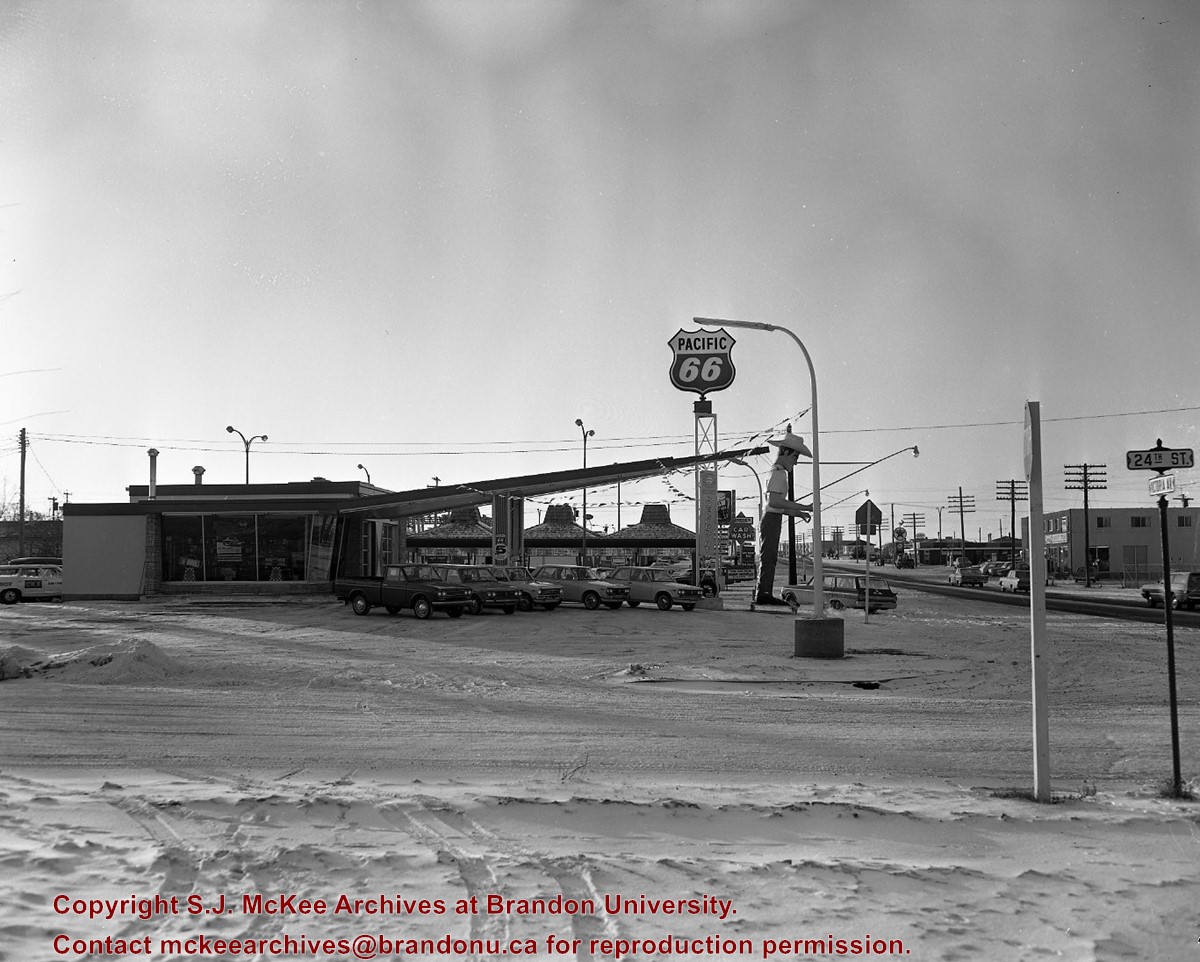
Image of the Westside 66 service building.
Name Access
CKX
Westside 66
Subject Access
building exteriors
service stations
signs and signboards
cars
winter
Storage Location
CKX fonds - 2010 accessions
Images
Show Less
Share
Facebook
Twitter
LinkedIn
Pinterest
More Like This
Permalink
Show All Information
Westside 66 service
http://archives.brandonu.ca/en/permalink/descriptions12876
Part Of
CKX fonds
Description Level
Item
GMD
graphic
Date Range
1969
Accession Number
11-2010
More Information is Available
1 image
Part Of
CKX fonds
Creator
CKX
Description Level
Item
Series Number
W
Item Number
11-2010.W4b
Accession Number
11-2010
GMD
graphic
Date Range
1969
Physical Description
5" x 4" (b/w)
Material Details
Negative
Custodial History
See fonds level of the CKX records for custodial history.
Scope and Content
Image of the Westside 66 service building.
Name Access
CKX
Westside 66
Subject Access
building exteriors
service stations
signs and signboards
cars
winter
Storage Location
CKX fonds - 2010 accessions
Images
Show Less
Share
Facebook
Twitter
LinkedIn
Pinterest
More Like This
Permalink
Show All Information
Westside 66 service
http://archives.brandonu.ca/en/permalink/descriptions12877
Part Of
CKX fonds
Description Level
Item
GMD
graphic
Date Range
1969
Accession Number
11-2010
More Information is Available
1 image
Part Of
CKX fonds
Creator
CKX
Description Level
Item
Series Number
W
Item Number
11-2010.W4a
Accession Number
11-2010
GMD
graphic
Date Range
1969
Physical Description
5" x 4" (b/w)
Material Details
Negative
Custodial History
See fonds level of the CKX records for custodial history.
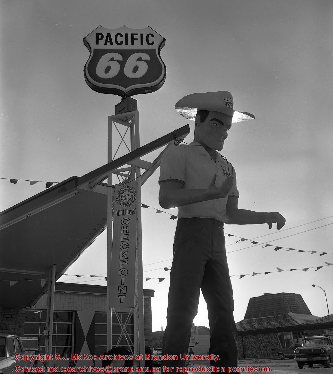
Scope and Content
Image of the Westside 66 service mascot.
Name Access
CKX
Westside 66
Subject Access
building exteriors
service stations
signs and signboards
cars
winter
mascots
Storage Location
CKX fonds - 2010 accessions
Images
Show Less
Share
Facebook
Twitter
LinkedIn
Pinterest
More Like This
Permalink
Show All Information
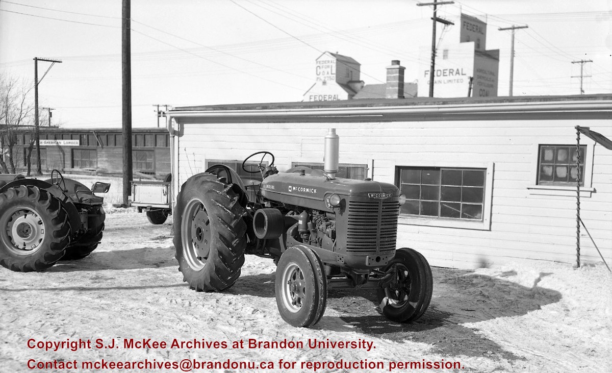
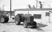
H.E. Wright Farm Equipment
http://archives.brandonu.ca/en/permalink/descriptions12878
Part Of
CKX fonds
Description Level
Item
GMD
graphic
Date Range
after 1954
Accession Number
11-2010
More Information is Available
1 image
Part Of
CKX fonds
Creator
CKX
Description Level
Item
Series Number
W
Item Number
11-2010.W3b
Accession Number
11-2010
GMD
graphic
Date Range
after 1954
Physical Description
5" x 4" (b/w)
Material Details
Negative
Custodial History
See fonds level of the CKX records for custodial history.
Scope and Content
Image of a tractor.
Name Access
CKX
H.E. Wright Farm Equipment
Federal Grain Limited
Subject Access
building exteriors
Grain elevators
Agriculture
Tractors
winter
Storage Location
CKX fonds - 2010 accessions
Images
Show Less
Share
Facebook
Twitter
LinkedIn
Pinterest
More Like This
Permalink
Show All Information
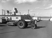
H.E. Wright Farm Equipment
http://archives.brandonu.ca/en/permalink/descriptions12879
Part Of
CKX fonds
Description Level
Item
GMD
graphic
Date Range
after 1954
Accession Number
11-2010
More Information is Available
1 image
Part Of
CKX fonds
Creator
CKX
Description Level
Item
Series Number
W
Item Number
11-2010.W3a
Accession Number
11-2010
GMD
graphic
Date Range
after 1954
Physical Description
5" x 4" (b/w)
Material Details
Negative
Custodial History
See fonds level of the CKX records for custodial history.
Scope and Content
Image of a tractor.
Name Access
CKX
H.E. Wright Farm Equipment
Federal Grain Limited
Subject Access
building exteriors
Grain elevators
Agriculture
Tractors
cars
businesses
Storage Location
CKX fonds - 2010 accessions
Images
Show Less
Share
Facebook
Twitter
LinkedIn
Pinterest
More Like This
Permalink
20 records – page 1 of 1.
Prev
Next
.jpg?width=1200&404=no-img.jpg&watermark=wmk)
.jpg?width=180&404=no-img.jpg)


/17-2011_6.jpg?width=1200&404=no-img.jpg&watermark=wmk)
/17-2011_6.jpg?width=180&404=no-img.jpg)
/17-2011_8.jpg?width=1200&404=no-img.jpg&watermark=wmk)
/17-2011_8.jpg?width=180&404=no-img.jpg)
/17-2011_10.jpg?width=1200&404=no-img.jpg&watermark=wmk)
/17-2011_10.jpg?width=180&404=no-img.jpg)
/17-2011_11.jpg?width=1200&404=no-img.jpg&watermark=wmk)
/17-2011_11.jpg?width=180&404=no-img.jpg)

.jpg%3fmaxheight%3d1000%26maxwidth%3d1000%26watermark%3dwmk&description=Flintstone+Hill+1998-2000+-+Test+Unit+5+north+profile)
%2f17-2011_6.jpg%3fmaxheight%3d1000%26maxwidth%3d1000%26watermark%3dwmk&description=Making+the+Ford+work+for+its+keep)
%2f17-2011_8.jpg%3fmaxheight%3d1000%26maxwidth%3d1000%26watermark%3dwmk&description=Brandon+Indian+School+farm)
%2f17-2011_10.jpg%3fmaxheight%3d1000%26maxwidth%3d1000%26watermark%3dwmk&description=Brandon+Indian+School+garden+boys)
%2f17-2011_11.jpg%3fmaxheight%3d1000%26maxwidth%3d1000%26watermark%3dwmk&description=Brandon+Indian+School+garden+boys)
)